Review of Regional Weather and Smoke Haze for Apr 2016
1. Review of Regional Weather Conditions in April 2016
1.1 Inter Monsoon conditions characterised by light winds afternoon shower activities, particularly in the near-equatorial region prevailed in April 2016. In the northern ASEAN region, dry weather conditions persisted in the first half of April but there was a gradual increase of shower activities by late April 2016. Similar conditions were experienced in Peninsular Malaysia, Sabah and East Kalimantan. For parts of Sumatra and West Kalimantan, it was generally wet weather on most days of the month.
1.2 The drier and warmer than usual weather conditions which started since March 2016 continued in April 2016. Prolonged dry weather conditions affected many parts of the ASEAN region including Peninsular Malaysia, Philippines and countries in the Mekong Sub-region. High temperatures were also experienced in Thailand and Peninsular Malaysia where the maximum temperatures were reported to have exceeded 40 degrees Celsius in parts of Thailand. On 28 April 2016, the maximum temperature in Maehongsorn reached 44.3 degrees Celsius while in Peninsular Malaysia, maximum temperatures of between 35 to 39.2 degrees Celsius were reported in parts of the Malaysian States of Selangor, Perlis and Pahang.
1.3 1.3 For April 2016, most of the areas north of the equator including the northern ASEAN region, Peninsular Malaysia and Sabah received less than 100% of normal rainfall. Normal to above-normal rainfall were recorded in Sumatra, Kalimantan and the islands of Java. The regional rainfall distribution for April 2016 is shown in Figure Fig. 1A.

2. Review of Land/Forest Fires and Smoke Haze Situation
2.1 The fire-prone provinces of Sumatra and Kalimantan experienced wet weather conditions on most days in April 2016, and the showers helped to subdue the hotspot activities there. On the contrary, in parts of Peninsular Malaysia and Sabah, the drier than usual weather conditions contributed to the occurrence of localised hotspots and smoke haze on several days. In Beaufort, Sabah, for example, localized burning led to a deterioration of air quality where the Air Pollution Index (API) reached a high of 308 on 4 April 2016. On a few days around 22 April 2016, smoke haze from localized peat fires in Kuala Langat and Sepang in Selangor, Peninsular Malaysia affected the parts of Selangor including Shah Alam and Cheras where API readings were in the Unhealthy range for a few hours.
2.2 In the northern ASEAN region, with dry weather conditions persisting in the first half of April 2016, the hotspot activities continued to be high. Scattered hotspots and smoke haze were observed in the northern parts of Thailand, Lao PDR, as well as over the ranges west of Nakhon Sawan province and in parts of Cambodia. PM10 concentration levels in Chiang Mai, Chiangrai and Maehongsorn exceeded 120ug/m3 on several days in April 2016.
2.3 An increase in shower activities in the northern ASEAN region in the latter half of April 2016 helped to ease the haze situation in the Mekong Sub-region, which also brought a reduction to the number of hotspots detected.
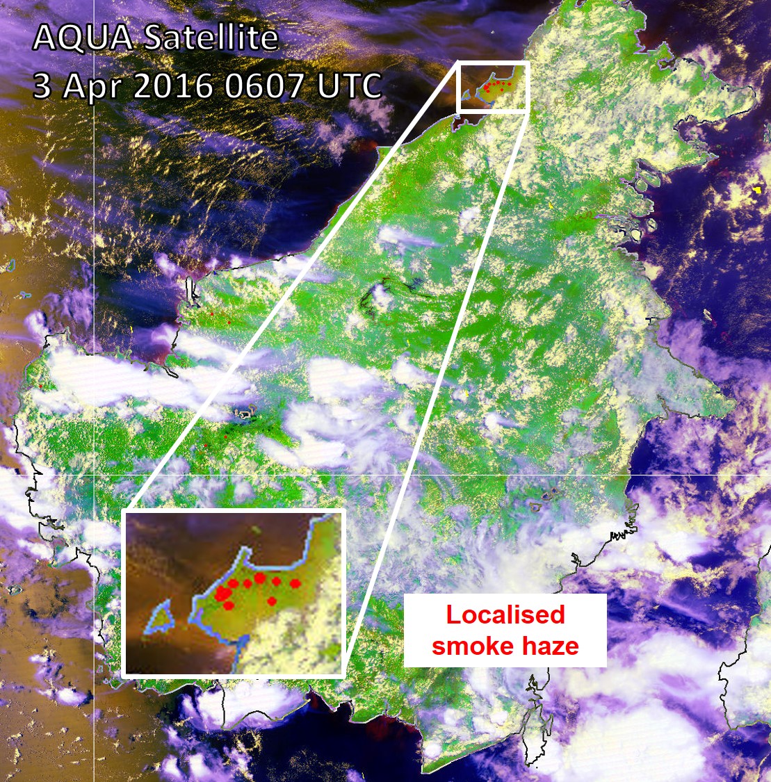
Fig. 2A: AQUA satellite image on 3 April 2016 shows localised smoke plumes emanating from hotspots detected in Beaufort, Sabah.

Fig. 2B: AQUA satellite image on 5 April 2016 shows scattered hotspots and smoke haze in the northern parts of Mekong Sub-region.

Figure 2C: AQUA satellite image on 15 April 2016 shows scattered hotspots in the northern parts of Mekong Sub-region. Smoke haze was observed to spread over the northern border areas of Vietnam.

Fig. 2D: AQUA satellite image on 19 April 2016 shows localised smoke plumes emanating from isolated hotspots in central Pahang, Malaysia.

Fig. 2E: AQUA satellite image on 25 April 2016 shows shower activities over parts of Peninsular Malaysia and Sumatra.
2.3 The hotspot charts for April 2016 for
- Cambodia, Myanmar, Thailand, Lao PDR and Vietnam;
- Sumatra, Borneo and Peninsular Malaysia;

Fig. 2F: Hotspot Counts in Cambodia, Lao PDR, Thailand, Vietnam, Myanmar for April 2016.

Fig 2G: Hotspot Counts in Sumatra, Borneo and Peninsular Malaysia for April 2016.
3. Status of El Niño/La Niña
3.1 The El Niño has been gradually weakening over the past few months and based on the latest assessment, is at a moderate-to-weak level. The trade winds over the tropical Pacific Ocean are near normal, and cloudiness near the dateline is less typical of El Niño conditions.
3.2 Large-scale rainfall response to the El Niño in terms of widespread, drier-than-normal conditions was observed over many parts of the Southeast Asia region for April 2016. International climate models and expert assessment suggests that the current El Niño is likely to weaken by the mid-2016, and there is a chance of La Niña developing in the third quarter of 2016. However, there is still a possibility of Neutral conditions persisting for the second half of 2016.
3.3 The region is currently in the Inter-Monsoon period (Apr – May), and the impact of El Niño (La Niña) is usually less pronounced as compared to the Southwest Monsoon season (Jun – Sep). Typically, El Niño (La Niña) will bring drier (wetter) than average rainfall conditions over to the southern and eastern parts of the region but less significant impact to the northern and western parts of the region during this period. More locally-specific impact differs from place to place and for different seasons.