

Seasonal Forecast for September- November 2026
Updated 2 September 2026
Southwest Monsoon conditions persisted over the ASEAN region in August 2026 and are expected to continue through early October. During the Southwest Monsoon, the prevailing low-level winds typically blow mainly from the southeast or southwest, and the monsoon rain band remains north of the Equator, corresponding to the dry season for the southern ASEAN region, and the wet season for the northern ASEAN region. Around early October, the Southwest Monsoon typically transitions into the inter-monsoon period, as the prevailing winds become light and variable in direction. Shower activity over the equatorial region also typically increases as the monsoon rain band shifts southwards towards the Equator.
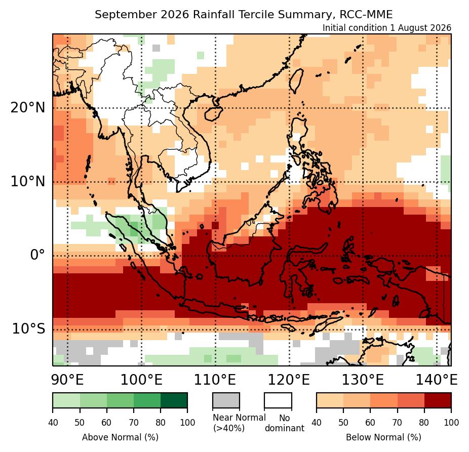
For September 2026, below-normal rainfall is predicted for much of the ASEAN region, with the highest probability over the southern half of the Maritime Continent. During September – November (SON), models predict a high chance of below-normal rainfall over much of the Maritime Continent. El Niño conditions are present and predicted to be strong during the September to November period. El Niño conditions tend to lead to an increased chance of below-normal rainfall for much of the ASEAN region during SON. During September and SON 2026, above-normal temperature is expected over most of the ASEAN region.
Under El Niño conditions and with below-normal rainfall expected over most of the southern ASEAN region during the outlook period, the hotspot and smoke haze situation could remain escalated, with a heightened risk of transboundary haze under the prevailing southeasterly or southwesterly winds. With strong El Niño conditions predicted throughout the outlook period, there is a higher likelihood of periods of prolonged dry conditions, creating conditions more conducive to fire occurrence and increasing the risk of transboundary haze. The increased shower activity around October brought about by the transition from the Southwest Monsoon into the inter-monsoon period could bring some relief to the hotspot and smoke haze situation. While the hotspot and smoke haze situation is expected to remain subdued over the northern ASEAN region, the risk of hotspot activity could increase in areas where below-normal rainfall is predicted.
The qualitative outlook is assessed for the region in general and based on the latest runs from models provided by the SEA RCC-Network LRF node. For specific updates on the national scale, the relevant ASEAN National Meteorological and Hydrological Services should be consulted.
For September 2026, below-normal rainfall is predicted for much of Southeast Asia, with the highest probability over the southern half of the Maritime Continent.
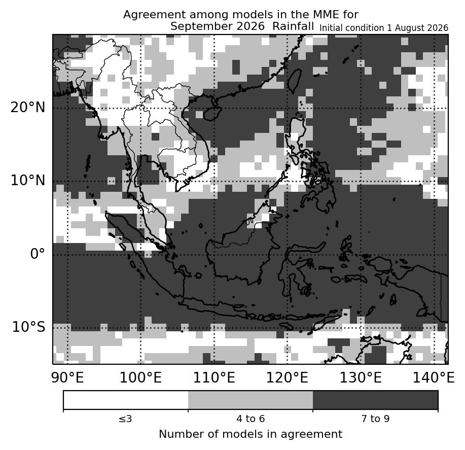
For September 2026, below-normal rainfall is predicted over most of the Maritime Continent based on the multi-model ensemble (Figure 1). The highest probability of below-normal rainfall is over the southern half of the Maritime Continent. However, most of the models (more than six models) predict below-normal rainfall as the dominant tercile for most of the Maritime Continent, apart from the northwestern Maritime Continent, where a slight increase in chance of above-normal rainfall is predicted, and parts of the northeastern Maritime Continent, where much of the models predict below-normal rainfall (four to six models). Model skill for below-normal rainfall is good over the southern half of the Maritime Continent and low to moderate elsewhere. Model skill for above-normal rainfall over the northwestern Maritime Continent is low to moderate.
For Mainland Southeast Asia, a slight increase in chance of below-normal rainfall is predicted for most of the region (Figure 1), apart from northern and southeastern Mainland Southeast Asia where there is little to no agreement between the models (Figure 2). Much of the models (four to six) are in agreement for the regions of Mainland Southeast Asia where below-normal rainfall is predicted based on the multi-model ensemble. Model skill is low to moderate for predicting below-normal rainfall over Mainland Southeast Asia.
|
|
| Figure 1: Rainfall tercile summary predictions of the multi model ensemble for September 2026 (contains modified Copernicus C3S information). | Figure 2: Number of models in agreement in the multi-model ensemble for the dominant tercile for September 2026. Where there no dominant tercile, it refers to the number of models with near-normal tercile (contains modified Copernicus C3S information). |
|
|
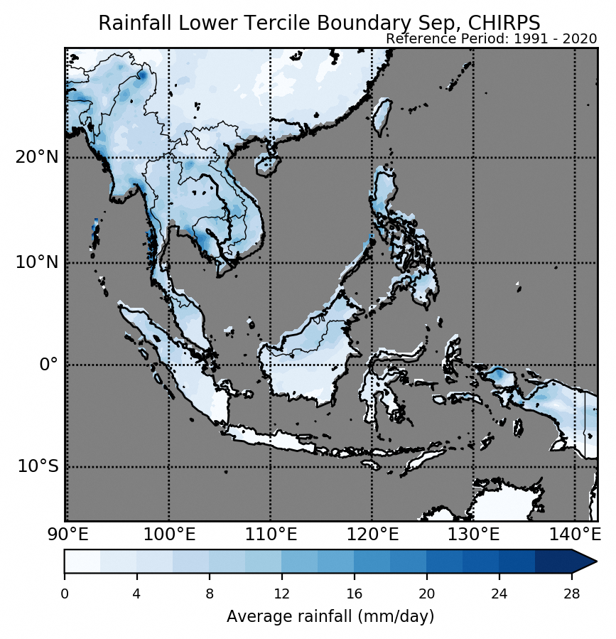
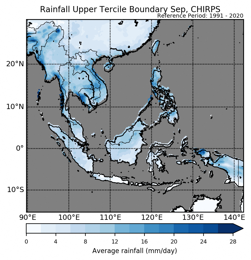
| Figure 3: Average climatological rainfall’s lower tercile boundary for September based on CHIRPS (reference period: 1991-2020). | Figure 4: Average climatological rainfall’s upper tercile boundary for September based on CHIRPS (reference period: 1991-2020). |
The qualitative outlook is assessed for the region in general. For specific updates on the national scale, the relevant ASEAN National Meteorological and Hydrological Services should be consulted. More outlook and verification plots, including for tercile and quintile probabilistic forecasts for rainfall, are in the “Model products and verification: NCEP, ECMWF, UK Met Office” on the SEA-RCC Network LRF Node webpages.
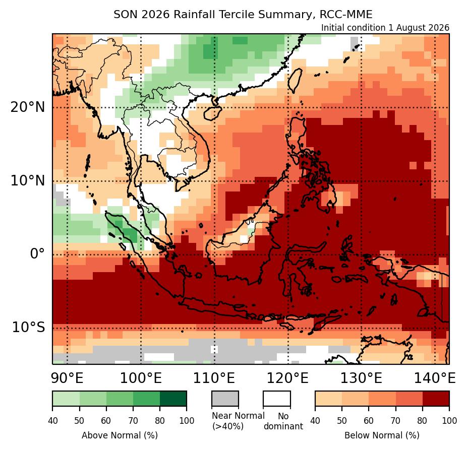
For SON 2026, models predict below-normal rainfall over most of the Maritime Continent.
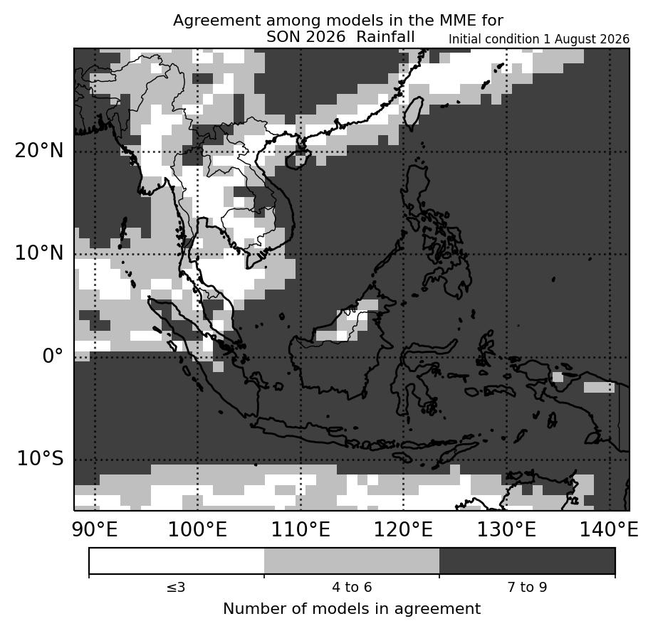
For SON 2026, a high probability of below-normal rainfall is predicted over most of the Maritime Continent based on the multi-model ensemble (Figure 1). The exceptions are over the northwestern Maritime Continent, where above-normal rainfall is predicted, and parts of Borneo, where there is less agreement between the models (four to six models in agreement that below-normal rainfall is the most likely tercile). Otherwise, most models agree that below-normal rainfall is the most likely tercile for SON (Figure 2). Model skill for below-normal rainfall is good over the Maritime Continent where a high probability of below-normal rainfall is predicted, and low to moderate elsewhere. Model skill for above-normal rainfall over the northwestern Maritime Continent is low to moderate.
For much of Mainland Southeast Asia, there is little agreement between the models (Figure 2). The main exceptions are over parts of eastern and coastal western Mainland Southeast Asia, where much of the models (four to six) predict below-normal rainfall as the most likely tercile, and parts of northern Mainland Southeast Asia, where much to most (four or more) models predict above-normal rainfall as the most likely tercile. Model skill is low for above-normal rainfall over northern Mainland Southeast Asia. For below-normal rainfall, model skill is moderate to good over southern and eastern Mainland Southeast Asia, and low elsewhere.
|
|
| Figure 1: Rainfall tercile summary predictions of the multi model ensemble for SON 2026 (contains modified Copernicus C3S information). | Figure 2: Number of models in agreement in the multi-model ensemble for the dominant tercile for SON 2026. Where there no dominant tercile, it refers to the number of models with near-normal tercile (contains modified Copernicus C3S information). |
|
|
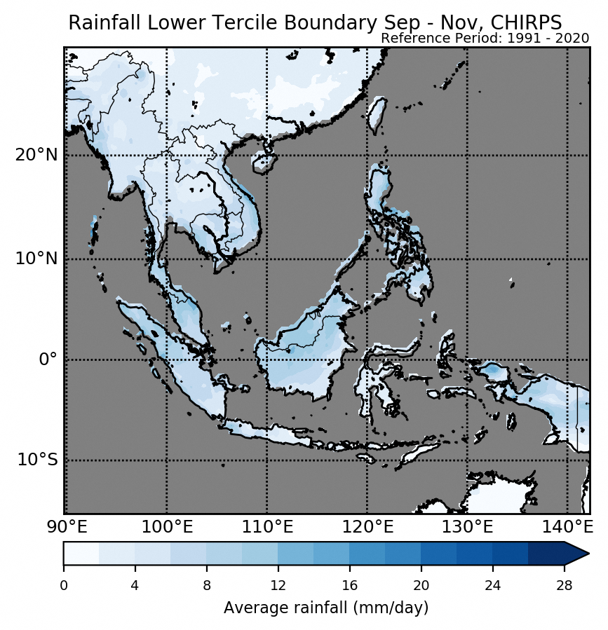
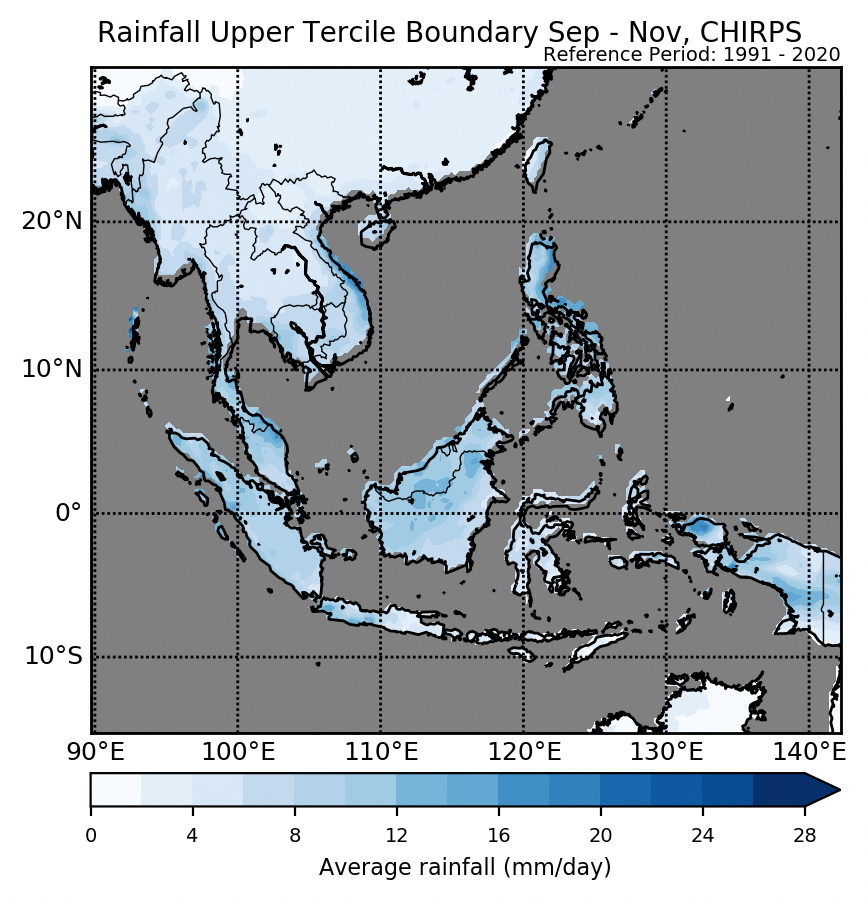
| Figure 3: Average climatological rainfall’s lower tercile boundary for SON based on CHIRPS (reference period: 1991-2020). | Figure 4: Average climatological rainfall’s upper tercile boundary for SON based on CHIRPS (reference period: 1991-2020). |
The qualitative outlook is assessed for the region in general. For specific updates on the national scale, the relevant ASEAN National Meteorological and Hydrological Services should be consulted. More outlook and verification plots, including for tercile and quintile probabilistic forecasts for rainfall, are in the “Model products and verification: NCEP, ECMWF, UK Met Office” on the SEA-RCC Network LRF Node webpages.
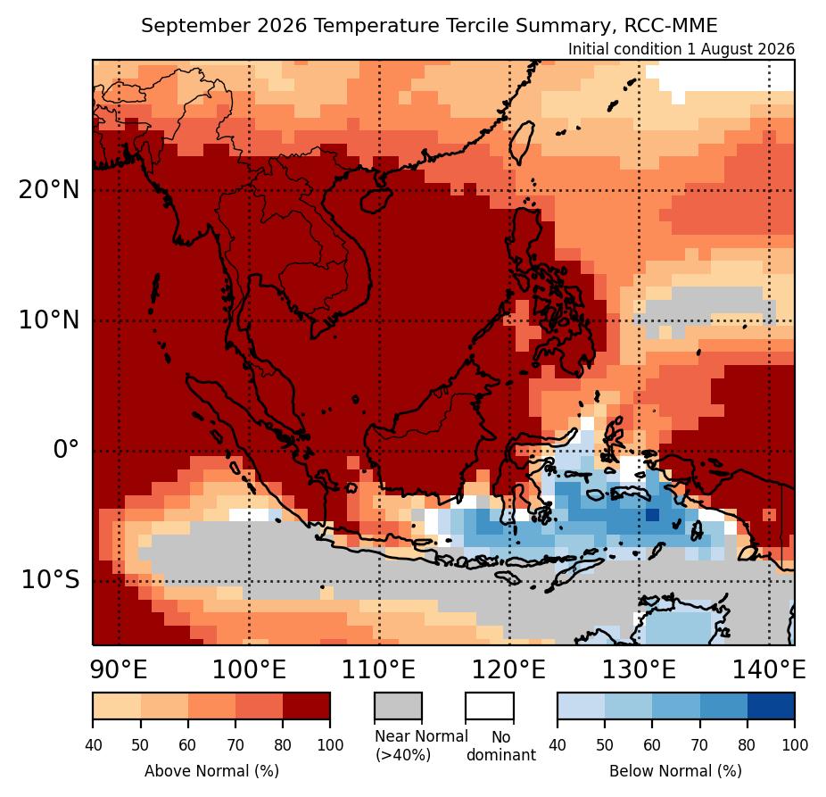
For September 2026, a high chance of above-normal temperature is predicted for most of Southeast Asia.
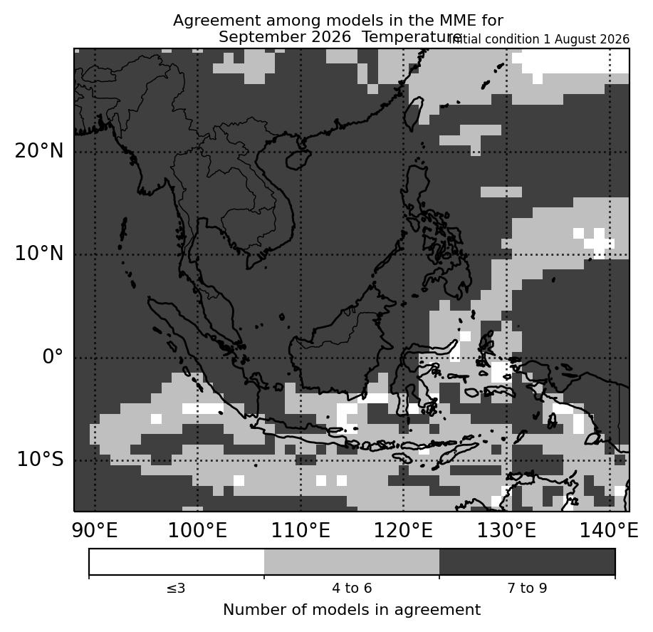
For September 2026, a high chance of above-normal temperature is predicted over most of Southeast Asia, based on the multi-model ensemble (Figure 1). The main exception is over the southern Maritime Continent where a mix of below- to above-normal temperature is predicted. For this region, much of the models agree on the most likely tercile (four to six models). Outside of southern Maritime Continent, most of the models (more than six models, Figure 2) predict above-normal as the most likely tercile. Model skill for predicting above-normal temperature is moderate to good, and good for below-normal temperature over the southern Maritime Continent.
|
|
| Figure 1: Temperature tercile summary predictions of the multi model ensemble for September 2026 (contains modified Copernicus C3S information). | Figure 2: Number of models in agreement in the multi-model ensemble for the dominant tercile for September 2026. Where there no dominant tercile, it refers to the number of models with near-normal tercile (contains modified Copernicus C3S information). |
|
|
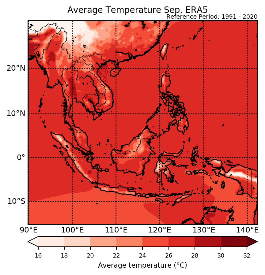
| Figure 3: Average climatological temperature for September based on ERA5 (reference period: 1991-2020). |
The qualitative outlook is assessed for the region in general. For specific updates on the national scale, the relevant ASEAN National Meteorological and Hydrological Services should be consulted. More outlook and verification plots, including for tercile and quintile probabilistic forecasts for temperature, are in the “Model products and verification: NCEP, ECMWF, UK Met Office” on the SEA-RCC Network LRF Node webpages.
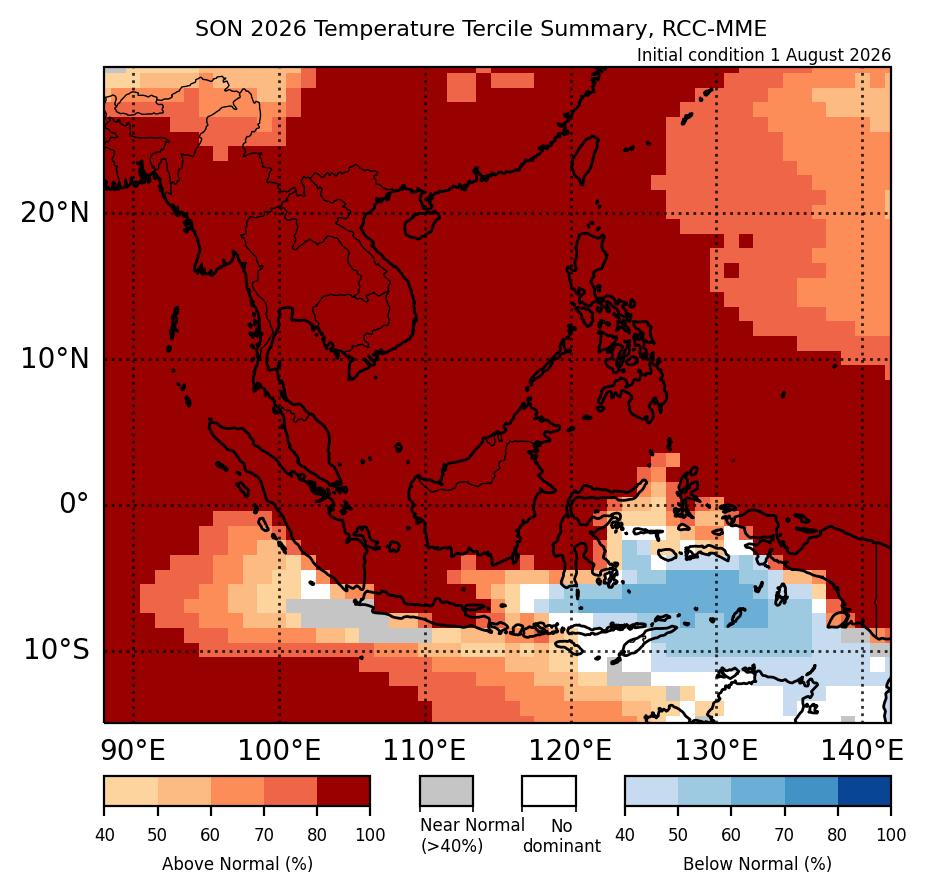
For SON 2026, models predict above-normal temperature over most of Southeast Asia.
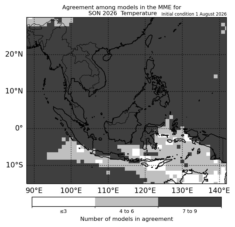
For SON 2026, above-normal temperature is predicted over most of Southeast Asia, apart from parts of the southeastern Maritime Continent where a mix of below- to above-normal temperature is predicted, based on the multi-model ensemble (Figure 1). For the southeastern Maritime Continent, much of the models agree on the most likely tercile (four to six models, Figure 2). Elsewhere, most models (more than six) are in agreement that above-normal is the most likely tercile. Model skill for predicting above-normal temperature is good at this time of the year, as well as for below-normal temperature over the southeastern Maritime Continent.
|
|
| Figure 1: Temperature tercile summary predictions of the multi model ensemble for SON 2026 (contains modified Copernicus C3S information). | Figure 2: Number of models in agreement in the multi-model ensemble for the dominant tercile for SON 2026. Where there no dominant tercile, it refers to the number of models with near-normal tercile (contains modified Copernicus C3S information). |
|
|
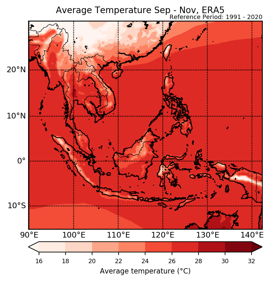
| Figure 3: Average climatological temperature for SON based on ERA5 (reference period: 1991-2020). |
The qualitative outlook is assessed for the region in general. For specific updates on the national scale, the relevant ASEAN National Meteorological and Hydrological Services should be consulted. More outlook and verification plots, including for tercile and quintile probabilistic forecasts for temperature, are in the “Model products and verification: NCEP, ECMWF, UK Met Office” on the SEA-RCC Network LRF Node webpages.
Frequently Asked Questions
What is a seasonal forecast?
A seasonal forecast provides forecast information about the general weather conditions at seasonal timescales up to several months ahead. Long range predictions rely on predicting components of the atmosphere and the oceans which show variations at large spatial and temporal scales. Among these key components is the sea-surface temperature – an important indicator in the El Niño Southern Oscillation (ENSO) cycle.

Example of probabilistic long range forecast using the multi-model ensemble. For areas nearby Peninsular Malaysia, the forecast is showing a probability of 50-70% of rainfall being in the below-normal (33%) tercile range. (Source: WMO LC LRF)
To account for the chaotic nature of the atmosphere, seasonal forecast adopts a probabilistic approach and the forecast weather condition is presented as an average over an extended period of time, usually with reference to climatology.
ASMC carries out monthly seasonal forecast predictions based on various seasonal model forecasts from the leading meteorological centres, supplemented by individual assessments from respective countries in South East Asia. The skillfulness of seasonal forecast relies greatly on the performance of seasonal models, which differ from one place to another and for different seasons of the year.

Receiver operating characteristic (ROC) score of UK GloSea5 seasonal hindcast for above-normal precipitation scenario for Dec – Feb (left) and May – Jul (right) over Asia region. Higher ROC score (indicated in red) means better model skill. (Source: UK Met Office)
For example, one way to assess the seasonal model skills is to examine the ROC score. From the figures above, we can see that ROC score map differs greatly from one season to another. During the period from Dec to Feb, a high ROC score region is observed mainly over the Philippines whereas during the period from May to Jul, a high ROC score region is observed over the near equatorial region such as Peninsular Malaysia and Sumatra.