Review of Regional Weather for August 2024
1. Overview
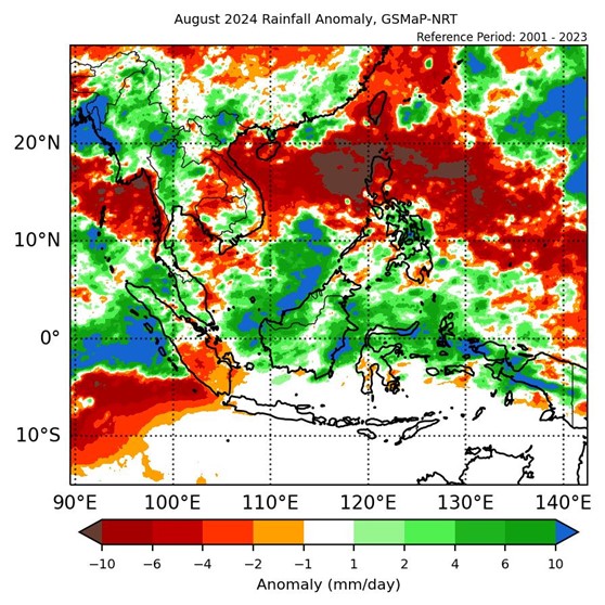
1.1 During August 2024, a mix of below- and above-average rainfall was recorded over the Southeast Asian region (Figure 1). Much of the equatorial region and northern and eastern Mainland Southeast Asia recorded above-average rainfall, while parts of eastern Mainland Southeast Asia, the Philippines, and the southern Maritime Continent recorded below-average rainfall. The largest positive (wetter) anomalies were recorded over the western coast of Myanmar and parts of Borneo based on GSMaP-NRT (Figure 1, left) and CMORPH-Blended (Figure 1, right) satellite-derived rainfall estimates. In contrast, the largest negative (drier) anomalies were recorded over the northern Philippines, central Viet Nam and southern Lao PDR (in both GSMaP-NRT and CMORPH-Blended) and Cambodia (CMORPH-Blended only).
1.2 The observed rainfall anomaly pattern of above-average rainfall over the equatorial region and a mix of below- and above-average rainfall elsewhere are broadly consistent with the predictions from the subseasonal weather outlooks for August 2024 (5 – 18 August 2024 and 19 August – 1 September 2024).
1.3 Above-average temperatures were recorded over most of Southeast Asia in August 2024, apart from over the equatorial region where near- to above-average temperatures were recorded and northern and western Mainland Southeast Asia where below-to above average temperatures were recorded (Figure 2). The regions where below- and near-average temperatures were recorded are in line with those with above-average rainfall. The coolest anomalies were over northern Lao PDR (around 1°C below average), while the warmest anomalies (more than 2°C above average) were recorded over southern Sumatra.
2. Climate Drivers
2.1 A Madden-Julian Oscillation (MJO) signal strengthened over the Western Hemisphere (Phase 1) in the second week of August, after no discernible signal for much of the first week based on the RMM index (Figure 3). This signal propagated eastward for the rest of August, reaching the Indian Ocean (Phase 2) in the third week, and the Maritime Continent (Phase 4) in the last week. Typically for August, Phases 1 and 2 tend to bring drier conditions to northeastern Southeast Asia, while Phases 2 and 3 bring wetter conditions to the western Maritime Continent, and Phase 4 brings wetter conditions to northern parts of the Maritime Continent. MJO activity therefore likely contributed to the above-average rainfall in the equatorial region, and drier conditions over parts of eastern Mainland Southeast Asia and the Philippines.
2.2 The tropical Pacific was in an ENSO neutral state during August.


