Review of Regional Weather for November 2024
1. Overview
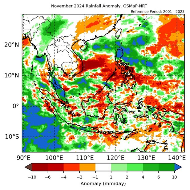
1.1 During November 2024, the ASEAN region experienced a mix of below- and above-average rainfall. For the Maritime Continent, much of the western half experienced above-average rainfall while the eastern half experienced a mix of below- to above-average rainfall (Figure 1). For Mainland Southeast Asia, above-average rainfall was recorded over parts of central and northern Myanmar and southern Thailand, with below-average rainfall over parts of eastern Mainland Southeast Asia and near-average rainfall elsewhere, although there is disagreement over central Viet Nam with GSMaP-NRT (Figure 1, left) recording below-average rainfall, while CMORPH-Blended (Figure 1, right) recorded above-average rainfall. The largest positive (wetter) anomalies were recorded over the Malay Peninsula, while the largest negative (drier) anomalies were recorded over southeastern Viet Nam and central Philippines in both GSMaP-NRT and CMORPH-Blended.
1.2 The observed rainfall anomaly pattern of a mix of below- and above-average rainfall in the ASEAN region, with above-average rainfall over the western Maritime Continent is consistent with the predictions from the subseasonal weather outlooks for November 2024 (28 October – 10 November 2024, 11 – 24 November 2024), and 25 November – 8 December 2024).
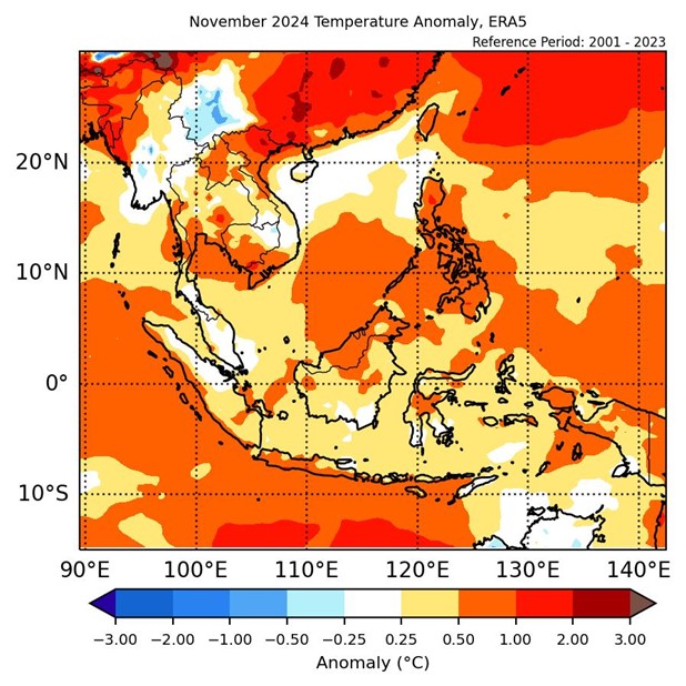
1.3 Above-average temperatures were recorded over much of the ASEAN region in November 2024 (Figure 2), with below-average temperatures recorded over a few scattered points of Mainland Southeast Asia. The warmest anomalies (more than 1°C above average) were recorded mainly over northern Viet Nam based on ERA-5 reanalysis.
2. Climate Drivers
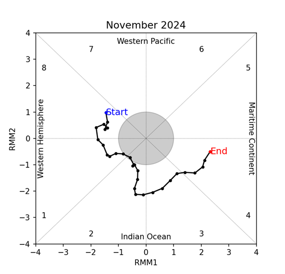
2.1 The Madden-Julian Oscillation (MJO) was active from the beginning of the first week of November 2024, based on the RMM index (Figure 3). An MJO signal was present over the Western Hemisphere (Phases 8 and 1) during the first week of November, which weakened for a short period towards the end of week 2 as it propagated eastwards. During the third week, the MJO signal emerged and remained active over the Indian Ocean (Phases 2 and 3), and propagated eastwards to the Maritime Continent (Phase 4) during the last week of the month. Phases 8 and 1 typically bring drier conditions for much of Southeast Asia during this time of the year. For November, Phases 2 and 3 tend to bring wetter conditions to the western Maritime Continent (in line with Figure 1), and Phase 4 tends to bring wetter conditions to the Maritime Continent.
2.2 In November, there were signs of La Niña-like conditions. The Nino3.4 index was approaching the La Niña threshold in October, and cool subsurface temperature anomalies in the central and eastern Pacific indicated La Niña-like conditions. However, westerly wind anomalies in the eastern tropical Pacific region during early November likely slowed the cooling process of the sea surface temperatures.


