Review of Regional Weather for January 2026
1. Overview
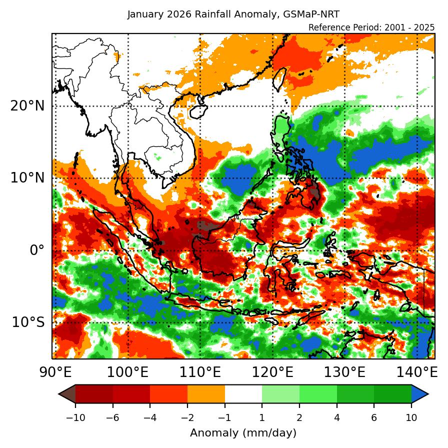
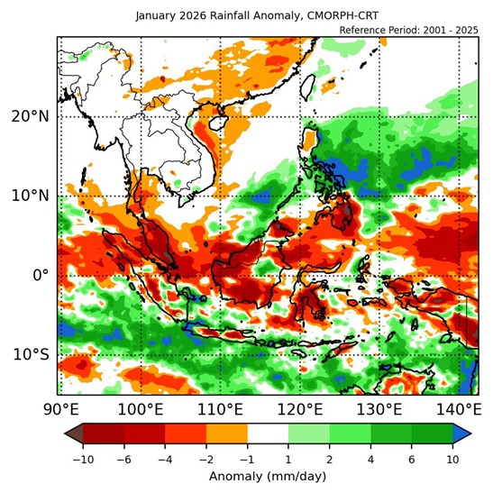
1.1 During January 2026, below- to near-average rainfall was recorded over much of the Maritime Continent with near-average rainfall over Mainland Southeast Asia (Figure 1). For the Maritime Continent, most of the equatorial region recorded below-average (drier) anomalies, with scattered spots of near- to above-average (wetter) anomalies for the southern and northeastern regions for both datasets (GSMaP-NRT and CMORPH-CRT). There were no notable anomalies over Mainland Southeast Asia, in line with the current dry season. The largest positive (wetter) anomalies were recorded over central Philippines, with the largest negative (drier) anomalies over western Borneo.
1.2 The observed rainfall anomaly pattern of below-average rainfall over much of the equatorial region and the above-average rainfall over northeast Maritime Continent is consistent with the predictions from the subseasonal weather outlooks for January 2025 (22 December 2025 – 4 January 2026, 5 – 18 January 2025, and 19 January – 1 February 2026). The observations match the most likely tercile from the seasonal outlook for January 2026 for central and northeastern Maritime Continent where the rainfall observed the largest drier and wetter anomalies, but differ for much of the rest of the Maritime Continent.
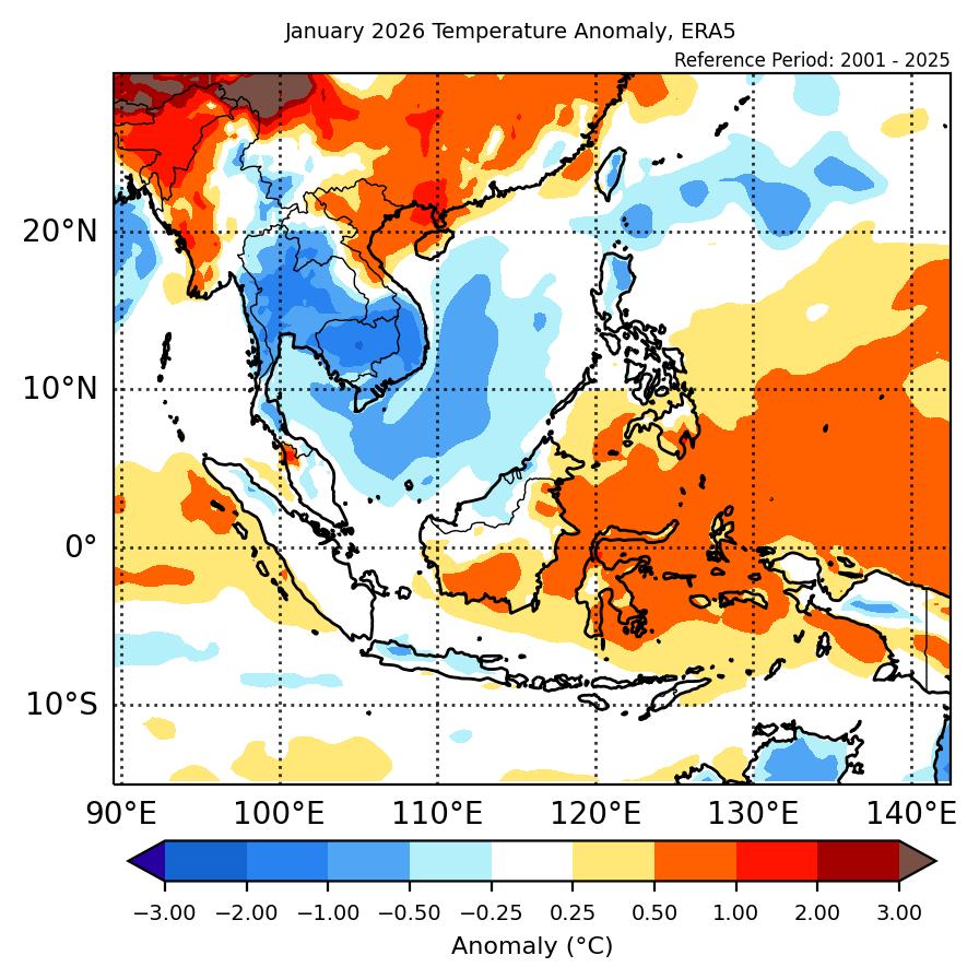
1.3 Above-average temperature was recorded over the eastern Maritime Continent and parts of northern Mainland Southeast Asia, while below-average temperature was recorded over central and southern Mainland Southeast Asia, with near-average temperature for much of the rest of Southeast Asia (Figure 2). The warmest anomalies (1°C – 2°C above average) were recorded over western Myanmar, while the coolest anomalies (1°C – 2°C below average) were recorded over Cambodia, southern Viet Nam and central Thailand.
2. Climate Drivers
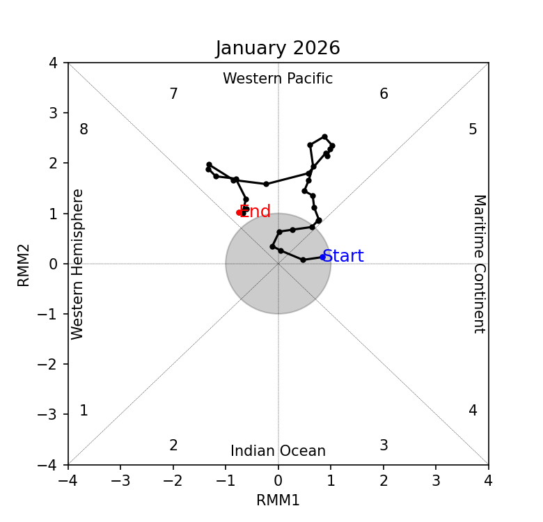
2.1 At the start of January, the Madden-Julian Oscillation (MJO) was inactive based on the RMM diagram (Figure 3). The signal emerged over the Western Pacific (Phase 6) in Week 2, strengthening with little eastward propagation in Phase 6 until middle of Week 3 when it weakened slightly and started again propagating eastwards. By Week 4, the MJO signal was in Phase 7 of the Western Pacific where it stalled and weakened at the end of the month. At this time of the year, Phases 6 and 7 tend to bring drier conditions to the western and southern Maritime Continent, in line with the observed rainfall in January also showing drier conditions for much of the Maritime Continent.
2.2 La Niña conditions persisted in January 2026, although key atmospheric indicators show signs of the La Niña conditions weakening. La Niña events tend to bring wetter-than-average conditions to much of the Maritime Continent during this time of the year. The Indian Ocean Dipole (IOD) is currently in the neutral state.