Monthly Archives: September 2019

September 30, 2019

Outlook for Land Fires and Smoke Haze Situation (1 – 15 October 2019)

Outlook for Land Fires and Smoke Haze Situation (1 – 15 October 2019)

Issued 30 September 2019

Wetter-than-normal conditions over the equatorial region, including northern Sumatra and parts of Kalimantan, are expected to help subdue hotspot activities there. However, hotspot activities may persist in other areas where the weather is expected to be dry.

In the northern ASEAN region, hotspot activities are likely to remain generally subdued.

Subseasonal Weather Outlook (1 – 15 October 2019)

Subseasonal Weather Outlook (1 – 15 October 2019)

Issued 30 September 2019
Valid for weeks 1 and 2: 1 October – 15 October

figure1

Figure 1: Rainfall Outlook
figure2

Figure 2: Temperature Outlook

Drier conditions can be expected over most parts of the ASEAN region in the first fortnight of October 2019. However, wetter conditions are forecast over the equatorial ASEAN region, including northern Sumatra, Peninsular Malaysia, Sarawak, and Kalimantan in the first week under the influence of the Madden – Julian Oscillation (MJO), which is currently in Phase 1. The MJO is forecast to weaken during the first week.

Warmer-than-average conditions are also expected to prevail over much of the Mekong sub-region.

The outlook is assessed for the region in general. For specific updates on the national scale, the relevant ASEAN National Meteorological and Hydrological Services should be consulted.

Review of Regional Weather Conditions for First Fortnight of September 2019

Review of Regional Weather Conditions for First Fortnight of September 2019

Print Version

1. Review of Regional Weather Conditions for First Fortnight of September 2019

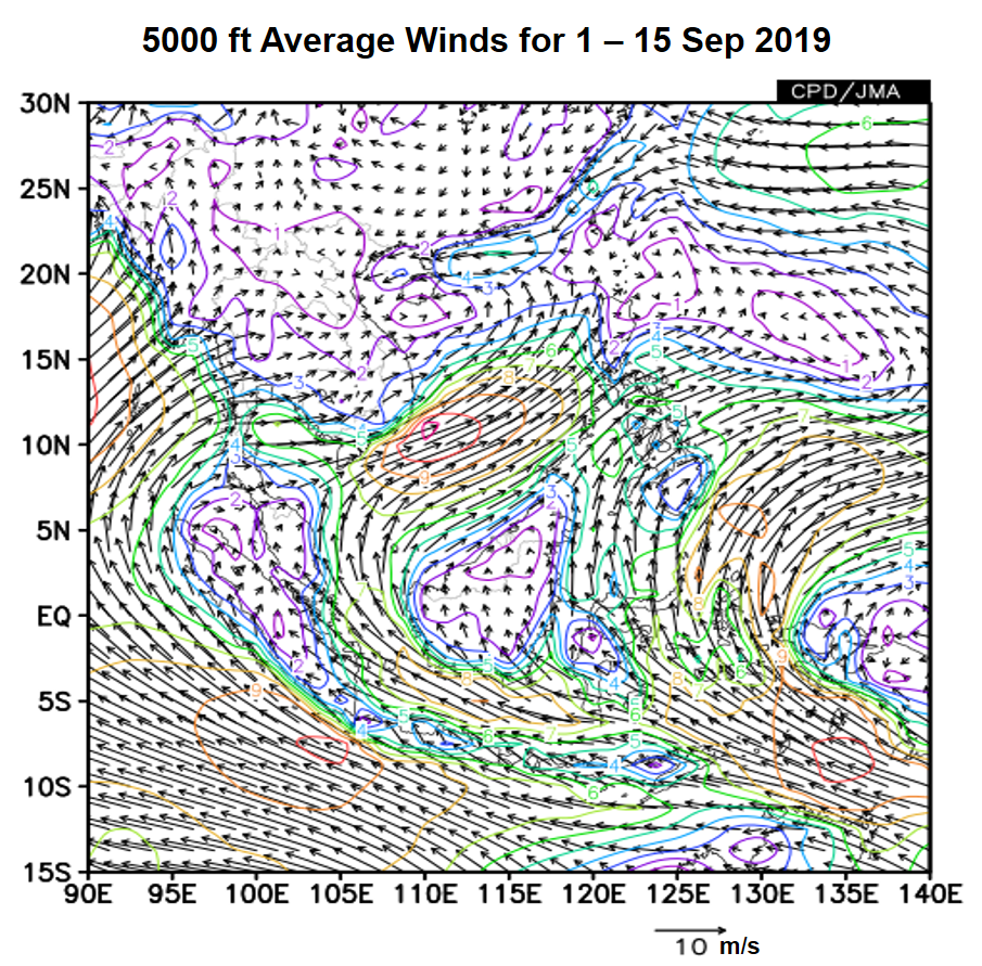
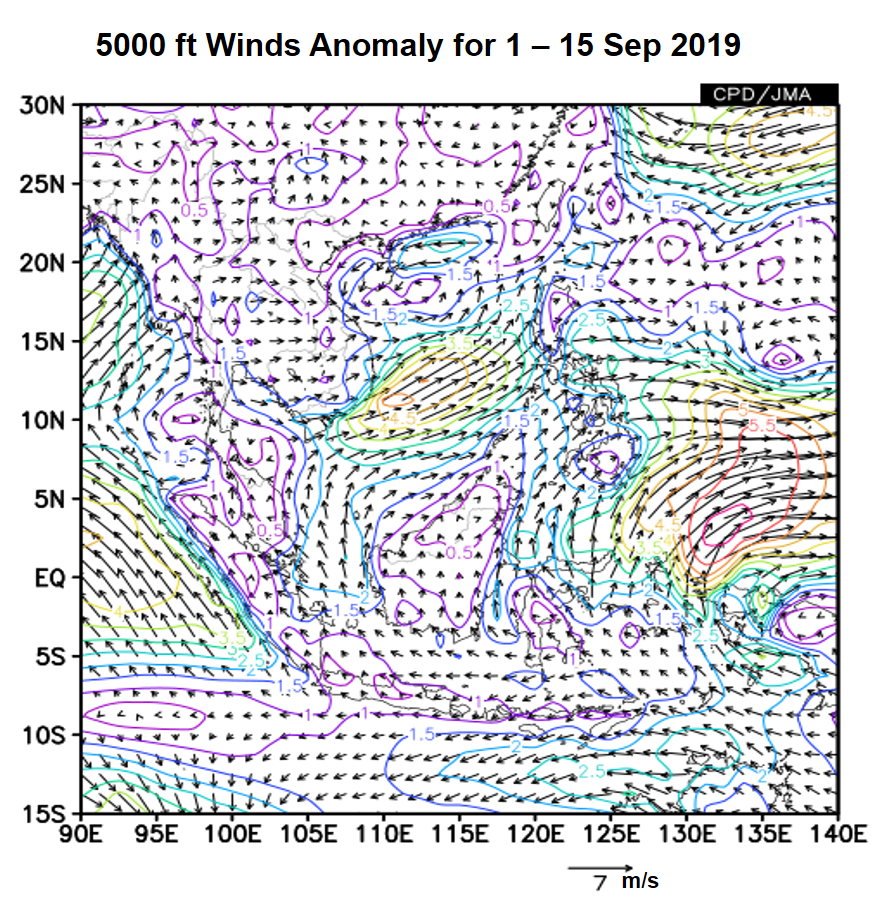
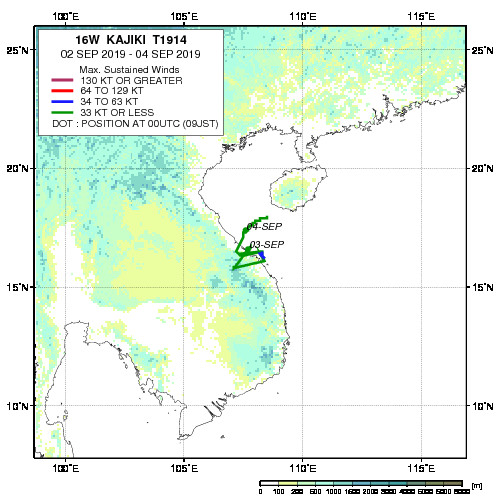
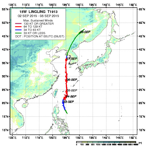
1.1 In the first fortnight of September 2019, weak to moderate southwesterly or westerly winds prevailed over most parts of the northern ASEAN region (Figure 1). Anomalously strong southwesterly winds were observed to the east of Viet Nam and southeast of the Philippines due to the influence of Tropical Storm Kajiki and Typhoon Lingling (Figure 2). In the southern ASEAN region, the prevailing winds blew mainly from the southeast or southwest.

figure1a
figure1b

Figure 1: 5000 ft average winds (left) and anomalies (right) for 1 – 15 September 2019 (Source: JMA)

figure1a
figure1b

Figure 2: Historical track of Tropical Storm Kajiki (left) and Typhoon Lingling (right). (Source: JAXA)

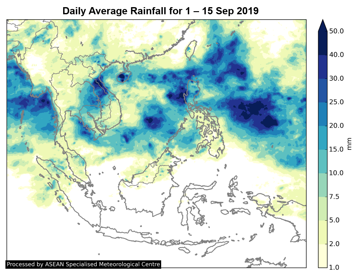
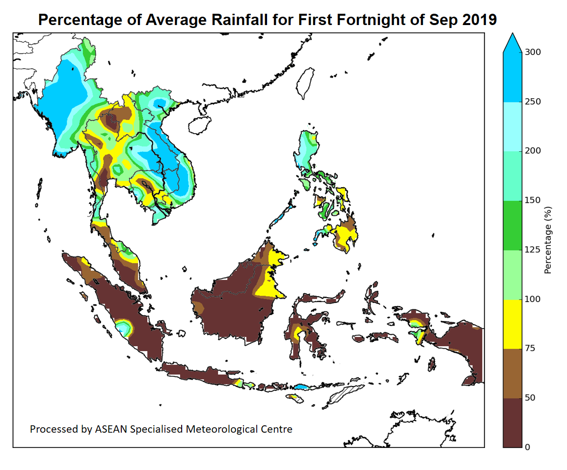
1.2 Southwest Monsoon conditions prevailed in the first half of September 2019. Much of the northern ASEAN region received above-average rainfall except for some areas in Cambodia and Thailand. In the southern ASEAN region, below-average rainfall was observed over many areas (Figures 3 and 4).

figure2

Figure 3: Daily average rainfall for the ASEAN region in the first fortnight of September 2019 (Source: JAXA Global Satellite Mapping of Precipitation)

Figure 4: Percent of average rainfall for 1 – 15 September 2019. The rainfall data may be less representative for areas with a less dense rainfall network. (Source: IRI NOAA/NCEP CPC Unified Precipitation Analyses)

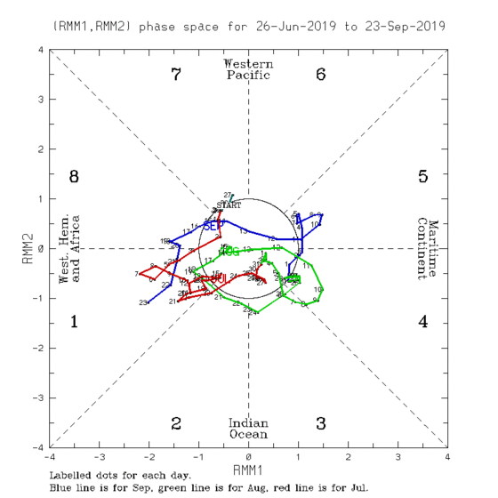
1.3 Throughout the first fortnight of September 2019, the Madden-Julian Oscillation (MJO) remained weak based on the RMM index and did not significantly influence the weather over the ASEAN region (Figure 5).

Figure 5: The MJO phase diagram for Sep 2019 (blue). The diagram illustrates the movement of the MJO through different phases, which correspond to different locations along the equator. The distance of the index from the centre of the diagram is correlated with the strength of MJO. When the index falls within the circle, the MJO is considered weak or indiscernible. (Source: Bureau of Meteorology)

1.4 The state of the El Niño-Southern Oscillation (ENSO) is currently neutral (neither El Niño nor La Niña), and the sea-surface temperatures (SST) over the tropical Pacific Ocean continue to show a cooling trend. An Indian Ocean-related index, known as the Indian Ocean Dipole (IOD), is observed to be in the positive phase, as colder-than-average sea surface temperatures continue to be present over the eastern Indian Ocean. The positive IOD has contributed to the drier conditions over the southern ASEAN region during the first fortnight of September 2019.

Review of Land Fires and Smoke Haze Situation for First Fortnight of September 2019

Review of Land Fires and Smoke Haze Situation for First Fortnight of September 2019

1.1 Under prevailing wet conditions, no significant hotspot activity was observed in the northern ASEAN region.

1.2 In the southern ASEAN region, prolonged dry weather in the first fortnight of September 2019 led to the significant increase in the hotspot activities, particularly over Sumatra and Kalimantan. Widespread moderate to dense smoke haze was observed to emanate from persistent hotspots detected in Sumatra and Kalimantan, and hazy conditions had shrouded many areas there during the fortnight period. Some of the smoke haze from Sumatra and Kalimantan had also been blown by the prevailing winds to affect Malaysia and Singapore.

Figure 1: Himawari-8 satellite image on 8 Sep 2019 shows smoke haze from hotspots detected in West, Central and South Kalimantan; some of the smoke haze had been blown toward the adjacent sea areas and western Sarawak.

Figure 2: Himawari-8 satellite image on 10 Sep 2019 shows smoke haze from hotspots detected in southern and central Sumatra; some of the smoke haze had been transported to affect Peninsular Malaysia and Singapore.

Figure 3: Aqua satellite image on 11 Sep 2019 shows widespread moderate to dense smoke haze from hotspots detected in southern and central Sumatra.

Figure 4: Aqua satellite image on 14 Sep 2019 shows widespread moderate to dense smoke haze from hotspots detected in Kalimantan.

Figure 5: The distribution of hotspots detected from 1 September to 15 September 2019 in Sumatra, Kalimantan and Malaysia, based on NOAA-20 satellite surveillance. (Source of prevailing winds: JMA)

September 29, 2019

Alert20190929 – Downgrade of Alert Level 3 to Alert Level 2 for the southern ASEAN region

Downgrade of Alert Level 3 to Alert Level 2 for the southern ASEAN region

Recent showers and a change in wind conditions have brought an improvement to the haze situation in the region. Based on surveillance by the NOAA-20 satellite, 32 and 16 hotspots were detected in Sumatra, and 22 and 137 hotspots were detected in Kalimantan on 27 and 28 September 2019 respectively. Smoke haze continued to be observed in the vicinity of hotspots in southern Sumatra and in parts of Kalimantan.

In the coming days, the prevailing winds over the southern ASEAN region are forecast to gradually weaken, and an increase in shower activities is expected. However, some parts of the region can still experience periods of dry weather, and hotspot activities may persist in some areas of Sumatra and Kalimantan.

September 20, 2019

Review of Regional Weather Conditions for Second Fortnight of August 2019

Review of Regional Weather Conditions for Second Fortnight of August 2019

Print Version

1. Review of Regional Weather Conditions for Second Fortnight of August 2019

1.1 Southwest Monsoon conditions prevailed. There were anomalously strong southwesterly winds over the northern ASEAN region in the second fortnight of August 2019. In the southern ASEAN region, winds were blowing mainly from the southeast.

figure1a
figure1b

Figure 1: 5000 ft average winds (left) and anomalies (right) for 16 – 31 August 2019 (Source: JMA)

1.2 In the second half of August 2019, rainfall was generally above average, except in Cambodia, and the southern parts of Thailand and Viet Nam. Tropical Storm Podul, which formed over the Western Pacific Ocean, made landfall in Luzon, the Philippines on 28 August 2019 before tracking westward across the South China Sea. Tropical Storm Podul weakened rapidly after making landfall at northern Viet Nam on 30 August 2019, and the storm contributed to stronger monsoon winds and above-average rainfall over the Mekong sub-region and the Philippines.

Figure 2: Historical track of Tropical Storm Podul. (Source: JAXA)

1.3 In the southern ASEAN region, drier-than-average conditions were observed over many parts of Sumatra, west coast of Peninsular Malaysia, eastern Borneo and Java. The drier-than-average conditions could be partly attributed to the presence of Indian Ocean Dipole in the positive phase.

figure2

Figure 3: Daily average rainfall for the ASEAN region in the second fortnight of August 2019 (Source: JAXA Global Satellite Mapping of Precipitation)

Figure 4: Percent of average rainfall for 16 – 31 August 2019. The rainfall data may be less representative for areas with a less dense rainfall network. (Source: IRI NOAA/NCEP CPC Unified Precipitation Analyses)

1.4 During the review period, the Madden-Julian Oscillation (MJO) propagated through the Indian Ocean and Western Maritime Continent. Although the signal was not strong (Figure 5), it might have influenced rainfall over parts of the northern ASEAN region.

Figure 5: The MJO phase diagram (green for August 2019). The diagram illustrates the movement of the MJO through different phases, which correspond to different locations along the equator. The distance of the index from the centre of the diagram is correlated with the strength of MJO. When the index falls within the circle, the MJO is considered weak or indiscernible. (Source: Bureau of Meteorology)

Review of Land Fires and Smoke Haze Situation for Second Fortnight of August 2019

Review of Land Fires and Smoke Haze Situation for Second Fortnight of August 2019

1.1 During the second fortnight of August 2019, dry weather over Sumatra and Kalimantan was interspersed with occasional shower activities. In Sumatra, there were persistent clusters of hotspots detected in the central and southern parts of the island, particularly the provinces of Riau and Jambi. Moderate to dense smoke haze was observed to emanate from some of these hotspots.

1.2 In Kalimantan, significant smoke haze from persistent hotspot activities in Central Kalimantan resulted in widespread hazy conditions over the province. Hotspots with smoke haze were also detected in West, South and East Kalimantan. On a few days, some of the smoke haze from persistent hotspots in West Kalimantan was blown by the prevailing winds toward western Sarawak by the prevailing winds.

Figure 1: Hotspots with smoke haze detected in Riau, Jambi and South Sumatra based on NOAA-20 on 19 Aug 2019.

Figure 2: Moderate to dense smoke haze detected in Riau and Jambi, Sumatra based on image from Himawari-8 satellite on 18 August 2019.

Figure 3: Widespread moderate to dense smoke haze detected in Central Kalimantan. Hotspots with smoke haze were also observed in West and East Kalimantan. Image based on Himawari-8 satellite on 16 August 2019.

September 16, 2019

ASMC Bulletin (Issue #4, Sep 2019)

ASMC Bulletin (Issue #4, Sep 2019)

September 14, 2019

Outlook for Land Fires and Smoke Haze Situation (16 – 30 September 2019)

Outlook for Land Fires and Smoke Haze Situation (16 – 30 September 2019)

Issued 14 September 2019

During this outlook period, hotspot activities in the Mekong sub-region are expected to remain generally subdued. In the southern ASEAN region, there have been occurrences of transboundary haze as a result of an escalation of hotspot activities in Sumatra and Kalimantan. With drier-than-usual and warmer conditions forecast for the coming fortnight, hotspot activities in Sumatra and Kalimantan can be expected to persist. Depending on the prevailing winds and the extent of the smoke haze there, further occurrences of transboundary haze can be expected.

Subseasonal Weather Outlook (16 – 30 September 2019)

Subseasonal Weather Outlook (16 – 30 September 2019)

Issued 14 September 2019
Valid for weeks 3 and 4: 16 September – 30 September

figure1

Figure 1: Rainfall Outlook
figure2

Figure 2: Temperature Outlook

In the second fortnight of September 2019, drier-than-usual conditions are forecast to persist over most parts of the southern ASEAN region. The positive Indian Ocean Dipole (IOD) is likely a contributing factor to the drier conditions, as colder-than-average sea surface temperatures continue to persist over the eastern Indian Ocean.

Warmer conditions are forecast to prevail over much of the southern ASEAN region, and over the northern half of the Mekong sub-region in the third week of September.

The outlook is assessed for the region in general. For specific updates on the national scale, the relevant ASEAN National Meteorological and Hydrological Services should be consulted.