Category Archives: Regional Weather Outlook for Year 2025

December 18, 2025

Subseasonal Weather Outlook (22 December 2025 – 4 January 2026)

Subseasonal Weather Outlook (22 December 2025 – 4 January 2026)

Issued: 3 December 2025
First forecast week: 22 – 28 December 2025
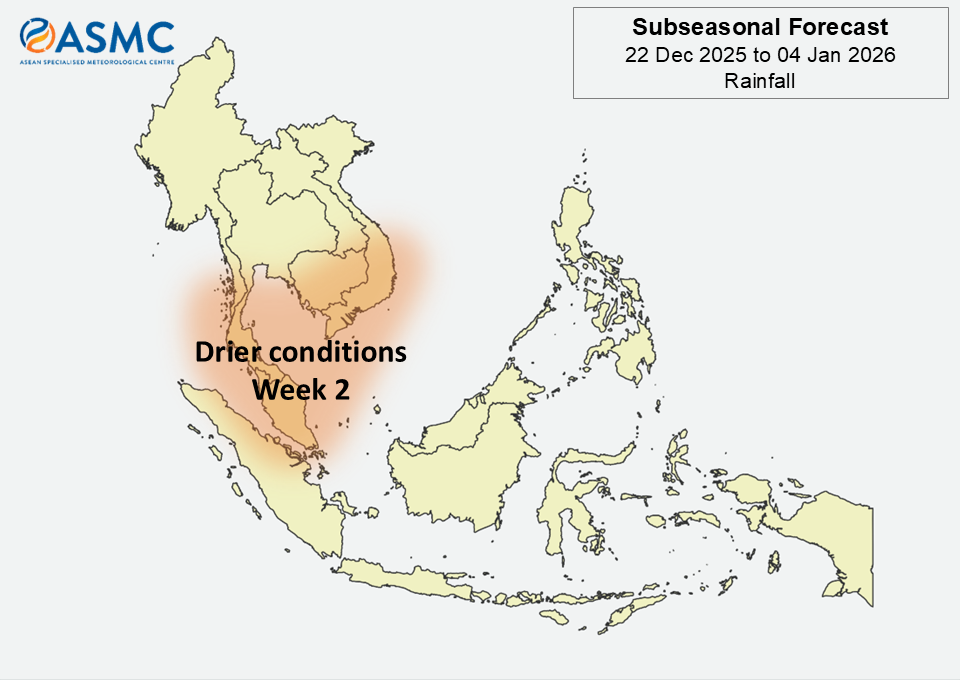
Second forecast week: 29 December 2025 – 4 January 2026

figure1

Figure 1: Rainfall Outlook

figure2

Figure 2: Temperature Outlook

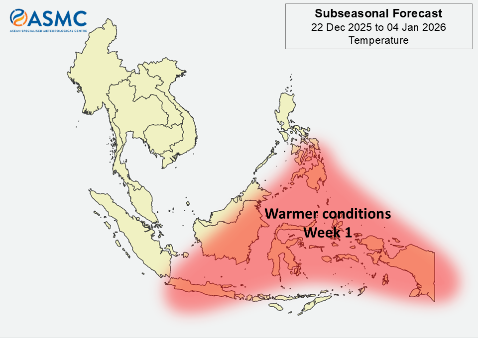
Warmer than usual temperature is predicted in Week 1 (22 – 28 Dec 2025) over much of the eastern and southern Maritime Continent.

Drier than usual conditions for this time of the year are predicted​ over parts of the western Maritime Continent and southern Mainland Southeast Asia in Week 2 (29 Dec 2025 – 4 Jan 2026).
​​
There was no Madden-Julian Oscillation (MJO) signal present by the middle of December 2025, based on the RMM Index. Most models predict no sustained MJO signal during the forecast period (22 Dec 2025 – 4 Jan 2026).

The outlook is assessed for the region in general, where conditions are relative to the average conditions for the corresponding time of year. For specific updates on the national scale, the relevant ASEAN National Meteorological and Hydrological Services should be consulted.

December 17, 2025

Subseasonal Weather Outlook (8 – 21 December 2025)

Subseasonal Weather Outlook (8 – 21 December)

Issued: 3 December 2025
First forecast week: 8 – 14 December 2025
Second forecast week: 15 – 21 December 2025

figure1

Figure 1: Rainfall Outlook

figure2

Figure 2: Temperature Outlook

For Mainland Southeast Asia in Week 1 (8 – 14 December), wetter conditions are predicted over parts of the eastern portion.

For the Maritime Continent in Week 1 (8 – 14 December), wetter conditions are predicted over parts of the northeastern and southeastern portions, while drier conditions are predicted over much of the rest of the Maritime Continent.

Cooler than usual temperatures are predicted for much of the southern Maritime Continent in Week 1 (8 – 14 December).

A strong Madden-Julian Oscillation (MJO) signal was present over the Western Pacific (Phase 7) at the start of December, based on the RMM index. Models predict this signal to weaken rapidly and become indiscernible by the start of the forecast period. Some models* predict an MJO signal to emerge towards the end of Week 1 (8 – 14 December) in the Western Hemisphere and Africa (Phase 8) and then propagate slowly eastwards in Week 2 (15 – 21 December).

The outlook is assessed for the region in general, where conditions are relative to the average conditions for the corresponding time of year. For specific updates on the national scale, the relevant ASEAN National Meteorological and Hydrological Services should be consulted.

November 19, 2025

Subseasonal Weather Outlook (24 November – 7 December 2025)

Subseasonal Weather Outlook (24 November – 7 December)

Issued: 19 November 2025
First forecast week: 24 – 30 November 2025
Second forecast week: 1 – 7 December 2025

figure1

Figure 1: Rainfall Outlook

figure2

Figure 2: Temperature Outlook

Drier conditions are predicted over much of Mainland Southeast Asia in Week 1 (24 – 30 November). Drier conditions are also predicted over the southern Maritime Continent in Week 2 (1 – 7 December).

Wetter conditions are predicted over parts of the western Maritime Continent in Week 1 (24 – 30 November).

Cooler than usual temperatures are predicted over much of Mainland Southeast Asia in Week 1 (24 – 30 November).

A Madden-Julian Oscillation (MJO) signal was present in the Western Pacific (Phase 6) during the middle of November, based on the RMM index. Most models predict an MJO signal to propagate from Phase 6 to Phase 7 during the forecast period (24 November – 7 December).

The outlook is assessed for the region in general, where conditions are relative to the average conditions for the corresponding time of year. For specific updates on the national scale, the relevant ASEAN National Meteorological and Hydrological Services should be consulted.

November 5, 2025

Subseasonal Weather Outlook (10 – 23 November 2025)

Subseasonal Weather Outlook (10 – 23 November 2025)

Issued: 5 November 2025
First forecast week: 10 – 16 November 2025
Second forecast week: 17 – 23 November 2025

figure1

Figure 1: Rainfall Outlook

figure2

Figure 2: Temperature Outlook

Drier conditions are predicted over southern and southeastern Mainland Southeast Asia and the western equatorial region in Week 1 (10 – 16 November).

Wetter conditions are predicted over much of the southern and southeastern Maritime Continent in the next fortnight (10 – 23 November). Wetter conditions are also predicted over southern and southeastern Mainland Southeast Asia in Week 2 (17 – 23 November).

Warmer than usual temperatures are predicted over parts of the western and central equatorial region in the next fortnight (10 – 23 November). Cooler than usual temperatures are predicted over parts of Mainland Southeast Asia in Week 2 (17 – 23 November).

A Madden-Julian Oscillation (MJO) signal propagated across the Maritime Continent (Phases 4 and 5) during the last week of October. Most models predict this signal to reach the Western Pacific (Phase 6) by the start of the forecast period and then continue propagating eastwards. Some models predict the signal to weaken over the Western Pacific (Phase 7) in Week 2 (17 – 23 November).

The outlook is assessed for the region in general, where conditions are relative to the average conditions for the corresponding time of year. For specific updates on the national scale, the relevant ASEAN National Meteorological and Hydrological Services should be consulted.

October 27, 2025

Subseasonal Weather Outlook (27 October – 9 November 2025)

Subseasonal Weather Outlook (27 October – 9 November 2025)

Issued: 23 October 2025
First forecast week: 27 October – 2 November 2025
Second forecast week: 3 – 9 November 2025

figure1

Figure 1: Rainfall Outlook

figure2

Figure 2: Temperature Outlook

Wetter conditions are predicted over southeastern Mainland Southeast Asia in Week 1 (27 October – 2 November). Wetter conditions are also predicted over most of the southern Maritime Continent in the next fortnight (27 October – 9 November).

Drier conditions are predicted over the western and central equatorial region in Week 1 (27 October – 2 November).

Warmer than usual temperatures for this time of the year are predicted over the western and central equatorial region in Week 1 (27 October – 2 November), in line with the predicted drier conditions. Warmer than usual temperatures are also predicted over western Mainland Southeast Asia in Week 1.

A Madden-Julian Oscillation (MJO) signal was present over the Indian Ocean (Phase 2) in the middle of October. Models predict continued eastward propagation of the MJO signal to the Maritime Continent (Phase 4) by the start of the forecast period. For Week 1 (27 October – 2 November), models predict the MJO to weaken over the Maritime Continent (Phases 4 and 5), with some predicting the signal to continue propagating over the Western Pacific (Phases 6 and 7) in Week 2 (3 – 9 November).

The outlook is assessed for the region in general, where conditions are relative to the average conditions for the corresponding time of year. For specific updates on the national scale, the relevant ASEAN National Meteorological and Hydrological Services should be consulted.

October 8, 2025

Subseasonal Weather Outlook (13 – 26 October 2025)

Subseasonal Weather Outlook (13 – 26 October 2025)

Issued: 8 October 2025
First forecast week: 13 – 19 October 2025
Second forecast week: 20 – 26 October 2025

figure1

Figure 1: Rainfall Outlook

figure2

Figure 2: Temperature Outlook

Wetter conditions are predicted over most of the southern Maritime Continent in the next fortnight (13 – 26 October).

Warmer than usual temperatures for this time of the year are predicted over northern Mainland Southeast Asia in Week 1 (13 – 19 October).

There was no significant Madden-Julian Oscillation (MJO) activity in the first week of October. Most models predict development of an MJO signal over the Western Hemisphere and Africa (Phases 8 and 1) near the start of the forecast period, propagating to the Indian Ocean (Phase 2) in Week 1 (13 – 19 October). Some models predict the signal to continue propagating and reach the Maritime Continent (Phase 4) in Week 2 (20 – 26 October).

The outlook is assessed for the region in general, where conditions are relative to the average conditions for the corresponding time of year. For specific updates on the national scale, the relevant ASEAN National Meteorological and Hydrological Services should be consulted.

September 24, 2025

Subseasonal Weather Outlook (29 September – 12 October 2025)

Subseasonal Weather Outlook (29 September – 12 October 2025)

Issued: 24 September 2025
First forecast week: 29 September – 5 October 2025
Second forecast week: 6 – 12 October 2025

figure1

Figure 1: Rainfall Outlook

figure2

Figure 2: Temperature Outlook

Wetter conditions are predicted over much of the central and southern Maritime Continent in the next fortnight (29 September – 12 October).

No significant regional temperature anomalies are predicted in the next fortnight (29 September – 12 October).

No significant Madden-Julian Oscillation (MJO) signal was present in the third week of September. Most models predict no significant MJO activity during the forecast period. Subseasonal Weather Outlook (15 – 28 September 2025)

The outlook is assessed for the region in general, where conditions are relative to the average conditions for the corresponding time of year. For specific updates on the national scale, the relevant ASEAN National Meteorological and Hydrological Services should be consulted.

September 10, 2025

Subseasonal Weather Outlook (15 – 28 September 2025)

Subseasonal Weather Outlook (15 – 28 September 2025)

Issued: 10 September 2025
First forecast week: 15 – 21 September 2025
Second forecast week: 22 – 28 September 2025

figure1

Figure 1: Rainfall Outlook

figure2

Figure 2: Temperature Outlook

Wetter conditions are predicted over much of the equatorial region and southwestern Maritime Continent in the next fortnight (15 – 28 September).

Drier conditions are predicted over central and northeastern Mainland Southeast Asia in Week 1 (15 – 21 September).

Cooler than usual temperatures are predicted in Week 1 (15 – 21 September) over the southwestern Maritime Continent and parts of the central equatorial region.

No coherent Madden-Julian Oscillation (MJO) signal was present at the start of September.
Most models predict no significant MJO activity during the forecast period.

The outlook is assessed for the region in general, where conditions are relative to the average conditions for the corresponding time of year. For specific updates on the national scale, the relevant ASEAN National Meteorological and Hydrological Services should be consulted.

August 28, 2025

Subseasonal Weather Outlook (1 – 14 September 2025)

Subseasonal Weather Outlook (1 – 14 September 2025)

Issued: 27 August 2025
First forecast week: 1 – 7 September 2025
Second forecast week: 8 – 14 September 2025

figure1

Figure 1: Rainfall Outlook

figure2

Figure 2: Temperature Outlook

Wetter conditions are predicted over much of the equatorial region in Week 2 (8 – 14 September).

No significant regional temperature anomalies are predicted in the next fortnight (1 – 14 September).

A Madden-Julian Oscillation (MJO) signal propagated from the Indian Ocean (Phases 2 and 3) towards the Maritime Continent (Phase 4) in the second half of August. Most models predict this signal to decay by the start of September, with no significant MJO activity predicted during the forecast period.

The outlook is assessed for the region in general, where conditions are relative to the average conditions for the corresponding time of year. For specific updates on the national scale, the relevant ASEAN National Meteorological and Hydrological Services should be consulted.

August 14, 2025

Subseasonal Weather Outlook (18 – 31 August 2025)

Subseasonal Weather Outlook (18 – 31 August 2025)

Issued: 14 August 2025
First forecast week: 18 – 24 August 2025
Second forecast week: 25 – 31 August 2025

figure1

Figure 1: Rainfall Outlook

figure2

Figure 2: Temperature Outlook

Drier conditions are predicted over parts of the western Maritime Continent in Week 1 (18 – 24 August). Warmer than usual temperatures are predicted over the same area in the next fortnight (18 – 31 August).

In Week 1 (18 – 24 August), wetter conditions and cooler than usual temperatures are predicted over parts of the southern and eastern Maritime Continent.

A weak Madden-Julian Oscillation (MJO) signal propagated from the Western Hemisphere and Africa (Phases 8 and 1) towards the Indian Ocean in the first week of August. Most models predict this signal to continue propagating over the Indian Ocean (Phases 2 and 3), then weaken and become indiscernible in Week 1. Models disagree if the MJO signal will reach the Maritime Continent (Phase 4) before decaying.

The outlook is assessed for the region in general, where conditions are relative to the average conditions for the corresponding time of year. For specific updates on the national scale, the relevant ASEAN National Meteorological and Hydrological Services should be consulted.