Category Archives: Haze Review

CR58

September 14, 2026

Review of Regional Haze Situation for August 2026

Review of Regional Haze Situation for August 2026

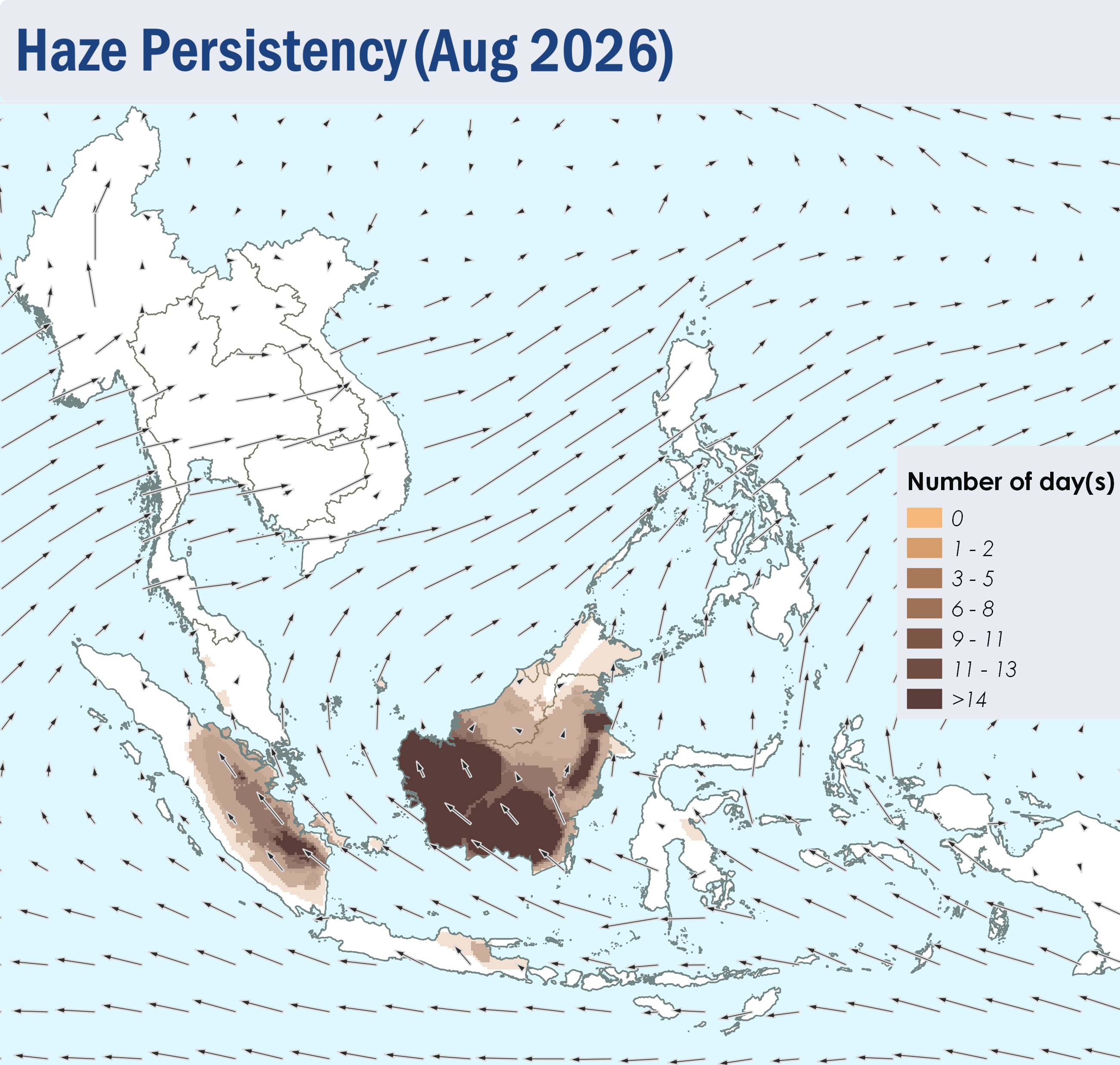
1.1 During August 2026, the ASEAN region continued to experience the Southwest Monsoon conditions. The prevailing winds over the southern ASEAN region blew from the southeast or south, while the prevailing winds over the northern ASEAN region blew from the southwest to west (Figure 1).

1.2 Dry weather was observed over most of the southern ASEAN region during the review period, except for some showers over the northern parts of Peninsular Malaysia and Sumatra, and the northeastern parts of Borneo (Figure 1). Alert Levels 2 and 3 for the southern ASEAN region were raised on 3 August 2026 and 26 August 2026 respectively, in view of an increased risk of transboundary haze occurrence, amid persistent dry weather and an escalating hotspot and smoke haze situation. On the other hand, showers prevailed over the northern ASEAN region (Figure 1).
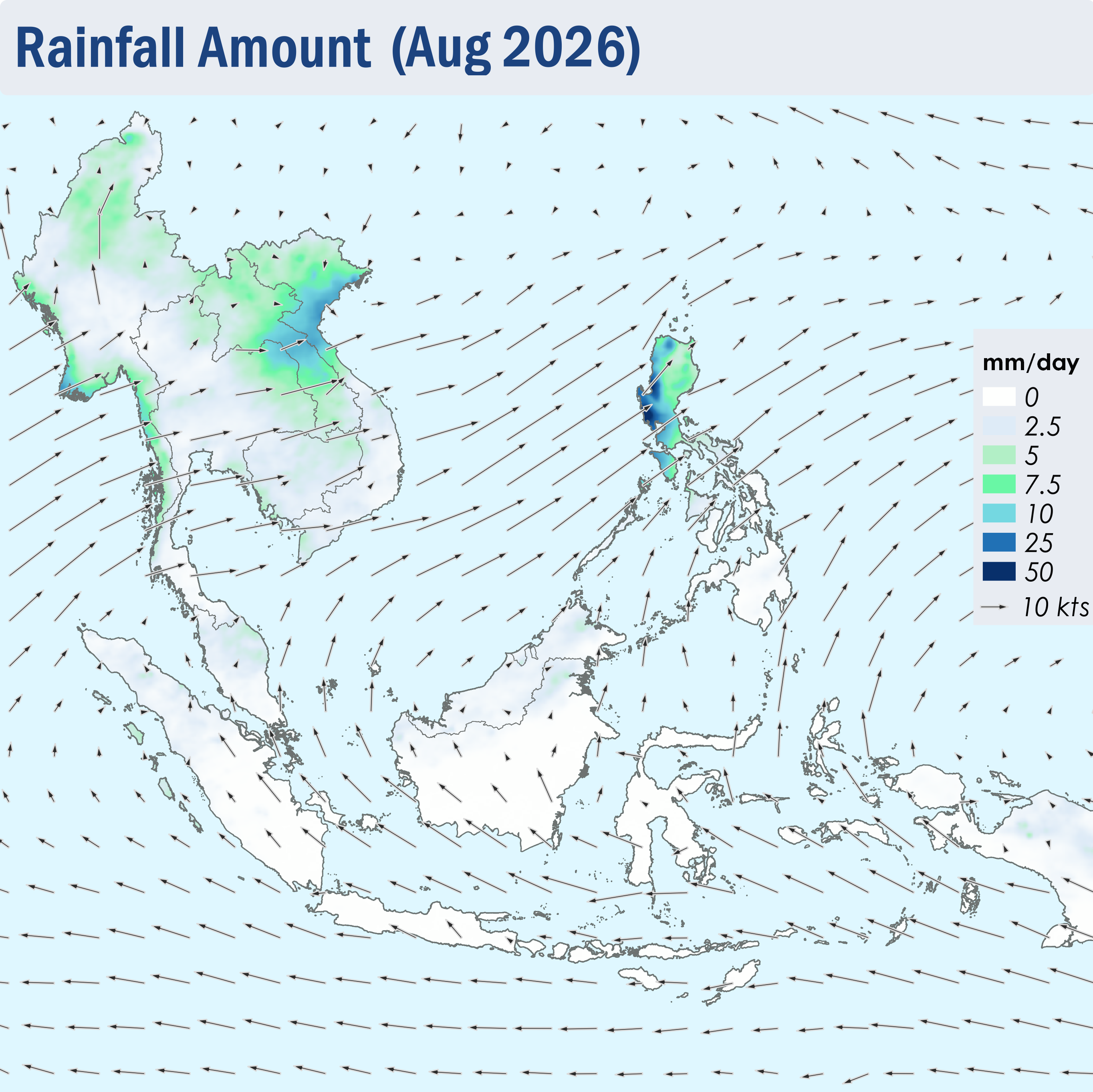
Figure 1: Average Daily Rainfall and Mean Winds for August 2026. (Source: JAXA GsMaP and GFS, respectively)


1.3 Over the southern ASEAN region, hotspot counts were mostly higher in August 2026 compared to previous years, with Kalimantan, Sumatra, Sabah and Sarawak having the highest counts recorded in five years (Figure 2). Over the northern ASEAN region, the hotspot counts for August 2026 were generally lower or comparable to previous years, except over the Philippines where the hotspot count was the highest recorded in five years (Figure 3).
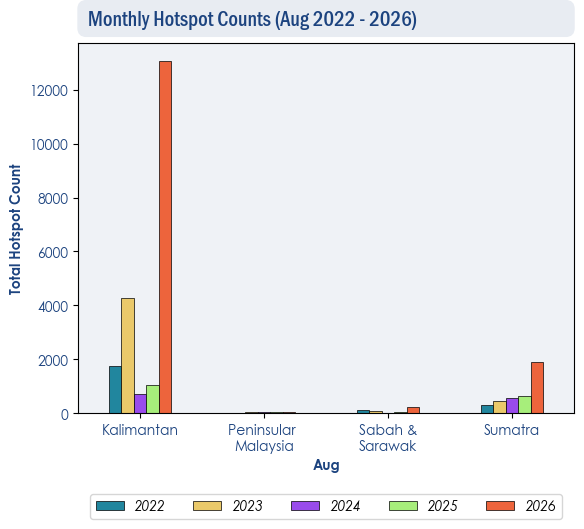
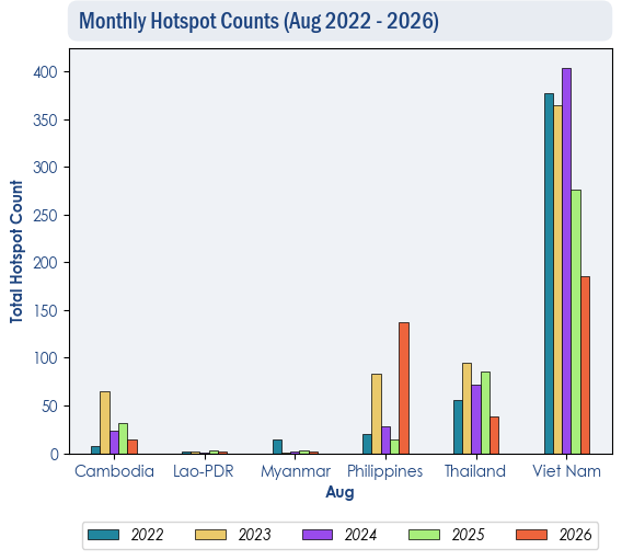
Figure 2: Hotspot counts for the southern ASEAN region for August (2022-2026) based on NOAA-20 satellite surveillance.


Figure 3: Hotspot counts for the northern ASEAN region for August (2022-2026) based on NOAA-20 satellite surveillance.


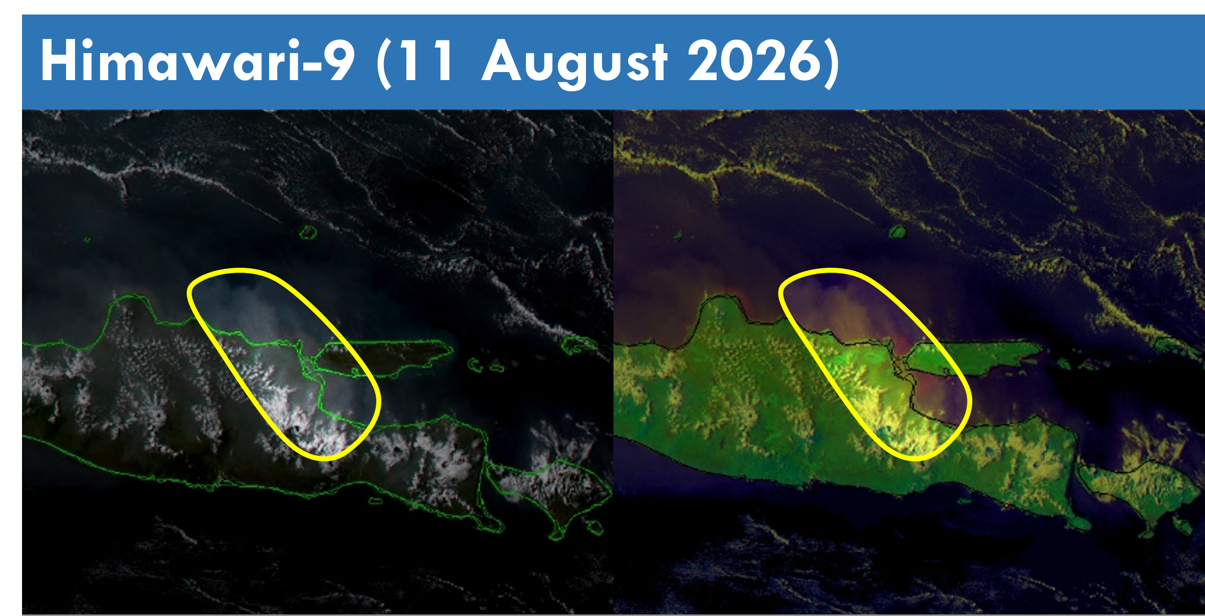
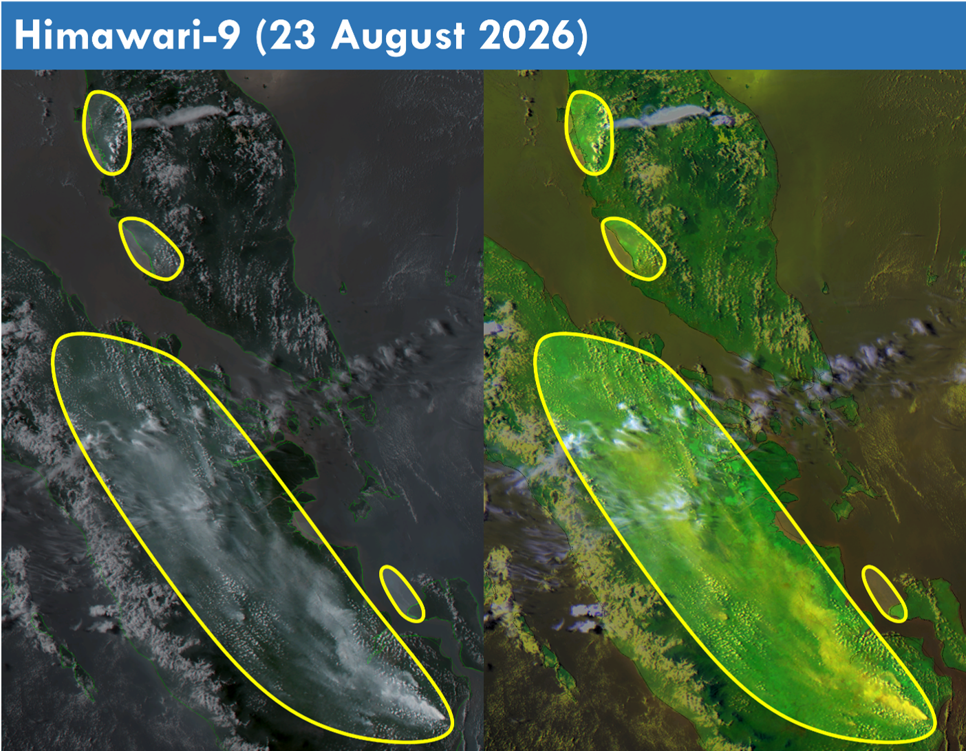
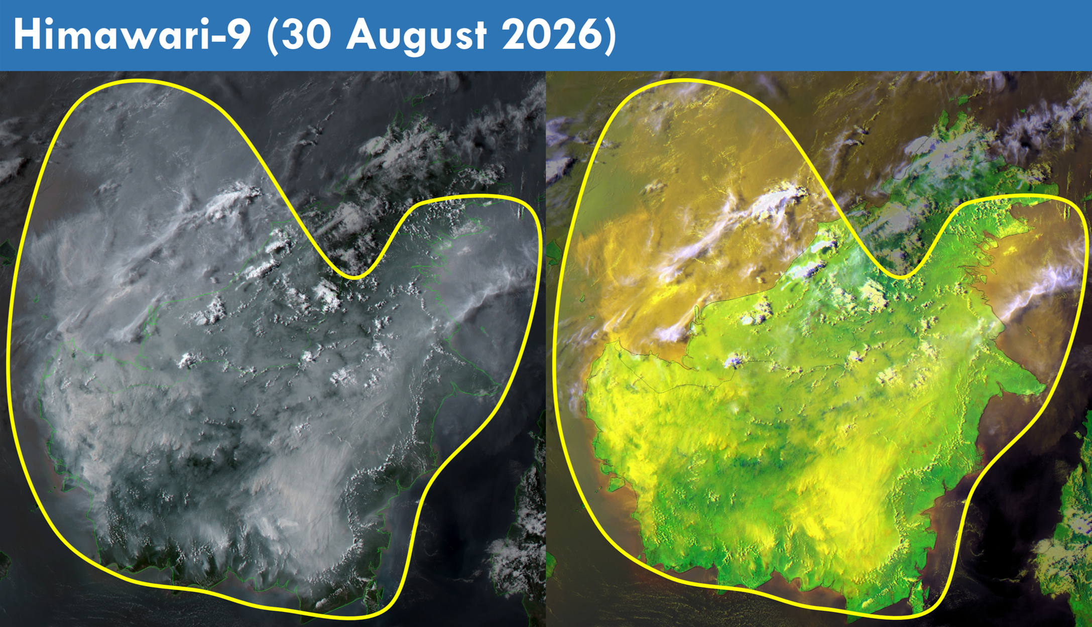
1.4 Scattered to widespread persistent and intense hotspots were detected in parts of Kalimantan and the southern parts of Sumatra (Figures 4 and 5). Towards the end of the review period, moderate to dense transboundary smoke plumes were observed to cover North, West and Central Kalimantan, Brunei, the western and central parts of Sarawak and the southern parts of Sabah (Figure 6 and 9). Moderate to dense smoke plumes were also observed to emanate from hotspots detected in other parts of Kalimantan, the central and southern parts of Sumatra, the western parts of Peninsular Malaysia and the eastern parts of Java (Figures 6, 7, 8 and 9).

1.5 Over the northern ASEAN region, the overall hotspot and smoke haze situation remained subdued (Figures 4 and 5).
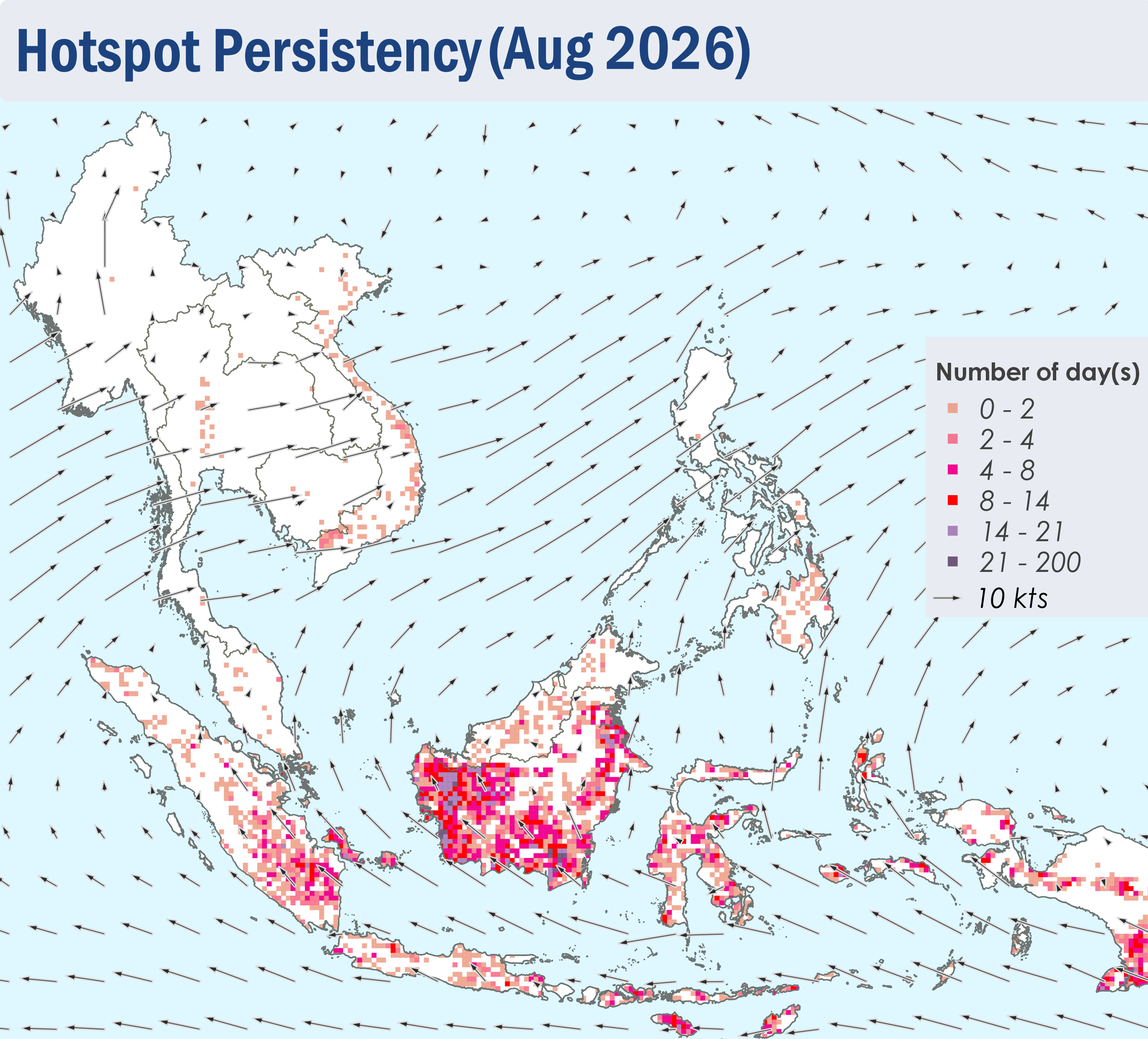
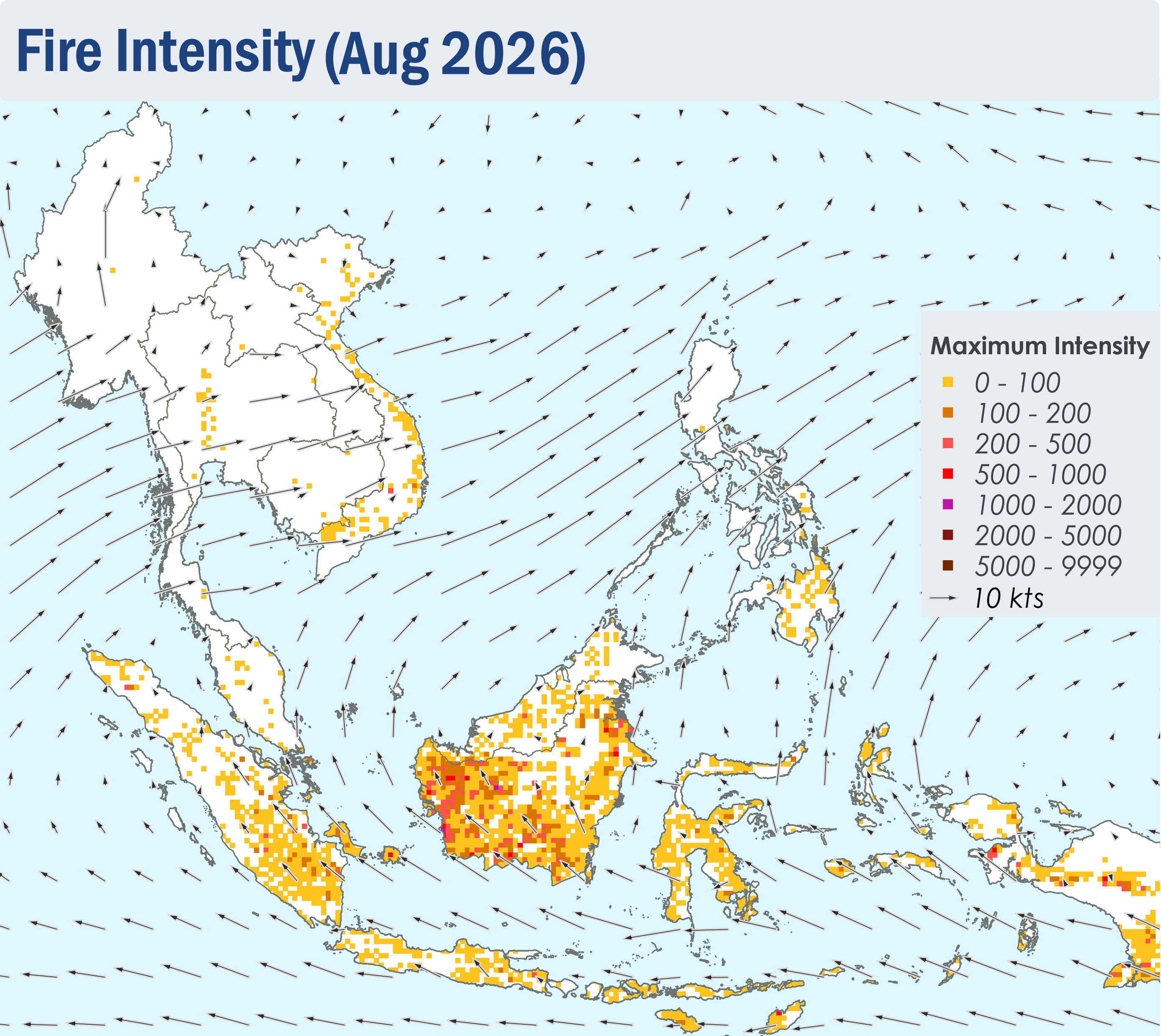
 

Figure 4: Distribution of hotspots detected in August 2026 based on NOAA-20 satellite surveillance.


Figure 5: Maximum fire intensity in August 2026 based on NOAA-20 satellite surveillance.


Figure 6: Number of days with moderate to dense smoke haze observed in August 2026 based on satellite imagery, ground observations, and air quality reports.


Figure 7: Moderate smoke plumes observed over the eastern parts of Java on 11 August 2026. (Source: Himawari-9 satellite surveillance)


Figure 8: Moderate to dense smoke plumes observed over the central and southern parts of Sumatra and the western parts of Peninsular Malaysia on 23 August 2026. (Source: Himawari-9 satellite surveillance)


Figure 9: Moderate to dense transboundary smoke plumes observed to cover North, West and Central Kalimantan, Brunei, the western and central parts of Sarawak and the southern parts of Sabah on 30 August 2026. Moderate to dense smoke plumes were also observed in other parts of Kalimantan. (Source: Himawari-9 satellite surveillance)


August 5, 2026

Review of Regional Haze Situation for July 2026

Review of Regional Haze Situation for July 2026

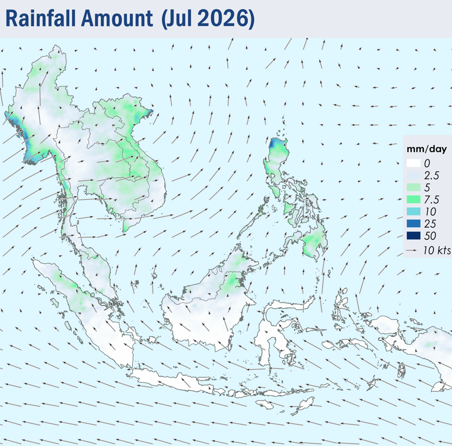
1.1 Southwest Monsoon conditions continued over the ASEAN region throughout July 2026. The prevailing winds across the southern ASEAN region blew mainly from the southeast to south, while winds over the northern ASEAN region blew mostly from the southwest to west (Figure 1).

1.2 Showers were observed over many parts of the ASEAN region during the review period, except over Java and the Lesser Sunda Islands, where persistent dry conditions were observed (Figure 1). The southern parts of Sumatra, and the southern and central parts of Borneo also experienced periods of dry weather. On 10 July 2026, the Alert Level 1 for the southern ASEAN region was activated, signalling the start of the dry season. Over the northern ASEAN region, relatively higher rainfall was recorded over the northern parts of Viet Nam and the Philippines due to Typhoon Maysak, Bavi and Noul.

Figure 1: Average Daily Rainfall and Mean Winds for July 2026. (Source: JAXA GsMaP and GFS, respectively)


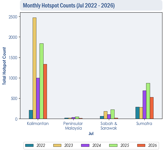
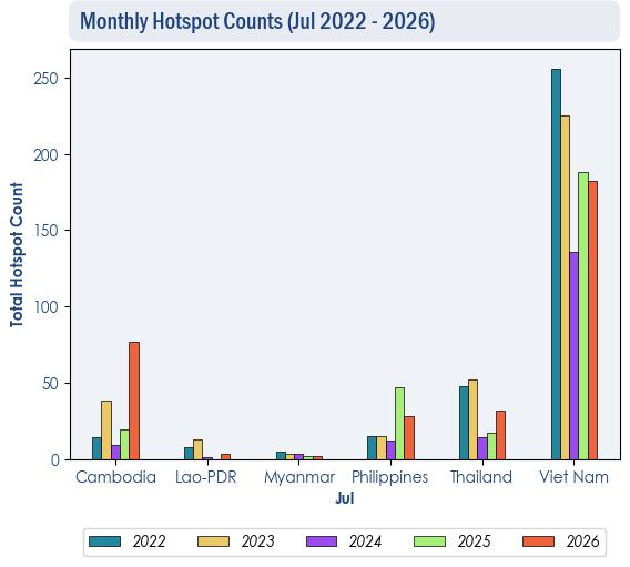
1.3 The hotspot counts for July 2026 over the ASEAN region were generally comparable to previous years (Figure 2 and 3), except in Cambodia, where hotspot counts were slightly higher relative to the past four years (Figure 3).

Figure 2: Hotspot counts for the southern ASEAN region for July (2022-2026) based on NOAA-20 satellite surveillance.


Figure 3: Hotspot counts for the northern ASEAN region for July (2022-2026) based on NOAA-20 satellite surveillance.


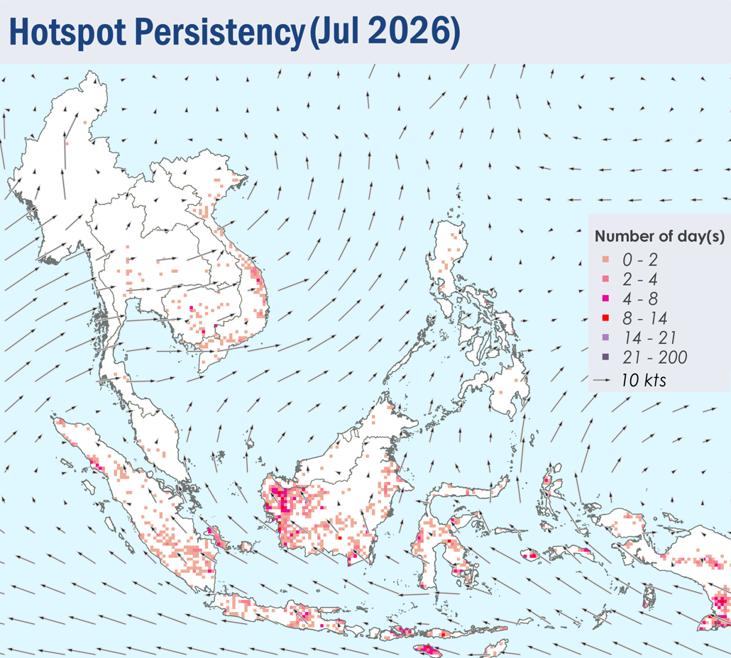
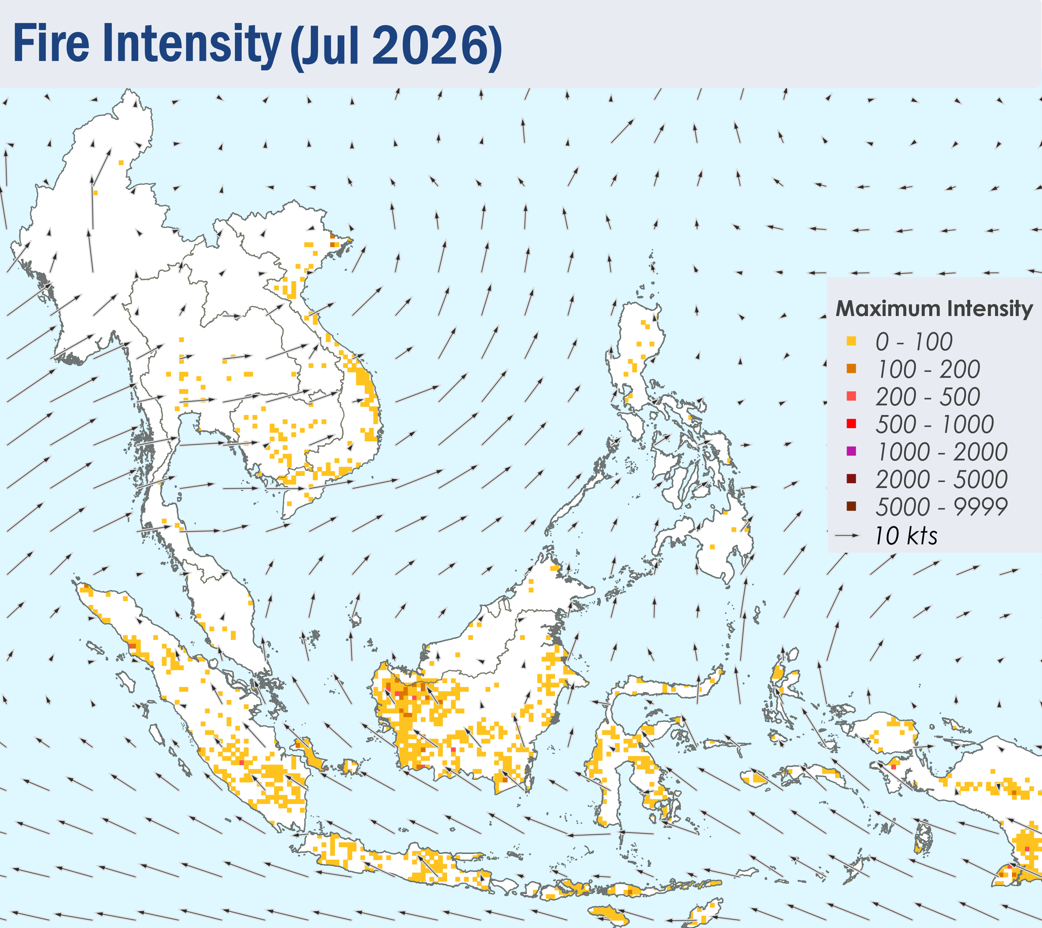
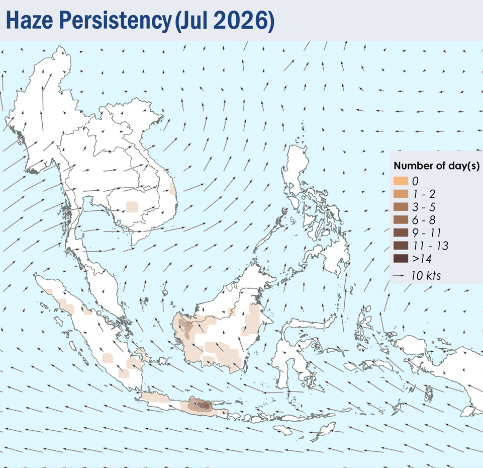
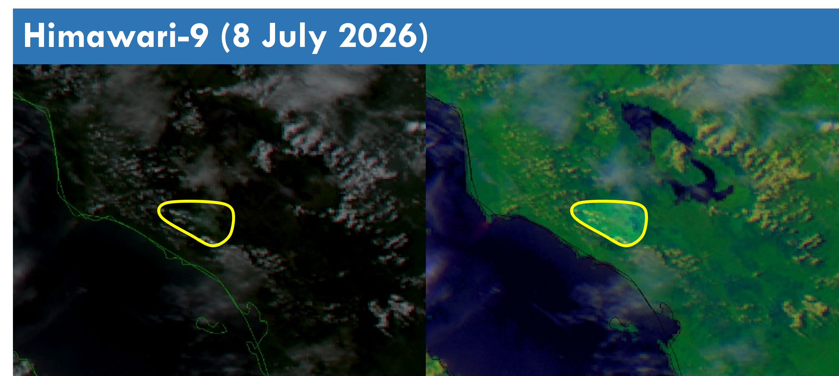
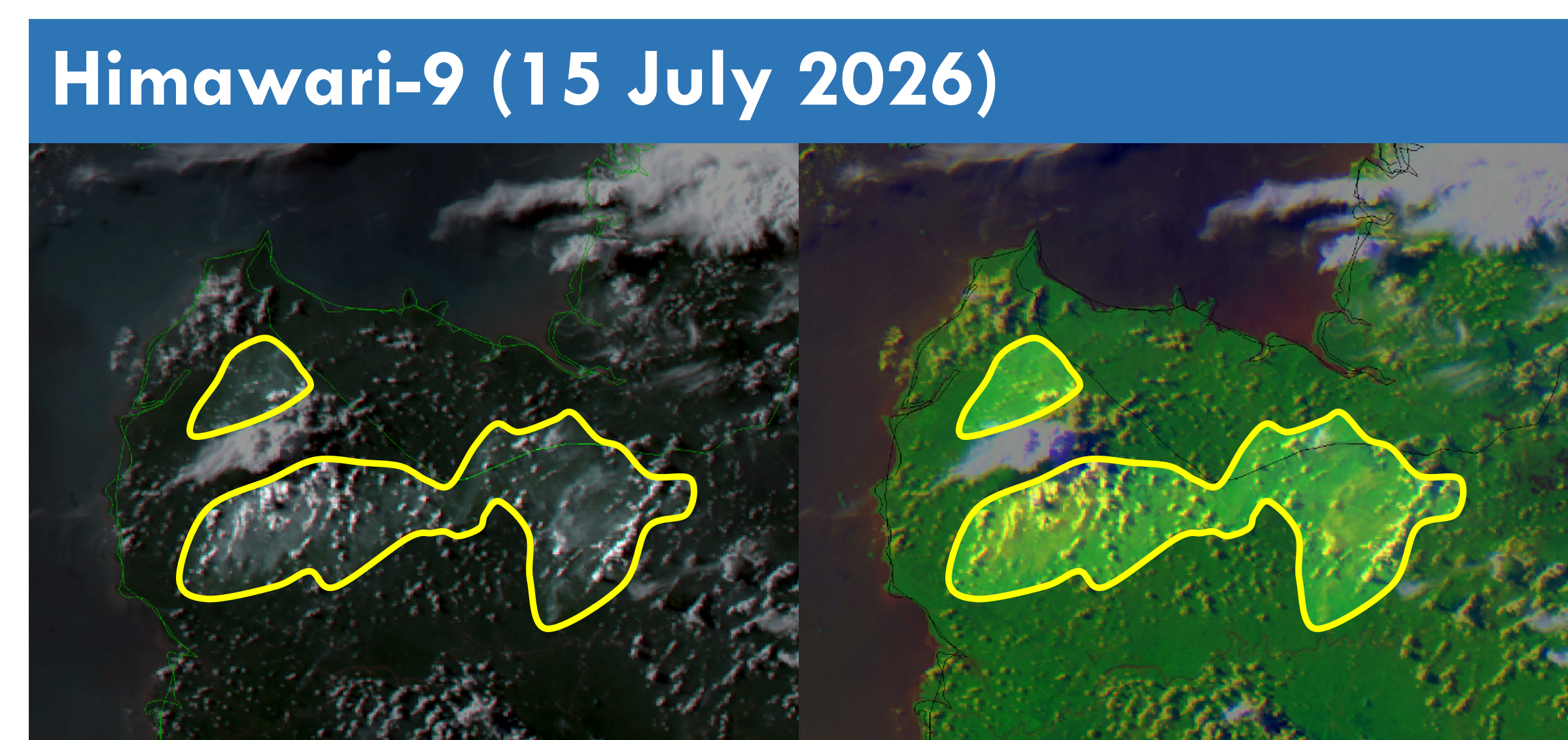
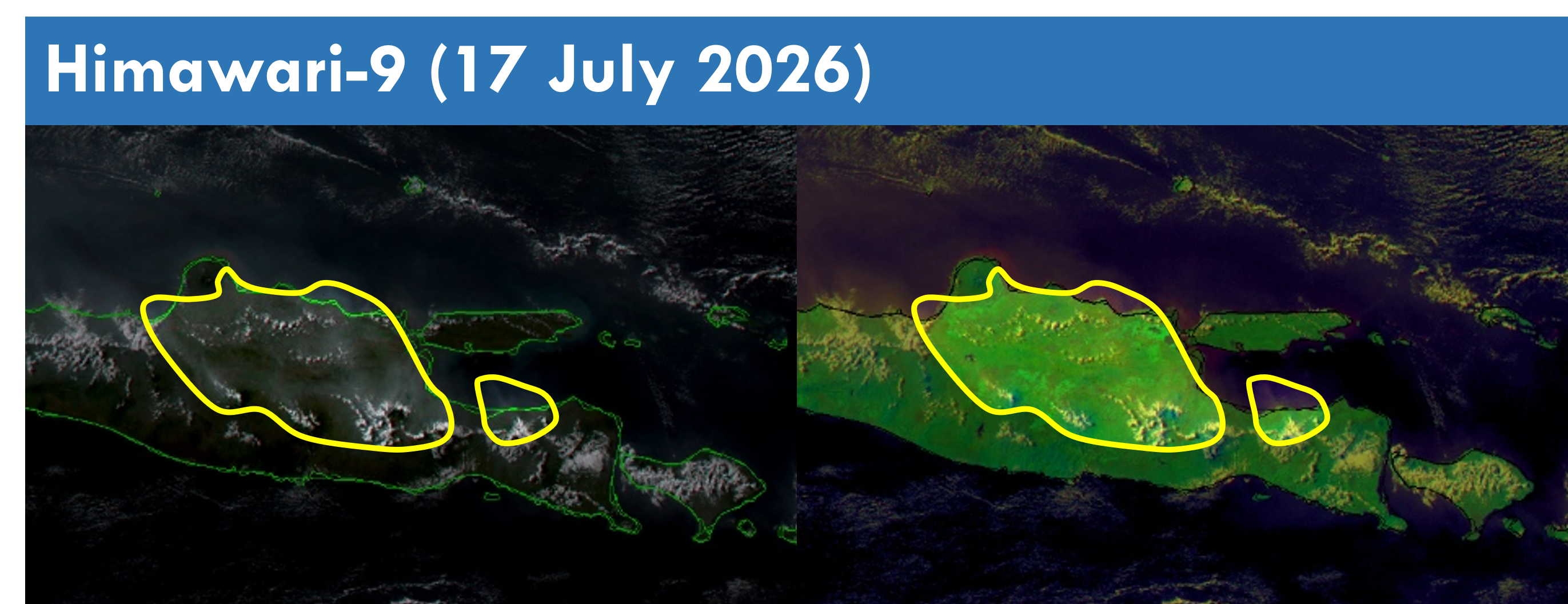
1.4 Hotspot activities were more persistent in West Kalimantan and parts of the Lesser Sunda Islands towards the latter half of the review period (Figure 4), with more intense fires detected in West Kalimantan as well (Figure 5). Slight to moderate smoke plumes were observed mainly over Java, parts of Borneo, and the northern and southern parts of Sumatra, with transboundary smoke haze observed to drift from West Kalimantan into the western parts of Sarawak on a few days (Figures 6 – 10). Slight to moderate smoke plumes were also observed over the central parts of Cambodia and Viet Nam on a few days.


Figure 4: Distribution of hotspots detected in July 2026 based on NOAA-20 satellite surveillance.


Figure 5: Maximum fire intensity in July 2026 based on NOAA-20 satellite surveillance.


Figure 6: Number of days with moderate to dense smoke haze observed in July 2026 based on satellite imagery, ground observations, and air quality reports.


Figure 7: Moderate localised smoke plume observed over the northern parts of Sumatra on 8 July 2026. (Source: Himawari-9 satellite surveillance)


Figure 8: Moderate smoke plumes observed over West Kalimantan drifting in the northwest direction into the western part of Sarawak on 15 July 2026. (Source: Himawari-9 satellite surveillance)


Figure 9: Slight to moderate localised smoke plumes observed over the eastern parts of Java on 17 July 2026. (Source: Himawari-9 satellite surveillance)


Figure 10: Moderate localised smoke plumes observed over Central and South Kalimantan on 26 July 2026. (Source: Himawari-9 satellite surveillance)

July 13, 2026

Review of Regional Haze Situation for June 2026

Review of Regional Haze Situation for June 2026

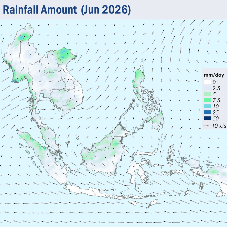
1.1 Southwest Monsoon conditions became fully established in early June 2026. The prevailing winds across the southern ASEAN region blew mainly from the southeast to south, while the prevailing winds over the northern ASEAN region blew mostly from the south to west (Figure 1).

1.2 Rainfall prevailed over most parts of the ASEAN region during the review period, except over the southern parts of Sumatra and Borneo, as well as Java and the Lesser Sunda Islands where drier conditions were observed (Figure 1).

Figure 1: Average Daily Rainfall and Mean Winds for June 2026. (Source: JAXA GsMaP and GFS, respectively)


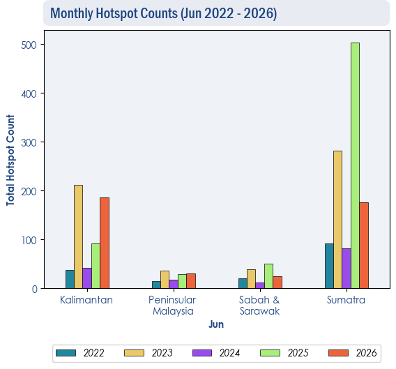
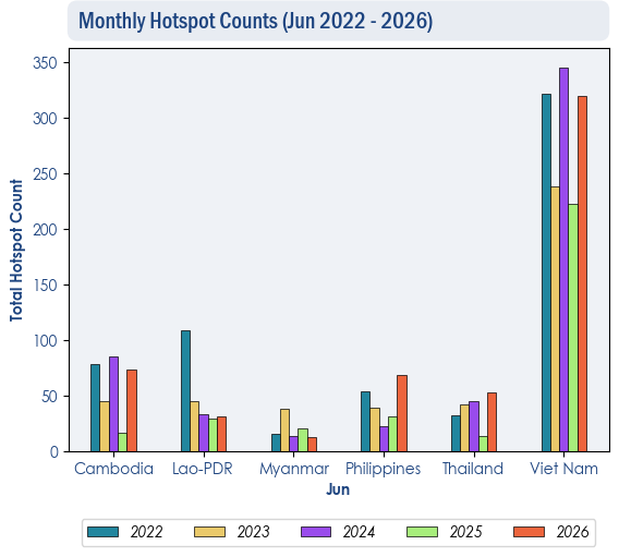
1.3 Over the southern ASEAN region, the hotspot counts for June 2026 were generally lower than or comparable to previous years (Figure 2). Over the northern ASEAN region, the hotspot counts for June 2026 were generally comparable to previous years, except in Thailand and the Philippines, where hotspot counts were slightly higher compared to the past 5 years (Figure 3).

Figure 2: Hotspot counts for the southern ASEAN region for June (2022-2026) based on NOAA-20 satellite surveillance.


Figure 3: Hotspot counts for the southern ASEAN region for June (2022-2026) based on NOAA-20 satellite surveillance.


1.4 During the review period, few to isolated hotspots were detected in the ASEAN region, with more persistent and intense fires in the southern parts of Sumatra, West Kalimantan, Java and the Lesser Sunda Islands, as well as parts of Viet Nam (Figure 4). During periods of dry weather over the southern ASEAN region, slight to moderate smoke plumes were observed emitting from hotspots detected mainly in the northern and central parts of Sumatra, Java and parts of Borneo (Figures 6, 7, 8 and 9).


Figure 4: Distribution of hotspots detected in June 2026 based on NOAA-20 satellite surveillance.


Figure 5: Maximum fire intensity in June 2026 based on NOAA-20 satellite surveillance.


Figure 6: Number of days with moderate to dense smoke haze observed in June 2026 based on satellite imagery, ground observations, and air quality reports.


Figure 7: Moderate localised smoke plume observed over the northern parts of Sumatra on 3 June 2026. (Source: NOAA-20 satellite surveillance)


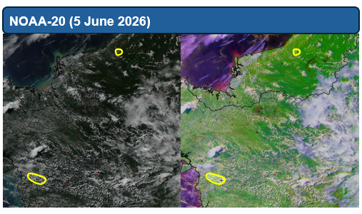
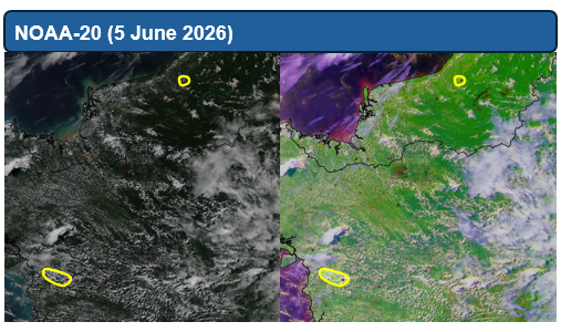
Figure 8: Moderate localised smoke plumes were observed over West Kalimantan and the central parts of Sarawak on 5 June 2026. (Source: Himawari-9 satellite surveillance)


Figure 9: Moderate localised smoke plume observed over the eastern parts of Java on 29 June 2026. (Source: Himawari-9 satellite surveillance)

June 8, 2026

Review of Regional Haze Situation for May 2026

Review of Regional Haze Situation for May 2026

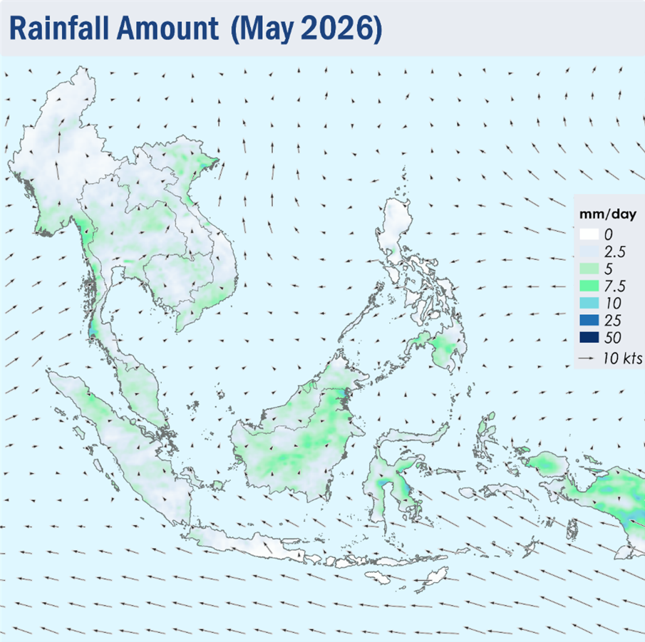
1.1 Light and variable winds were observed over many parts of the ASEAN region during the review period of May 2026 (Figure 1). Over the Mekong sub-region, the prevailing winds were mostly light and southerly, while southeasterly winds continued to dominate over Java, Sulawesi and the Lesser Sunda Islands.

1.2 Overall, the ASEAN region experienced wet weather during the review period as the monsoon rainband shifted northwards and was situated over the area near the Equator. The Alert Level for the Mekong sub-region was downgraded to Level 0 on 14 May 2026 following the increase in showers and the expected persistent rainfall over the sub-region. The southern ASEAN region continued to experience wet weather, except for drier conditions over Java and the Lesser Sunda Islands.

Figure 1: Average Daily Rainfall and Mean Winds for May 2026. (Source: JAXA GsMaP and GFS, respectively)

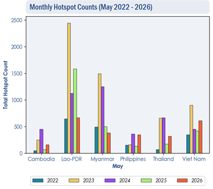
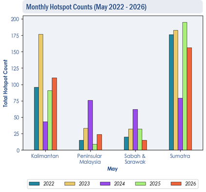
1.3 Hotspot counts in the ASEAN region were generally comparable to the previous years.

Figure 2: Hotspot counts for the northern ASEAN region for May (2022-2026) based on NOAA-20 satellite surveillance.

Figure 3: Hotspot counts for the southern ASEAN region for May (2022-2026) based on NOAA-20 satellite surveillance.

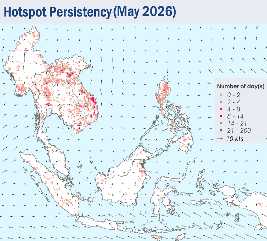
1.4 Isolated hotspots were detected in the northern ASEAN region, particularly in the northern parts of Lao PDR and the central parts of Viet Nam where hotspots are more intense and persistent.

1.5 For the southern ASEAN region, a few to isolated hotspots were mostly detected in parts of Sumatra, Borneo and Peninsular Malaysia.

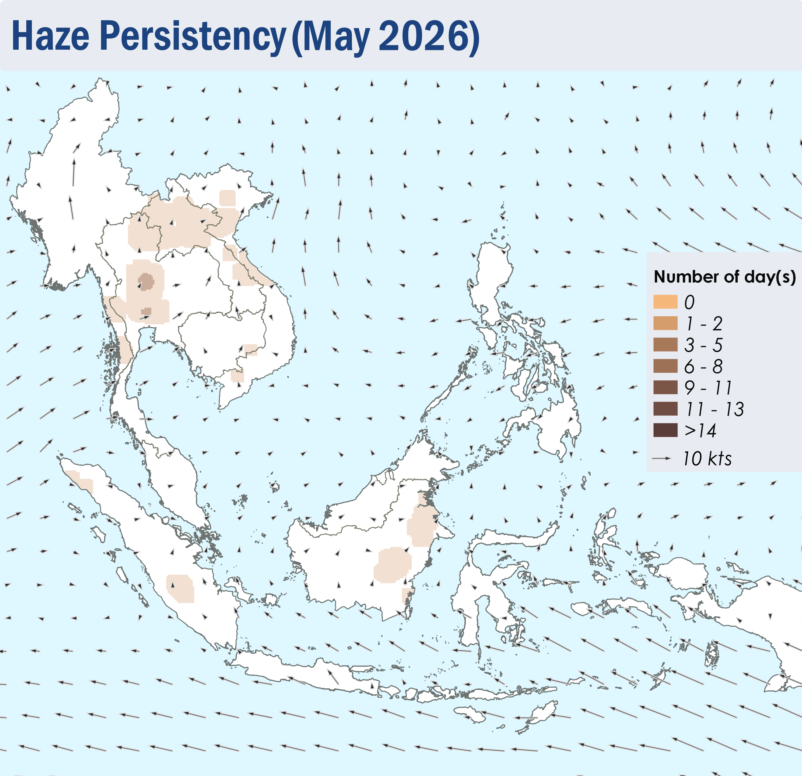
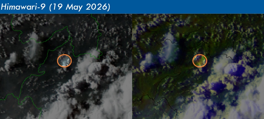
1.6 During the first half of May 2026, slight to moderate smoke haze was observed over the southern parts of Myanmar and the northern and central parts of Thailand. Localised smoke plumes were also occasionally observed over the parts of Kalimantan in mid-May, as well as parts of Sumatra and the northern parts of Lao PDR and Viet Nam in the later half of the review period.

Figure 4: Distribution of hotspots detected in May 2026 based on NOAA-20 satellite surveillance.

Figure 5: Maximum fire intensity in May 2026 based on NOAA-20 satellite surveillance.

Figure 6: Number of days with moderate to dense smoke haze observed in May 2026 based on satellite imagery, ground observations, and air quality reports.

Figure 7: Slight to moderate localised smoke plumes observed over northern Lao PDR on 19 May 2026. (Source: Himawari-9 satellite surveillance)

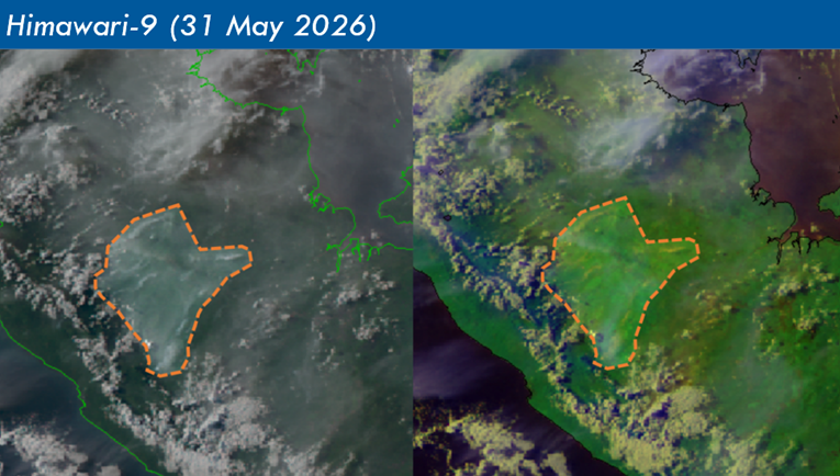
Figure 8: Slight and localised smoke plumes observed over the southern parts of Sumatra on 31 May 2026. (Source: Himawari-9 satellite surveillance)

May 11, 2026

Review of Regional Haze Situation for April 2026

Review of Regional Haze Situation for April 2026

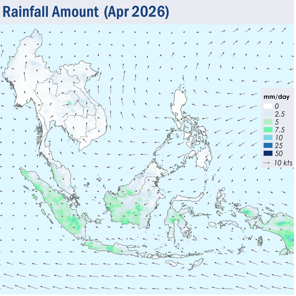
1.1 In April 2026, the prevailing winds across most of the ASEAN region turned light and variable in direction, except for the Philippines where the winds blew mostly from the northeast to east, and in the southern and central parts of the Mekong sub-region where winds blew from the southeast or southwest, as the monsoon rainband shifted northwards towards the Equator (Figure 1). This is characterised with the transition of the Northeast Monsoon into the inter-monsoon conditions.

1.2 Although isolated rainfall was observed over some parts of the Mekong sub-region and the southern parts of Philippines, dry conditions continued over most of the northern ASEAN region during the review period (Figure 1). There was a gradual increase in the shower activities in the second half of the month. In view of the expected ongoing rainfall over the Mekong sub-region, which could alleviate hotspot and haze conditions, the Alert Level for the sub-region was downgraded to Alert Level 2 on 24 April 2026. Meanwhile, showers prevailed over most of the southern ASEAN region, apart from the eastern parts of Peninsular Malaysia and the northern and eastern parts of Borneo, where conditions were drier (Figure 1).

Figure 1: Average Daily Rainfall and Mean Winds for April 2026. (Source: JAXA GsMaP and GFS, respectively)


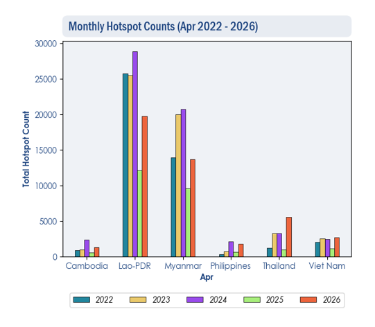
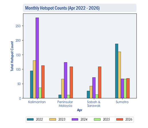
1.3 Over the northern ASEAN region, the hotspot counts for April 2026 were generally higher than or comparable to previous years, notably in Thailand where the hotspot counts were the highest in 5 years (Figure 2). Over the southern ASEAN region, the hotspot counts for April 2026 were generally lower or comparable to previous years, except in Sabah and Sarawak, where the highest hotspot count was recorded in 5 years (Figure 3).


Figure 2: Hotspot counts for the northern ASEAN region for April (2022-2026) based on NOAA-20 satellite surveillance.


Figure 3: Hotspot counts for the southern ASEAN region for April (2022-2026) based on NOAA-20 satellite surveillance.


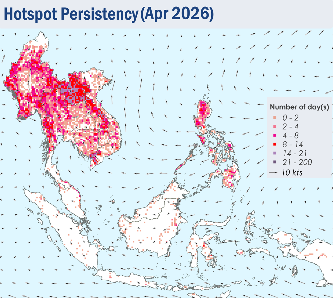
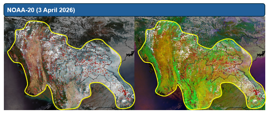
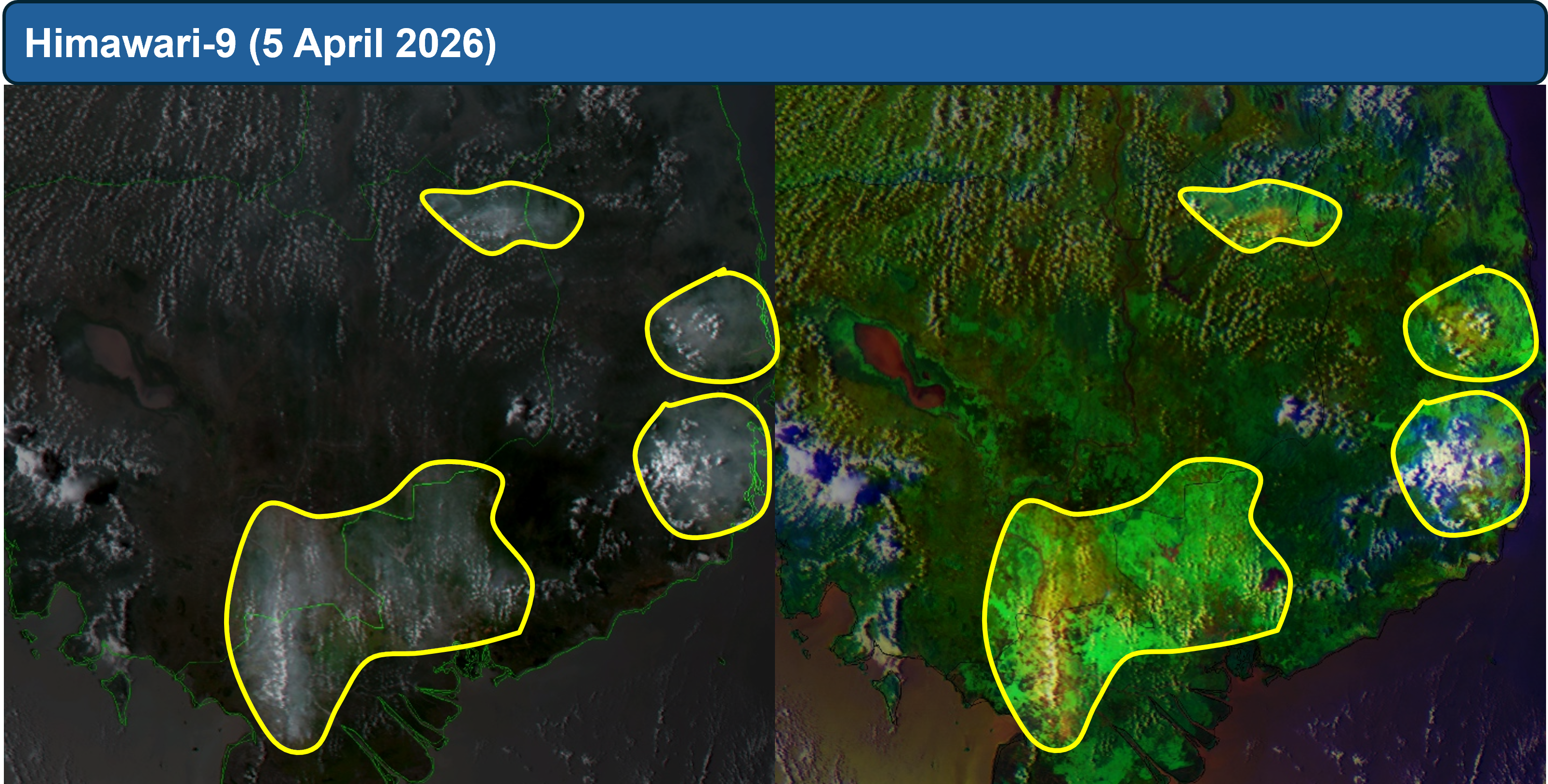
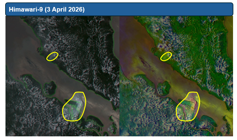
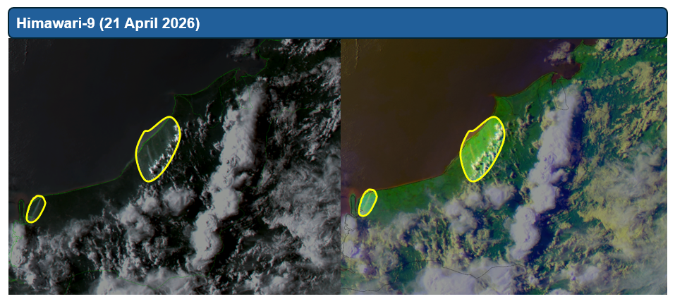
1.4 Scattered to widespread hotspots were detected in the Mekong sub-region. Persistent and intense hotspots were detected mostly in Myanmar, Lao PDR, as well as the northern and western parts of Thailand (Figures 4 and 5). Moderate to dense transboundary smoke plumes were observed across the Mekong sub-region on many days, particularly over Myanmar, Thailand, Lao PDR, the northern and southern parts of Viet Nam, as well as the northern and southern parts of Cambodia (Figure 6, 7 and 8). During periods of dry weather over the southern ASEAN region, slight to moderate smoke plumes were observed emitting from hotspots detected mainly in parts of Peninsular Malaysia, the northern and central parts of Sumatra, as well as parts of Borneo. Dense plumes were also observed in the central parts of Sumatra (Figures 6, 9 and 10).
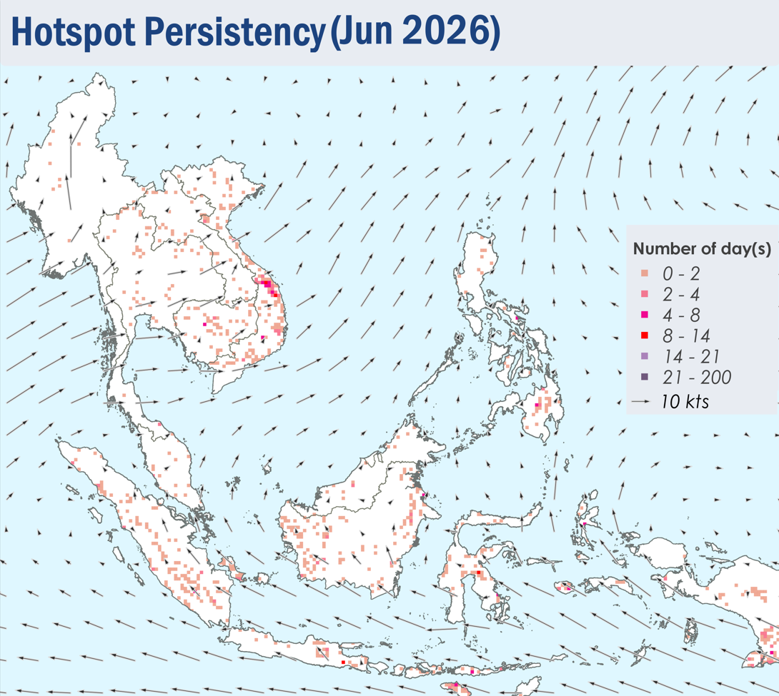
 

Figure 4: Distribution of hotspots detected in April 2026 based on NOAA-20 satellite surveillance.


Figure 5: Maximum fire intensity in April 2026 based on NOAA-20 satellite surveillance.


Figure 6: Number of days with moderate to dense smoke haze observed in April 2026 based on satellite imagery, ground observations, and air quality reports.


Figure 7: Moderate to dense transboundary smoke plumes observed over parts of Myanmar, Lao PDR, northern, central and eastern Thailand and the northern and central parts of Viet Nam on 3 April 2026. (Source: NOAA-20 satellite surveillance)


Figure 8: Moderate to dense localised and transboundary smoke plumes were observed over the northern and southern parts of Cambodia and the southern parts of Viet Nam on 5 April 2026. (Source: Himawari-9 satellite surveillance)


Figure 9: Moderate to dense localised smoke plume observed over the western parts of Peninsular Malaysia and the central parts of Sumatra on 3 April 2026. (Source: Himawari-9 satellite surveillance)


Figure 10: Slight to moderate smoke plumes observed over the northern coast of Sarawak on 21 April 2026. (Source: Himawari-9 satellite surveillance)


April 10, 2026

Review of Regional Haze Situation for March 2026

Review of Regional Haze Situation for March 2026

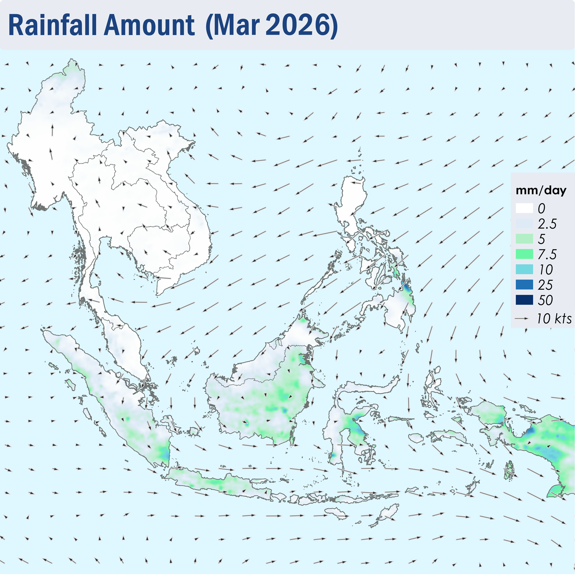
1.1 During March 2026, Northeast Monsoon conditions remained over the ASEAN region. Over regions north of the Equator, the prevailing low-level winds blew mainly from the northeast to east, except over the Mekong sub-region where the winds were generally weaker and blew mostly from the southeast or south (Figure 1). Over regions south of the Equator, the prevailing low-level winds blew from the west to north (Figure 1).

1.2 Dry conditions continued over most of the northern ASEAN region during the review period, except for some showers observed over the southern parts of the Philippines and the northern parts of Myanmar (Figure 1). Meanwhile, showers prevailed over most of the southern ASEAN region, apart from parts of Peninsular Malaysia, the central parts of Sumatra and the northern parts of Borneo, where conditions were drier (Figure 1).

Figure 1: Average Daily Rainfall and Mean Winds for March 2026. (Source: JAXA GsMaP and GFS, respectively)


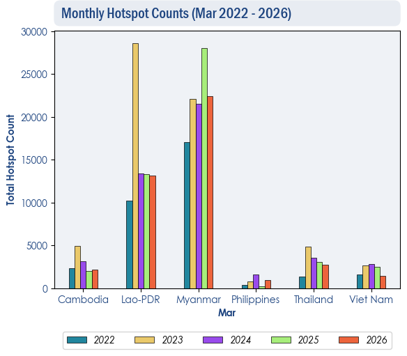
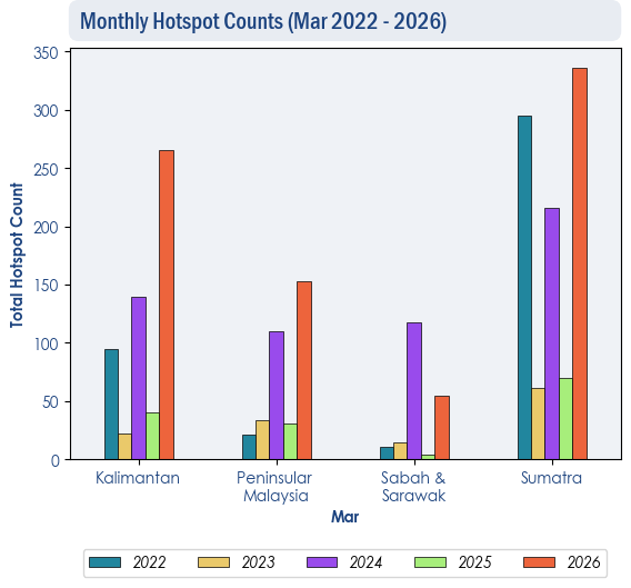
1.3 Over the northern ASEAN region, the hotspot counts for March 2026 were generally lower than or comparable to previous years (Figure 2). Over the southern ASEAN region, there was an increase in hotspot counts over Kalimantan, Peninsular Malaysia and Sumatra, with the highest count recorded in five years (Figure 3).


Figure 2: Hotspot counts for the northern ASEAN region for March (2022-2026) based on NOAA-20 satellite surveillance.


Figure 3: Hotspot counts for the southern ASEAN region for March (2022-2026) based on NOAA-20 satellite surveillance.


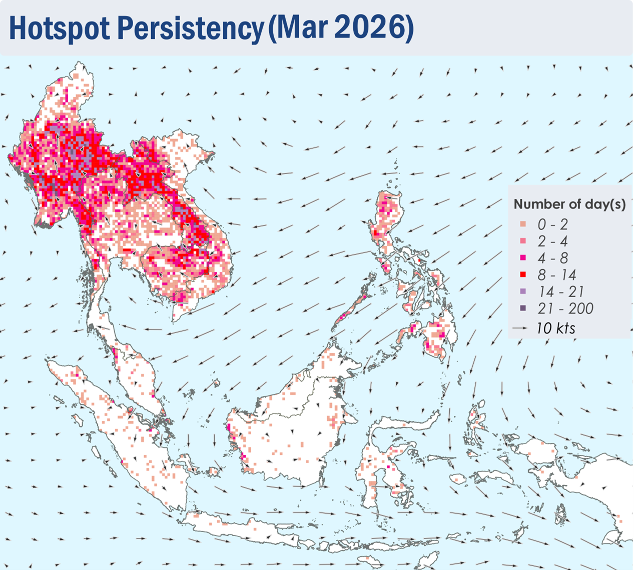
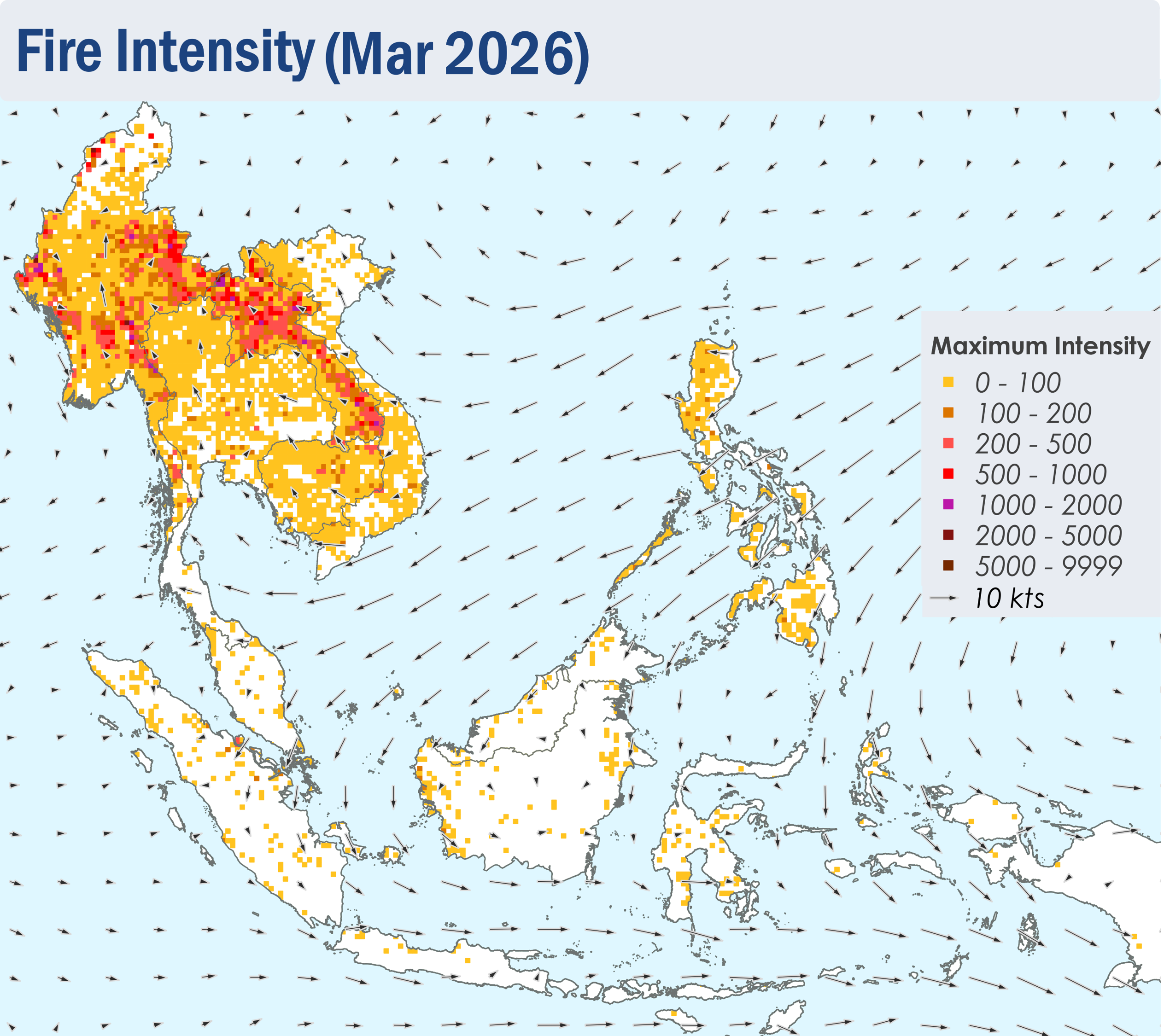
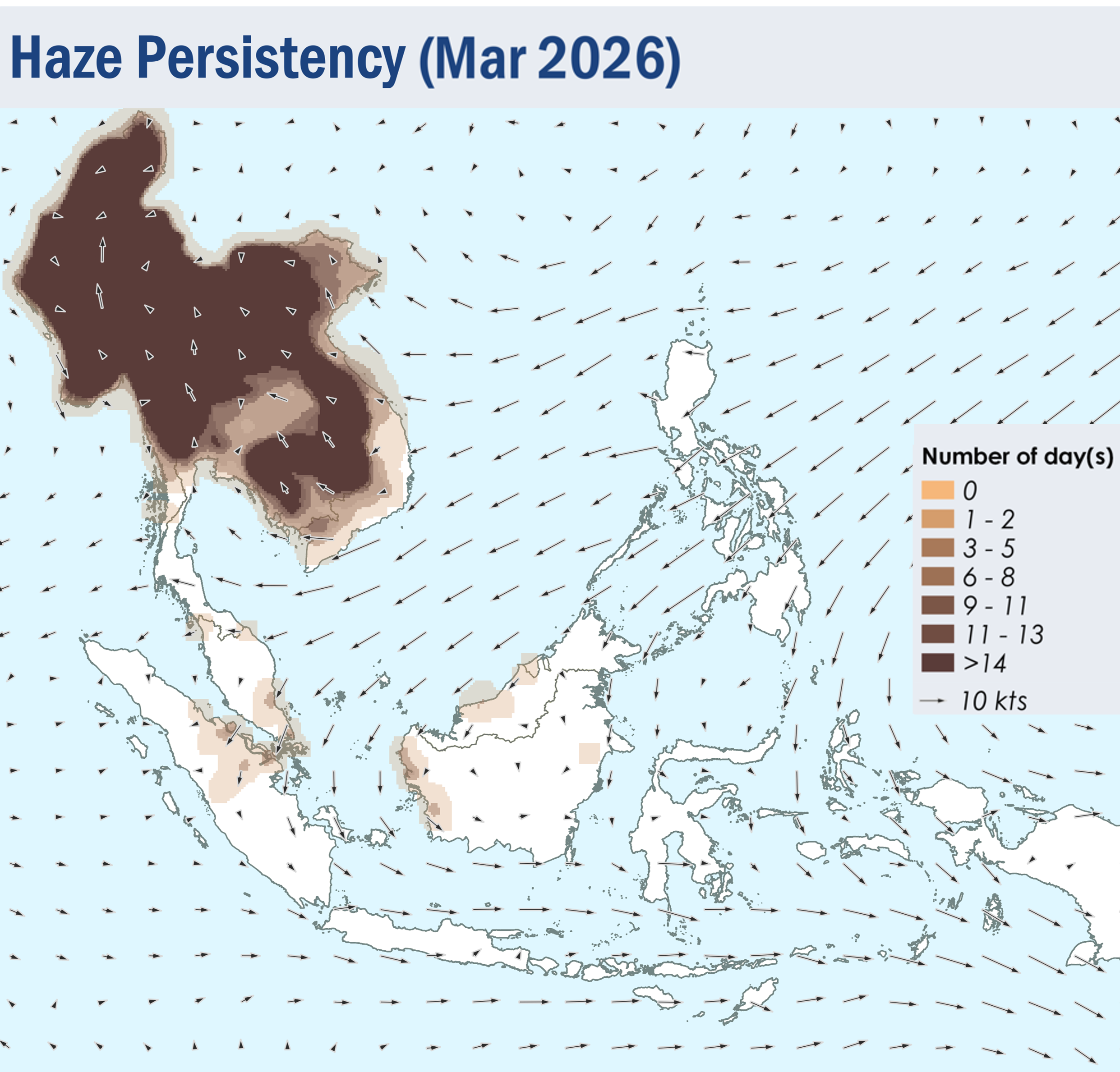
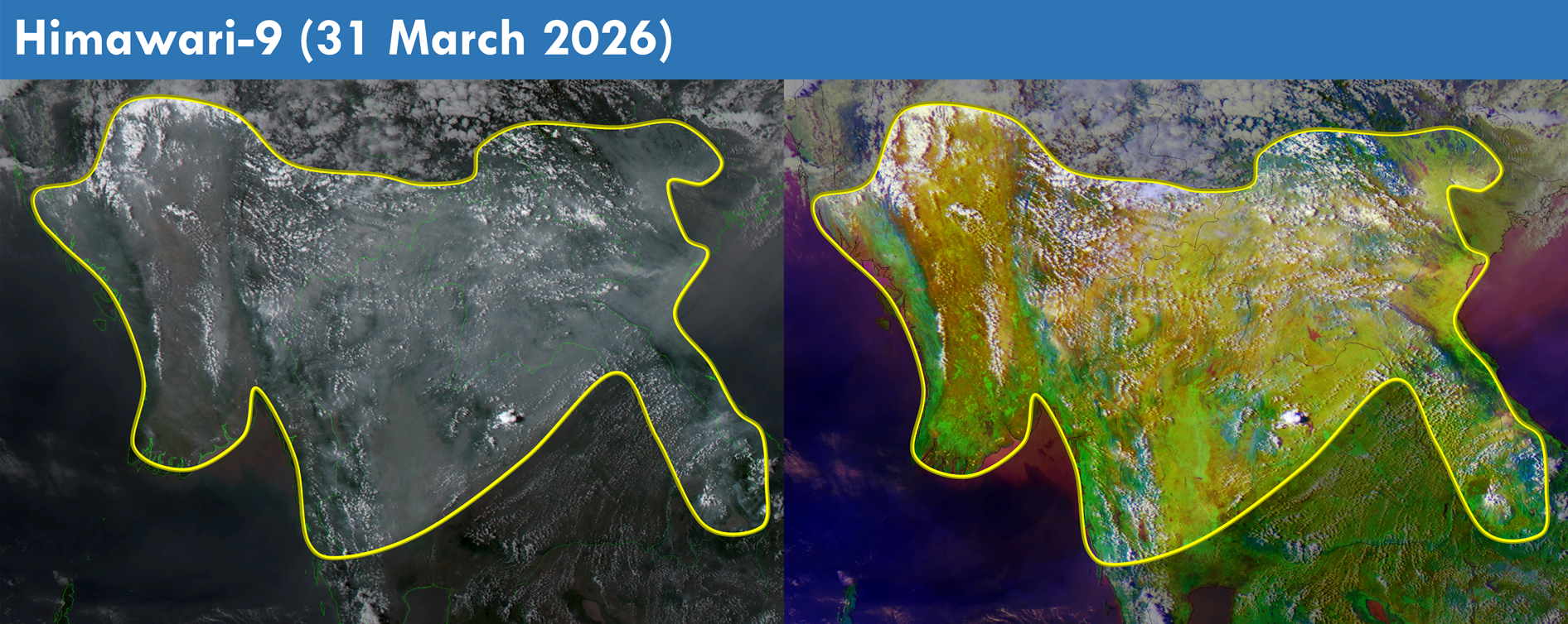
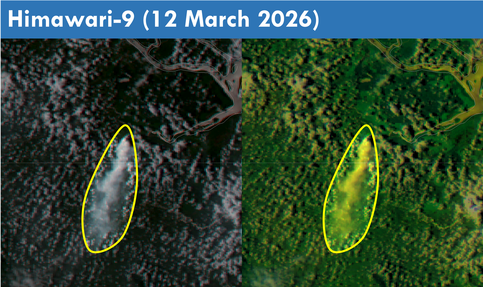
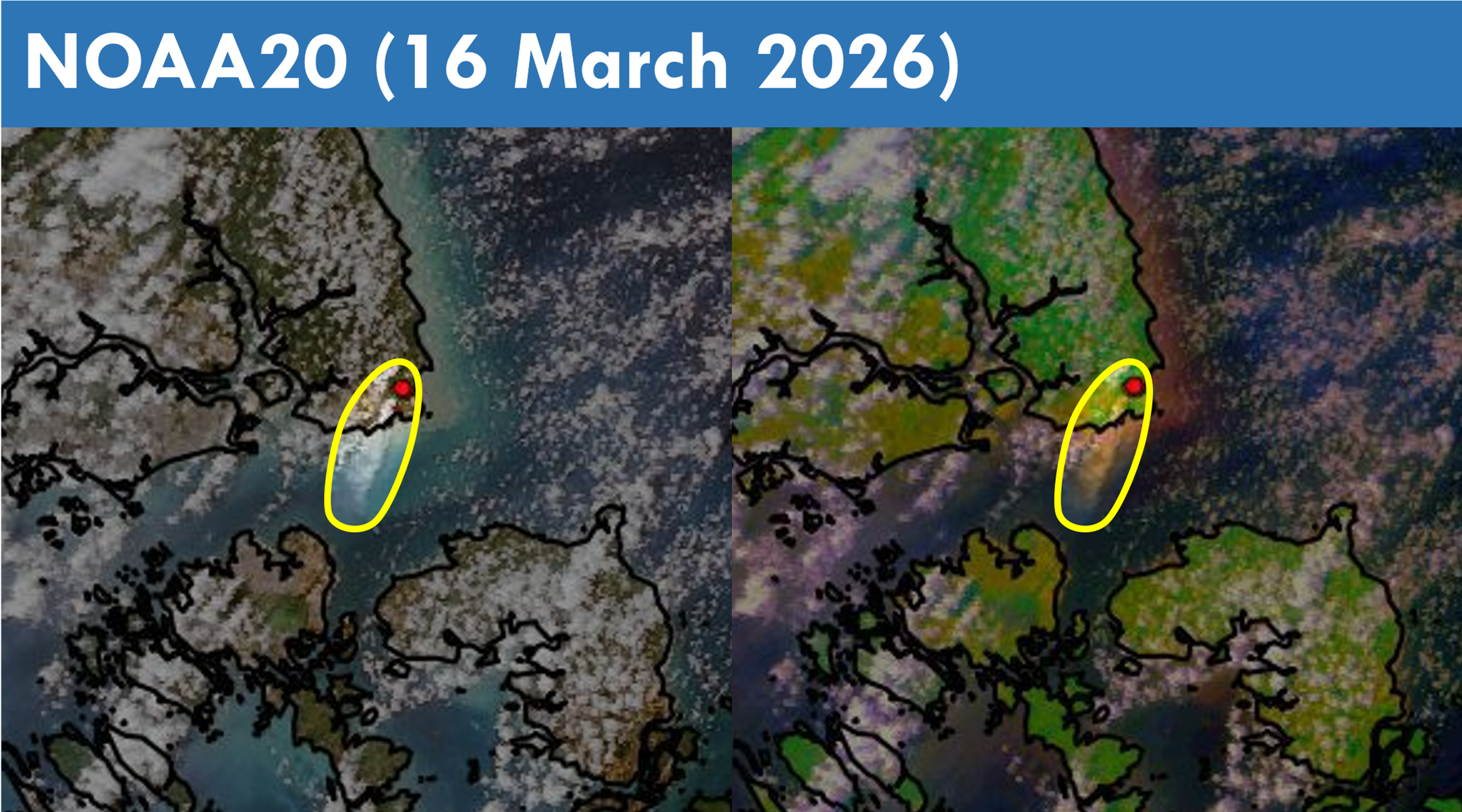
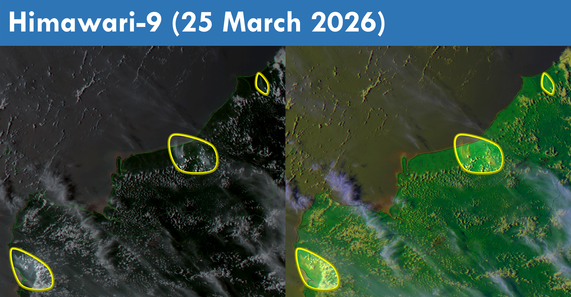
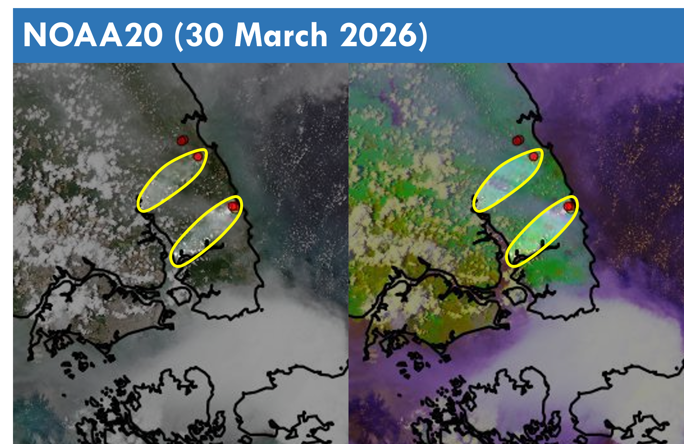
1.4 Scattered to widespread hotspots were detected in the Mekong sub-region. Persistent and intense hotspots were detected mostly in Myanmar, Lao PDR, as well as the northern parts of Thailand and Cambodia (Figures 4 and 5). Moderate to dense transboundary smoke plumes were observed across the Mekong sub-region on many days, particularly over the eastern parts of Myanmar and the northern parts of Thailand, Lao PDR and Viet Nam (Figure 6 and 7). During periods of dry weather over the southern ASEAN region, slight to moderate smoke plumes were observed emitting from hotspots detected mainly in parts of Peninsular Malaysia, the central parts of Sumatra and the northern and western parts of Borneo (Figures 6, 8, 9, 10 and 11).
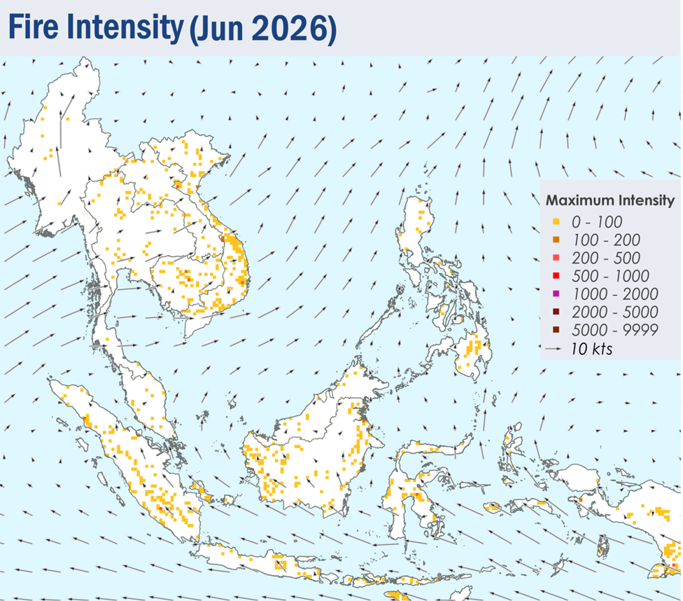
 

Figure 4: Distribution of hotspots detected in March 2026 based on NOAA-20 satellite surveillance.


Figure 5: Maximum fire intensity in March 2026 based on NOAA-20 satellite surveillance.


Figure 6: Number of days with moderate to dense smoke haze observed in March 2026 based on satellite imagery, ground observations, and air quality reports.


Figure 7: Moderate to dense transboundary smoke plumes observed over parts of Myanmar, northern, central and eastern Thailand, parts of Lao PDR and the northern and central parts of Viet Nam on 31 March 2026. (Source: Himawari-9 satellite surveillance)


Figure 8: Moderate localised smoke plume observed over the central parts of Sumatra on 12 March 2026. (Source: Himawari-9 satellite surveillance)


Figure 9: Moderate localised smoke plume observed over the southeastern parts of Peninsular Malaysia on 16 March 2026. (Source: NOAA20 satellite surveillance)


Figure 10: Slight to moderate smoke plumes observed over the northern parts of Borneo on 25 March 2026. (Source: Himawari-9 satellite surveillance)


Figure 11: Moderate smoke plumes observed over the southeastern parts of Peninsular Malaysia on 30 March 2026. (Source: NOAA20 satellite surveillance)


March 19, 2026

Review of Regional Haze Situation for February 2026

Review of Regional Haze Situation for February 2026

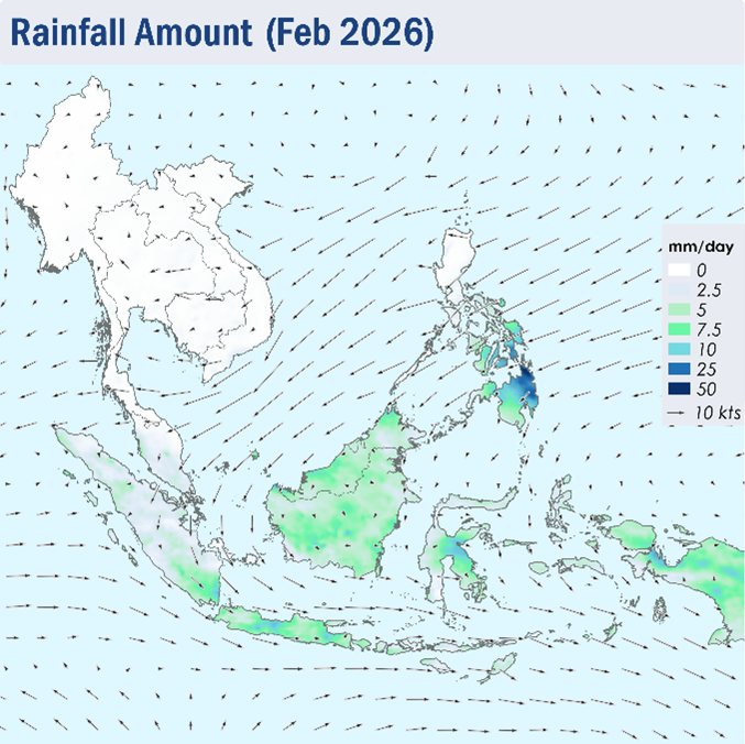
1.1 During February 2026, Northeast monsoon conditions were predominantly observed over the ASEAN region. While the prevailing winds blew mostly from the northeast or northwest over the region, the Mekong sub-region occasionally experienced days with prevailing light and variable winds. (Figure 1)

1.2 Extensive dry conditions were generally observed over the Mekong sub-region as well as the northern parts of the Philippines during the month of February 2026, though there were some showers observed over the southeastern and central parts of the Mekong sub-region on a few days during the last week of February. Parts of Peninsular Malaysia and Sumatra also experienced days with relatively lower rainfall during the month (Figure 1). Heavier showers were observed over the Philippines, which can be attributed to Tropical Storm Penha. To reflect the ongoing and expected dry weather conditions over the Mekong sub-region, ASMC issued Alert Level 2 for the Mekong sub-region on 2 February 2026.

Figure 1: Average Daily Rainfall and Mean Winds for February 2026. (Source: JAXA GsMaP and GFS, respectively)


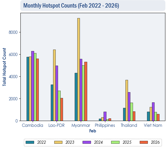
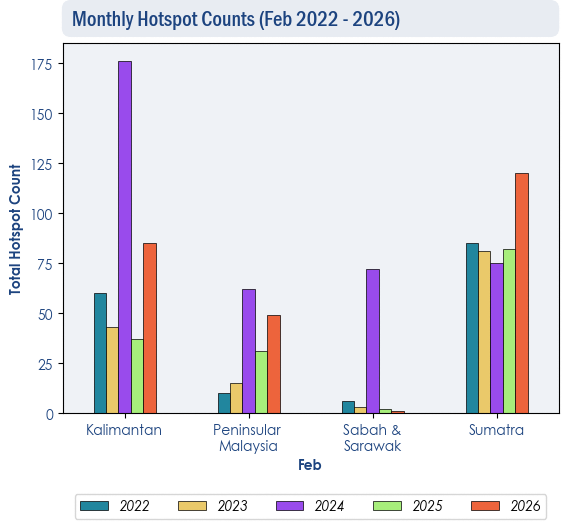
1.3 Despite the drier conditions, hotspot counts over the ASEAN region for February 2026 were observed to be much lower or comparable compared to the hotspot counts from the preceding years (2022-2025), except for Sumatra where hotspot counts were higher.


Figure 2: Hotspot counts for the northern ASEAN region for February (2022-2026) based on NOAA-20 satellite surveillance.


Figure 3: Hotspot counts for the southern ASEAN region for February (2022-2026) based on NOAA-20 satellite surveillance.


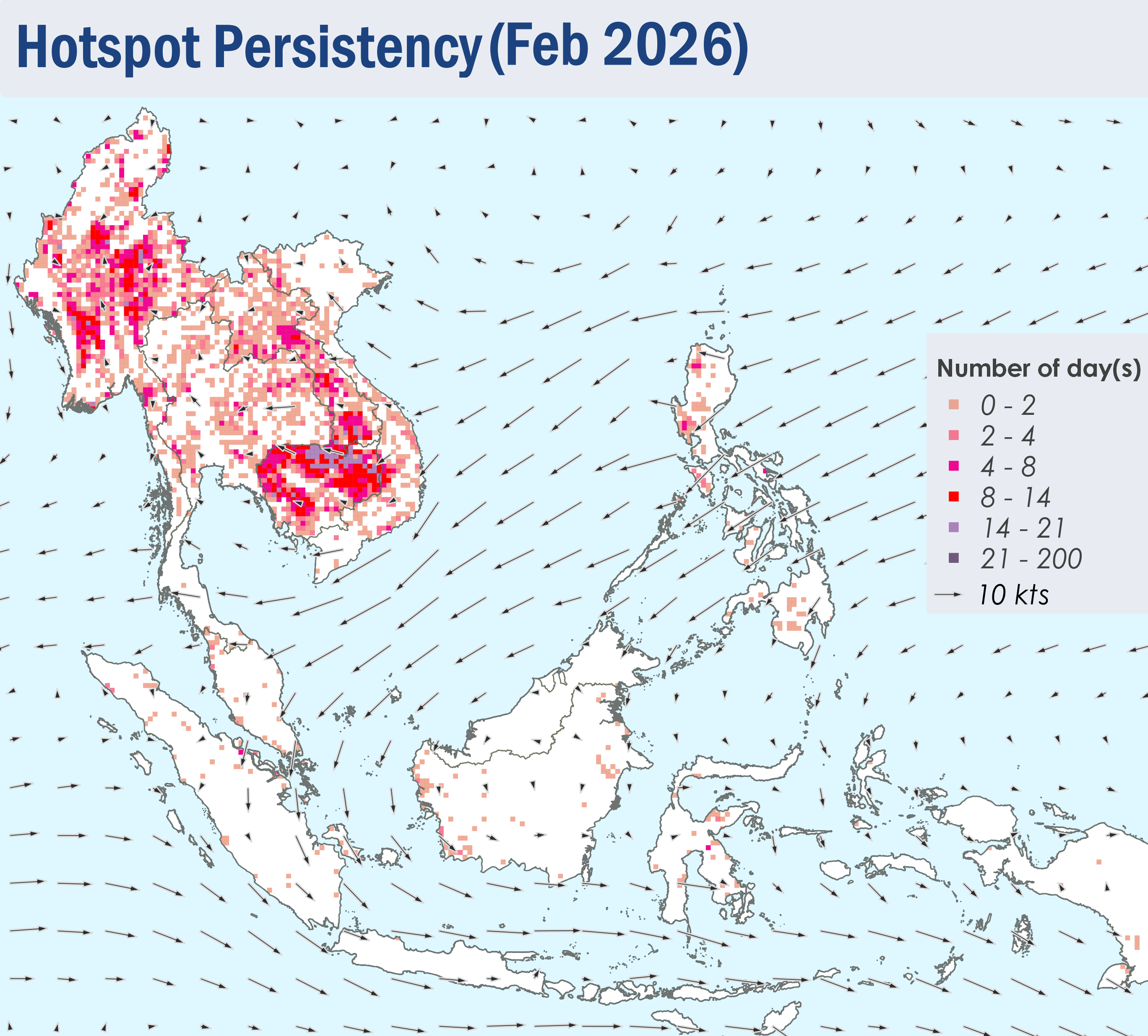
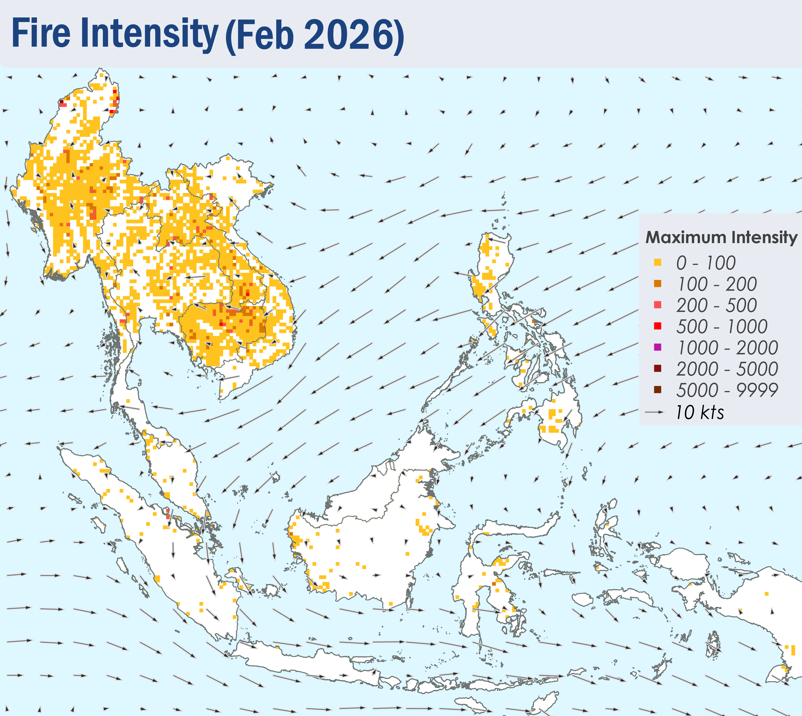
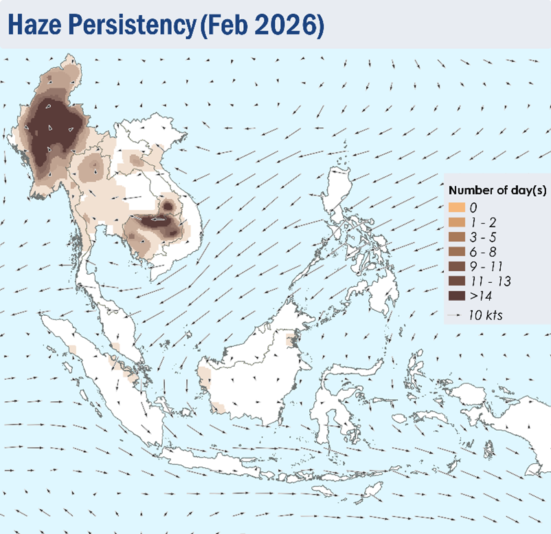
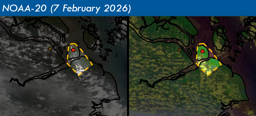
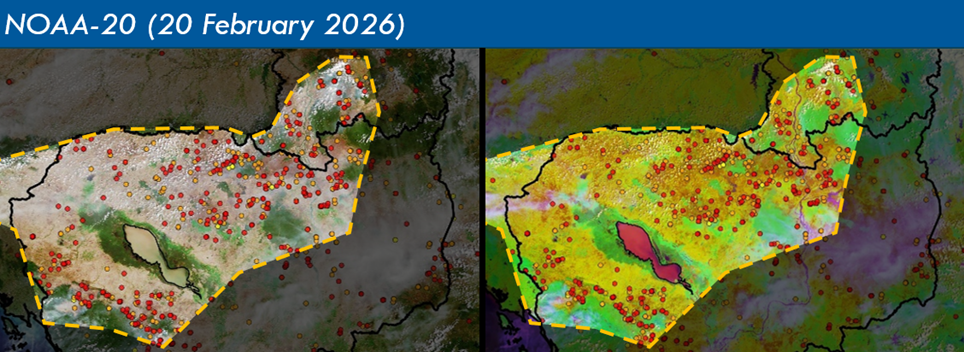
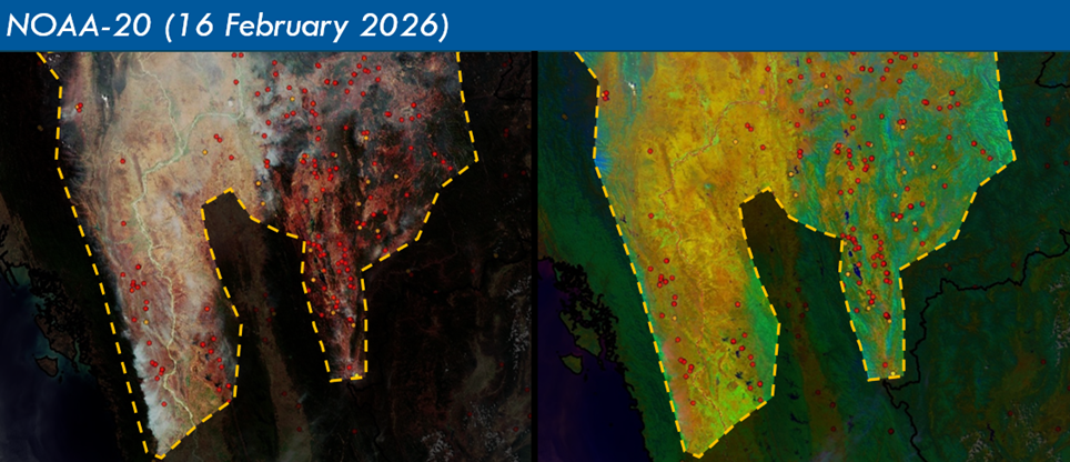
1.4 Scattered to widespread hotspots were often observed over the northern and western parts of Cambodia as well as the southern parts of Lao PDR (Figure 4), leading to moderate to dense smoke plumes observed over these areas for many days during February 2026 (Figure 6). Transboundary smoke haze would occasionally occur from the southern parts of Lao PDR to the northern parts of Cambodia, as well as from the western parts of Cambodia to the central parts of Thailand (Figure 8 & 9) . Moderate to dense smoke haze was observed to persist over the central and northern parts of Myanmar under the prevailing light winds situation (Figure 6 and 9 ). In the southern ASEAN region, Smoke plumes were also observed in the southern parts of Peninsular Malaysia, the central parts of Sumatra and in West Kalimantan for a few days in the month. (Figure 6 and 7 )


Figure 4: Distribution of hotspots detected in February 2026 based on NOAA-20 satellite surveillance.


Figure 5: Maximum fire intensity in February 2026 based on NOAA-20 satellite surveillance.


Figure 6: Number of days with moderate to dense smoke haze observed in February 2026 based on satellite imagery, ground observations, and air quality reports.


Figure 7: Moderate smoke plume observed over the central parts of Sumatra on 7 February 2026. (Source: NOAA-20 satellite surveillance)


Figure 8: Moderate to dense smoke plumes observed over Cambodia and Lao PDR on 20 February 2026, with transboundary haze drifting from Lao PDR to Cambodia. (Source: NOAA-20 satellite surveillance)


Figure 9: Moderate to dense smoke plumes over the central parts of Myanmar on 16 February 2026. (Source: NOAA-20 satellite surveillance)


February 16, 2026

Review of Regional Haze Situation for January 2026

Review of Regional Haze Situation for January 2026

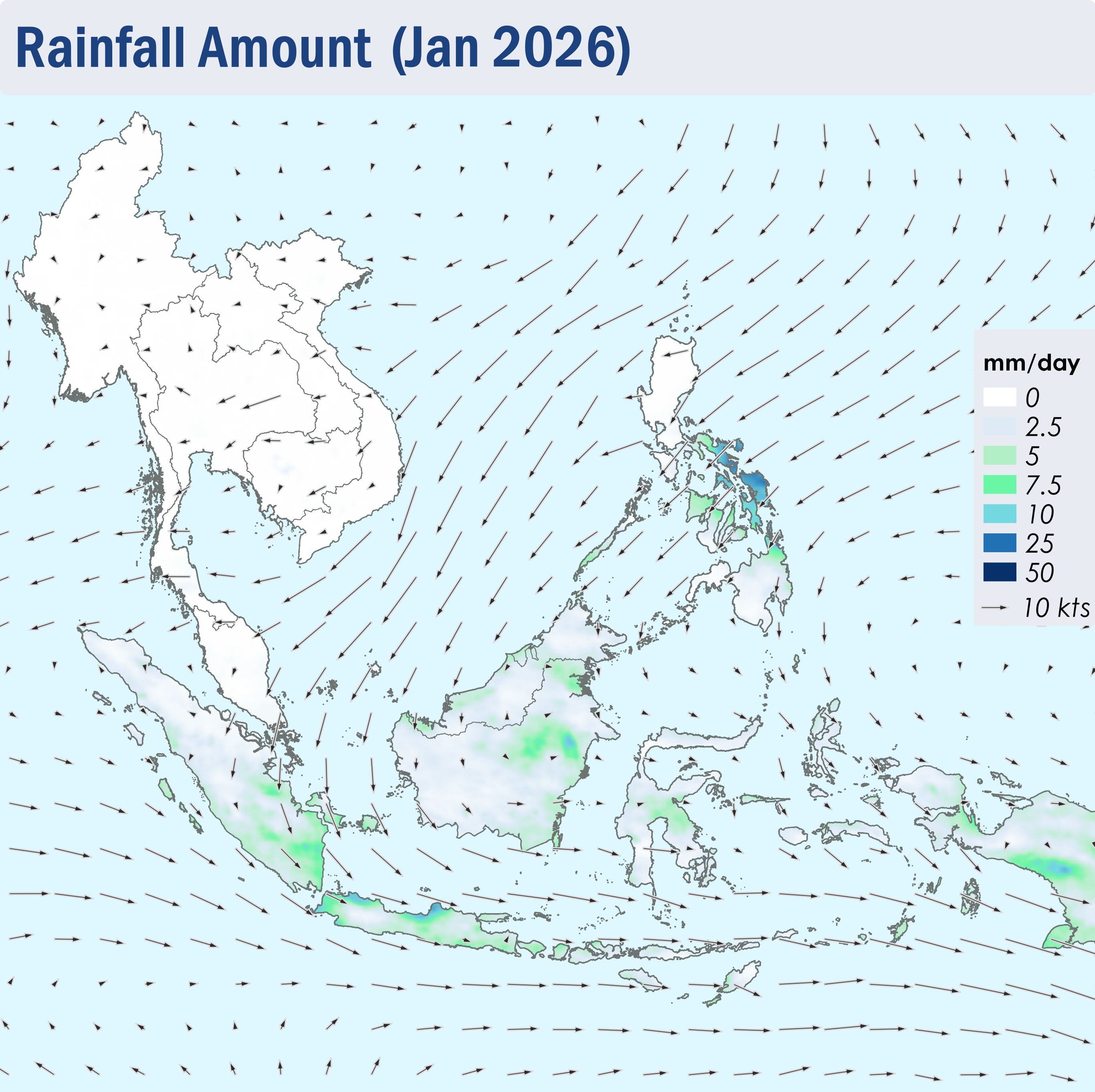
1.1 The Northeast Monsoon continued over the ASEAN region throughout January 2026. The prevailing low-level winds over regions north of the Equator blew mainly from the northeast to east, except over the northern parts of the Mekong sub-region where the winds were light and variable in direction (Figure 1). Over regions south of the Equator, the prevailing low-level winds blew mainly from the west to north (Figure 1).

1.2 Dry weather persisted over the Mekong sub-region, Peninsular Malaysia and the northern parts of the Philippines in January 2026. Showers were observed elsewhere in the ASEAN region (Figure 1), with the areas south of the Equator, the eastern parts of Borneo and the central parts of the Philippines experiencing higher rainfall. The latter was due to the influence of Tropical Storm NOKAEN.

Figure 1: Average Daily Rainfall and Mean Winds for January 2026. (Source: JAXA GsMaP and GFS, respectively)


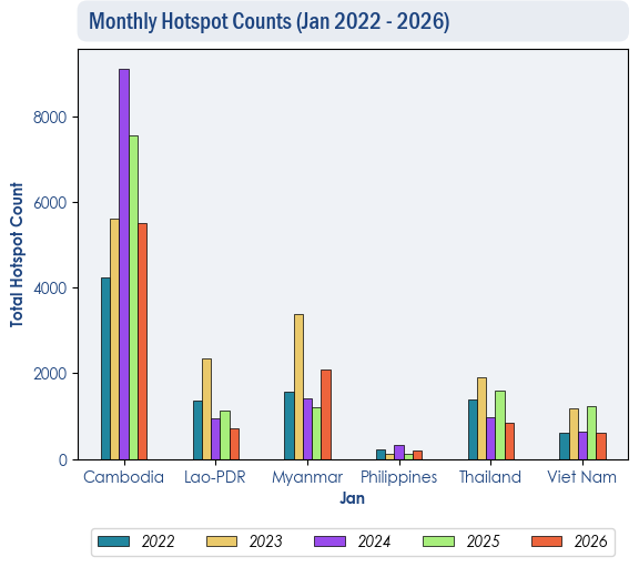
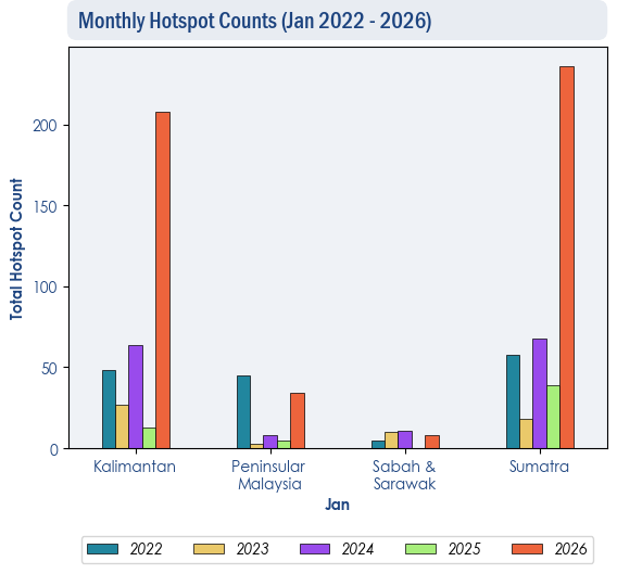
1.3 The hotspot counts over the northern ASEAN region were generally lower than or comparable to those recorded in the same month during previous years (Figure 2). Over the southern ASEAN region, the hotspot counts were mostly higher compared to previous years, especially over Kalimantan and Sumatra, where there was a significant increase in hotspot activity, with the highest count recorded in five years (Figure 3).


Figure 2: Hotspot counts for the northern ASEAN region for January (2022-2026) based on NOAA-20 satellite surveillance.


Figure 3: Hotspot counts for the southern ASEAN region for January (2022-2026) based on NOAA-20 satellite surveillance.


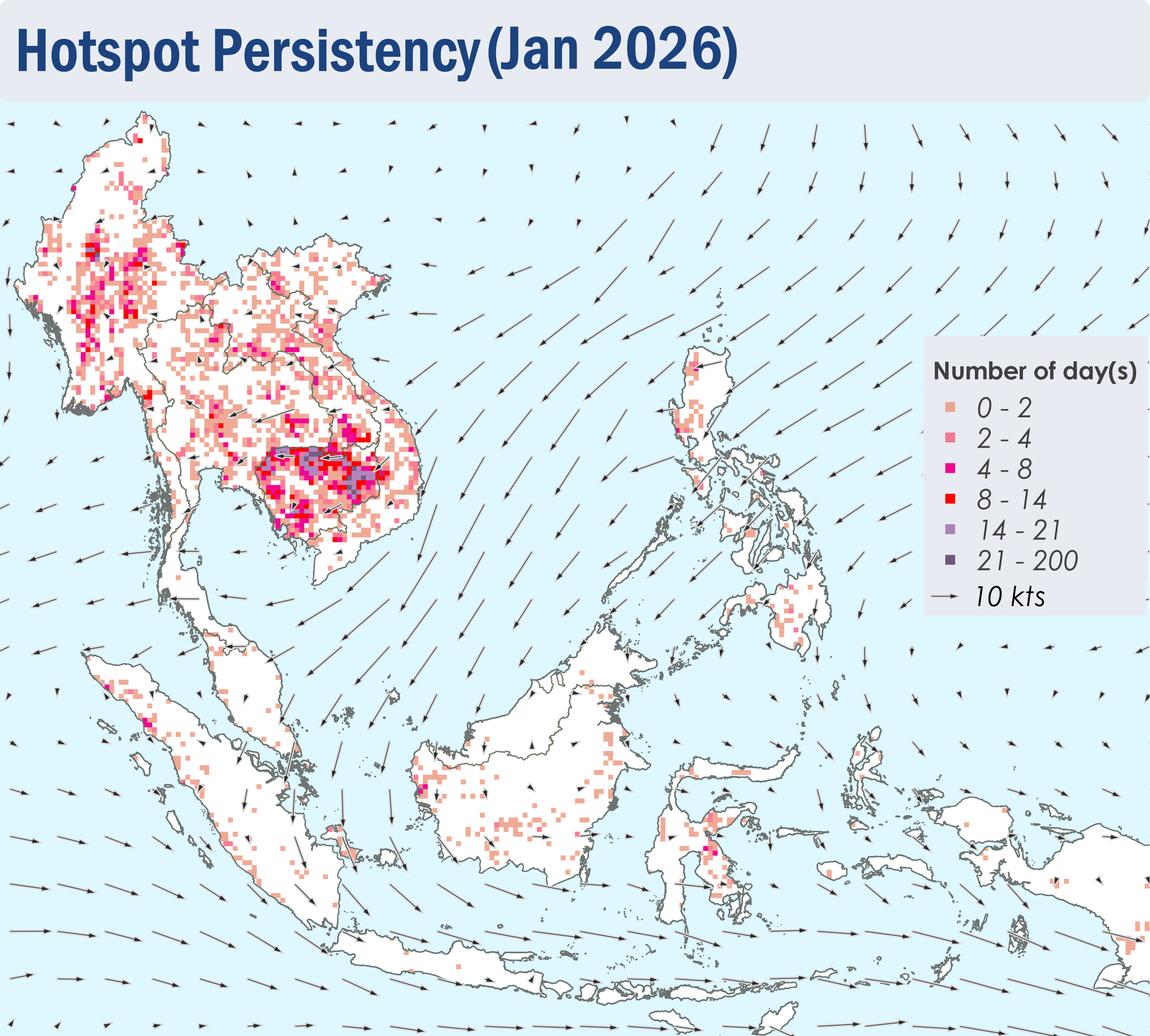
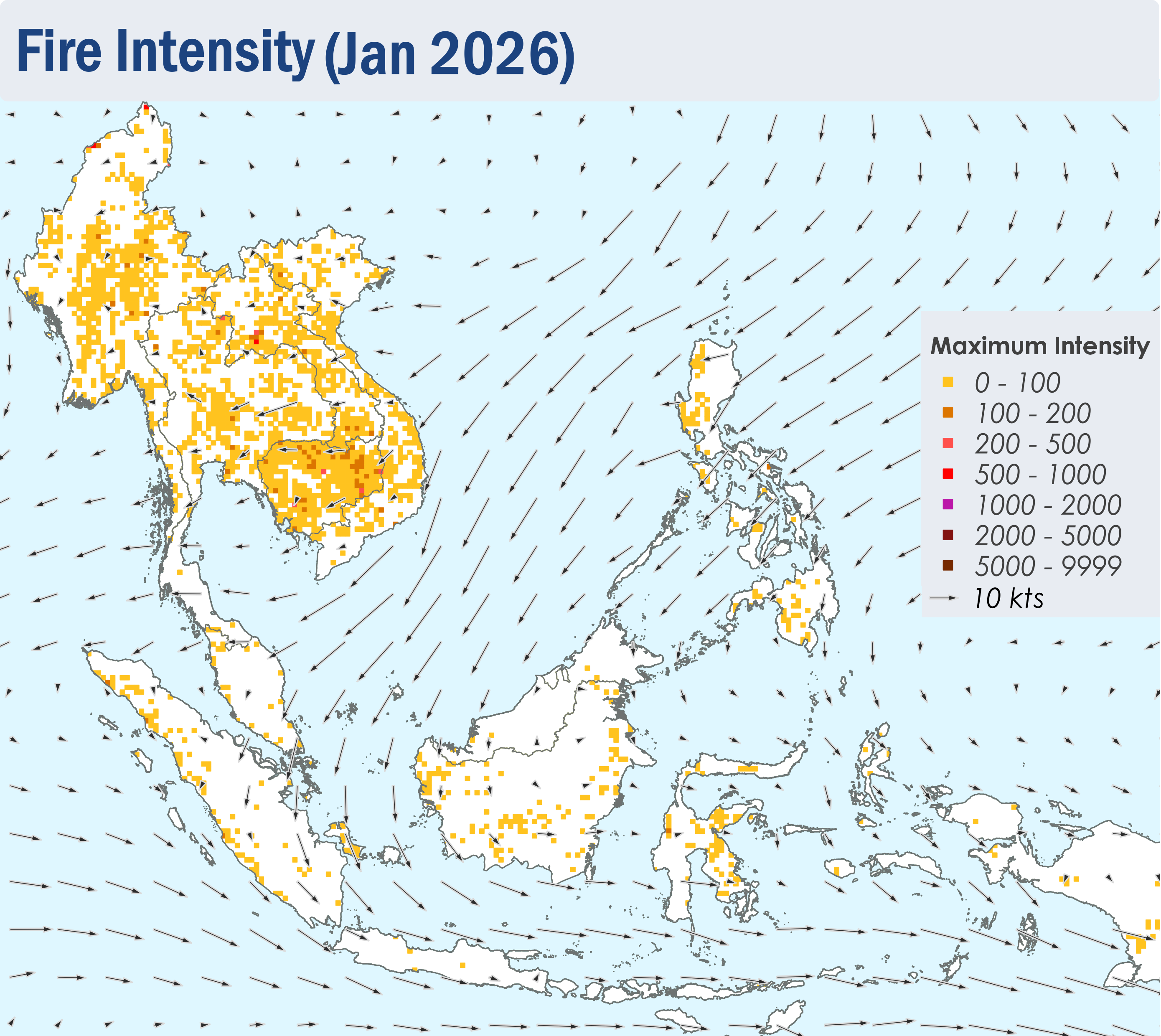
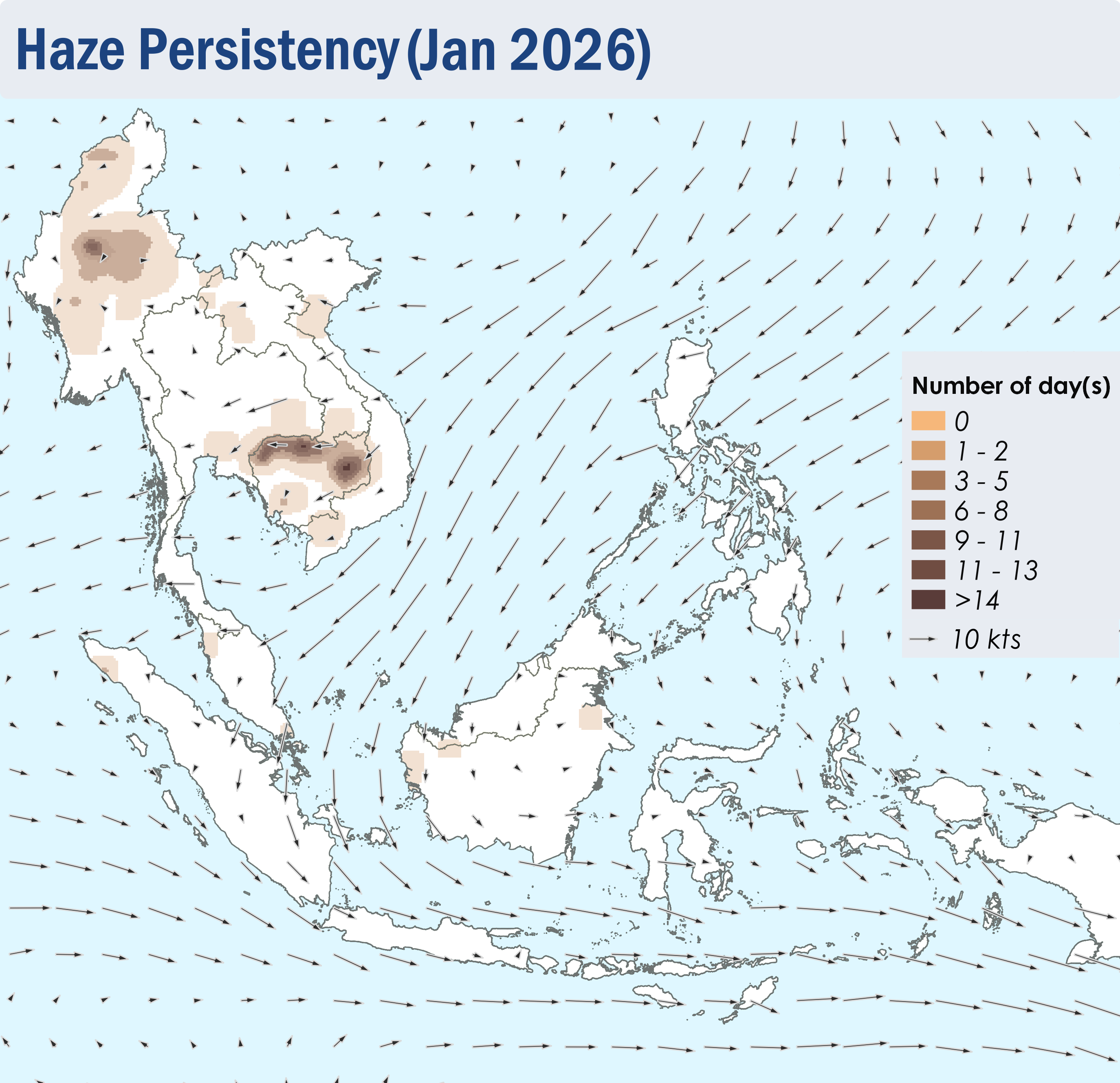
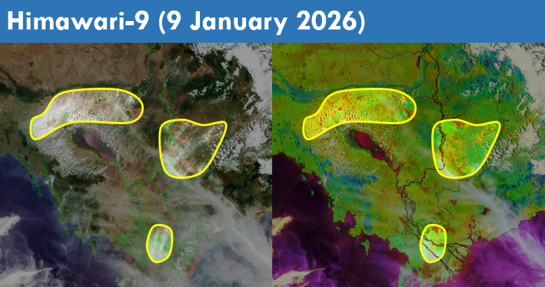
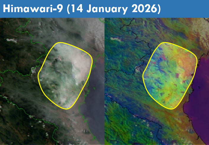
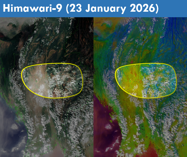
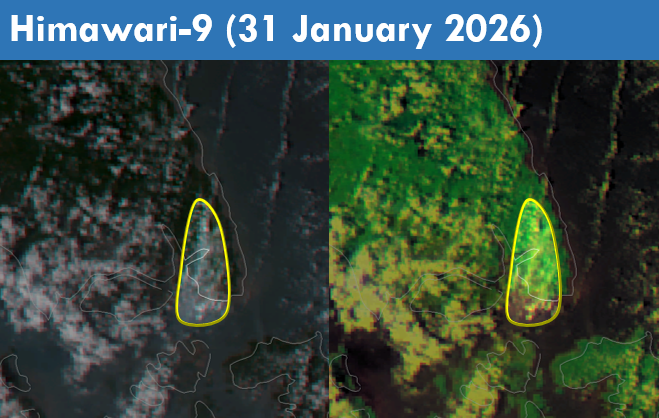
1.4 Persistent and intense hotspots were detected mostly in Cambodia, Myanmar and the southern parts of Lao PDR (Figures 4 and 5). During prolonged periods of dry weather, moderate and persistent smoke plumes were observed mainly over the central parts of Myanmar and the northern parts of Cambodia. Smoke plumes were also observed over the other parts of the Mekong sub-region, Sumatra, Peninsular Malaysia and Kalimantan (Figures 6 to 10).
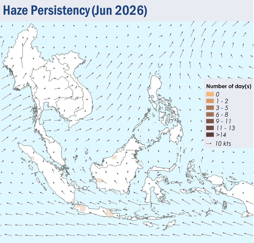
 

Figure 4: Distribution of hotspots detected in January 2026 based on NOAA-20 satellite surveillance.


Figure 5: Maximum fire intensity in January 2026 based on NOAA-20 satellite surveillance.


Figure 6: Number of days with moderate to dense smoke haze observed in January 2026 based on satellite imagery, ground observations, and air quality reports.


Figure 7: Slight to moderate localized smoke plumes observed over the northern and eastern parts of Cambodia, as well as the southern parts of Viet Nam on 9 January 2026. (Source: Himawari-9 satellite surveillance)


Figure 8: Slight to moderate localized smoke plumes observed over the northern parts of Viet Nam on 14 January 2026. (Source: Himawari-9 satellite surveillance)


Figure 9: Slight to moderate localized smoke plumes observed over the central parts of Myanmar on 23 January 2026. (Source: Himawari-9 satellite surveillance)


Figure 10: A moderate smoke plume observed over the eastern parts of Johor on 31 January 2026. (Source: Himawari-9 satellite surveillance)


January 12, 2026

Review of Regional Haze Situation for December 2025

Review of Regional Haze Situation for December 2025

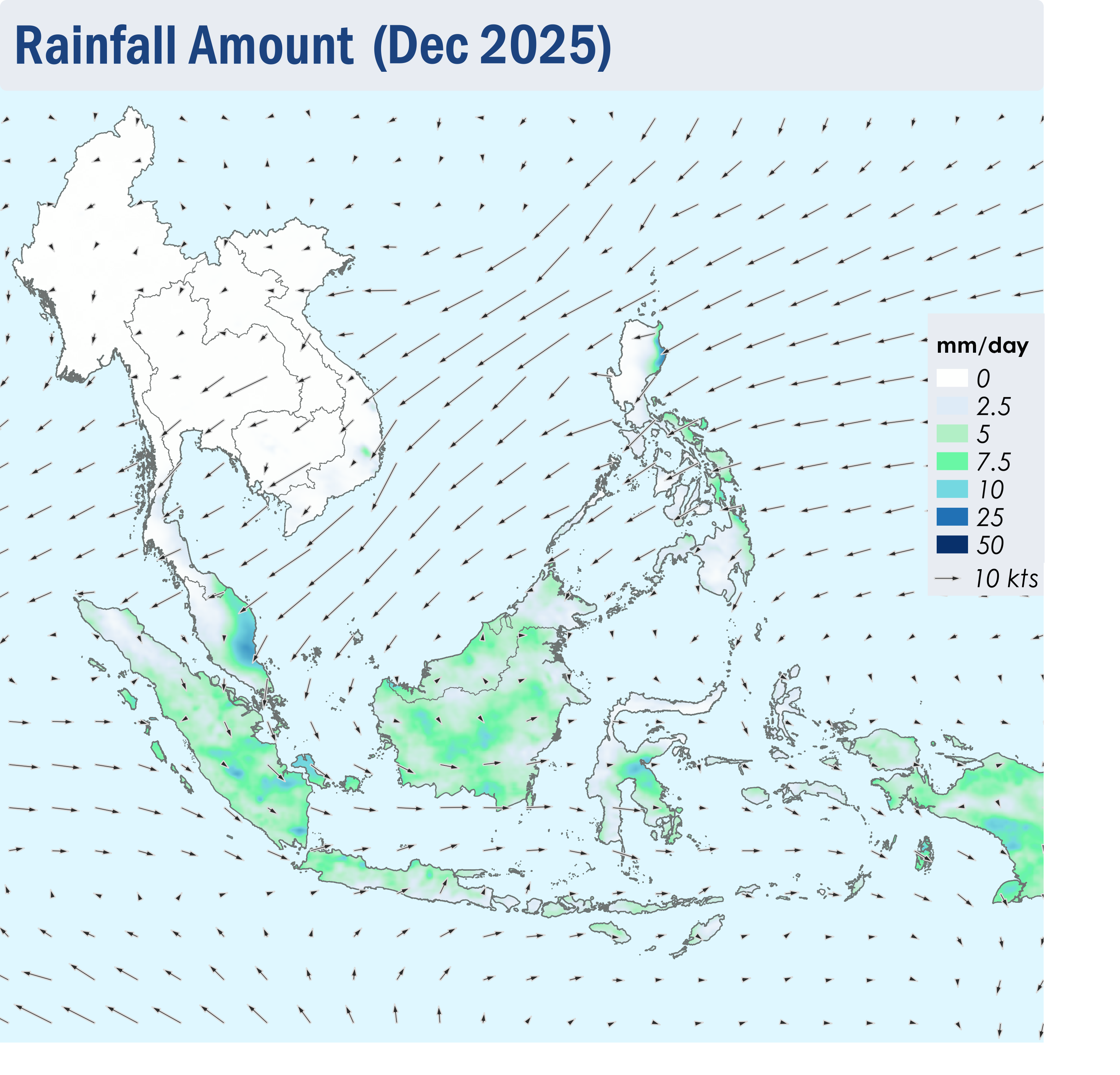
1.1 In December 2025, Northeast monsoon was well established over the ASEAN region as the prevailing low-level winds over most areas north of the Equator blew from the northeast or east except for the northern parts of the Mekong sub-region where the prevailing low-level winds were light and variable in direction. Over the areas south of the Equator, the prevailing low-level winds blew mainly from the west and northwest. (Figure 1).

1.2 Dry conditions were observed over most parts of the Mekong sub-region except for the coastal areas in the southern parts of Viet Nam where some showers were observed (Figure 1). In view of the expected persistence of the dry weather conditions across the sub-region, the Alert Level was activated to Level 1 for the northern ASEAN region, on 26 December 2025, to signal the start of its dry season. Wet weather was observed over the rest of the ASEAN region with intense rainfall recorded over the eastern parts of Peninsular Malaysia (Figure 1). Heavy rainfall was also recorded in the eastern parts of the Philippines (Figure 1) under the influence of Tropical Cyclone WILMA.

Figure 1: Average Daily Rainfall and Mean Winds for December 2025. (Source: JAXA GsMaP and GFS, respectively)


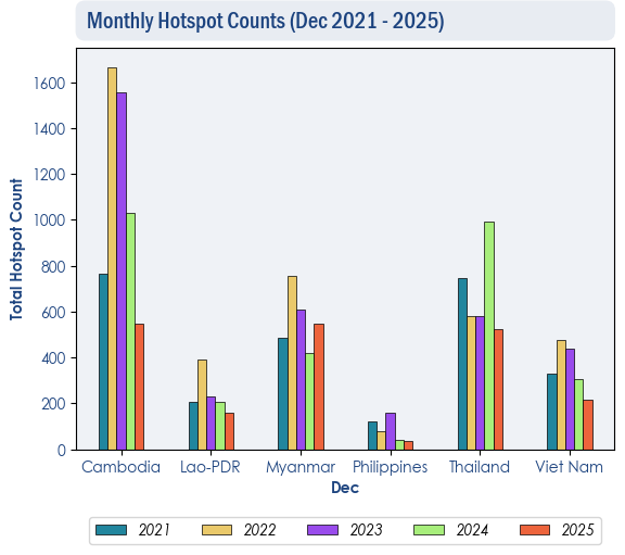
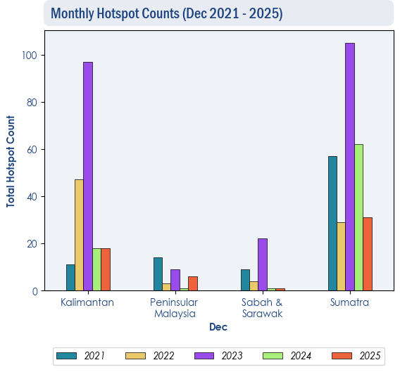
1.3 The overall hotspot counts in December 2025 over the ASEAN region were generally lower than or comparable to previous years.


Figure 2: Hotspot counts for the northern ASEAN region for December (2021-2025) based on NOAA-20 satellite surveillance.


Figure 3: Hotspot counts for the southern ASEAN region for December (2021-2025) based on NOAA-20 satellite surveillance.


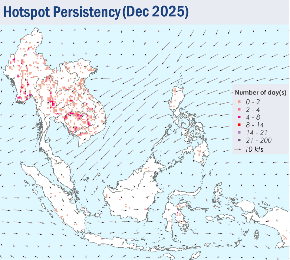
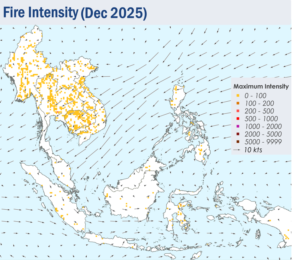
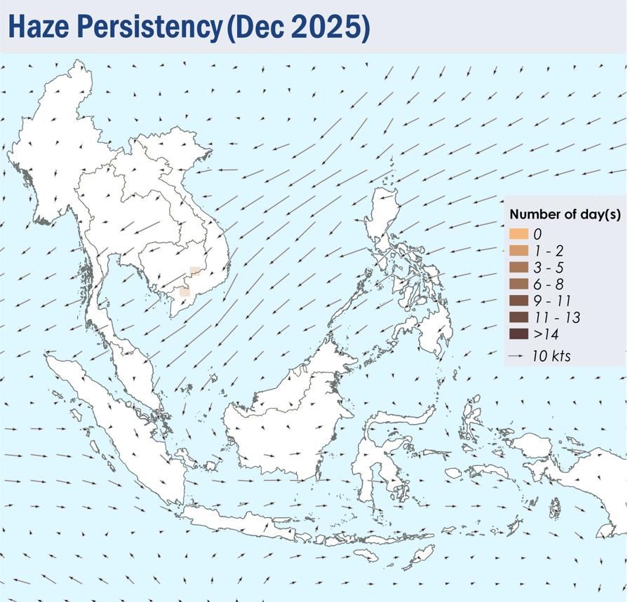
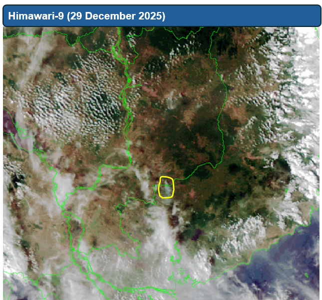
1.4 During the review period, isolated to scattered hotspots were detected in the Mekong sub-region (Figures 4 and 5). While most of the hotspots were short-lived, some hotspots in the central parts of Myanmar and Thailand, as well as parts of Cambodia, were persistent and intense. Moderate smoke plumes were observed to emanate from a few hotspots in the southeastern parts of Cambodia and in the southern parts of Viet Nam (Figures 6 and 7). A few slight localised smoke plumes were also observed to emanate from some hotspots detected in the Mekong sub-region. Although a few to isolated hotspots were detected in Sumatra and Kalimantan, the hotspot activities were generally subdued over the southern ASEAN region (Figure 4 and 5).
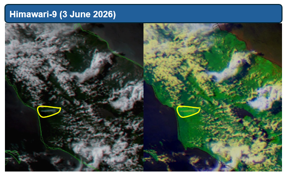
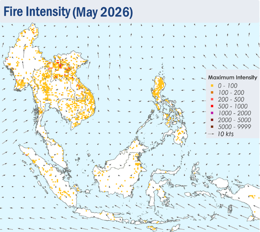
 

Figure 4: Distribution of hotspots detected in December 2025 based on NOAA-20 satellite surveillance.


Figure 5: Maximum fire intensity in December 2025 based on NOAA-20 satellite surveillance.


Figure 6: Number of days with moderate to dense smoke haze observed in December 2025 based on satellite imagery, ground observations, and air quality reports.


Figure 7: Moderate smoke plume observed over southeastern Cambodia on 29 December 2025, based on NOAA-20 satellite surveillance.


December 16, 2025

Review of Regional Haze Situation for November 2025

Review of Regional Haze Situation for November 2025

1.1 In November 2025, the inter-monsoon conditions gradually gave way to the Northeast Monsoon conditions over the ASEAN region as the prevailing winds were observed to blow from the northeast or east over most parts of the northern ASEAN region. However, light and variable prevailing winds were still observed to persist in most parts of the southern ASEAN region.

1.2 Dry conditions emerged over parts of the Mekong sub-region in November 2025 except for wet weather observed over the central and southern parts of Viet Nam. Increased rainfall amounts in Viet Nam and the Philippines were attributed to heavy showers caused by Typhoon Kalmaegi and Typhoon Fung-wong.

1.3 Widespread wet weather was observed to persist over the southern ASEAN region in November 2025. Heavier showers were also observed in the southern parts of Thailand and the northern parts of Sumatra due to Tropical Cyclone Senyar. Floods and landslides were reported in parts of Peninsular Malaysia, Indonesia and Thailand, leading to loss of lives and infrastructure damage.

Figure 1: Average Daily Rainfall and Mean Winds for November 2025. (Source: JAXA GsMaP and GFS, respectively)


1.4 The hotspot counts for the ASEAN region in November 2025 were lower than or comparable to the previous years (Figure 2 and 3).
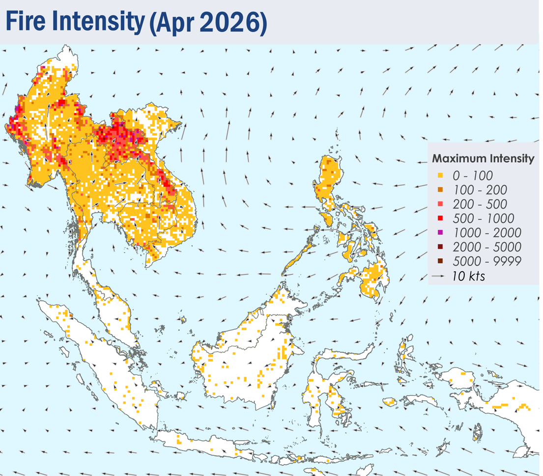
 

Figure 2: Hotspot counts for the southern ASEAN region for November (2021-2025) based on NOAA-20 satellite surveillance.
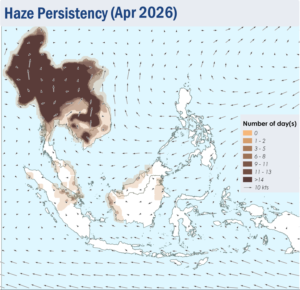
 

Figure 3: Hotspot counts for the northern ASEAN region for November (2021-2025) based on NOAA-20 satellite surveillance.


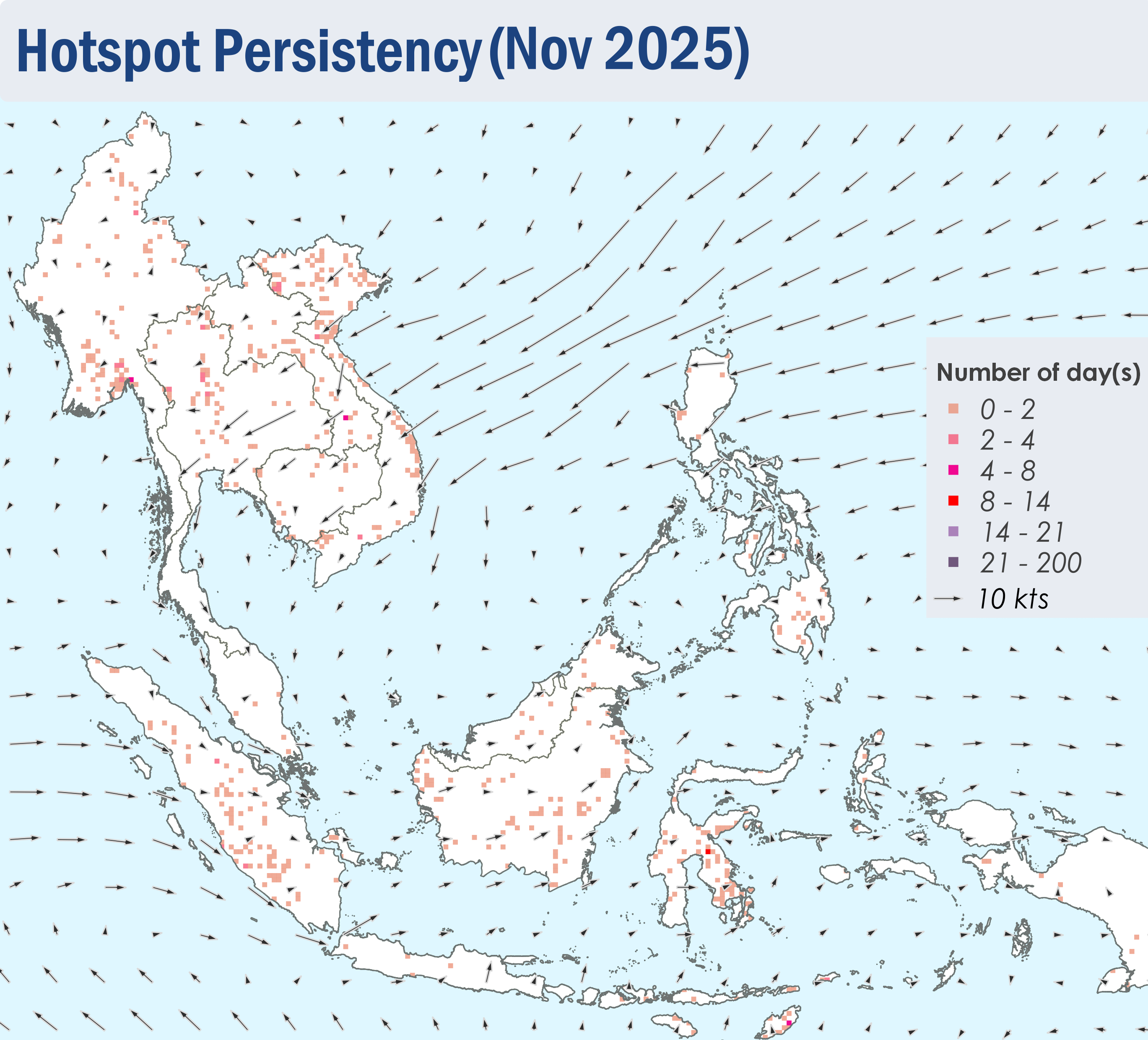
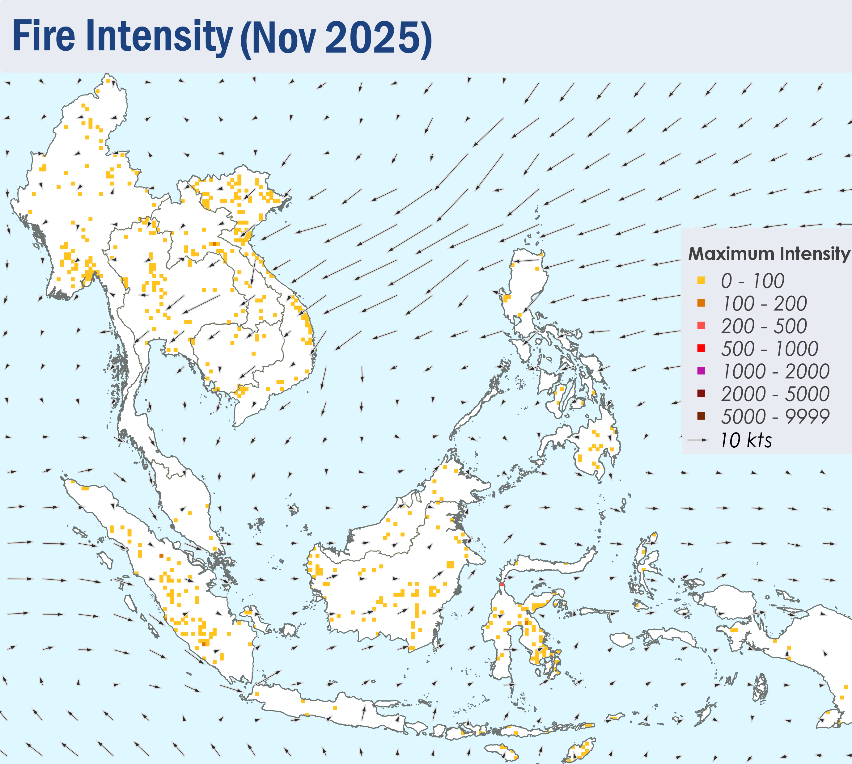
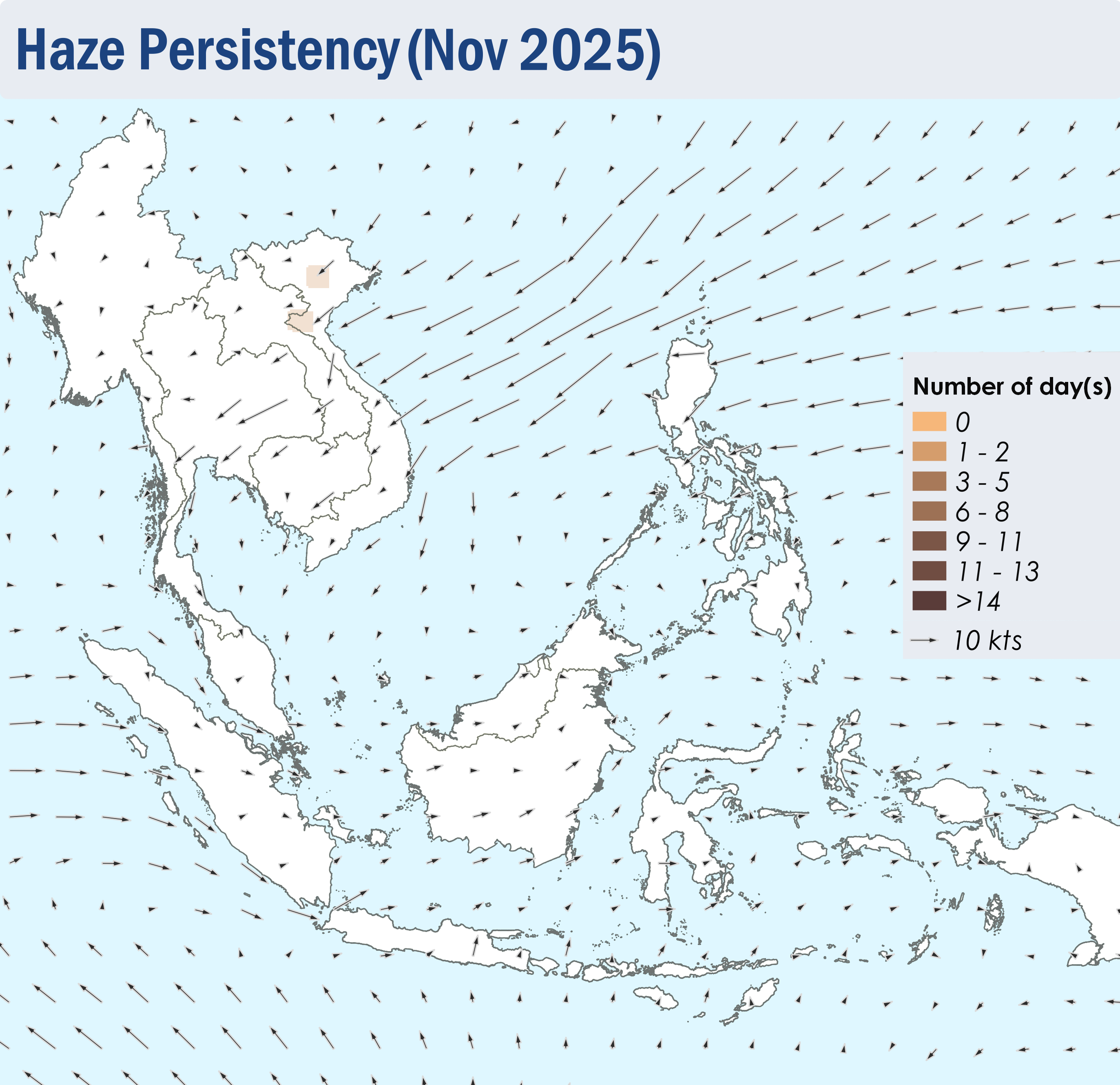
1.5 For the southern ASEAN region, isolated hotspots were detected in Sumatra and Borneo, with localised smoke plumes observed in parts of Kalimantan, Sabah and Sumatra on a few days. For the northern ASEAN region, a few to isolated hotspots were detected in many parts of the Mekong sub-region. Moderate smoke plumes were observed in the northern parts of Viet Nam on 24 November 2025 (Figure 6 and 7) and localised smoke plumes were observed emanating from isolated hotspots in parts of Myanmar, Thailand, Viet Nam and Lao PDR.


Figure 4: Distribution of hotspots detected in November 2025 based on NOAA-20 satellite surveillance.


Figure 5: Maximum fire intensity in November 2025 based on NOAA-20 satellite surveillance.


Figure 6: Number of days with moderate to dense smoke haze observed in November 2025 based on satellite imagery, ground observations, and air quality reports.


Figure 7: Slight to moderate smoke haze observed in the northern parts of Viet Nam on 24 November 2025. (Source: Himawari-8 satellite surveillance)