Monthly Archives: February 2021

February 26, 2021

Webinar on Fires/Smoke Haze Monitoring and Detection for the Mekong sub-region (12-13 January 2021)

ASMC Webinar on Fires/Smoke Haze Monitoring and Detection for the Mekong sub-region (12 – 13 January 2021)

ASMC conducted its first Webinar on “Fires/Smoke Haze Monitoring and Detection for the Mekong sub-region” on 12 – 13 January 2021, as part of ASMC’s 5-year Regional Capability Building Programme. The webinar welcomed a total of 15 participants from Myanmar, Cambodia and Thailand, and included lectures on the use of satellites for fires and haze monitoring, smoke haze dispersion modelling and seasonal and sub-seasonal predictions. The concepts were reinforced through case studies, and a virtual hands-on session facilitated by ASMC’s trainers. The webinar concluded with a review of the current weather and smoke haze situation and the outlook for the Mekong sub-region. The participants also discussed hotspot detection related issues associated with the transition from the use of NOAA-19 to the NOAA-20 satellite.

Figure 1: Examples of the poster and satellite images (with overlay grids) used during the webinar hands-on session where participants were invited to identify possible areas with smoke haze.

The workshop included lectures for participants to gain foundational understanding of topics such as weather systems in Southeast Asia, sub-seasonal and seasonal predictions, interpretation of satellite imageries, data analysis methodologies, and dispersion modelling as a predictive tool. The lectures were supplemented with hands-on exercises in interpretation of satellite data. The participants also had a short attachment at the ASMC Forecast Office, where they worked with ASMC meteorologists to carry out near real-time assessment of the fire and haze situation in the Mekong sub-region.

Figure 2: A sample of ASMC’s Haze dispersion modelling output of smoke haze in the ASEAN region.

Ms May Yadanar Oo, a webinar participant from the Ministry of Natural Resources and Environmental Conservation (MONREC), Myanmar shared that the topics presented in the webinar were relevant and useful, particularly the lectures on the detection of hotspot and smoke haze using satellites. She hoped that future webinars could continue to include similar topics.

ASMC will be conducting two more workshops in the first half of 2021 as part of ASMC’s 5-year (2018-2022) regional capability building efforts for the ASEAN region, namely the 3rd ASEAN Regional Climate Data, Analysis and Projections (ARCDAP-3) and the 2nd lecture series on Weather Prediction by Numerical Methods (WPNM-M2).

Figure 3: Snapshots of some participants with ASMC trainers at the ASMC Webinar on “Fires/Smoke Haze Monitoring and Detection for Mekong sub-region” held on 12 – 13 January 2021.

Review of Regional Haze Situation for January 2021

Review of Regional Haze Situation for January 2021

1.1 Northeast Monsoon conditions prevailed over the ASEAN region in January 2021. In the northern ASEAN region, the prevailing winds blew mainly from the northeast or east, strengthening at times under the influence of high-pressure systems moving eastwards over continental Asia. Dry conditions persisted over the Mekong sub-region while wet weather conditions were observed mostly over the eastern parts of the Philippines. In the southern ASEAN region, the prevailing winds blew mainly from the northwest or northeast over areas near the Equator, and mainly from the west or northwest over areas south of the Equator. There were isolated to scattered shower activities over the region, with rainfall observed to be higher over parts of Malaysia, Singapore, North Kalimantan, central Sumatra, and Java Island.

Figure 1: Average Daily Rainfall and Mean Wind for January 2021. (Source: JAXA GsMaP and GFS respectively)

 
1.2 The hotspot counts in the ASEAN region for January 2021 were comparatively lower than those from the same review period in previous years, with the exception of Myanmar (Figure 2 and Figure 3).

Figure 2: Hotspot counts for the northern ASEAN region for the month of January (2017 – 2021). [Note: The hotspot counts from 2019 onwards are based on the NOAA-20 satellite, while those from 2017 – 2018 are based on the Suomi-NPP satellite.]

Figure 3: Hotspot counts for the southern ASEAN region for the month of January (2017 – 2021). [Note: The hotspot counts from 2019 onwards are based on the NOAA-20 satellite, while those from 2017 – 2018 are based on the Suomi-NPP satellite.]


1.3 In the northern ASEAN region, hotspot activities were detected in many parts of the Mekong sub-region. In particular, persistent clusters of hotspots were detected in the northeastern parts of Myanmar, and the northern and eastern parts of Cambodia (Figure 4 and Figure 5). During the first fortnight of the month, moderate smoke haze was first observed to emanate from the hotspot clusters in the northern and eastern parts of Cambodia (Figure 6).

1.4 In view of the prolonged dry conditions, increased hotspot activities and persistent hotspot clusters in the Mekong sub-region, the Alert Level was raised to Level 2 for the sub-region on 14 January 2021. The hotspot and haze situation in the Mekong sub-region further deteriorated during the second fortnight of the month when moderate smoke haze was observed over larger areas of Cambodia, as well as over parts of Thailand and Myanmar (Figure 6). In particular, dense smoke haze was detected over the northern and eastern parts of Cambodia towards the end of the month. In the southern ASEAN region, hotspot activities were subdued due to the wet weather conditions.

Figure 4: Distribution of hotspots detected based on NOAA-20 satellite surveillance for January 2021.


Figure 5: Maximum fire intensity based on NOAA-20 satellite surveillance for January 2021.

Figure 6: Number of days with moderate to dense smoke haze observed over an area based on satellite imagery, ground observations and air quality reports in January 2021.


February 19, 2021

Subseasonal Weather Outlook (22 February – 7 March 2021)

Subseasonal Weather Outlook (22 February – 7 March 2021)

Issued 19 February 2021
First forecast week: 22 February – 28 February
Second forecast week: 1 March – 7 March

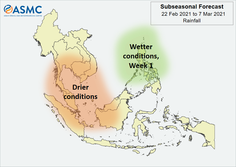
figure1

Figure 1: Rainfall Outlook

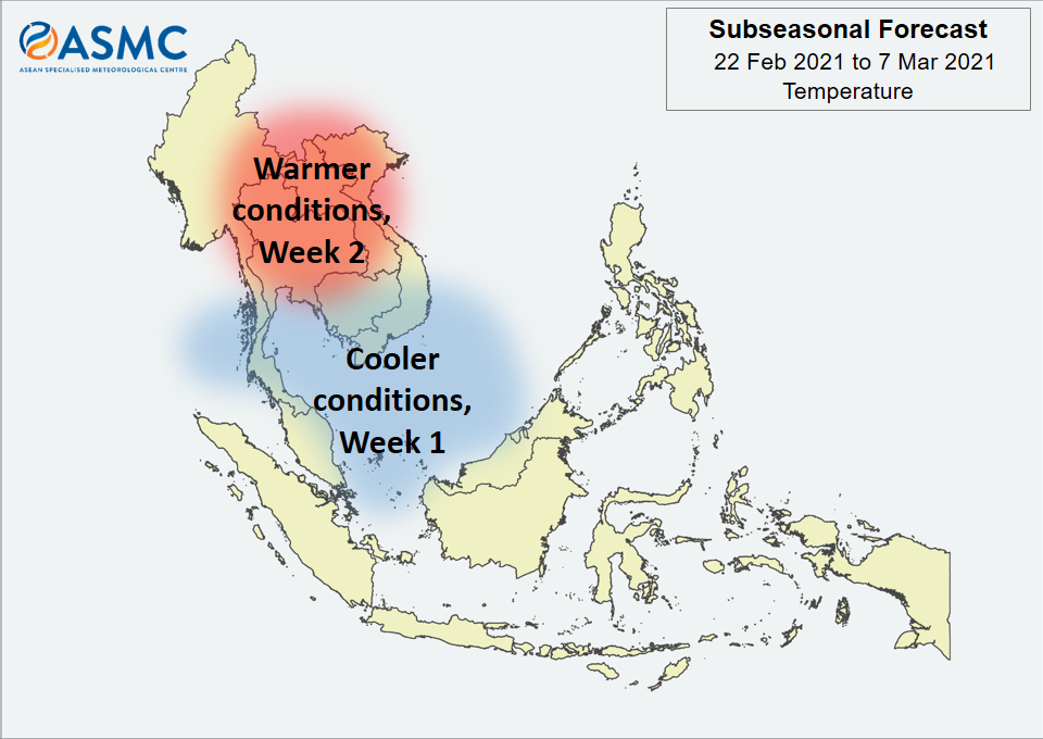
figure2

Figure 2: Temperature Outlook


Drier conditions are expected over the western Maritime Continent and southern Mainland Southeast Asia in Week 1 (22 – 28 February). There is a chance of these drier conditions persisting through Week 2 (1 – 7 March), although with lower confidence than Week 1. Wetter conditions are expected over central and northern Philippines in Week 1, but the location is highly dependent on tropical cyclone development.

Cooler temperatures than usual are expected around the Gulf of Thailand and southern parts of South China Sea, including southern Viet Nam, southern Cambodia, and the eastern coast of the Malay Peninsula in Week 1 (22 – 28 February). Warmer conditions than usual are expected over central Mainland Southeast Asia in Week 2 (1 – 7 March).

There are signs that an MJO signal is currently present over the Western Pacific (Phase 7), although the models are predicting this signal to rapidly weaken in Week 1. Some models are predicting another MJO to develop in Week 2 (Phase 7 or 8) and continue propagating eastward.

The outlook is assessed for the region in general, where conditions are relative to the average conditions for the corresponding time of year. For specific updates on the national scale, the relevant ASEAN National Meteorological and Hydrological Services should be consulted.

February 18, 2021

Review of Regional Weather for January 2021

Review of Regional Weather for January 2021

1. Overview

1.1 During January 2021, much of the Maritime Continent received more rainfall than average for this time of year (Figure 1). The exceptions were Sumatra and central parts of Borneo and Papua, which received a mix of below- to above-average rainfall. The largest positive anomalies (wetter conditions) were recorded over Peninsular Malaysia, northern Borneo, and Nusa Tenggara based on both satellite-derived rainfall estimates datasets (GSMaP-NRT and CMORPH-Blended). For the rest of Mainland Southeast Asia, rainfall anomalies were negligible, as expected at during dry season for the northern ASEAN region.

1.2 The observed large-scale rainfall anomaly pattern (i.e. above-average rainfall in parts of the Maritime Continent, in particular southern Indonesia, northern Borneo and the Philippines) is broadly consistent with the predictions from the subseasonal weather outlooks for January 2021 (28 Dec – 10 Jan, 11 – 24 Jan, 25 Jan – 7 Feb).

era5_rainfall_anomalies
cmorph_bld_rainfall_anomalies
Figure 1: Rainfall anomalies for the month of January 2021 based on GSMaP-NRT data (left) and CMORPH-Blended data (right). The climatological reference period is 2001-2020. Green colour denotes above-average rainfall (wetter), while orange denotes below-average rainfall (drier).


1.3 Colder-than-average temperatures (more than 1°C cooler) were recorded over most of Mainland Southeast Asia in January 2021 (Figure 2). In contrast, warmer-than-average temperatures (more than 1°C warmer) were recorded over parts of Myanmar. Over the Maritime Continent, temperatures were closer to average, with near- to above-average temperature in eastern part, and below- to near-average temperatures in the western and central parts.

era5_temperature_anomalies


Figure 2: Temperature anomalies for the month of January 2021 based on ERA-5 reanalysis. The climatological reference period is 2001-2020. Red colour denotes above-average temperature (warmer), while blue denotes below-average temperature (colder).


2. Climate Drivers

2.1 While there were some signs that a weak Madden-Julian Oscillation (MJO) signal was present in the Indian Ocean (Figure 3, Phase 3) in the first week of January 2021, this signal weakened as it moved towards the Maritime Continent. In the second half of the month, a moderate strength, very slow-moving MJO signal appeared in the Western Pacific (Phases 6 and 7), although there was no notable eastward progression. Phase 6 typically brings wetter conditions to the eastern-most part of the Maritime Continent, while Phase 7 typically brings drier conditions to the western half of the Maritime Continent at this time of year.

mjo_phase_diagram


Figure 3: The MJO phase diagram. The diagram illustrates the movement of the MJO through different phases, which correspond to different locations along the equator (denoted in the text with the first day of the month in blue and the last day of the month in red). The distance of the index from the centre of the diagram is related to the strength of the MJO. Values within the grey circle are considered weak or indiscernible (data from the Bureau of Meteorology, Australia).


2.2 Over the tropical Pacific Ocean, La Niña conditions were present. The sea surface temperatures in the central and eastern Pacific Ocean remained cool, with atmospheric indicators (cloudiness and wind anomalies) also remaining consistent with La Niña conditions. La Niña events tend to bring wetter-than-average conditions to much of Southeast Asia during the September to March period.

February 5, 2021

Subseasonal Weather Outlook (8 – 21 February 2021)

Subseasonal Weather Outlook (8 – 21 February 2021)

Issued 5 February 2021
First forecast week: 8 February – 14 February
Second forecast week: 15 February – 21 February

figure1

Figure 1: Rainfall Outlook

figure2

Figure 2: Temperature Outlook


Wetter conditions are expected over the Philippines and northern Borneo in the next fortnight (8 – 21 February). In Week 1 (8 – 14 February), there is an increased chance of wetter conditions over north-eastern Mainland Southeast Asia, as well as over southern Indonesia. In Week 2 (15 – 21 February), drier conditions are expected over the Malay Peninsula and western Borneo.

Warmer conditions than usual are expected over much of the Maritime Continent in Week 1 (8 – 14 February). Cooler temperatures than usual are expected over western Mainland Southeast Asia in Week 1, in particular Myanmar, northern Thailand and northern Lao PDR.

An MJO signal is currently present over the Western Pacific (Phase 6). The models are predicting a slow eastward propagation of the MJO, moving into Phase 7 in Week 1. In Week 2, models are either predicting the MJO to decay or continue slowly propagating eastward.
 
The outlook is assessed for the region in general, where conditions are relative to the average conditions for the corresponding time of year. For specific updates on the national scale, the relevant ASEAN National Meteorological and Hydrological Services should be consulted.