Monthly Archives: June 2021

June 25, 2021

Subseasonal Weather Outlook (28 June – 11 July 2021)

Subseasonal Weather Outlook (28 June – 11 July 2021)

Issued 25 June 2021
First forecast week: 28 June – 4 July
Second forecast week: 5 July – 11 July

figure1

Figure 1: Rainfall Outlook

figure2

Figure 2: Temperature Outlook


Wetter conditions are expected over the southern parts of the Maritime Continent in Week 1 (28 June – 4 July). In Week 2 (5 – 11 July), there is an increased chance of wetter conditions continuing, particularly over the southeastern parts of the Maritime Continent.

In Week 1 (28 June – 4 July), drier conditions are expected over much of the northern ASEAN region. Most of this region is expected to transition to wetter conditions in Week 2 (5 – 11 July) except for coastal regions of Myanmar where the drier conditions are expected to persist.

Warmer temperatures than usual are expected over much of Mainland Southeast Asia in the next fortnight (28 June – 11 July), although these warmer conditions may ease over its eastern parts in Week 2 (5 – 11 July), coinciding with the wetter conditions.

A less coherent MJO signal was present over the Western Hemisphere and Africa (Phase 1) towards the end of June. There is disagreement between the models regarding the MJO’s development. Some models predict the MJO to continue propagating eastwards and strengthen over the Maritime Continent (Phases 4 and 5).
 
The outlook is assessed for the region in general, where conditions are relative to the average conditions for the corresponding time of year. For specific updates on the national scale, the relevant ASEAN National Meteorological and Hydrological Services should be consulted.

June 16, 2021

Review of Regional Haze Situation for May 2021

Review of Regional Haze Situation for May 2021

1.1 Inter-monsoon conditions prevailed over most of the ASEAN region in May 2021. While most of the region experienced light and variable winds, the prevailing winds over Java, the Lesser Sunda Islands, the Philippines, and Sulawesi blew from the east or southeast.

1.2 During this period, shower activities were observed over most of the ASEAN region. However, drier conditions persisted in the Lesser Sunda Islands and eastern Java (Figure 1).

Figure 1: Average Daily Rainfall and Mean Wind for May 2021. (Source: JAXA GsMaP and GFS respectively)


1.3 For the May review period, the hotspot counts over the ASEAN region for 2021 were slightly lower or comparable to those in previous years (Figures 2 and 3).

Figure 2: Hotspot counts for the northern ASEAN region for the month of May (2017 – 2021). [Note: The hotspot counts from 2019 onwards are based on the NOAA-20 satellite, while those from 2017 – 2018 are based on the Suomi-NPP satellite.]


Figure 3: Hotspot counts for the southern ASEAN region for the month of May (2017 – 2021). [Note: The hotspot counts from 2019 onwards are based on the NOAA-20 satellite, while those from 2017 – 2018 are based on the Suomi-NPP satellite.]


1.4 Although hotspot activities were detected in most parts of the ASEAN region, no significant smoke haze was observed in May 2021. Isolated hotspots were detected in most of the southern ASEAN region, contributed by the development of drier conditions there. In the northern ASEAN region, although some hotspot clusters were detected, an increase in shower activities throughout the month led to a gradual improvement of the hotspot situation. ASMC declared the end of the northern ASEAN dry season on 21 May 2021 with the downgrading of Alert Level 1 to Alert Level 0 (Figures 4 and 5).

Figure 4: Distribution of hotspots detected in March 2021 based on NOAA-20 satellite surveillance.


Figure 5: Maximum fire intensity in March 2021 based on NOAA-20 satellite surveillance.


June 14, 2021

Review of Regional Weather for May 2021

Review of Regional Weather for May 2021

1. Overview

1.1 During May 2021, there was a mix of below- to above-average rainfall over the ASEAN region. For the equatorial region, the GSMaP-NRT dataset (Figure 1a) shows near- to above-average rainfall (except for parts of central Borneo), while the CMORPH-Blended dataset (Figure 1b) shows a mixture of below- and above-average rainfall. The largest positive anomalies (wetter conditions) were recorded over southern Philippines for both satellite-derived rainfall estimates datasets, due to Tropical Depression 03W. Elsewhere in the Maritime Continent, the southern Maritime Continent and northern Philippines experienced below-average rainfall, with the largest negative anomalies (drier conditions) recorded over northern Philippines. For Mainland Southeast Asia, parts of central Mainland Southeast Asia experienced below-average rainfall, with CMORPH-Blended showing a larger proportion of Thailand receiving below-average rainfall, while GSMaP-NRT extended the below-average rainfall over coastal Myanmar. Near- to above-average rainfall was experienced elsewhere in Mainland Southeast Asia.
 

1.2 The observed rainfall anomaly pattern (i.e. below-average rainfall over southern Maritime Continent, above-normal rainfall in the equatorial region) is broadly consistent with the predictions from the subseasonal weather outlooks for May 2021 (3 – 16 May, 17 – 30 May).

era5_rainfall_anomalies
cmorph_bld_rainfall_anomalies
Figure 1: Rainfall anomalies for the month of May 2021 based on GSMaP-NRT data (left) and CMORPH-Blended data (right). The climatological reference period is 2001-2020. Green colour denotes above-average rainfall (wetter), while orange denotes below-average rainfall (drier).


1.3 Most of Mainland Southeast Asia experienced above-average temperatures during May 2021, except for parts of Myanmar, Cambodia, and southern Viet Nam (Figure 2). Above-average temperatures were also experienced in northern Philippines and the southern Maritime Continent. Elsewhere, near-average temperatures were experienced, apart from below-average temperature for southern Philippines associated with the heavy rainfall.

era5_temperature_anomalies


Figure 2: Temperature anomalies for the month of May 2021 based on ERA-5 reanalysis. The climatological reference period is 2001-2020. Red colour denotes above-average temperature (warmer), while blue denotes below-average temperature (colder).


2. Climate Drivers

2.1 At the start of May 2021, a strong Madden-Julian Oscillation (MJO, Figure 3) signal was present in Phase 1 (Western Hemisphere). The signal then propagated eastward into the Indian Ocean (Phases 2 and 3), where it became less coherent for some time before strengthening again and propagating eastwards to the Maritime Continent (Phases 4 and 5). It subsequently weakened upon approaching Phase 6 with no coherent MJO signal for the rest of the month based on the RMM index. Phases 3 and 4 tend to bring wetter conditions to much of the Maritime Content, Phase 5 tends to bring wetter conditions to the eastern half of the Maritime Content, while Phase 6 tends to bring drier conditions to the western half of the Maritime Continent.

mjo_phase_diagram


Figure 3: The MJO phase diagram. The diagram illustrates the movement of the MJO through different phases, which correspond to different locations along the equator (denoted in the text with the first day of the month in blue and the last day of the month in red). The distance of the index from the centre of the diagram is related to the strength of the MJO. Values within the grey circle are considered weak or indiscernible (data from the Bureau of Meteorology, Australia).


2.2 Over the tropical Pacific Ocean, La Niña conditions decayed and returned to ENSO-neutral conditions by the beginning of June. The sea surface temperatures in the central and eastern Pacific Ocean continued to warm, with atmospheric indicators (cloudiness and wind anomalies) remaining consistent with the ENSO-neutral conditions.

June 11, 2021

Subseasonal Weather Outlook (14 – 27 June 2021)

Subseasonal Weather Outlook (14 – 27 June 2021)

Issued 11 June 2021
First forecast week: 14 June – 20 June
Second forecast week: 21 June – 27 June

figure1

Figure 1: Rainfall Outlook

figure2

Figure 2: Temperature Outlook


In Week 1 (14 – 20 June), wetter conditions are expected to develop over the western coastal region of Myanmar before transiting to drier conditions in Week 2 (21 – 27 June).

Over much of the rest of the northern ASEAN region, there is an increased chance of drier conditions than usual during the next fortnight (14 – 27 June).

Warmer temperatures than usual are expected over much of the southern parts of the Maritime Continent in the next fortnight (14 – 27 June). Warmer conditions may also develop over much of Mainland Southeast Asia, particularly inland areas, in Week 2 (21 – 27 June).

The MJO signal was no longer discernable based on the RMM Index. Some models predict an MJO signal to emerge either in the Western Hemisphere and Africa (Phases 8 and 1) or the Indian Ocean (Phases 2 and 3) during the forecast period.
 
The outlook is assessed for the region in general, where conditions are relative to the average conditions for the corresponding time of year. For specific updates on the national scale, the relevant ASEAN National Meteorological and Hydrological Services should be consulted.

June 2, 2021

16th ASEAN COF (May 2021, Online)

Sixteenth Session of the ASEAN Climate Outlook Forum (ASEANCOF-16)

image_gallery

20, 24 May 2021, ASEAN Specialised Meteorological Centre
 

Consensus Bulletin for June-July-August (JJA) 2021 Season

The ASEAN Climate Outlook Forum (ASEANCOF) is an avenue to collaboratively develop consensus-based seasonal climate outlooks and related information on a regional scale. The forum’s outlook and its activities contribute significantly to one of the key roles of the ASEAN Specialised Meteorological Centre (ASMC), which is to conduct climate and seasonal prediction for the ASEAN region through pooling the expertise of ASEAN National Meteorological and Hydrological Services (NMHSs). In 2021, the ASEANCOF Working Group was established with the goal to guide and support the long-term development of ASEANCOF, in particular with regard to the implementation of objective outlooks.

The sixteenth session of ASEANCOF (ASEANCOF-16) was organised by the ASEAN Specialised Meteorological Centre (ASMC) in collaboration with the ASEANCOF Working Group. Representatives from the NMHSs of ASEAN Member States created a consensus forecast for the boreal summer monsoon 2021 in the ASEAN region. The consensus for June-July-August (JJA) 2021 outlooks was achieved through an online session, which included presentations from NMHSs, questionnaires and discussions regarding the current conditions and predictions for the Southeast Asia region. In particular, the forum considered the possible influence of the El Niño Southern Oscillation (ENSO) and the Indian Ocean Dipole (IOD) on the climate system over Southeast Asia.

image_gallery


Conditions and Outlook

Recent analyses of sea surface temperature (SST) anomalies over the equatorial Pacific indicated near- to below-average SSTs across most of the central and eastern tropical Pacific Ocean and that the previous La Niña event has weakened. Most ENSO indicators are now in line with ENSO-neutral conditions.

The international climate outlooks predict ENSO-neutral conditions are likely to prevail during JJA 2021. After JJA 2021, there is uncertainty whether ENSO neutral conditions will persist, or for La Niña conditions to re-develop.

The current Indian Ocean Dipole (IOD) state is neutral and is expected to remain neutral for most of JJA 2021. There is a small increase in chance that a negative IOD event may develop in the second half of the year.
The onset of the Southwest (SW) Monsoon season is expected to be near-normal (typical) for much of the region, although may be slightly delayed for some northern regions.

Over much of Southeast Asia, the strength of the SW monsoon is expected to be near-normal. The development of a negative IOD event may increase the monsoon strength later in the outlook period. Furthermore, models are predicting the West Pacific Subtropical High to be displaced northward, which would bring near- to above-normal SW monsoon conditions to the Philippines.

Overall, the tropical cyclone frequency is expected to be below-average for the Bay of Bengal, while near- to above-average around the West Philippine Sea/South China Sea and the Western North Pacific (WNP). This is due to ENSO-neutral conditions as well as model predictions where above-average tropical cyclone activity in the WNP is forecasted during JJA 2021 with north-westward moving tracks.

Taking into consideration the national level forecasts, the present state of the climate, and the forecasts available from the GPCs and other global centres, the forum agreed on the following consensus-based outlook for JJA 2021 for the Southeast Asia region:
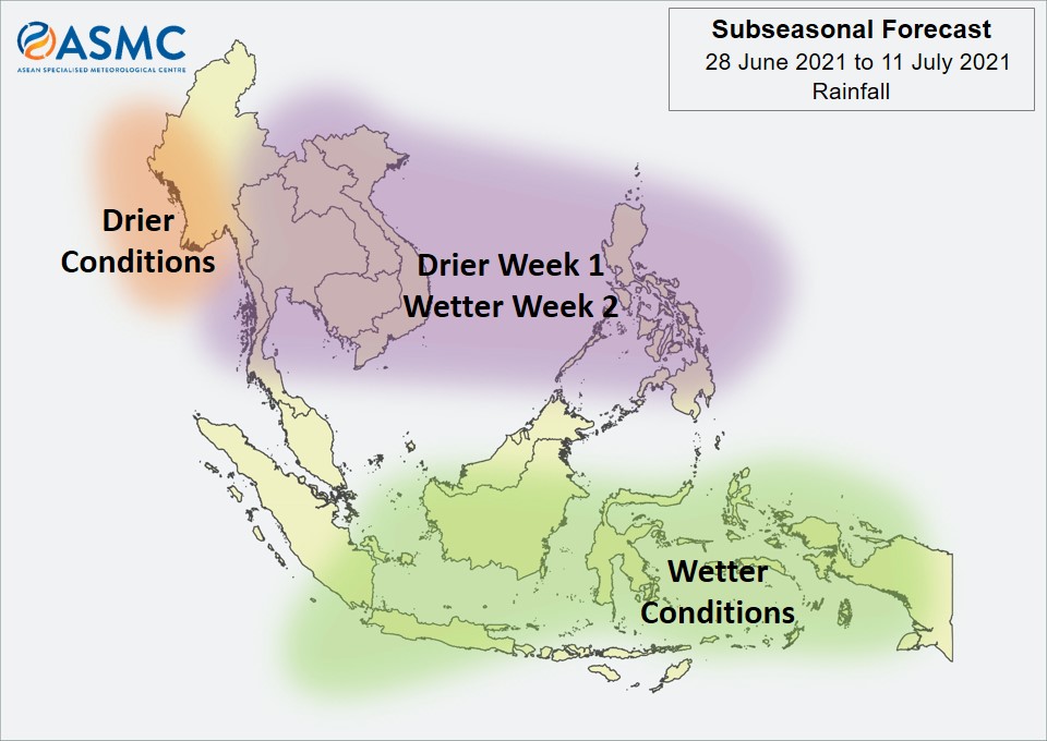
RAINFALL

For the upcoming boreal (Northern Hemisphere) summer season (June-July-August 2021), near-normal rainfall is expected for much of the region, including Myanmar, Thailand, Malaysia, Viet Nam, Brunei Darussalam, and northern Philippines.

Near- to above-normal rainfall is expected for parts of the Maritime Continent, including Singapore and central and southern Philippines.
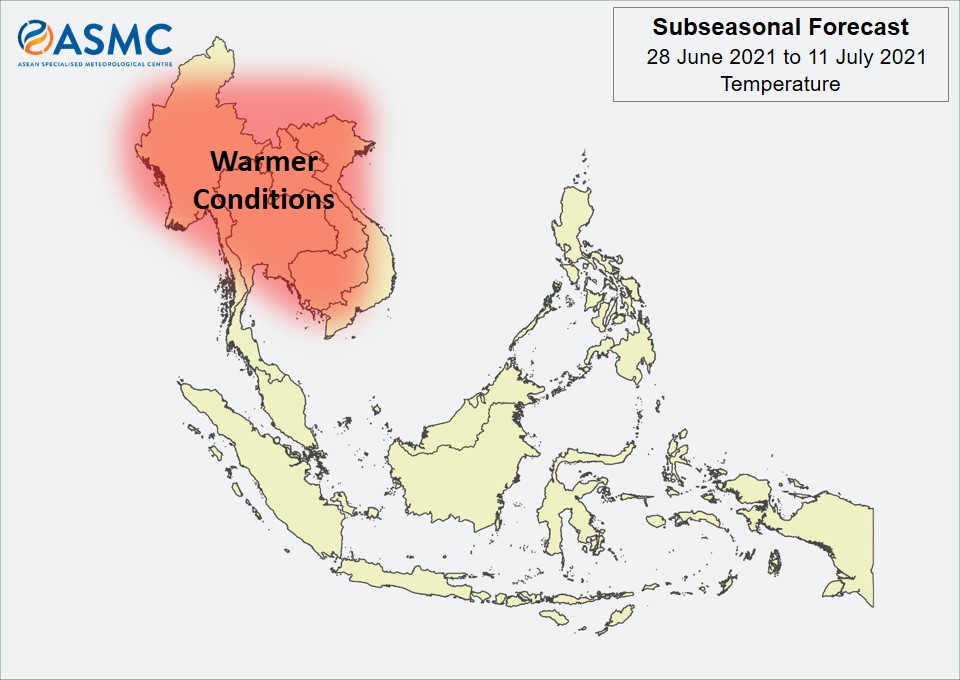
TEMPERATURE

Near- to above-normal temperature is predicted over Southeast Asia for the June-July-August 2021 season. The regions with the highest likelihood of above-normal temperature includes central Myanmar, Malaysia, Singapore, and central and southern Viet Nam.

Refer to Annex A for reference on what is meant by “above-, near-, or below-normal” in the outlook. For more information on the boreal (Northern Hemisphere) summer monsoon outlook and further updates on the national scale, the relevant NMSs should be consulted (see Annex B).
 

Consensus Maps for JJA 2021 Season

The following maps provide the probabilistic outlooks for JJA 2021 season in terms of tercile categories of “Above Normal” (AN: upper tercile), “Near Normal (NN: middle tercile) and “Below Normal” (BN: lower tercile).

PROBABILISTIC RAINFALL OUTLOOK

image007

PROBABILISTIC TEMPERATURE OUTLOOK

image008

Meeting Documents

ASEANCOF-16 Outlook Bulletin
 

Acknowledgements

The Forum would like to convey its appreciation to the National Meteorological Services of the ASEAN Member States for sharing their national-level forecasts, the Global Producing Centres, the Southeast Asia Regional Climate Centre – Network, and other partners of ASEANCOF for sharing their products and expertise, and WMO for their continued support of ASEANCOF.