Monthly Archives: August 2021

August 20, 2021

Subseasonal Weather Outlook (23 August – 5 September 2021)

Subseasonal Weather Outlook (23 August – 5 September 2021)

Issued 20 August 2021
First forecast week: 23 August – 29 August
Second forecast week: 30 August – 5 September

figure1

Figure 1: Rainfall Outlook

figure2

Figure 2: Temperature Outlook


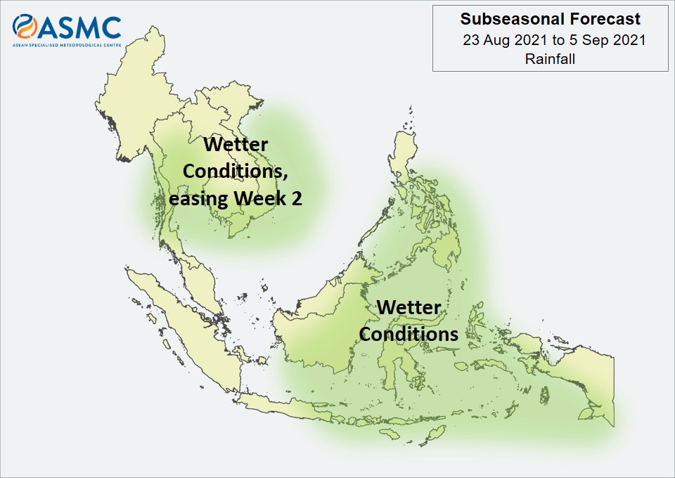
Wetter conditions are expected in Week 1 (23 – 29 August) over most of the central and eastern Maritime Continent. These wetter conditions are expected to persist in Week 2 (30 August – 5 September), extending to Java and possibly southern Sumatra.

Elsewhere, wetter conditions are expected in Week 1 (23 – 29 August) over the southern part of Mainland Southeast Asia as well as the coastal parts of Viet Nam. These wetter conditions are generally expected to ease in Week 2 (30 August – 5 September), apart from a small increase in probability that they continue for the coastal regions.

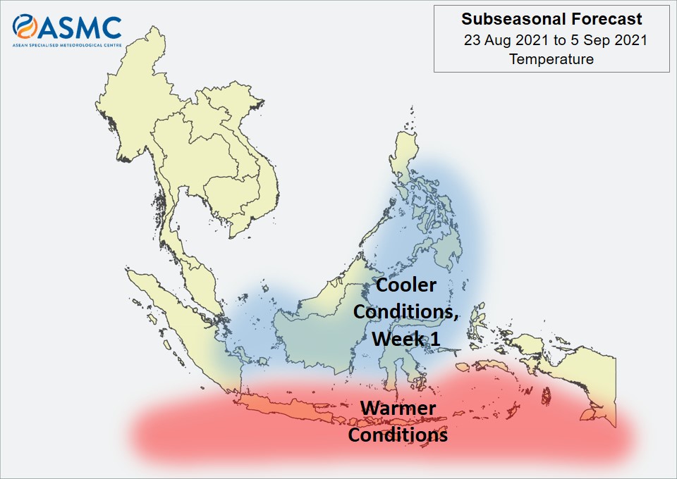
Warmer temperatures are expected over the southern Maritime Continent in the next fortnight (23 August – 5 September). Cooler temperatures than usual are expected in Week 1 (23 – 29 August) over parts of the equatorial region as well as parts of the Philippines.

An MJO signal was present over the Indian Ocean (Phase 2) in the middle of August. Most models predict the MJO to weaken and become indiscernible based on the RMM Index in the forecast period.
 
The outlook is assessed for the region in general, where conditions are relative to the average conditions for the corresponding time of year. For specific updates on the national scale, the relevant ASEAN National Meteorological and Hydrological Services should be consulted.

August 18, 2021

Webinar on Hotspot and Haze Assessment (H2A) for the southern ASEAN region (1 – 2 July 2021)

Webinar on Hotspot and Haze Assessment (H2A) for the southern ASEAN region (1 – 2 July 2021)

The ASEAN Specialised Meteorological Centre (ASMC) conducted a Webinar on Hotspot and Haze Assessment (H2A) for the southern ASEAN region over two days from 1 to 2 July 2021. The Webinar was conducted under the ASMC’s 5-year Regional Capability Programme which was launched in 2018 to address the priority training needs of the ASEAN region.
The Webinar welcomed 14 regional participants from the environmental policy, air quality monitoring, fire and rescue services and meteorological sectors. The participants shared actively on their country’s monitoring of fire and haze and were keen to learn from ASMC on the use of satellites for hotspot and haze monitoring and detection. The workshop included lectures on dispersion modelling, seasonal and sub-seasonal prediction products, as well as latest information of new satellites and satellite products for hotspots and haze monitoring available on the ASMC website.

Participants with the ASMC meteorologists and research scientists in a group photo.

Ms Razatul Aini Binti Razlan, from the Department of Environment in Malaysia shared that the lectures were relevant and useful, and she would recommend the programme to her country officers. She hoped similar training workshops in the future would be opened to more participants and emphasise on the interpretation of satellite images.

Screen shots of the lectures conducted by ASMC meteorologists and research scientists.

In the wake of restrictions brought about by the COVID-19 pandemic, all of ASMC’s workshops under the 5-year Regional Capability Programme including workshops on Numerical Weather Prediction (NWP), ASEAN Climate Data, Analysis and Projections (ARCDAP) and the ASEAN Climate Outlook Forum (ASEANCOF) have moved to an online platform to continuously engage and raise regional capabilities in weather forecasting, subseasonal-to-seasonal prediction, climate change projections and haze monitoring.

August 17, 2021

Review of Regional Haze Situation for July 2021

Review of Regional Haze Situation for July 2021

1.1 In July 2021, Southwest Monsoon conditions prevailed over the ASEAN region with the low-level winds blowing from the southeast or southwest on most days (Figure 1). During the first fortnight of the month, wet weather was observed over most parts of the ASEAN region as the monsoon rain band remained near the equatorial southern ASEAN region. Towards the second fortnight of the month, the monsoon rain band shifted further north of the Equator. This led to dry conditions over parts of the southern ASEAN region and indicated the start of the region’s traditional dry season.

1.2 As it is the traditional wet season for the northern ASEAN region, showers were observed over the region on most days during the month. The average daily rainfall was highest over the northern parts of the Philippines during the month (Figure 1) due to the influence of Typhoon Cempaka that formed in the South China Sea, west of the Philippines in the second fortnight of the month.

Figure 1: Average Daily Rainfall and Mean Wind for July 2021. (Source: JAXA GsMaP and GFS respectively)


1.3 For the July review period, the hotspot counts over the ASEAN region for 2021 were mostly lower or comparable to those in previous years (Figures 2 and 3), except for Sabah and Sarawak as well as the Philippines where slightly higher hotspot counts were detected.

Figure 2: Hotspot counts for the southern ASEAN region for the month of July (2017 – 2021). [Note: The hotspot counts from 2019 onwards are based on the NOAA-20 satellite, while those from 2017 – 2018 are based on the Suomi-NPP satellite.]


Figure 3: Hotspot counts for the northern ASEAN region for the month of July (2017 – 2021). [Note: The hotspot counts from 2019 onwards are based on the NOAA-20 satellite, while those from 2017 – 2018 are based on the Suomi-NPP satellite.]


1.4 Isolated to scattered hotspots were detected in most parts of the southern ASEAN region (Figure 4) in July 2021. Under drier conditions in the second fortnight of the month, the hotspot situation over central and southern parts of Sumatra as well as the northern and western parts of the Borneo Island worsened. Hotspot clusters with intense fires were detected in Riau, Jambi, South Sumatra, Lampung, Bangka-Belitung and Sarawak as well as in West and North Kalimantan (Figure 4 and Figure 5). Localised smoke plumes were observed to emanate from clusters of hotspots detected in Sumatra and Borneo Island on some days.

1.5 In the northern ASEAN region, isolated hotspots were detected mostly in Viet Nam and Cambodia during periods of drier conditions, but no smoke plumes were observed (Figure 4).

Figure 4: Distribution of hotspots detected in July 2021 based on NOAA-20 satellite surveillance.


Figure 5: Maximum fire intensity in July 2021 based on NOAA-20 satellite surveillance.


August 13, 2021

Review of Regional Weather for July 2021

Review of Regional Weather for July 2021

1. Overview

1.1 During July 2021, there was a mix of below- to above-average rainfall over the ASEAN region (Figure 1). The largest positive anomalies (wetter conditions) were over the coastal parts of southern Myanmar, southern Cambodia, northwestern Philippines, as well as the Maluku Islands for both satellite-derived rainfall estimates datasets (GSMaP-NRT and CMORPH-Blended). The two datasets were also in agreement that the largest negative anomalies (drier conditions) were over the central Philippines. However, there were some discrepancies over the western and central Maritime Continent, where CMORPH-Blended recorded drier conditions than GSMaP-NRT.

1.2 The observed rainfall anomaly pattern (i.e. mix of below- to above-average rainfall) is broadly consistent with the predictions from the subseasonal weather outlooks for July 2021 (28 June – 11 July and 12 – 25 July). The only portion of the ASEAN region with a consistent outlook for July were the wetter conditions in the southeastern Maritime Continent, which agrees with the observed anomaly pattern.

era5_rainfall_anomalies
cmorph_bld_rainfall_anomalies
Figure 1: Rainfall anomalies for the month of July 2021 based on GSMaP-NRT data (left) and CMORPH-Blended data (right). The climatological reference period is 2001-2020. Green colour denotes above-average rainfall (wetter), while orange denotes below-average rainfall (drier).


1.3 Most of the ASEAN region experienced above-average temperatures during July 2021 (Figure 2). The warmest anomalies (above-average temperature) were recorded over Lao PDR and the southern Maritime Continent, followed by central and northern Myanmar, Viet Nam, and central and southern parts of the Philippines. Elsewhere, near- to above-average temperature were recorded.

era5_temperature_anomalies


Figure 2: Temperature anomalies for the month of July 2021 based on ERA-5 reanalysis. The climatological reference period is 2001-2020. Red colour denotes above-average temperature (warmer), while blue denotes below-average temperature (colder).


2. Climate Drivers

2.1 At the start of July 2021, a Madden-Julian Oscillation (MJO) signal was present in the Indian Ocean (Phases 2 and 3, Figure 3). In the second week of July the signal propagated eastwards over the Maritime Continent (Phases 4 and 5). The signal then weakened slightly as it moved over the Western Pacific (Phases 6 and 7), although it strengthened again entering the Western Hemisphere (Phase 8) at the end of July. The mix of below- to above-average rainfall for the ASEAN region is indicative of the near complete circumnavigation of the MJO signal: Phases 3 to 4 tend to bring wetter conditions to much of the region, while Phases 7 to 8 tend to bring drier conditions, and Phase 2 and Phase 5 bring a mix of drier and wetter conditions at this time of the year.

mjo_phase_diagram


Figure 3: The MJO phase diagram. The diagram illustrates the movement of the MJO through different phases, which correspond to different locations along the equator (denoted in the text with the first day of the month in blue and the last day of the month in red). The distance of the index from the centre of the diagram is related to the strength of the MJO. Values within the grey circle are considered weak or indiscernible (data from the Bureau of Meteorology, Australia).


2.2 The equatorial Pacific Ocean is currently in an ‘ENSO-neutral’ state. A negative Indian Ocean Dipole (IOD) has developed in the Indian Ocean, with warmer sea surface temperatures southwest of Java during July. At the seasonal timescale, negative IOD events tend to bring wetter conditions to the southern Maritime Continent.

August 6, 2021

Subseasonal Weather Outlook (9 – 22 August 2021)

Subseasonal Weather Outlook (9 – 22 August 2021)

Issued 6 August 2021
First forecast week: 9 August – 15 August
Second forecast week: 16 August – 22 August

figure1

Figure 1: Rainfall Outlook

figure2

Figure 2: Temperature Outlook


Wetter conditions are expected in Week 1 (9 – 15 August) over most of the southern ASEAN region. These wetter conditions are expected to persist in Week 2 (16 – 22 August) except for parts of the western Maritime Continent.

Drier conditions are expected in Week 1 (9 – 15 August) over western parts of Mainland Southeast Asia.

Warmer temperatures than usual are expected in Week 1 (9 – 15 August) over most of Mainland Southeast Asia, easing in Week 2 (16 – 22 August). Elsewhere, warmer temperatures are also expected over southern parts of the Maritime Continent in the next fortnight (9 – 22 August).

Cooler temperatures than usual are expected in Week 2 (16 – 22 August) over parts of the central Maritime Continent.

An MJO signal was present over the Western Hemisphere and Africa (Phase 8) at the beginning of August, although the signal was no longer discernible based on the RMM Index by the start of the forecast period. Some models predict the MJO to reemerge in Week 1 (either in Phase 1 or Phase 2) and continue propagating eastwards over the Indian Ocean (Phases 2 and 3).
 
The outlook is assessed for the region in general, where conditions are relative to the average conditions for the corresponding time of year. For specific updates on the national scale, the relevant ASEAN National Meteorological and Hydrological Services should be consulted.