Monthly Archives: November 2021

November 26, 2021

Subseasonal Weather Outlook (29 November – 12 December 2021)

Subseasonal Weather Outlook (29 November – 12 December 2021)

Issued 26 November 2021
First forecast week: 29 November – 5 December
Second forecast week: 6 November – 12 December

figure1

Figure 1: Rainfall Outlook

figure2

Figure 2: Temperature Outlook


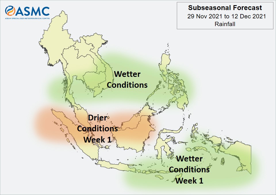
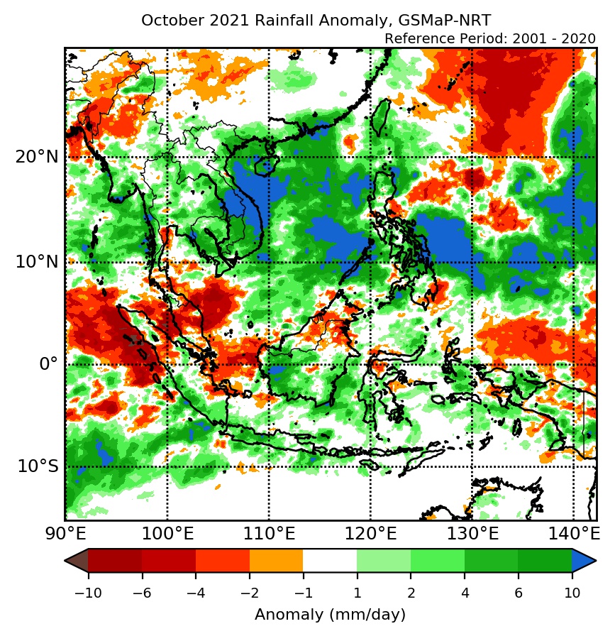
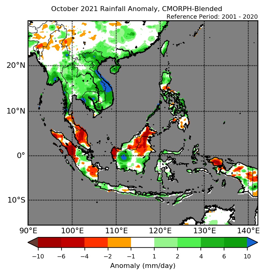
Wetter conditions are expected over southern Mainland Southeast Asia, parts of the Philippines, and the southeastern Maritime Continent in Week 1 (29 November – 5 December). These wetter conditions are likely to persist over coastal parts of Viet Nam and the Philippines in Week 2 (6 – 12 December).

Drier conditions are expected over the western and central equatorial region in Week 1 (29 November – 5 December).

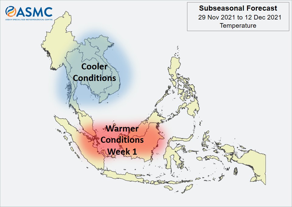
For temperature, cooler than usual temperature is expected over much of Mainland Southeast Asia in the next fortnight (29 November – 12 December). Warmer than usual temperature is expected over the western and central equatorial region in Week 1 (29 November – 5 December), in line with the drier conditions predicted.

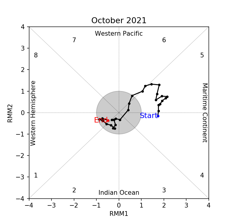
No coherent Madden-Julian Oscillation (MJO) signal was present towards the end of November. Some models predict an MJO signal to propagate eastward through the Maritime Continent (Phases 4 and 5) and the Western Pacific (Phases 6 and 7) in the forecast period.

The outlook is assessed for the region in general, where conditions are relative to the average conditions for the corresponding time of year. For specific updates on the national scale, the relevant ASEAN National Meteorological and Hydrological Services should be consulted.

November 16, 2021

Review of Regional Weather for October 2021

Review of Regional Weather for October 2021

1. Overview

1.1 During October 2021, above-average rainfall was recorded over much of the northern ASEAN region, while a mix of below- to above-average rainfall was recorded over the southern ASEAN region (Figure 1). For the northern ASEAN region, above-average rainfall was recorded apart from over central and northern Myanmar and parts of the Philippines. The largest positive anomalies (wetter conditions) were recorded over eastern Mainland Southeast Asia for both satellite-derived rainfall estimates datasets (GSMaP-NRT and CMORPH-Blended), which was associated with Severe Tropical Storm Kompasu. A second tropical storm, Tropical Storm Lionrock, crossed the central Philippines at the start of October, contributing to the large positive anomalies in the ocean region around the Philippines (GSMaP-NRT). For the southern ASEAN region, negative anomalies (drier conditions) were recorded over western parts as well as northern Borneo, although the negative anomalies were larger based on CMORPH-Blended data compared to GSMaP-NRT. Elsewhere in the southern ASEAN region, rainfall tended to be near-to above-average during October 2021.

1.2 The observed rainfall anomaly pattern of above-average rainfall for much of the northern ASEAN region and a mix of below- to above-average rainfall for the southern ASEAN region is broadly consistent with the predictions from the subseasonal weather outlooks for October 2021 (4 – 17 October and 18 – 31 October).

era5_rainfall_anomalies
cmorph_bld_rainfall_anomalies
Figure 1: Rainfall anomalies for the month of October 2021 based on GSMaP-NRT data (left) and CMORPH-Blended data (right). The climatological reference period is 2001-2020. Green colour denotes above-average rainfall (wetter), while orange denotes below-average rainfall (drier).


1.3 Most of the ASEAN region experienced near to above-average temperatures during October 2021 (Figure 2). The exception was over eastern parts of Mainland Southeast Asia, which experienced below- to near-average temperatures. The largest positive anomalies (warmer temperatures) were over northern Myanmar and the western Maritime Continent where negative rainfall anomalies (drier conditions) were also recorded.

era5_temperature_anomalies


Figure 2: Temperature anomalies for the month of October 2021 based on ERA-5 reanalysis. The climatological reference period is 2001-2020. Red colour denotes above-average temperature (warmer), while blue denotes below-average temperature (colder).


2. Climate Drivers

2.1 The Madden-Julian Oscillation (MJO, Figure 3) signal was present over the Maritime Continent at the start of October 2021 (Phases 4 and 5). However, this signal weakened rapidly as it approached the Western Pacific (Phase 6) likely influenced by the background La Niña conditions. For the rest of October, there was no discernible MJO signal, based on the MJO phase diagram below. Phases 4 and 5 tend to bring wetter conditions to parts of the ASEAN region around 10°N, while Phase 5 tends to bring drier conditions to the western Maritime Continent.

mjo_phase_diagram


Figure 3: The MJO phase diagram. The diagram illustrates the movement of the MJO through different phases, which correspond to different locations along the equator (denoted in the text with the first day of the month in blue and the last day of the month in red). The distance of the index from the centre of the diagram is related to the strength of the MJO. Values within the grey circle are considered weak or indiscernible (data from the Bureau of Meteorology, Australia).


2.2 By the end of October 2021, La Niña conditions were present in the tropical Pacific. Sea surface temperatures in the Nino3.4 region (used to monitor ENSO) continued to cool, with some signs of La Niña conditions in the atmosphere. A weak negative Indian Ocean Dipole (IOD) was present and at the seasonal timescale, negative IOD events tend to bring wetter conditions to the southern Maritime Continent.

November 15, 2021

Review of Regional Haze Situation for October 2021

Review of Regional Haze Situation for October 2021

1.1 Southwest Monsoon conditions transitioned to the inter-monsoon in mid-October 2021 as the winds over most parts of the ASEAN region turned light and variable (Figure 1). In the first half of October 2021, Tropical Storm Lionrock and Typhoon Kompasu contributed to increased rainfall over the northern parts of the Philippines and central parts of Viet Nam. In particular, Typhoon Kompasu caused significant damage and casualties in the Philippines due to landslides and flash floods. The southern ASEAN region experienced continued shower activities during the review period and Alert Level 0 was issued for the region on 18 October 2021, signaling the end of its traditional dry season. Average daily rainfall was relatively higher in western Kalimantan and northern Sumatra, while persistent dry conditions were observed over eastern Java and the Lesser Sunda Islands.

Figure 1: Average Daily Rainfall and Mean Wind for October 2021. (Source: JAXA GsMaP and GFS respectively)


1.2 In October 2021, overall hotspot activity in the ASEAN region was subdued, contributed by wet weather conditions. While most of the hotspots in the southern ASEAN region were detected in Kalimantan, the number of hotspots for the southern ASEAN region were lower or comparable to previous years’ counts (Figure 2), except for Sabah and Sarawak where it was slightly higher. For the northern ASEAN region, most of the hotspots were detected in Viet Nam. The number of hotspots detected in the northern ASEAN region were also lower or comparable to previous years (Figure 3).

Figure 2: Hotspot counts for the southern ASEAN region for the month of October (2017 – 2021). [Note: The hotspot counts from 2019 onwards are based on the NOAA-20 satellite, while those from 2017 – 2018 are based on the Suomi-NPP satellite.]


Figure 3: Hotspot counts for the northern ASEAN region for the month of October (2017 – 2021). [Note: The hotspot counts from 2019 onwards are based on the NOAA-20 satellite, while those from 2017 – 2018 are based on the Suomi-NPP satellite.]


1.3 For the October 2021 review period, isolated to scattered hotspots were detected mainly in central Viet Nam, Borneo, and Sumatra (Figure 4 and 5). On a few days, short-lived localized smoke haze was observed to emanate from clusters of hotspots in central Kalimantan. There was no transboundary smoke haze observed over the ASEAN region during the review period.

Figure 4: Distribution of hotspots detected in October 2021 based on NOAA-20 satellite surveillance.


Figure 5: Maximum fire intensity in October 2021 based on NOAA-20 satellite surveillance.


November 12, 2021

Subseasonal Weather Outlook (15 – 28 November 2021)

Subseasonal Weather Outlook (15 – 28 November 2021)

Issued 12 November 2021
First forecast week: 15 November – 21 November
Second forecast week: 22 November – 28 November

figure1

Figure 1: Rainfall Outlook

figure2

Figure 2: Temperature Outlook


Wetter conditions are expected over much of western and southern Mainland Southeast Asia in Week 1 (15 – 21 November). These wetter conditions are likely to persist over western Mainland Southeast Asia, but likely to ease over southern Mainland Southeast Asia, in Week 2 (22 – 28 November).

For the Maritime Continent, wetter conditions are expected over the southern parts in the next fortnight (15 – 28 November). Elsewhere, drier conditions are expected over the western and central equatorial region in Week 1 (15 – 21 November).

Warmer than usual temperature is expected over the western and central equatorial region in Week 1 (15 – 21 November), in line with the drier conditions predicted.

No clear MJO signal was present at the start of November. Most models predict the MJO to remain indiscernible based on the RMM Index during the forecast period.

The outlook is assessed for the region in general, where conditions are relative to the average conditions for the corresponding time of year. For specific updates on the national scale, the relevant ASEAN National Meteorological and Hydrological Services should be consulted.