Monthly Archives: October 2024

October 24, 2024

Subseasonal Weather Outlook (28 October – 10 November 2024)

Subseasonal Weather Outlook (28 October – 10 November 2024)

Issued: 24 October 2024
First forecast week: 28 October – 3 November 2024
Second forecast week: 4 November – 10 November 2024

figure1

Figure 1: Rainfall Outlook

figure2

Figure 2: Temperature Outlook

Wetter conditions are predicted over the southern Maritime Continent in the next fortnight (28 October – 10 November).

Drier conditions are predicted over southeastern Mainland Southeast Asia and parts of the northern half of the Maritime Continent in Week 1 (28 October – 3 November).

Warmer than usual temperature is predicted over the Maritime Continent, apart from the southern region, in the next fortnight (28 October – 10 November). Cooler than usual temperature is predicted over much of eastern Mainland Southeast Asia in Week 1 (28 October – 3 November).

A Madden-Julian Oscillation (MJO) signal was present over the Maritime Continent (Phases 4 and 5) in the middle of October. This MJO signal is predicted to propagate through the Western Pacific (Phases 6 and 7) in Week 1. Most models predict the MJO signal to reach the Western Hemisphere and Africa (Phases 8 and 1) by the start of Week 2 before weakening.

The outlook is assessed for the region in general, where conditions are relative to the average conditions for the corresponding time of year. For specific updates on the national scale, the relevant ASEAN National Meteorological and Hydrological Services should be consulted.

October 15, 2024

Review of Regional Weather for September 2024

Review of Regional Weather for September 2024


1. Overview

1.1 During September 2024, the Maritime Continent experienced a mix of below- and above-average rainfall, with much of Mainland Southeast Asia experiencing above-average rainfall . For the Maritime Continent, much of the eastern equatorial region experienced below-average rainfall while the northern Philippines and the southern Maritime Continent experienced above-average rainfall (Figure 1). Above-average rainfall was recorded over much of northern and eastern Mainland Southeast Asia, although there was disagreement over the southern parts of Mainland Southeast Asia with GSMaP-NRT (Figure 1, left) recording near- to above-average rainfall, while CMORPH-Blended (Figure 1, right) recorded a mix of below- and above-average rainfall. The largest negative (drier) anomalies were recorded over Papua, southern Philippines and northeast Borneo in GSMap-NRT (Figure 1, left) and CMORPH-Blended (Figure 1, right). The larger positive (wetter) anomalies were recorded over northern Viet Nam and northern Philippines (in both GSMap-NRT and CMORPH-Blended), partly associated with Typhoon Yagi in early September.

1.2 The observed rainfall anomaly pattern of above-average rainfall over much of the northern ASEAN region and a mix of below- and above-average rainfall is consistent with the predictions from the subseasonal weather outlooks for September 2024 (2 – 15 September 2024 and 16 – 29 September 2024).

era5_rainfall_anomalies
cmorph_bld_rainfall_anomalies
Figure 1: Rainfall anomalies for September 2024 based on GSMaP-NRT data (left) and CMORPH-Blended data (right). The climatological reference period is 2001-2023. Green colour denotes above-average rainfall (wetter), while orange denotes below-average rainfall (drier).


1.3 Above-average temperatures were recorded over the much of ASEAN region in September 2024 (Figure 2). The warmest anomalies (more than 1°C above average) were recorded over northern Myanmar, southern Sumatra, Sulawesi and parts of Borneo, based on ERA-5 reanalysis.

era5_temperature_anomalies
Figure 2: Temperature anomalies for September 2024 based on ERA-5 reanalysis. The climatological reference period is 2001-2023. Red colour denotes above-average temperature (warmer), while blue denotes below-average temperature (colder).


2. Climate Drivers

2.1 The Madden-Julian Oscillation (MJO) was active during much of September 2024, based on the RMM index (Figure 3). For much of the first half of September, an MJO signal propagated eastwards through the Maritime Continent (Phases 4 and 5). In the third week of the month, the signal was active over the Western Pacific (Phases 6 and 7), before propagating eastwards through the Western Hemisphere (Phases 8 and 1) during the last week of the month. For September, Phases 4 to 5 tend to bring wetter conditions to parts of southern Mainland Southeast Asia and the Philippines (in line with Figure 1), while Phases 8 and 1 tend to bring drier conditions to these regions.

mjo_phase_diagram


Figure 3: The MJO phase diagram. The diagram illustrates the movement of the MJO through different phases, which correspond to different locations along the equator (denoted in the text with the first day of the month in blue and the last day of the month in red). The distance of the index from the centre of the diagram is related to the strength of the MJO. Values within the grey circle are considered weak or indiscernible (data from the Bureau of Meteorology, Australia).


2.2 The tropical Pacific was in an ENSO neutral state during September.


October 14, 2024

Alert20241014 – End of Dry Season for the Southern ASEAN Region

End of Dry Season for the Southern ASEAN Region

Widespread showers in recent days had alleviated the overall hotspot and smoke haze situation over the southern ASEAN region. Based on surveillance by the NOAA-20 satellite, a total of 18 and 4 hotspots were detected in Kalimantan on 12 and 13 October 2024 respectively, and a total of 1 and 0 hotspots were detected in Sumatra on 12 and 13 October 2024 respectively.

With wet weather expected to continue over the southern ASEAN region in the coming months, the overall hotspot and smoke haze situation is likely to remain subdued. However, isolated hotspots and localised smoke plumes may still occur in fire-prone areas during brief periods of relatively drier weather.

October 10, 2024

Subseasonal Weather Outlook (14 – 27 October 2024)

Subseasonal Weather Outlook (14 – 27 October 2024)

Issued: 10 October 2024
First forecast week: 14 – 20 October 2024
Second forecast week: 21 – 27 October 2024

figure1

Figure 1: Rainfall Outlook

figure2

Figure 2: Temperature Outlook

Wetter conditions are predicted over southwestern and central parts of Mainland Southeast Asia and much of the southern ASEAN region in Week 1 (14 – 20 October). Wetter conditions are also predicted over the northeastern Maritime Continent in Week 2 (21 – 27 October).

Drier conditions are predicted over most of the southern ASEAN region in Week 2 (21 – 27 October).

Warmer than usual temperature is predicted over much of northern Mainland Southeast Asia in Week 1 (14 – 20 October). Warmer than usual temperature is also predicted over most of the southern ASEAN region in Week 2 (21 – 27 October).

A Madden-Julian Oscillation (MJO) signal was present over the Indian Ocean (Phases 2 and 3) at the start of October. An MJO signal is predicted to propagate through the Maritime Continent (Phases 4 and 5) in Week 1. Most models predict this MJO signal to reach the Western Pacific (Phases 6 and 7) in Week 2, although some models predict the signal to reach Phase 6 by the end of Week 1.

The outlook is assessed for the region in general, where conditions are relative to the average conditions for the corresponding time of year. For specific updates on the national scale, the relevant ASEAN National Meteorological and Hydrological Services should be consulted.

October 9, 2024

ASMC-WMO Regional Forum 2024, 4 – 6 September 2024

ASMC-WMO Regional Forum 2024 (4 – 6 September 2024)

ASMC and WMO jointly organised the inaugural ASMC – WMO Regional Forum in Singapore, from 4 to 6 September 2024.  Titled “Towards a Weather-Ready and Climate-Resilient ASEAN”, the Forum brought together global, regional and national leaders and partners from across the climate services value chain to focus on how climate services, including high-resolution regional climate projections and early warning systems, can better support climate change adaptation and disaster risk reduction in Southeast Asia. The Forum also discussed how effective and inclusive early warning systems can mitigate the impact of extreme weather and climate events, especially in light of the Early Warnings for All (EW4All) initiative. Key highlights of the Forum included:

  • Deep dive into findings relevant to Southeast Asia from the 2023 WMO State of the Climate Reports for the South-West Pacific and Asia, with keynote address by Prof. Celeste Saulo, Secretary-General of the WMO and panel discussion on supporting ASEAN member states in translating climate information into actions.
  • Keynote presentations on climate change projections for Southeast Asia and the United Nations Early Warnings for All (EW4All) initiative
  • Technical Forums on Adapting to Climate Change in Southeast Asia, and Early Warning Systems as an Adaptive Measure: Panellists discussed about the current challenge and disaster riskscape in the Southeast Asia, the opportunity and on supports for NMHSs and ASEAN Member States in achieving EW4All.

The recordings on the presentations, panel discussions, the summaries from the World Café sessions, interactive group exercises and the regional forum can be accessed via link

October 8, 2024

Review of Regional Haze Situation for September 2024

Review of Regional Haze Situation for September 2024

1.1 Southwest Monsoon conditions persisted in September 2024 as the prevailing winds blew mainly from the southeast over areas south of the Equator and turned to blow from the southwest or west over areas north of the Equator (Figure 1).

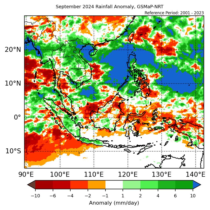
1.2 Rainy conditions prevailed over most parts of the ASEAN region in September 2024, except for parts of Kalimantan, Sumatra, Java and the Lesser Sunda Islands which saw occasional dry weather . The month was marked by the occurrences of multiple tropical cyclones/typhoon, with Typhoon Yagi being the most notable one, which formed during the first week of the review period, and later Tropical Storm Soulik , which formed during the middle of the month. Heavy rain and strong winds brought by the storms affected large parts of northern Philippines and the northern parts of Viet Nam as they made landfall over both countries, resulting in significant damage to infrastructures and loss of life (Figure 1).

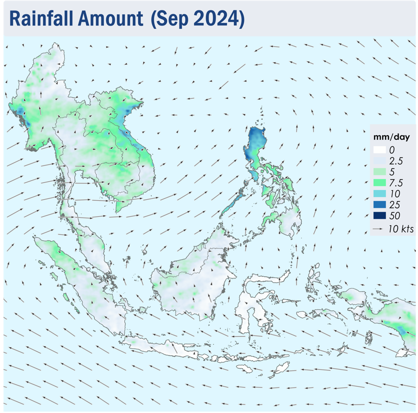
Figure 1: Average Daily Rainfall and Mean Winds for September 2024. (Source: JAXA GsMaP and GFS, respectively)


1.3 In September 2024, overall hotspot activity in the southern ASEAN region were generally comparable to previous years. Over Kalimantan, the hotspot counts in 2024 were as high as in 2023 (Figure 2) . For the northern ASEAN region, hotspot counts were lower or comparable to the same period in previous years (Figure 3).


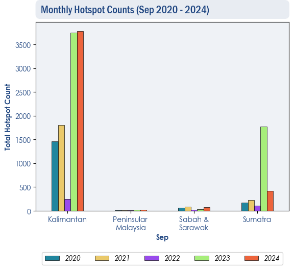
Figure 2: Hotspot counts for the southern ASEAN region for September (2020-2024) based on NOAA-20 satellite surveillance.


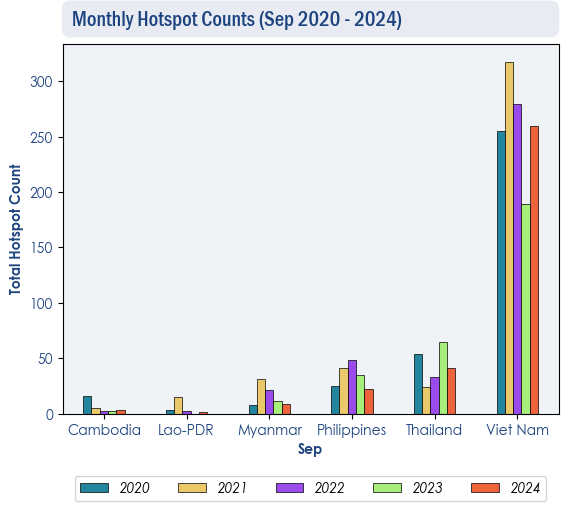
Figure 3: Hotspot counts for the northern ASEAN region for September (2020-2024) based on NOAA-20 satellite surveillance.


1.4 Isolated to scattered hotspots were detected in Sumatra, Kalimantan, Java and the Lesser Sunda Islands on multiple days during the review period, with more intense and persistent hotspots located mostly in Kalimantan (Figure 4 and 5). Slight to moderate smoke haze was observed over parts of West Kalimantan, while localised smoke plumes were seen emanating from hotspots in other parts of Kalimantan, as well as from hotspots in the central and southern parts of Sumatra (Figure 6, 7 and 8). Smoke haze from West Kalimantan was also observed to drift into western Sarawak on some days during the review period. While the hotspot activity in the Mekong sub-region was suppressed, isolated hotspots were detected mostly in the central parts of Viet Nam (Figure 4 and 5).


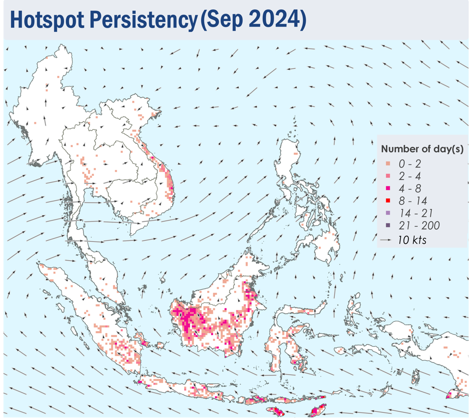
Figure 4: Distribution of hotspots detected in September 2024 based on NOAA-20 satellite surveillance.


Figure 5: Maximum fire intensity in September 2024 based on NOAA-20 satellite surveillance.


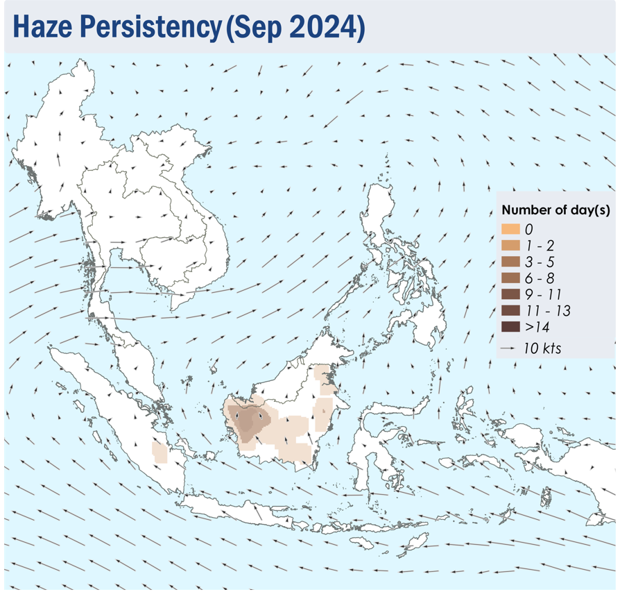
Figure 6: Number of days with moderate to dense smoke haze observed in Septmeber 2024 based on satellite imagery, ground observations, and air quality reports.


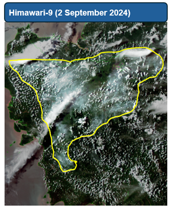
Figure 7: Slight to moderate smoke haze were observed over clusters of hotspots in the western parts of Kalimantan on 2 September 2024. (Source: Himawari-9 satellite surveillance)


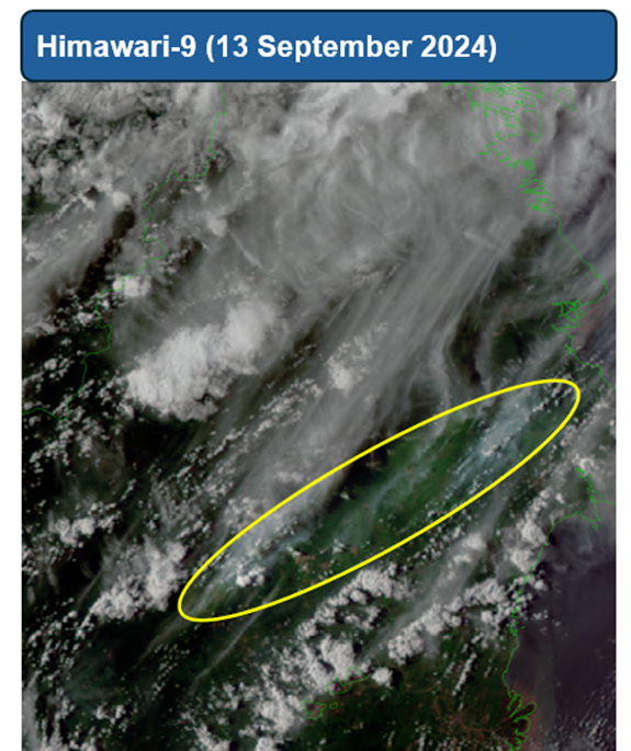
Figure 8: Slight to moderate localised smoke plumes were observed over hotspots in the eastern parts of Kalimantan on 13 September 2024. (Source: Himawari-9 satellite surveillance)