Monthly Archives: December 2024

December 18, 2024

Subseasonal Weather Outlook (23 December 2024 – 5 January 2025)

Subseasonal Weather Outlook (23 December 2024 – 5 January 2025)

Issued: 18 December 2024
First forecast week: 23 – 29 December 2024
Second forecast week: 30 December 2024 – 5 January 2025

figure1

Figure 1: Rainfall Outlook

figure2

Figure 2: Temperature Outlook

In Week 1 (23 – 29 December), drier conditions are predicted over parts of the western Maritime Continent, while wetter conditions are predicted over southeastern Mainland Southeast Asia and the northeastern Maritime Continent. These wetter conditions are likely to extend into Week 2 (30 December – 5 January).

Warmer than usual temperature is predicted over the equatorial region in Week 1 (23 – 29 December). Cooler than usual temperature is predicted over central and eastern Mainland Southeast Asia in the next fortnight (23 December – 5 January).

A Madden-Julian Oscillation (MJO) signal was present over the Maritime Continent (Phase 5) towards the middle of December. Most models predict this signal to continue propagating through the Western Pacific (Phases 6 and 7) towards the Western Hemisphere (Phase 8) during the forecast period. However, some models predict a weakening of the signal while it propagates through the Western Pacific (Phases 6 and 7), becoming temporarily indiscernible.

The outlook is assessed for the region in general, where conditions are relative to the average conditions for the corresponding time of year. For specific updates on the national scale, the relevant ASEAN National Meteorological and Hydrological Services should be consulted.

December 16, 2024

Review of Regional Weather for November 2024

Review of Regional Weather for November 2024


1. Overview

1.1 During November 2024, the ASEAN region experienced a mix of below- and above-average rainfall. For the Maritime Continent, much of the western half experienced above-average rainfall while the eastern half experienced a mix of below- to above-average rainfall (Figure 1). For Mainland Southeast Asia, above-average rainfall was recorded over parts of central and northern Myanmar and southern Thailand, with below-average rainfall over parts of eastern Mainland Southeast Asia and near-average rainfall elsewhere, although there is disagreement over central Viet Nam with GSMaP-NRT (Figure 1, left) recording below-average rainfall, while CMORPH-Blended (Figure 1, right) recorded above-average rainfall. The largest positive (wetter) anomalies were recorded over the Malay Peninsula, while the largest negative (drier) anomalies were recorded over southeastern Viet Nam and central Philippines in both GSMaP-NRT and CMORPH-Blended.

1.2 The observed rainfall anomaly pattern of a mix of below- and above-average rainfall in the ASEAN region, with above-average rainfall over the western Maritime Continent is consistent with the predictions from the subseasonal weather outlooks for November 2024 (28 October – 10 November 2024, 11 – 24 November 2024), and 25 November – 8 December 2024).

era5_rainfall_anomalies
cmorph_bld_rainfall_anomalies
Figure 1: Rainfall anomalies for November 2024 based on GSMaP-NRT data (left) and CMORPH-Blended data (right). The climatological reference period is 2001-2023. Green colour denotes above-average rainfall (wetter), while orange denotes below-average rainfall (drier).


1.3 Above-average temperatures were recorded over much of the ASEAN region in November 2024 (Figure 2), with below-average temperatures recorded over a few scattered points of Mainland Southeast Asia. The warmest anomalies (more than 1°C above average) were recorded mainly over northern Viet Nam based on ERA-5 reanalysis.

era5_temperature_anomalies
Figure 2: Temperature anomalies for November 2024 based on ERA-5 reanalysis. The climatological reference period is 2001-2023. Red colour denotes above-average temperature (warmer), while blue denotes below-average temperature (colder).


2. Climate Drivers

2.1 The Madden-Julian Oscillation (MJO) was active from the beginning of the first week of November 2024, based on the RMM index (Figure 3). An MJO signal was present over the Western Hemisphere (Phases 8 and 1) during the first week of November, which weakened for a short period towards the end of week 2 as it propagated eastwards. During the third week, the MJO signal emerged and remained active over the Indian Ocean (Phases 2 and 3), and propagated eastwards to the Maritime Continent (Phase 4) during the last week of the month. Phases 8 and 1 typically bring drier conditions for much of Southeast Asia during this time of the year. For November, Phases 2 and 3 tend to bring wetter conditions to the western Maritime Continent (in line with Figure 1), and Phase 4 tends to bring wetter conditions to the Maritime Continent.

mjo_phase_diagram


Figure 3: The MJO phase diagram. The diagram illustrates the movement of the MJO through different phases, which correspond to different locations along the equator (denoted in the text with the first day of the month in blue and the last day of the month in red). The distance of the index from the centre of the diagram is related to the strength of the MJO. Values within the grey circle are considered weak or indiscernible (data from the Bureau of Meteorology, Australia).


2.2 In November, there were signs of La Niña-like conditions. The Nino3.4 index was approaching the La Niña threshold in October, and cool subsurface temperature anomalies in the central and eastern Pacific indicated La Niña-like conditions. However, westerly wind anomalies in the eastern tropical Pacific region during early November likely slowed the cooling process of the sea surface temperatures.


December 11, 2024

Review of Regional Haze Situation for November 2024

Review of Regional Haze Situation for November 2024

1.1 Northeast monsoon conditions emerged over the ASEAN region during November 2024 as the prevailing low-level winds over the Mekong sub-region, Peninsular Malaysia, Singapore and the Philippines blew from the northeast or east. Light and variable winds were still observed over areas south of the Equator and the northern parts of the Mekong sub-region (Figure 1).

1.2 Drier conditions were observed over most parts of the Mekong sub-region except for isolated showers recorded over Myanmar and the southern parts of Viet Nam. Showers were observed over most parts of the southern ASEAN region with intense rainfall recorded over southern Thailand and the eastern coastal regions of Peninsular Malaysia where floodings were reported (Figure 1). Intense rainfall was also recorded in the northern parts of the Philippines under the influence of multiple Typhoons and Super Typhoons which led to floodings and landslides in the area.

Figure 1: Average Daily Rainfall and Mean Winds for November 2024. (Source: JAXA GsMaP and GFS, respectively)


1.3 The overall hotspot counts in 2024 over the ASEAN region were lower than or comparable to previous years, except for Viet Nam where the hotspot count was slightly higher.


Figure 2: Hotspot counts for the southern ASEAN region for November (2020-2024) based on NOAA-20 satellite surveillance.


Figure 3: Hotspot counts for the northern ASEAN region for November (2020-2024) based on NOAA-20 satellite surveillance.


1.4 Persistent isolated hotspots were mostly detected in the central parts of Thailand and Myanmar, as well as the northern and central parts of Viet Nam.


Figure 4: Distribution of hotspots detected in November 2024 based on NOAA-20 satellite surveillance.


Figure 5: Maximum fire intensity in November 2024 based on NOAA-20 satellite surveillance.


December 9, 2024

23nd ASEAN COF (November 2024)

Twenty Third Session of the ASEAN Climate Outlook Forum (ASEANCOF-23)

image_gallery

26-29 November 2024, Online

Consensus Bulletin for December-January-February (DJF) 2024/2025 Season

The ASEAN Climate Outlook Forum (ASEANCOF) is an avenue to collaboratively develop consensus-based seasonal climate outlooks and related information on a regional scale. The forum’s outlook and its activities contribute significantly to one of the key roles of the ASEAN Specialised Meteorological Centre (ASMC), which is to conduct climate and seasonal prediction for the Association of Southeast Asian Nations (ASEAN) region through pooling the expertise of ASEAN National Meteorological and Hydrological Services (NMHSs). In 2021, the ASEANCOF Working Group was established with the goal to guide and support the long-term development of ASEANCOF, in particular with regard to the implementation of objective outlooks.

The Twenty-third session of ASEANCOF (ASEANCOF-23) was organised by the Department of Meteorology and Hydrology of Lao PDR, RIMES, the ASEANCOF Working Group, and WMO. Participants from the NMHSs of ASEAN Member States created a consensus forecast for the boreal winter monsoon 2024/2025 in the ASEAN region. The consensus for the December-January-February (DJF) 2024/2025 outlook was achieved through an online session, which included presentations from ASEAN NMHSs, questionnaires, and discussions regarding the current climate conditions and predictions for Southeast Asia. The theme of ASEANCOF-23 was Agriculture and Climate Services. On the last day of ASEANCOF-23, a sharing session was held which included updates from ASEANCOF-22 around the use of climate services for agriculture.

image_gallery


Conditions and Outlook

Recent analysis of sea surface temperature (SST) anomalies over the equatorial Pacific shows average to slightly below-average SSTs across the equatorial Pacific Ocean, and along with atmospheric indicators such as trade wind strength and cloudiness, indicate La Niña-like conditions. In the Indian Ocean, the positive Indian Ocean Dipole did not develop, and based on the recent analysis, the SST anomalies show signs of a negative Indian Ocean Dipole.
The international climate outlooks predict that a weak La Niña is likely to develop sometime in December 2024 and persist until February 2025. After DJF 2024/2025, most models predict La Niña conditions to transition back to ENSO neutral.
There is a chance that a short-lived negative Indian Ocean Dipole (IOD) may be present during December 2024 based on the model predictions. However, the IOD is predicted to be neutral during January – February 2025.
The onset of the Northeast Monsoon season has been or is expected to be near or later than average for much of the northern ASEAN region. The onset for much of the southern ASEAN region has been or is expected to be near average. The strength of the Northeast Monsoon is predicted to be near average over most of Southeast Asia.
During DJF 2024/2025, tropical cyclone frequency is predicted to be near average around the Philippine Sea, the Bay of Bengal, and South China Sea.
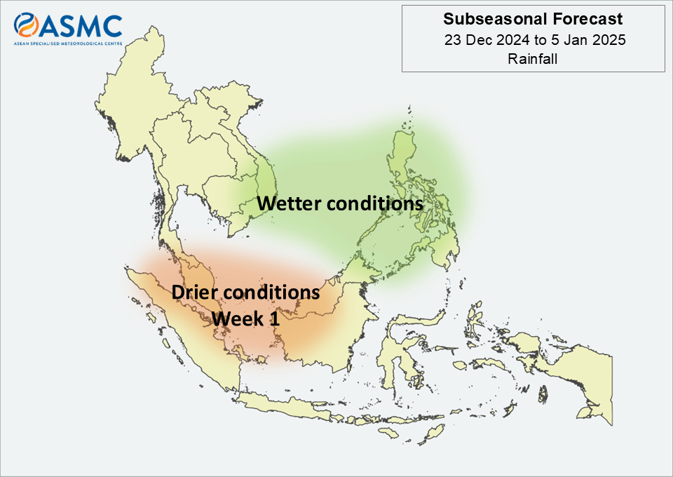
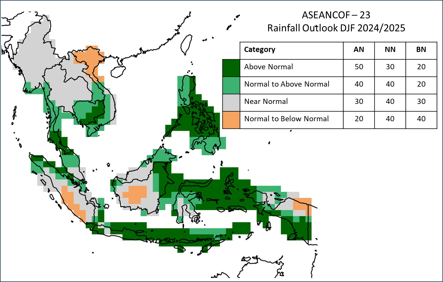
RAINFALL

For the upcoming boreal (Northern Hemisphere) winter season (DJF 2024/2025):
Over the Maritime Continent, near- to above-normal or above-normal rainfall is predicted for much of the region, including the Philippines, Brunei Darussalam, and Singapore. The exception is over parts of the equatorial region, where a mix of near-normal and normal- to below-normal rainfall is predicted.
Across Mainland Southeast Asia, near- to above-normal or above-normal rainfall is predicted for much of the southern part, including southern Myanmar, southern Thailand, Cambodia, southern Lao PDR, and southern Viet Nam. Below-normal rainfall is predicted for northern Viet Nam and elsewhere, near-normal rainfall is predicted.

Below-normal rainfall is predicted over the western part of Northern Philippines. Below- to near- normal rainfall is predicted over southern Lao PDR, the rest of Northern Philippines, and southernmost parts of Southeast Asia. Elsewhere, near-normal rainfall is predicted.1.
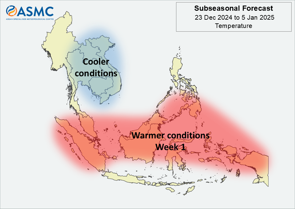
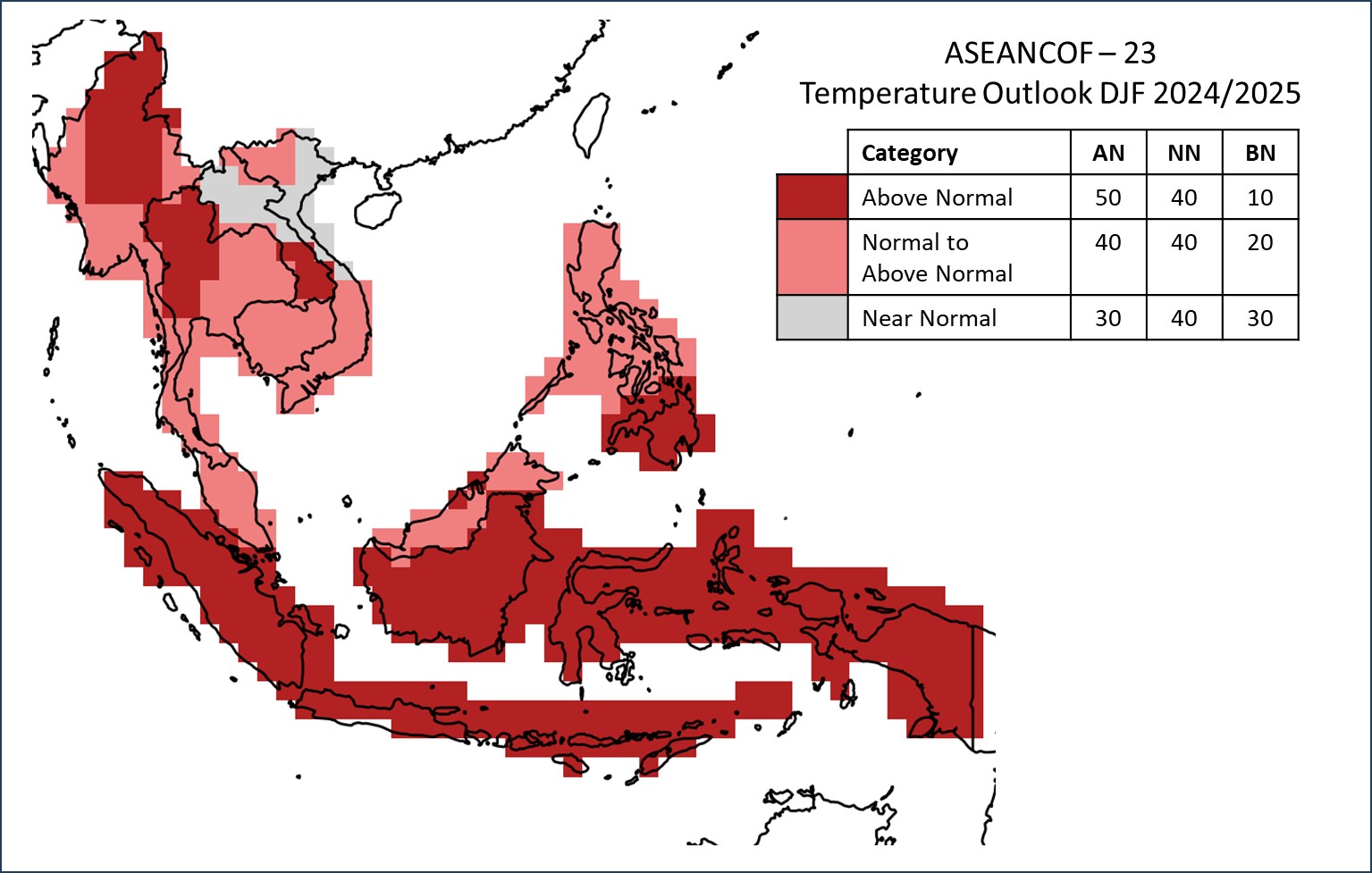
TEMPERATURE

For the upcoming boreal (Northern Hemisphere) winter season (DJF 2024/2025):
Near- to above-normal or above-normal temperature is predicted over most of the ASEAN region. The exception is over northern Lao PDR, and northeast and central Viet Nam, where near-normal temperature is predicted. The highest chance of above-normal temperature is over northern and central Myanmar, northern Thailand, southern Lao PDR, Singapore, the southern Philippines, and Brunei Darussalam.

1This is based on the climatology period 1991-2020. However, at the national level, Myanmar is using the 1981-2010 climatology as their base period.

Refer to Annex A for reference on what is meant by “above, near, or below normal” in the outlook. For more information on the boreal (Northern Hemisphere) summer monsoon outlook and further updates on the national scale, the relevant NMHSs should be consulted (see Annex B).

Consensus Maps for DJF 2024/2025 Season

The following maps provide the probabilistic outlooks for DJF 2024/2025 season in terms of tercile categories of “Above Normal” (AN: upper tercile), “Near Normal (NN: middle tercile) and “Below Normal” (BN: lower tercile).

PROBABILISTIC RAINFALL OUTLOOK

image007

PROBABILISTIC TEMPERATURE OUTLOOK

image008

Meeting Documents

ASEANCOF-23 Outlook Bulletin

Acknowledgements

ASEANCOF would like to convey its appreciation to the NMHSs of the ASEAN Member States for sharing their national level forecasts, the Global Producing Centres, the Southeast Asia Regional Climate Centre – Network, RIMES, UN ESCAP, and other partners of ASEANCOF for sharing their products and expertise, and the World Meteorological Organization Regional Office in Asia and the Southwest Pacific (WMO-RAP) for their continued support of ASEANCOF. The Forum would also like to thank DMH Lao PDR for hosting the forum virtually, as well as trainers from RIMES and UK Met Office.

December 6, 2024

ASMC Bulletin (Issue #12, 2024)

ASMC Bulletin (Issue #12, 2024)

December 4, 2024

Subseasonal Weather Outlook (9 – 22 December 2024)

Subseasonal Weather Outlook (9 December – 22 2024)

Issued: 4 December 2024
First forecast week: 9 – 15 December 2024
Second forecast week: 16 – 22 December 2024

figure1

Figure 1: Rainfall Outlook

figure2

Figure 2: Temperature Outlook

Wetter conditions are predicted over parts of the central equatorial region and the southern Maritime Continent in Week 1 (25 November – 1 December). Wetter conditions are predicted to persist over much of the southern Maritime Continent in Week 2 (2 – 8 December).

Warmer than usual temperature is predicted over most of the Maritime Continent, apart from the southern region, and southern parts of Mainland Southeast Asia in the next fortnight (25 November – 8 December).

A weak Madden-Julian Oscillation (MJO) signal was present over the Indian Ocean (Phase 2) during mid-November. Most models predict this MJO signal to strengthen and propagate across the Indian Ocean (Phases 2 and 3), and then during the forecast period, propagate through the Maritime Continent (Phases 4 and 5).

The outlook is assessed for the region in general, where conditions are relative to the average conditions for the corresponding time of year. For specific updates on the national scale, the relevant ASEAN National Meteorological and Hydrological Services should be consulted.