Review of Regional Haze Situation for December 2024
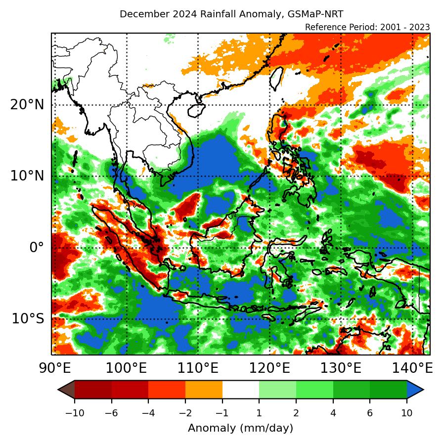
1.1 In December 2024, Northeast monsoon was well established over the ASEAN region as the prevailing low-level winds over most areas north of the Equator blew from the northeast or east except for the northern parts of the Mekong sub-region where the prevailing low-level winds were light and variable in direction. Over the areas south of the Equator, the prevailing low-level winds blew mainly from the west or northwest. (Figure 1).
1.2 Dry conditions were observed over most parts of the Mekong sub-region except for the coastal areas in the southern parts of Viet Nam where showers occurred (Figure 1). Wet weather was observed over rest of the ASEAN region with intense rainfall recorded over southern Thailand and the eastern coastal areas of Peninsular Malaysia (Figure 1). Intense rainfall was also recorded in the eastern parts of the Philippines (Figure 1) under the influence of Tropical Depression Querubin.
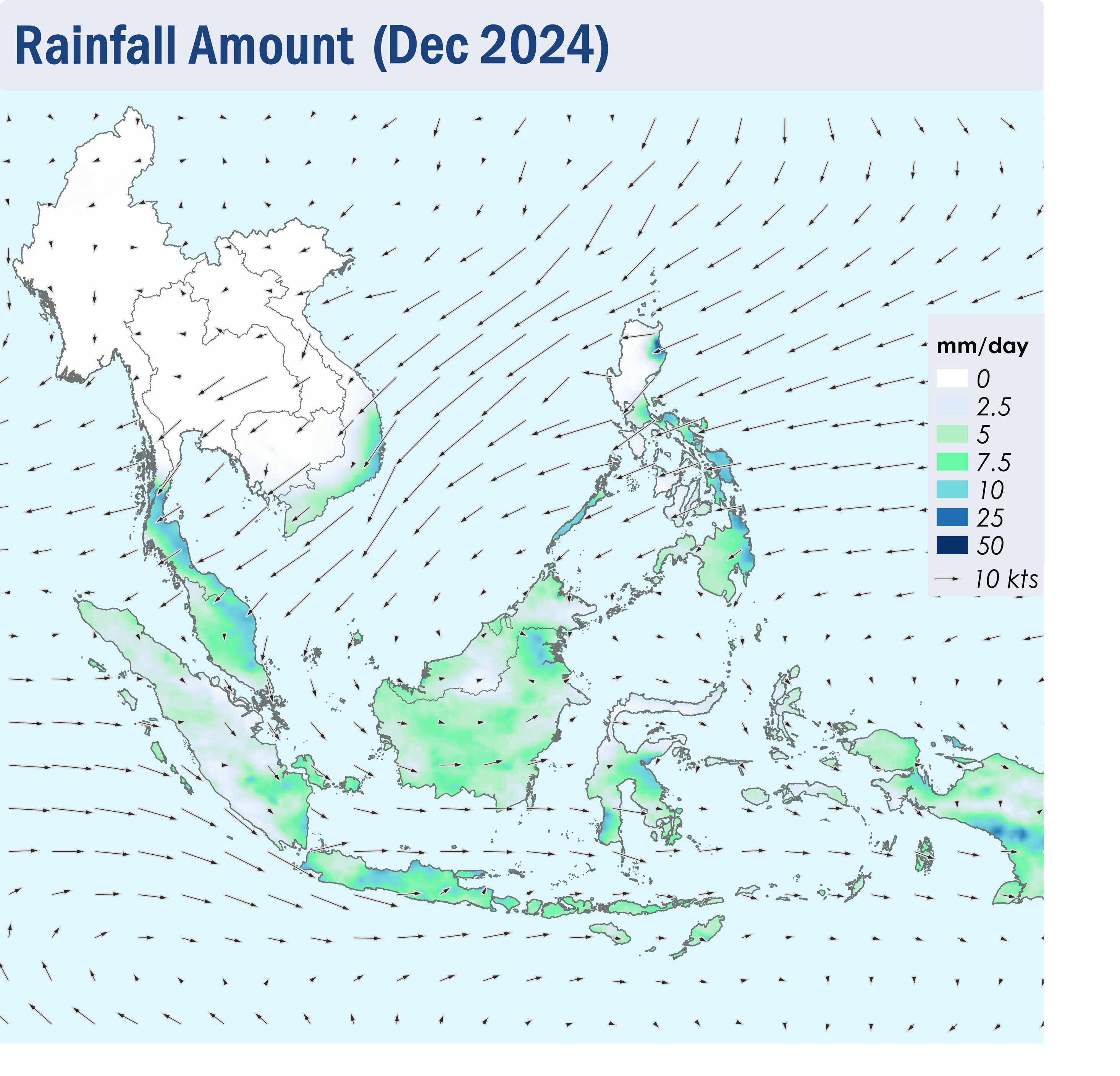
Figure 1: Average Daily Rainfall and Mean Winds for December 2024. (Source: JAXA GsMaP and GFS, respectively)
1.3 The overall hotspot counts in December 2024 over the ASEAN region were generally lower than or comparable to previous years.
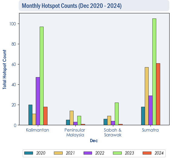
Figure 2: Hotspot counts for the southern ASEAN region for December (2020-2024) based on NOAA-20 satellite surveillance.
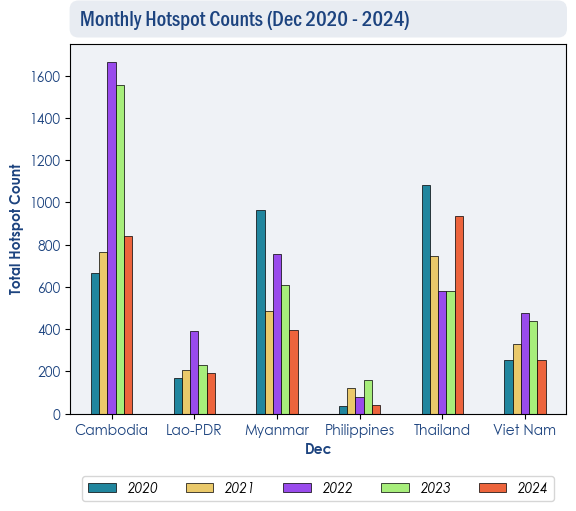
Figure 3: Hotspot counts for the northern ASEAN region for December (2020-2024) based on NOAA-20 satellite surveillance.
1.4 During the review period, isolated to scattered hotspots were detected in the Mekong sub-region (Figure 4 and 5). While most of the hotspots were short-lived, some were persistent and intense. A few slight localised smoke plumes were also observed to emanate from some hotspots detected in Cambodia, Lao PDR and Thailand (Figure 6). Although a few to isolated hotspots were detected in Sumatra and Kalimantan, the hotspot activities were generally subdued over the southern ASEAN region (Figure 4 and 5).
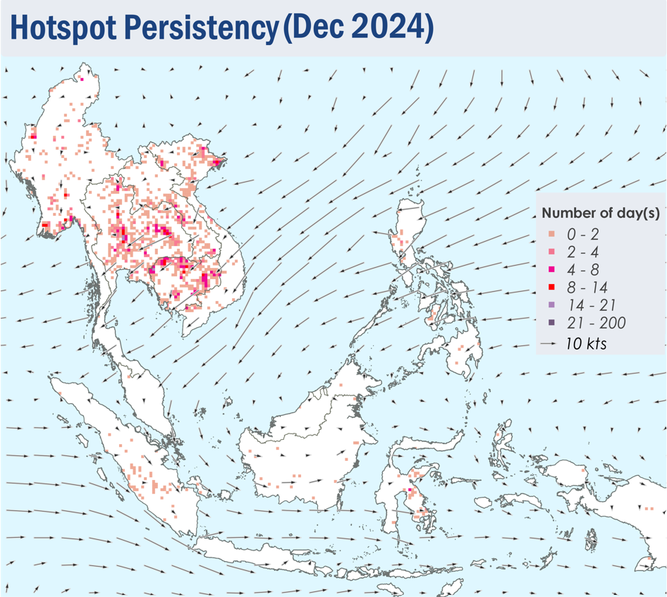
Figure 4: Distribution of hotspots detected in December 2024 based on NOAA-20 satellite surveillance.
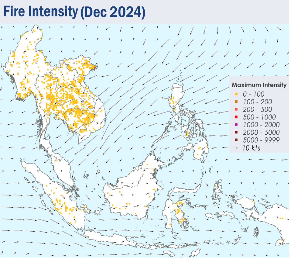
Figure 5: Maximum fire intensity in December 2024 based on NOAA-20 satellite surveillance.
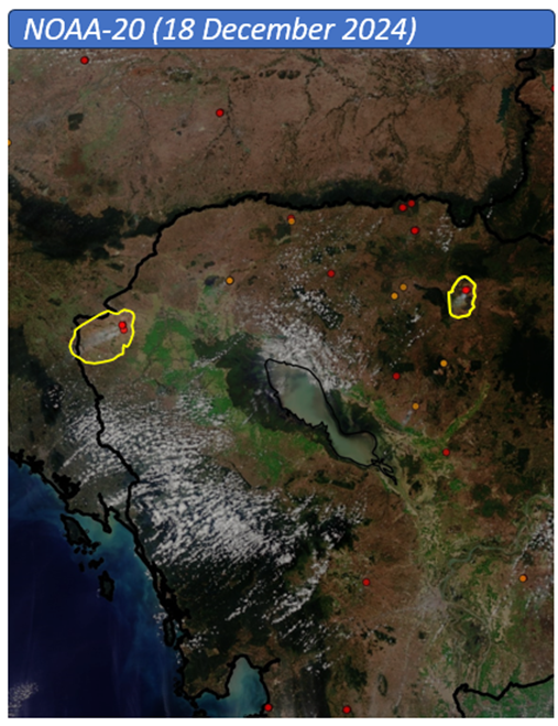
Figure 6: Slight localised smoke plumes observed over northern and western Cambodia on 18 December 2024, based on NOAA-20 satellite surveillance. (Source: NOAA-20 satellite surveillance)
Start of Dry Season for the Northern ASEAN Region
Northeast Monsoon conditions have become firmly established over the northern ASEAN region with the prevailing winds blowing predominantly from the northeast or east. In recent days, dry weather conditions were observed over the Mekong sub-region with gradually increasing hotspot counts. There were a total of 164 and 335 hotspots detected in the Mekong sub-region on 31 Dec 2024 and 1 Jan 2025 respectively.
The hotspot and smoke haze situation over the region may worsen as the dry conditions over the northern ASEAN region are likely to persist in the coming months.
ASMC Media Release – Start of Dry Season for the Northern ASEAN Region-2025

MEDIA RELEASE
START OF DRY SEASON FOR THE NORTHERN SOUTHEAST ASIA REGION
Increased risk of fires and transboundary haze in Mekong sub-region
Singapore, 02 January 2025 – The ASEAN Specialised Meteorological Centre (ASMC) has issued Alert Level 1 for the northern Southeast Asia region today, indicating the start of the dry season. In recent days, dry conditions were observed over most parts of the Mekong sub-region as the Northeast Monsoon becomes established. The hotspot and smoke haze situation over the sub-region may worsen in the coming months under prolonged dry weather conditions during the season.
2 The hotspot count in the Mekong sub-region has been increasing gradually since mid-December 2024, with a total of 164 and 335 hotspots detected in the sub-region on 31 December 2024 and 1 January 2025 respectively. While some localised smoke plumes/haze were detected in parts of Cambodia, Lao PDR and Thailand, no transboundary smoke haze occurrence has been observed so far.
3 Neutral or short-lived La Niña conditions are expected during the beginning of 2025, which could contribute to wetter-than-average conditions over some parts of the Southeast Asia region. However, its effects on rainfall may not be pronounced over the Mekong sub-region and there may still be a risk of escalated hotspot activities and transboundary smoke haze in the sub-region.
4 For regular and ad-hoc updates of the regional weather and smoke haze situation and early warnings, please visit the ASMC website at https://asmc.asean.org.
– End –
Subseasonal Weather Outlook (6 – 19 January 2025)
Issued: 2 January 2025
First forecast week: 6 – 12 January 2025
Second forecast week: 13 – 19 January 2025
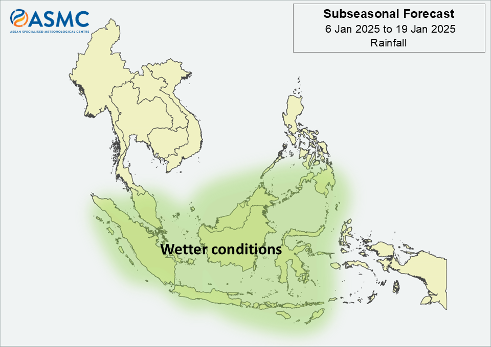
Figure 1: Rainfall Outlook
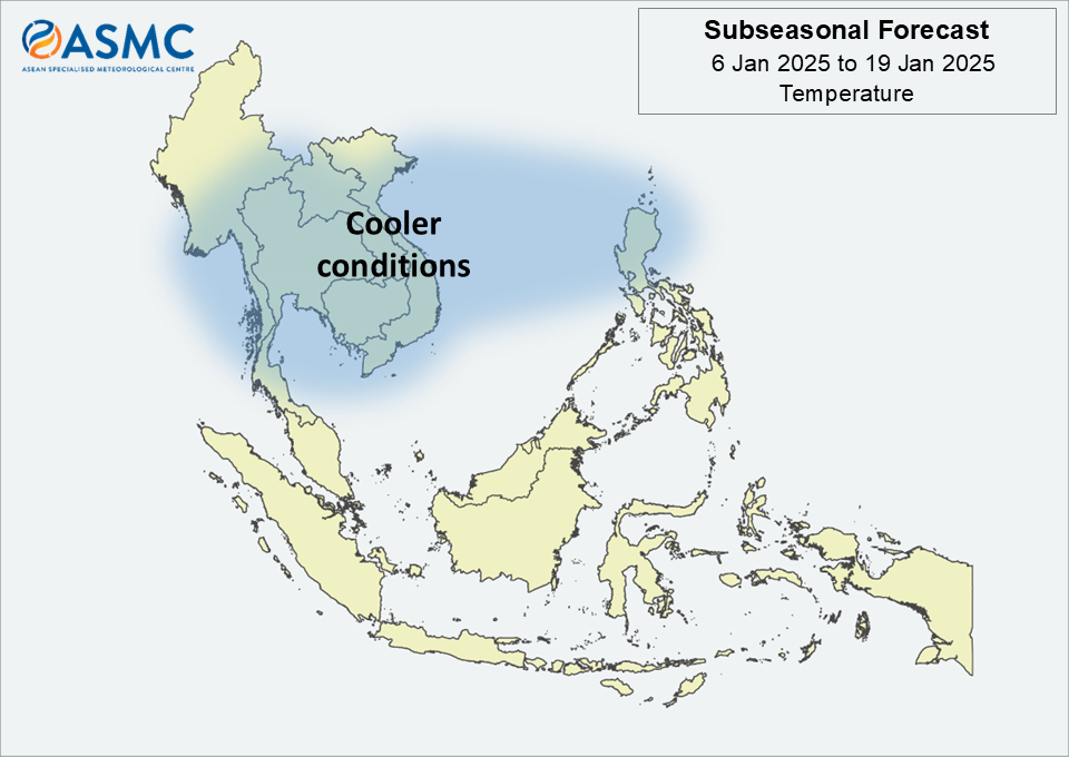
Figure 2: Temperature Outlook
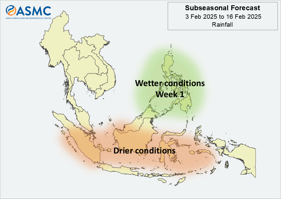
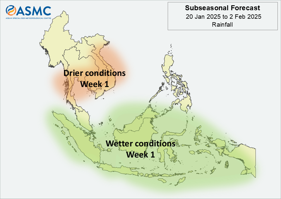
Wetter conditions are predicted over much of the central and western Maritime Continent in the next fortnight (6 – 19 January).
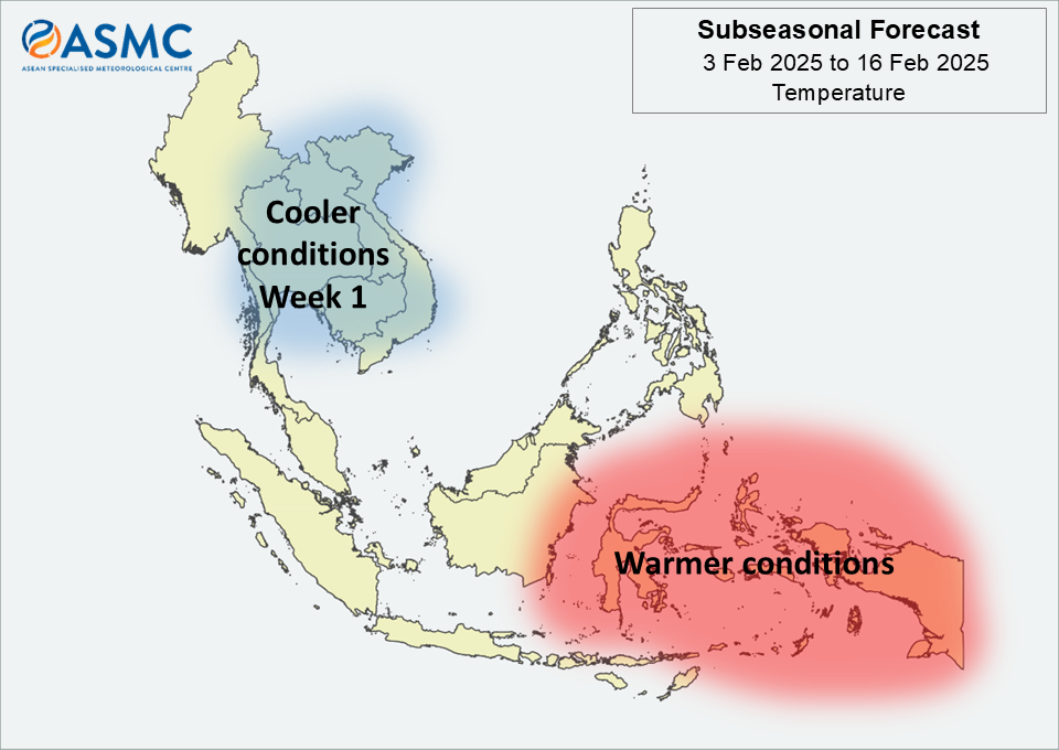
Cooler than usual temperature is expected over much of the northern ASEAN region in Week 1 (6 – 12 January). These cooler conditions may persist over Mainland Southeast Asia in Week 2 (13 – 19 January).
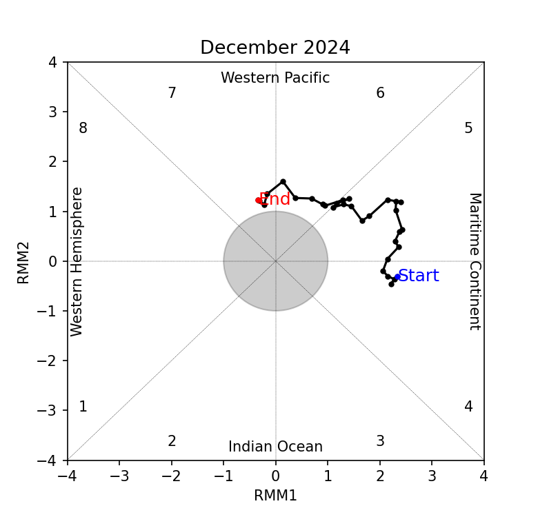
A Madden-Julian Oscillation (MJO) signal was present over the Western Pacific (Phase 7) at the start of the year. Models predict this MJO signal to become inactive during the first week of January, then re-emerge over the Western Hemisphere (Phases 8 and 1) in Week 1. Most models predict the signal to continue propagating eastwards through the Indian Ocean (Phases 2 and 3) during Week 2.
The outlook is assessed for the region in general, where conditions are relative to the average conditions for the corresponding time of year. For specific updates on the national scale, the relevant ASEAN National Meteorological and Hydrological Services should be consulted.