Monthly Archives: August 2025

August 28, 2025

Subseasonal Weather Outlook (1 – 14 September 2025)

Subseasonal Weather Outlook (1 – 14 September 2025)

Issued: 27 August 2025
First forecast week: 1 – 7 September 2025
Second forecast week: 8 – 14 September 2025

figure1

Figure 1: Rainfall Outlook

figure2

Figure 2: Temperature Outlook

Wetter conditions are predicted over much of the equatorial region in Week 2 (8 – 14 September).

No significant regional temperature anomalies are predicted in the next fortnight (1 – 14 September).

A Madden-Julian Oscillation (MJO) signal propagated from the Indian Ocean (Phases 2 and 3) towards the Maritime Continent (Phase 4) in the second half of August. Most models predict this signal to decay by the start of September, with no significant MJO activity predicted during the forecast period.

The outlook is assessed for the region in general, where conditions are relative to the average conditions for the corresponding time of year. For specific updates on the national scale, the relevant ASEAN National Meteorological and Hydrological Services should be consulted.

August 21, 2025

Review of Regional Weather for July 2025

Review of Regional Weather for July 2025


1. Overview

1.1 During July 2025, Southeast Asia experienced a mixed of below- to above-average rainfall, with the northwestern and parts of the central Maritime Continent as well as southern Mainland Southeast Asia experiencing below- to near-average rainfall while western and northern Mainland Southeast Asia and northern Philippines experienced above-average rainfall (Figure 1). The largest positive (wetter) anomalies were recorded over northern Philippines. However, there were some disagreements between GSMaP-NRT and CPC Unified Gauge datasets, with CPC Unified Gauge recording more intense below-average rainfall over Borneo and southern Mainland Southeast Asia.

1.2 The observed rainfall anomaly pattern of below-average rainfall over the Maritime Continent and southern Mainland Southeast Asia is mostly consistent with the predictions from the subseasonal weather outlooks for July 2025 (7 – 20 July 2025 and 21 July – 3 August 2025). The subseasonal weather outlooks also predicted the above-average rainfall over parts of Mainland Southeast Asia. The observations are also somewhat consistent with the seasonal outlook for July 2025, although the extent of the predicted region for below-normal rainfall is much smaller than the observed rainfall.

era5_rainfall_anomalies
cmorph_bld_rainfall_anomalies
Figure 1: Rainfall anomalies for July 2025 based on GSMaP-NRT data (left) and CPC Global Unified Gauge-based Analysis data (right). The climatological reference period is 2001-2024. Green colour denotes above-average rainfall (wetter), while orange denotes below-average rainfall (drier).


1.3 Below-average and near-average temperatures were recorded over much of northern Mainland Southeast Asia in July 2025, while above-average temperatures were recorded over most of the Maritime Continent and southern Mainland Southeast Asia (Figure 2). The coldest anomalies (-1°C – -2°C below average) were recorded over central Myanmar while the warmest anomalies (2°C – 3°C above average) were recorded over central Sumatra.

era5_temperature_anomalies
Figure 2: Temperature anomalies for July 2025 based on ERA-5 reanalysis. The climatological reference period is 2001-2024. Red colour denotes above-average temperature (warmer), while blue denotes below-average temperature (colder).


2. Climate Drivers

2.1 There was no discernible Madden-Julian Oscillation (MJO) signal at the start of July based on the RMM diagram (Figure 3). In the middle of Week 2, an MJO signal developed over the Maritime Continent (Phase 4) which then propagated eastwards to the Western Pacific (Phases 6 and 7) by the end of Week 3. The MJO signal continued to propagate through the Western Pacific before decaying at the end of the month. At this time of the year, Phases 4 and 5 tend to bring wetter conditions to parts of the Maritime Continent while Phase 7 tends to bring drier conditions.

mjo_phase_diagram


Figure 3: The MJO phase diagram. The diagram illustrates the movement of the MJO through different phases, which correspond to different locations along the equator (denoted in the text with the first day of the month in blue and the last day of the month in red). The distance of the index from the centre of the diagram is related to the strength of the MJO. Values within the grey circle are considered weak or indiscernible (data from the Bureau of Meteorology, Australia).


2.2 ENSO-neutral conditions were present in July 2025.


August 14, 2025

Subseasonal Weather Outlook (18 – 31 August 2025)

Subseasonal Weather Outlook (18 – 31 August 2025)

Issued: 14 August 2025
First forecast week: 18 – 24 August 2025
Second forecast week: 25 – 31 August 2025

figure1

Figure 1: Rainfall Outlook

figure2

Figure 2: Temperature Outlook

Drier conditions are predicted over parts of the western Maritime Continent in Week 1 (18 – 24 August). Warmer than usual temperatures are predicted over the same area in the next fortnight (18 – 31 August).

In Week 1 (18 – 24 August), wetter conditions and cooler than usual temperatures are predicted over parts of the southern and eastern Maritime Continent.

A weak Madden-Julian Oscillation (MJO) signal propagated from the Western Hemisphere and Africa (Phases 8 and 1) towards the Indian Ocean in the first week of August. Most models predict this signal to continue propagating over the Indian Ocean (Phases 2 and 3), then weaken and become indiscernible in Week 1. Models disagree if the MJO signal will reach the Maritime Continent (Phase 4) before decaying.

The outlook is assessed for the region in general, where conditions are relative to the average conditions for the corresponding time of year. For specific updates on the national scale, the relevant ASEAN National Meteorological and Hydrological Services should be consulted.

August 12, 2025

Alert20250812 – Downgrade to Alert Level 1 for the Southern ASEAN Region

Downgrade to Alert Level 1 for the Southern ASEAN Region

Wetter conditions have returned to many parts of the Southern ASEAN region since early August, helping to improve the regional hotspot and smoke haze situation, with low hotspot counts and no significant smoke plumes observed over the past few days.  The region continues to experience occasional rainfall, which is forecast to persist in the coming weeks. The Alert Level is being lowered to reflect the reduced likelihood of transboundary haze.  While the risk of transboundary haze is low, isolated hotspots and localised smoke plumes may still occur over drier areas.

As the region is still in its traditional dry season, there remains a possibility that hotspot activity and smoke haze condition could intensify again. ASMC will continue to monitor the situation and raise the alert if it escalates.

August 5, 2025

Review of Regional Haze Situation for July 2025

Review of Regional Haze Situation for July 2025

1.1 Southwest Monsoon conditions persisted over the ASEAN region throughout July 2025. The prevailing winds over the northern ASEAN region blew from the southwest to west. Over the southern ASEAN region, the prevailing winds blew mostly from the southeast to south, except for the winds over the equatorial region which were light and variable in direction (Figure 1).

1.2 Showers were observed over the southern ASEAN region during the first half of July 2025, apart from Java and the Lesser Sunda Islands where it was dry (Figure 1). During the latter half of the review period, dry weather was observed over parts of Kalimantan, Peninsular Malaysia and Sumatra. On 19 July 2025, the Alert Level 2 for the southern ASEAN region was activated due to an escalation of hotspot and smoke haze activities and heightened risk of transboundary smoke haze occurrences in the region. In contrast, the northern ASEAN region experienced wet weather in July 2025, with heavy precipitation recorded over the northern parts of the Philippines due to the influence of Typhoon CO-MAY and Tropical Cyclone WIPHA.

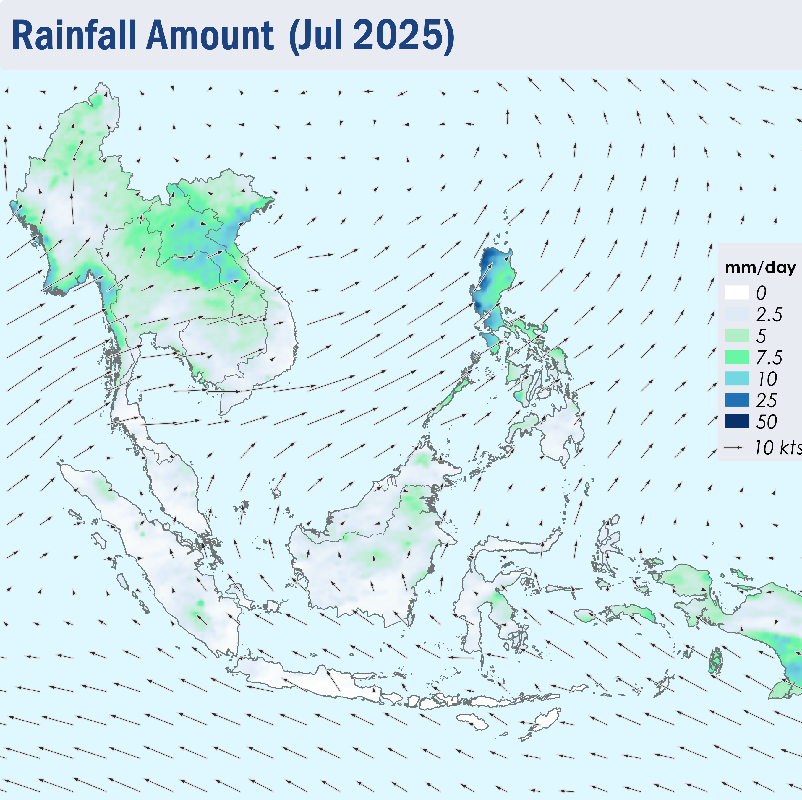
Figure 1: Average Daily Rainfall and Mean Winds for July 2025. (Source: JAXA GsMaP and GFS, respectively)


1.3 There was a rise in hotspot activity over the southern ASEAN region due to periods of drier conditions, with hotspot counts higher or comparable to previous years (Figure 2). Notably, Sumatra saw the highest hotspot count over the last 5 years. The hotspot counts for the northern ASEAN region were lower or comparable to the past few years (Figure 3).


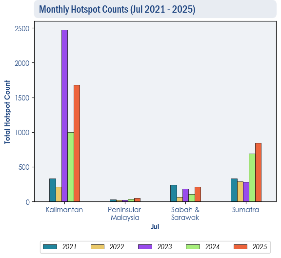
Figure 2: Hotspot counts for the southern ASEAN region for July (2021-2025) based on NOAA-20 satellite surveillance.


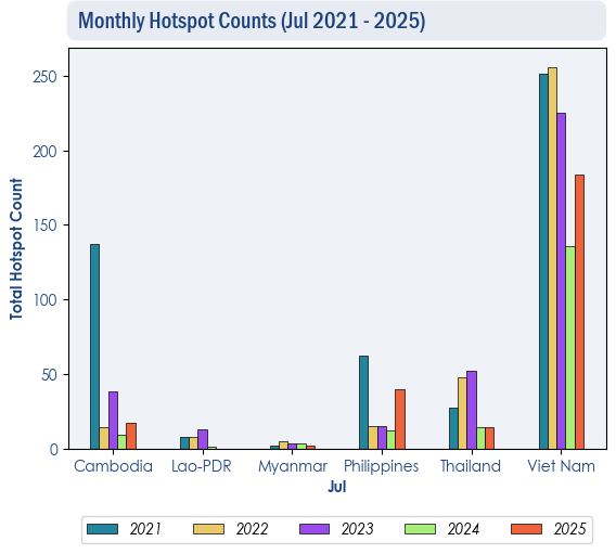
Figure 3: Hotspot counts for the northern ASEAN region for July (2021-2025) based on NOAA-20 satellite surveillance.


1.4 During the latter half of July 2025, there was an increase in hotspot activities in most of the southern ASEAN region, particularly over the western parts of Kalimantan and the central parts of Sumatra where more intense and persistent fires were observed (Figure 4). Slight to moderate smoke plumes were observed over parts of Borneo, Sumatra and Peninsular Malaysia, with transboundary smoke haze observed to drift from the central parts of Sumatra into Peninsular Malaysia and from the western parts of Kalimantan into Sarawak (Figure 6, 7, 8). The hotspot activity over the northern ASEAN region remained subdued under the prevailing wet weather (Figure 4).


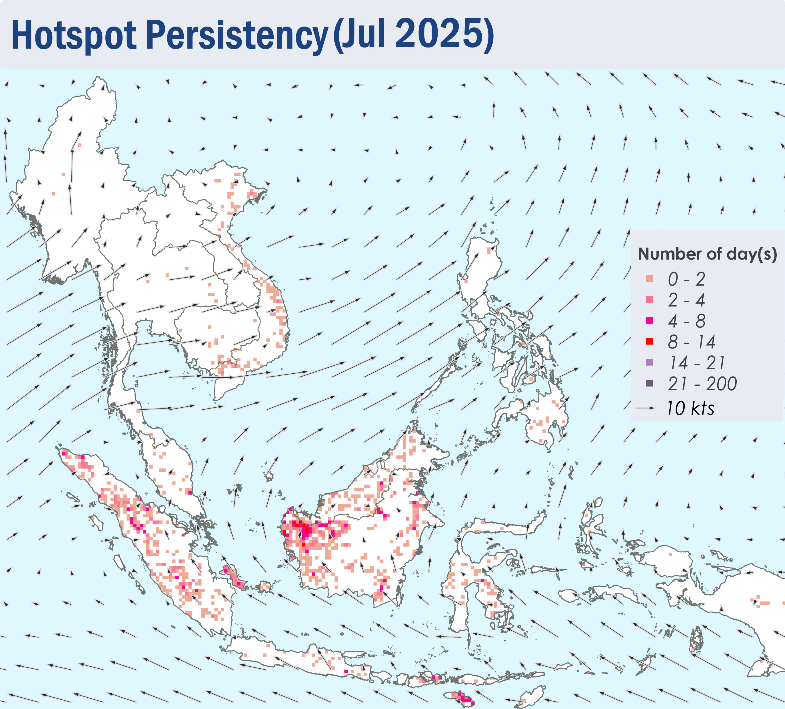
Figure 4: Distribution of hotspots detected in July 2025 based on NOAA-20 satellite surveillance.


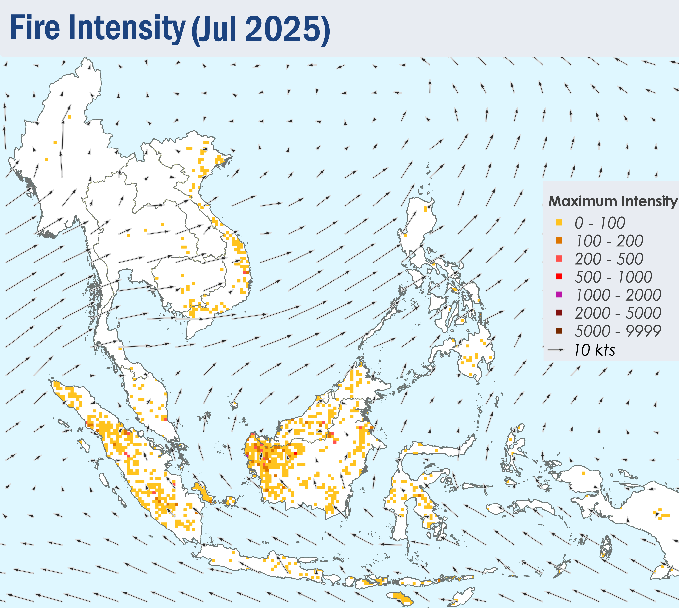
Figure 5: Maximum fire intensity in July 2025 based on NOAA-20 satellite surveillance.


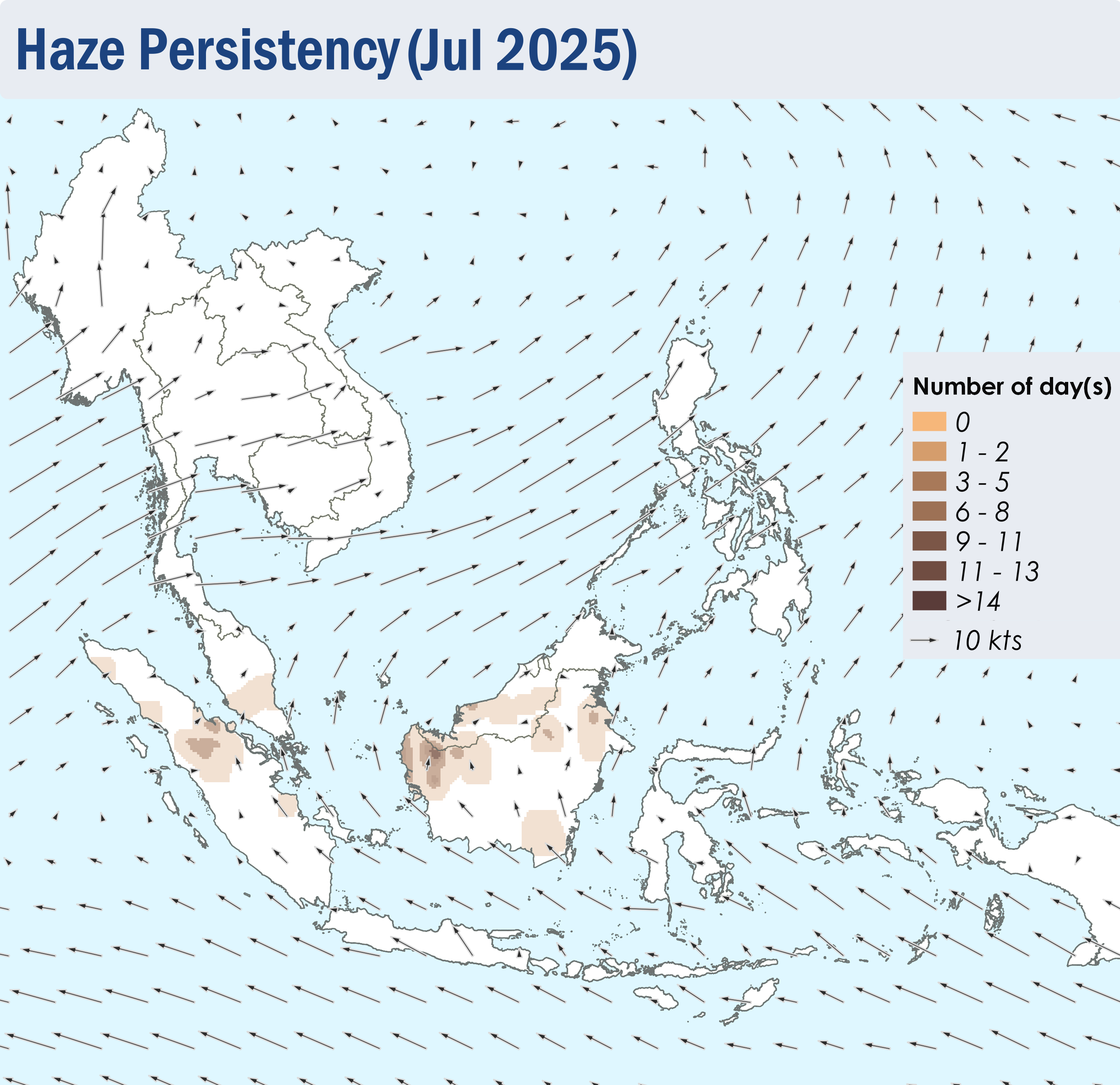
Figure 6: Number of days with moderate to dense smoke haze observed in July 2025 based on satellite imagery, ground observations, and air quality reports.


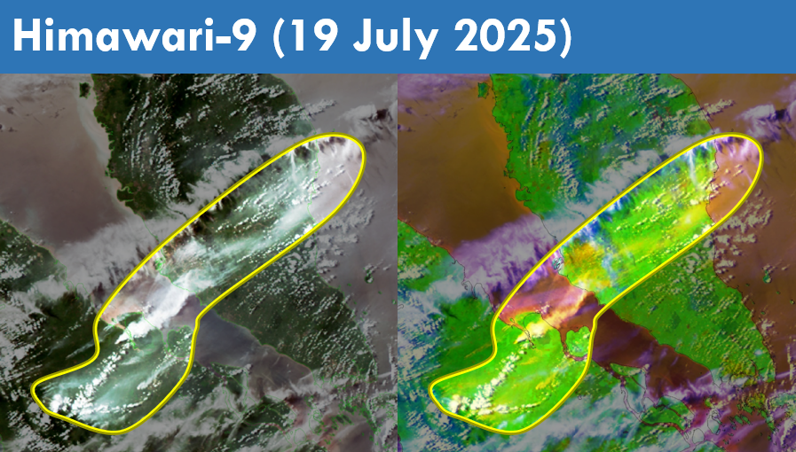
Figure 7: Moderate smoke plumes observed to emanate from hotspots detected in the central parts of Sumatra and drift northeastwards into Peninsular Malaysia on 19 July 2025. (Source: Himawari-9 satellite surveillance)


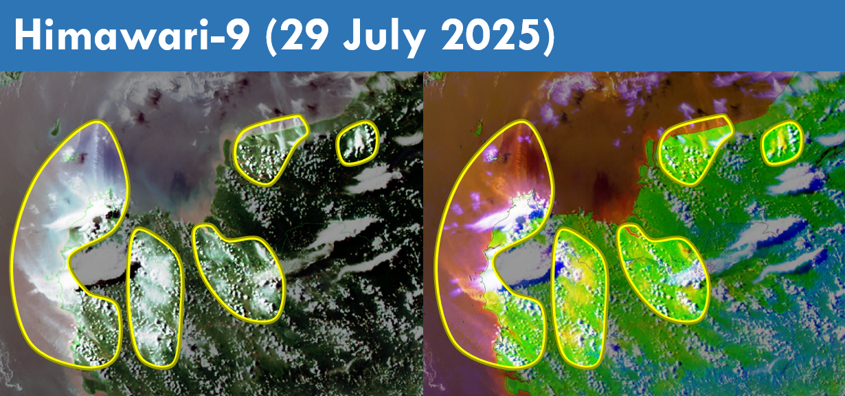
Figure 8: Slight to moderate smoke plumes were observed emanating from hotspots detected in Sarawak and the western parts of Kalimantan. Transboundary smoke plumes were observed drifting northwards from the western parts of Kalimantan into Sarawak on 29 July 2025. (Source: Himawari-9 satellite surveillance)