Category Archives: Fortnightly Weather Outlook

CR58

January 21, 2022

Subseasonal Weather Outlook (24 January – 6 February 2022)

Subseasonal Weather Outlook (24 January – 6 February 2022)

Issued 21 January 2022
First forecast week: 24 January – 30 January
Second forecast week: 31 January – 6 February

figure1

Figure 1: Rainfall Outlook

figure2

Figure 2: Temperature Outlook


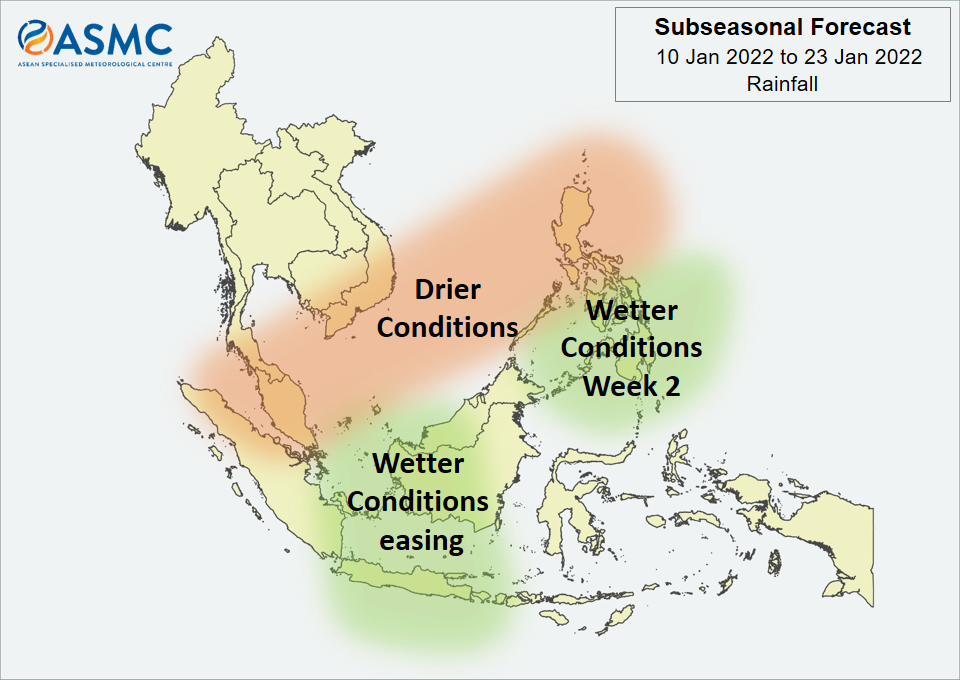
In Week 1 (24 – 30 January), drier conditions are predicted over much of the western and southern Maritime Continent. Also in Week 1, wetter conditions are predicted over northeastern parts of the Maritime Continent (in particular for the Philippines).

For temperature, warmer than usual conditions are predicted for much of the central part of Southeast Asia (central and eastern Mainland Southeast Asia, the western half of the Maritime Continent) and the northern Philippines in Week 1 (24 – 30 January). In Week 2 (31 January – 6 February), these warmer conditions are expected to ease, apart from over the coastal regions of eastern Mainland Southeast Asia.

Cooler than usual conditions are predicted for northwestern Mainland Southeast Asia in the next fortnight (24 January – 6 February).

By the middle of January, the previous Madden-Julian Oscillation (MJO) signal had decayed. Most models predict no significant MJO activity during the forecast period.

The outlook is assessed for the region in general, where conditions are relative to the average conditions for the corresponding time of year. For specific updates on the national scale, the relevant ASEAN National Meteorological and Hydrological Services should be consulted.

January 7, 2022

Subseasonal Weather Outlook (10 – 23 January 2022)

Subseasonal Weather Outlook (10 – 23 January 2022)

Issued 7 January 2022
First forecast week: 10 January – 16 January
Second forecast week: 17 January – 23 January

figure1

Figure 1: Rainfall Outlook

figure2

Figure 2: Temperature Outlook


Drier conditions are predicted in the next fortnight (10 – 23 January) over a band that includes the Malay Peninsula, southern Viet Nam, and much of the northern Philippines and surrounding area.

Wetter conditions are predicted in Week 1 (10 – 16 January) over central parts of the Maritime Continent (in particular for western Borneo and Java). These wetter conditions are expected to ease in Week 2 (17 – 23 January), although there is a chance that they remain over the region around Java. Also in Week 2, wetter conditions are predicted to develop over parts of the central and southern Philippines.

No significant regional temperature anomalies are expected in the next fortnight (10 – 23 January).

Based on the RMM index, a Madden-Julian Oscillation (MJO) signal was present over the Western Pacific (Phase 7) at the start of January, although the signal has been less coherent in part due to the background La Niña state. As with the previous outlook, while some models predict this signal to propagate slowly eastwards, others predict the signal to decay in Phase 7.

The outlook is assessed for the region in general, where conditions are relative to the average conditions for the corresponding time of year. For specific updates on the national scale, the relevant ASEAN National Meteorological and Hydrological Services should be consulted.

December 24, 2021

Subseasonal Weather Outlook (27 December 2021 – 9 January 2022)

Subseasonal Weather Outlook (27 December 2021 – 9 January 2022)

 
Issued: 24 December 2021
First forecast week: 27 December – 2 January
Second forecast week: 3 January – 9 January

figure1

Figure 1: Rainfall Outlook

figure2

Figure 2: Temperature Outlook


In Week 1 (27 December – 2 January), wetter conditions are expected over much of the Philippines, northern Borneo and northern Sulawesi. However, these wetter conditions are highly dependent on the tropical cyclone development. Also in Week 1, an increased chance of wetter conditions is predicted over parts of Viet Nam and the Malay Peninsula.

Cooler than usual temperature is expected over much of central and eastern Mainland Southeast Asia in Week 1 (27 December – 2 January) associated with a strengthening of the northeasterly winds, bringing cooler air from the northern Asian landmass. In Week 2 (3 – 9 January), these cooler conditions are expected to ease for much of this area.

Warmer than usual temperature is expected over southeastern parts of the Maritime Continent in Week 1 (27 December – 2 January).

Based on the RMM index, a Madden-Julian Oscillation (MJO) signal was present over the Western Pacific (Phases 6 and 7) in December. Some models predict this signal to continue propagating slowly through the Western Pacific, while others predict the signal to decay in Phase 7.
 
The outlook is assessed for the region in general, where conditions are relative to the average conditions for the corresponding time of year. For specific updates on the national scale, the relevant ASEAN National Meteorological and Hydrological Services should be consulted.

December 10, 2021

Subseasonal Weather Outlook (13 – 26 December 2021)

Subseasonal Weather Outlook (13 – 26 December 2021)

Issued 10 December 2021
First forecast week: 13 December – 19 December
Second forecast week: 20 December – 26 December

figure1

Figure 1: Rainfall Outlook

figure2

Figure 2: Temperature Outlook


In Week 1 (13 – 19 December), wetter conditions are expected over central parts of the Philippines and the eastern coastal regions of Mainland Southeast Asia. However, these wetter conditions are highly dependent on the tropical cyclone development. Also in Week 1, wetter conditions are expected over both western and eastern parts of the equatorial region.

Drier conditions are expected over the central equatorial region in Week 2 (20 – 26 December).

Warmer than usual temperature is expected over the southeastern parts of the Maritime Continent in Week 1 (13 – 19 December).

A Madden-Julian Oscillation (MJO) signal propagated eastward from the eastern Maritime Continent (Phase 5) to the Western Pacific (Phases 6 and 7) in the first fortnight of December. However, most models predict this signal to decay in the second week of the forecast period as it propagates eastwards towards Western Hemisphere and Africa (Phase 8).
 
The outlook is assessed for the region in general, where conditions are relative to the average conditions for the corresponding time of year. For specific updates on the national scale, the relevant ASEAN National Meteorological and Hydrological Services should be consulted.

November 26, 2021

Subseasonal Weather Outlook (29 November – 12 December 2021)

Subseasonal Weather Outlook (29 November – 12 December 2021)

Issued 26 November 2021
First forecast week: 29 November – 5 December
Second forecast week: 6 November – 12 December

figure1

Figure 1: Rainfall Outlook

figure2

Figure 2: Temperature Outlook


Wetter conditions are expected over southern Mainland Southeast Asia, parts of the Philippines, and the southeastern Maritime Continent in Week 1 (29 November – 5 December). These wetter conditions are likely to persist over coastal parts of Viet Nam and the Philippines in Week 2 (6 – 12 December).

Drier conditions are expected over the western and central equatorial region in Week 1 (29 November – 5 December).

For temperature, cooler than usual temperature is expected over much of Mainland Southeast Asia in the next fortnight (29 November – 12 December). Warmer than usual temperature is expected over the western and central equatorial region in Week 1 (29 November – 5 December), in line with the drier conditions predicted.

No coherent Madden-Julian Oscillation (MJO) signal was present towards the end of November. Some models predict an MJO signal to propagate eastward through the Maritime Continent (Phases 4 and 5) and the Western Pacific (Phases 6 and 7) in the forecast period.

The outlook is assessed for the region in general, where conditions are relative to the average conditions for the corresponding time of year. For specific updates on the national scale, the relevant ASEAN National Meteorological and Hydrological Services should be consulted.

November 12, 2021

Subseasonal Weather Outlook (15 – 28 November 2021)

Subseasonal Weather Outlook (15 – 28 November 2021)

Issued 12 November 2021
First forecast week: 15 November – 21 November
Second forecast week: 22 November – 28 November

figure1

Figure 1: Rainfall Outlook

figure2

Figure 2: Temperature Outlook


Wetter conditions are expected over much of western and southern Mainland Southeast Asia in Week 1 (15 – 21 November). These wetter conditions are likely to persist over western Mainland Southeast Asia, but likely to ease over southern Mainland Southeast Asia, in Week 2 (22 – 28 November).

For the Maritime Continent, wetter conditions are expected over the southern parts in the next fortnight (15 – 28 November). Elsewhere, drier conditions are expected over the western and central equatorial region in Week 1 (15 – 21 November).

Warmer than usual temperature is expected over the western and central equatorial region in Week 1 (15 – 21 November), in line with the drier conditions predicted.

No clear MJO signal was present at the start of November. Most models predict the MJO to remain indiscernible based on the RMM Index during the forecast period.

The outlook is assessed for the region in general, where conditions are relative to the average conditions for the corresponding time of year. For specific updates on the national scale, the relevant ASEAN National Meteorological and Hydrological Services should be consulted.

October 29, 2021

Subseasonal Weather Outlook (1 – 14 November 2021)

Subseasonal Weather Outlook (1 – 14 November 2021)

Issued 29 October 2021
First forecast week: 1 November – 7 November
Second forecast week: 8 November – 14 November

figure1

Figure 1: Rainfall Outlook

figure2

Figure 2: Temperature Outlook


Over most of the southern ASEAN region, wetter conditions are predicted in the next fortnight (1 – 14 November). There is also an increased chance of wetter conditions in the region around 10°N (southern parts of Thailand, Cambodia, and Viet Nam), although with a lower likelihood than for the southern ASEAN region.

In Week 1 (1 – 7 November), wetter conditions are predicted over parts of northern Mainland Southeast Asia (parts of Myanmar and northern Lao PDR). Also in Week 1, drier conditions are predicted over eastern Mainland Southeast Asia and northern Philippines.

Warmer than usual temperature is predicted over much of the northern ASEAN region in Week 1 (1 – 7 November). These warmer conditions are expected to ease in Week 2 (8 – 14 November), apart from over Myanmar and northern Philippines.

No clear MJO signal was present at the end of October based on the RMM Index.
Most models predict no clear MJO signal for the start of the forecast period, although some models suggest an MJO signal to develop over the Indian Ocean (Phases 2 and 3) in Week 1 and then propagate eastwards over the Maritime Continent (Phases 4 and 5) in Week 2.

 
The outlook is assessed for the region in general, where conditions are relative to the average conditions for the corresponding time of year. For specific updates on the national scale, the relevant ASEAN National Meteorological and Hydrological Services should be consulted.

October 15, 2021

Subseasonal Weather Outlook (18 – 31 October 2021)

Subseasonal Weather Outlook (18 – 31 October 2021)

Issued 15 October 2021
First forecast week: 18 October – 24 October
Second forecast week: 25 October – 31 October

figure1

Figure 1: Rainfall Outlook

figure2

Figure 2: Temperature Outlook


Over most of the Maritime Continent, wetter conditions are predicted in the next fortnight (18 – 31 October). The highest likelihood for wetter conditions is for the equatorial region in Week 1 (18 – 24 October), while the highest likelihood is over central and eastern parts of the Maritime Continent in Week 2 (25 – 31 October).

Over Mainland Southeast Asia in Week 1 (18 – 24 October), wetter conditions are predicted apart from over western Mainland Southeast Asia. In Week 2 (25 – 31 October), these wetter conditions are generally expected to ease, although a small increase in wetter conditions remains over southern Mainland Southeast Asia.

No significant regional temperature anomalies are expected in the next fortnight (18 – 31 October).

A Madden-Julian Oscillation (MJO) signal propagated eastward from the Maritime Continent (Phases 4 and 5) towards the Western Pacific (Phase 6) in the first two weeks of October. However, most models predict this signal to decay, with no significant MJO activity during the outlook period.
 
The outlook is assessed for the region in general, where conditions are relative to the average conditions for the corresponding time of year. For specific updates on the national scale, the relevant ASEAN National Meteorological and Hydrological Services should be consulted.

October 1, 2021

Subseasonal Weather Outlook (4 – 17 October 2021)

Subseasonal Weather Outlook (4 – 17 October 2021)

Issued 1 October 2021
First forecast week: 4 October – 10 October
Second forecast week: 11 October – 17 October

figure1

Figure 1: Rainfall Outlook

figure2

Figure 2: Temperature Outlook


Wetter conditions are expected over much of the northern ASEAN region in the next fortnight (4 – 17 October). In Week 1 (4 – 10 October), wetter conditions are predicted over the Philippines, as well as southern and eastern Mainland Southeast Asia. These wetter conditions are likely to become more widespread in Week 2 (11 – 17 October), covering the Philippines and most of Mainland Southeast Asia, apart from northern Myanmar.

Drier conditions are expected over the western Maritime Continent and parts of Borneo in the next fortnight (4 – 17 October).

Warmer than usual temperatures are predicted over much of the equatorial region in the next fortnight (4 – 17 October), including the region where drier conditions are predicted.

A Madden-Julian Oscillation (MJO) signal appeared to be developing over the Maritime Continent (Phase 4) at the end of September based on the RMM Index. Models predict this signal to propagate eastwards for Week 1 of the forecast period. Some models predict this signal to continue propagating through the Western Pacific (Phases 6 and 7) in Week 2, while others predict the signal to decay in Phase 5.
 
The outlook is assessed for the region in general, where conditions are relative to the average conditions for the corresponding time of year. For specific updates on the national scale, the relevant ASEAN National Meteorological and Hydrological Services should be consulted.

September 17, 2021

Subseasonal Weather Outlook (20 September – 3 October 2021)

Subseasonal Weather Outlook (20 September – 3 October 2021)

Issued 17 September 2021
First forecast week: 20 September – 26 September
Second forecast week: 27 September – 3 October

figure1

Figure 1: Rainfall Outlook

figure2

Figure 2: Temperature Outlook


Wetter conditions are expected to continue over much of the Maritime Continent in the next fortnight (20 September – 3 October), with the highest probability for wetter conditions over parts of the southeastern Maritime Continent.

Wetter conditions are also expected in Week 1 (20 – 26 September) over most parts of Mainland Southeast Asia as well as the northern half of the Philippines. The wetter conditions over northern Philippines and northern Viet Nam are highly dependent on tropical cyclone development.

No significant regional temperature anomalies are expected in the next fortnight (20 September – 3 October).

A Madden-Julian Oscillation (MJO) signal was present over the Indian Ocean (Phase 3) in the middle of September based on the RMM Index. Most models predict this signal to weaken and become indiscernible around the start of the forecast period.
 
The outlook is assessed for the region in general, where conditions are relative to the average conditions for the corresponding time of year. For specific updates on the national scale, the relevant ASEAN National Meteorological and Hydrological Services should be consulted.