Category Archives: Regional Weather Outlook for Year 2024

December 18, 2024

Subseasonal Weather Outlook (23 December 2024 – 5 January 2025)

Subseasonal Weather Outlook (23 December 2024 – 5 January 2025)

Issued: 18 December 2024
First forecast week: 23 – 29 December 2024
Second forecast week: 30 December 2024 – 5 January 2025

figure1

Figure 1: Rainfall Outlook

figure2

Figure 2: Temperature Outlook

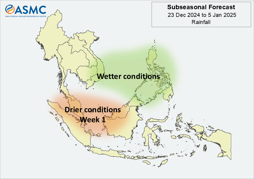
In Week 1 (23 – 29 December), drier conditions are predicted over parts of the western Maritime Continent, while wetter conditions are predicted over southeastern Mainland Southeast Asia and the northeastern Maritime Continent. These wetter conditions are likely to extend into Week 2 (30 December – 5 January).

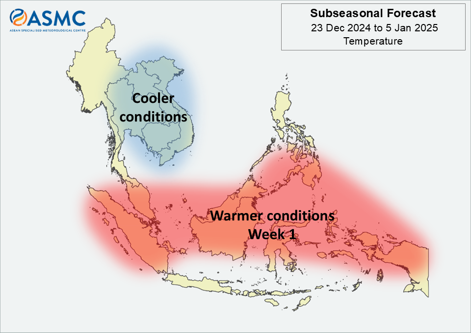
Warmer than usual temperature is predicted over the equatorial region in Week 1 (23 – 29 December). Cooler than usual temperature is predicted over central and eastern Mainland Southeast Asia in the next fortnight (23 December – 5 January).

A Madden-Julian Oscillation (MJO) signal was present over the Maritime Continent (Phase 5) towards the middle of December. Most models predict this signal to continue propagating through the Western Pacific (Phases 6 and 7) towards the Western Hemisphere (Phase 8) during the forecast period. However, some models predict a weakening of the signal while it propagates through the Western Pacific (Phases 6 and 7), becoming temporarily indiscernible.

The outlook is assessed for the region in general, where conditions are relative to the average conditions for the corresponding time of year. For specific updates on the national scale, the relevant ASEAN National Meteorological and Hydrological Services should be consulted.

December 4, 2024

Subseasonal Weather Outlook (9 – 22 December 2024)

Subseasonal Weather Outlook (9 December – 22 2024)

Issued: 4 December 2024
First forecast week: 9 – 15 December 2024
Second forecast week: 16 – 22 December 2024

figure1

Figure 1: Rainfall Outlook

figure2

Figure 2: Temperature Outlook

Wetter conditions are predicted over parts of the central equatorial region and the southern Maritime Continent in Week 1 (25 November – 1 December). Wetter conditions are predicted to persist over much of the southern Maritime Continent in Week 2 (2 – 8 December).

Warmer than usual temperature is predicted over most of the Maritime Continent, apart from the southern region, and southern parts of Mainland Southeast Asia in the next fortnight (25 November – 8 December).

A weak Madden-Julian Oscillation (MJO) signal was present over the Indian Ocean (Phase 2) during mid-November. Most models predict this MJO signal to strengthen and propagate across the Indian Ocean (Phases 2 and 3), and then during the forecast period, propagate through the Maritime Continent (Phases 4 and 5).

The outlook is assessed for the region in general, where conditions are relative to the average conditions for the corresponding time of year. For specific updates on the national scale, the relevant ASEAN National Meteorological and Hydrological Services should be consulted.

November 21, 2024

Subseasonal Weather Outlook (25 November – 8 December 2024)

Subseasonal Weather Outlook (25 November – 8 December 2024)

Issued: 20 November 2024
First forecast week: 25 November – 1 December 2024
Second forecast week: 2 December – 8 December 2024

figure1

Figure 1: Rainfall Outlook

figure2

Figure 2: Temperature Outlook

Wetter conditions are predicted over parts of the central equatorial region and the southern Maritime Continent in Week 1 (25 November – 1 December). Wetter conditions are predicted to persist over much of the southern Maritime Continent in Week 2 (2 – 8 December).

Warmer than usual temperature is predicted over most of the Maritime Continent, apart from the southern region, and southern parts of Mainland Southeast Asia in the next fortnight (25 November – 8 December).

A weak Madden-Julian Oscillation (MJO) signal was present over the Indian Ocean (Phase 2) during mid-November. Most models predict this MJO signal to strengthen and propagate across the Indian Ocean (Phases 2 and 3), and then during the forecast period, propagate through the Maritime Continent (Phases 4 and 5).

The outlook is assessed for the region in general, where conditions are relative to the average conditions for the corresponding time of year. For specific updates on the national scale, the relevant ASEAN National Meteorological and Hydrological Services should be consulted.

November 6, 2024

Subseasonal Weather Outlook (11 – 24 November 2024)

Subseasonal Weather Outlook (11 – 24 November 2024)

Issued: 11 November 2024
First forecast week: 11 November – 17 November 2024
Second forecast week: 18 November – 24 November 2024

figure1

Figure 1: Rainfall Outlook

figure2

Figure 2: Temperature Outlook

Wetter conditions are predicted over the southern Maritime Continent in the next fortnight (11 – 24 November). Wetter conditions are also predicted over parts of southeastern Mainland Southeast Asia in Week 2 (18 – 24 November).

Warmer than usual temperature is predicted over the Maritime Continent, apart from the southern region, and southern coastal parts of Mainland Southeast Asia in the next fortnight (11 – 24 November).

A Madden-Julian Oscillation (MJO) signal was present over the Western Hemisphere and Africa (Phases 8 and 1) at the beginning of November. Most models predict this MJO signal to weaken by the start of Week 1, although a few predict it to propagate across the Indian Ocean (Phases 2 and 3), reaching the Maritime Continent (Phase 4) by the end of Week 2.

The outlook is assessed for the region in general, where conditions are relative to the average conditions for the corresponding time of year. For specific updates on the national scale, the relevant ASEAN National Meteorological and Hydrological Services should be consulted.

October 24, 2024

Subseasonal Weather Outlook (28 October – 10 November 2024)

Subseasonal Weather Outlook (28 October – 10 November 2024)

Issued: 24 October 2024
First forecast week: 28 October – 3 November 2024
Second forecast week: 4 November – 10 November 2024

figure1

Figure 1: Rainfall Outlook

figure2

Figure 2: Temperature Outlook

Wetter conditions are predicted over the southern Maritime Continent in the next fortnight (28 October – 10 November).

Drier conditions are predicted over southeastern Mainland Southeast Asia and parts of the northern half of the Maritime Continent in Week 1 (28 October – 3 November).

Warmer than usual temperature is predicted over the Maritime Continent, apart from the southern region, in the next fortnight (28 October – 10 November). Cooler than usual temperature is predicted over much of eastern Mainland Southeast Asia in Week 1 (28 October – 3 November).

A Madden-Julian Oscillation (MJO) signal was present over the Maritime Continent (Phases 4 and 5) in the middle of October. This MJO signal is predicted to propagate through the Western Pacific (Phases 6 and 7) in Week 1. Most models predict the MJO signal to reach the Western Hemisphere and Africa (Phases 8 and 1) by the start of Week 2 before weakening.

The outlook is assessed for the region in general, where conditions are relative to the average conditions for the corresponding time of year. For specific updates on the national scale, the relevant ASEAN National Meteorological and Hydrological Services should be consulted.

October 10, 2024

Subseasonal Weather Outlook (14 – 27 October 2024)

Subseasonal Weather Outlook (14 – 27 October 2024)

Issued: 10 October 2024
First forecast week: 14 – 20 October 2024
Second forecast week: 21 – 27 October 2024

figure1

Figure 1: Rainfall Outlook

figure2

Figure 2: Temperature Outlook

Wetter conditions are predicted over southwestern and central parts of Mainland Southeast Asia and much of the southern ASEAN region in Week 1 (14 – 20 October). Wetter conditions are also predicted over the northeastern Maritime Continent in Week 2 (21 – 27 October).

Drier conditions are predicted over most of the southern ASEAN region in Week 2 (21 – 27 October).

Warmer than usual temperature is predicted over much of northern Mainland Southeast Asia in Week 1 (14 – 20 October). Warmer than usual temperature is also predicted over most of the southern ASEAN region in Week 2 (21 – 27 October).

A Madden-Julian Oscillation (MJO) signal was present over the Indian Ocean (Phases 2 and 3) at the start of October. An MJO signal is predicted to propagate through the Maritime Continent (Phases 4 and 5) in Week 1. Most models predict this MJO signal to reach the Western Pacific (Phases 6 and 7) in Week 2, although some models predict the signal to reach Phase 6 by the end of Week 1.

The outlook is assessed for the region in general, where conditions are relative to the average conditions for the corresponding time of year. For specific updates on the national scale, the relevant ASEAN National Meteorological and Hydrological Services should be consulted.

September 25, 2024

Subseasonal Weather Outlook (30 September – 13 October 2024)

Subseasonal Weather Outlook (30 September – 13 October 2024)

Issued: 25 September 2024
First forecast week: 30 September – 6 October 2024
Second forecast week: 7 – 13 October 2024

figure1

Figure 1: Rainfall Outlook

figure2

Figure 2: Temperature Outlook

Wetter conditions are predicted for most of the equatorial region in the next fortnight (30 September – 13 October).

Drier conditions are predicted over much of central and southern Mainland Southeast Asia in Week 1 (30 September – 6 October).

Warmer than usual temperature is predicted in the next fortnight (30 September – 13 October) over much of southern Mainland Southeast Asia and the Maritime Continent apart from the equatorial region.

Cooler than usual conditions are predicted over northeast Mainland Southeast Asia in Week 1 (30 September – 6 October).

A Madden-Julian Oscillation (MJO) signal was present over the Western Pacific (Phases 6 and 7) during the third week of September. For Week 1, most models predict this signal to propagate from the Western Hemisphere (Phase 1) to the Indian Ocean (Phases 2 and 3). For Week 2, most models predict the MJO signal to become inactive.

The outlook is assessed for the region in general, where conditions are relative to the average conditions for the corresponding time of year. For specific updates on the national scale, the relevant ASEAN National Meteorological and Hydrological Services should be consulted.

September 11, 2024

Subseasonal Weather Outlook (16 – 29 September 2024)

Subseasonal Weather Outlook (16 – 29 September 2024)

Issued: 11 September 2024
First forecast week: 16 – 22 September 2024
Second forecast week: 23 – 29 September 2024

figure1

Figure 1: Rainfall Outlook

figure2

Figure 2: Temperature Outlook

Wetter conditions are predicted for central and eastern Mainland Southeast Asia and the northern half of the Philippines in Week 1 (16 – 22 September). In Week 2 (23 – 29 September), wetter conditions are predicted over much of the Maritime Continent, with the highest likelihood over the western half of the region.

Warmer than usual temperature is predicted over much of the Maritime Continent in Week 1 (16 – 22 September). These warmer conditions are predicted to ease in Week 2 (23 – 29 September), in line with the predicted wetter conditions. Elsewhere, warmer than usual temperature is predicted over southern Mainland Southeast Asia in Week 2.

No clear Madden-Julian Oscillation (MJO) signal was present during the second week of September, based on the RMM index. Most models predict an MJO signal to strengthen over the Maritime Continent (Phase 5), before propagating to the Western Pacific (Phase 6) by the start of Week 1. Most models predict this signal to continue propagating through the Western Pacific (Phases 6 and 7) during Week 1 and become inactive during Week 2.

The outlook is assessed for the region in general, where conditions are relative to the average conditions for the corresponding time of year. For specific updates on the national scale, the relevant ASEAN National Meteorological and Hydrological Services should be consulted.

August 28, 2024

Subseasonal Weather Outlook (2 – 15 September 2024)

Subseasonal Weather Outlook (2 – 15 September 2024)

Issued: 28 August 2024
First forecast week: 2 – 8 September 2024
Second forecast week: 9 – 15 September 2024

figure1

Figure 1: Rainfall Outlook

figure2

Figure 2: Temperature Outlook

Wetter conditions are predicted for much of the northern ASEAN region in the next fortnight (2 – 15 September). In Week 1 (2 – 8 September), the highest likelihood of wetter conditions is over southern Mainland Southeast Asia.

Drier conditions are predicted over the central equatorial region in Week 1 (2 – 8 September).

Warmer than usual temperature is predicted over most of the Maritime Continent in the next fortnight (2 – 15 September). Warmer than usual temperature is also predicted over northern Mainland Southeast Asia in Week 1 (2 – 8 September).

A Madden-Julian Oscillation (MJO) signal was present over the Indian Ocean (Phase 3) towards the end of August based on the RMM index. For Week 1, most models predict an MJO signal to propagate from the Maritime Continent (Phases 4 and 5) to the Western Pacific (Phases 6 and 7). For Week 2, there is disagreement between the models whether this signal will continue propagating eastwards or weaken and become indiscernible.

The outlook is assessed for the region in general, where conditions are relative to the average conditions for the corresponding time of year. For specific updates on the national scale, the relevant ASEAN National Meteorological and Hydrological Services should be consulted.

August 15, 2024

Subseasonal Weather Outlook (19 August – 1 September 2024)

Subseasonal Weather Outlook (19 August – 1 September 2024)

Issued: 14 August 2024
First forecast week: 19 – 25 August 2024
Second forecast week: 26 August – 1 September 2024

figure1

Figure 1: Rainfall Outlook

figure2

Figure 2: Temperature Outlook

For the equatorial region, wetter conditions are predicted over much of the region in Week 1 (19 – 25 August). In Week 2 (26 August – 1 September), wetter conditions are predicted to continue over the eastern half of the equatorial region, with drier conditions predicted to develop over much of the western half.

Elsewhere, wetter conditions are predicted over much of central and southern Mainland Southeast Asia and the Philippines in Week 2 (26 August – 1 September), while drier conditions are predicted to persist over the southern Maritime Continent in the next fortnight (19 August – 1 September).

Warmer than usual temperature is predicted over much of central and southern Mainland Southeast Asia and the Philippines in Week 1 (19 – 25 August). In Week 2 (26 August – 1 September), warmer temperatures are predicted over the western, southern, and eastern Maritime Continent.

A Madden-Julian Oscillation (MJO) signal was present over the Western Hemisphere and Africa (Phase 1) towards the middle of August based on the RMM index. Most models predict the signal to continue propagating eastwards, reaching the Maritime Continent (Phases 4 and 5) by the end of Week 1 and into Week 2, in line with the wetter conditions predicted.

The outlook is assessed for the region in general, where conditions are relative to the average conditions for the corresponding time of year. For specific updates on the national scale, the relevant ASEAN National Meteorological and Hydrological Services should be consulted.