Review of Regional Weather Conditions for Second Fortnight of December 2019
1. Review of Regional Weather Conditions for Second Fortnight of December 2019
1.1 Northeast Monsoon conditions over the ASEAN region persisted into the second fortnight of December 2019. During the preview period, the prevailing winds blew from the northeast or east over the northern ASEAN region and from the northwest or northeast over most parts of equatorial ASEAN region.


1.2 Showers fell over many areas in the southern ASEAN region. East Malaysia, southern Sumatra, Kalimantan and Java recorded above-average rainfall while rainfall was below average in Peninsular Malaysia, and northern and central Sumatra. Parts of the Philippines received above-average rainfall due to the passage of Tropical Storm PHANFONE across central Philippines in late December 2019. Over the Mekong sub-region, dry weather persisted in the second fortnight of December 2019.


1.3 Despite the strong Madden–Julian Oscillation (MJO) signal in Phases 6 and 7 in the last week of December 2019, its contribution to the rainfall in the eastern Maritime Continent was not discernible and could have been masked by the presence of Tropical Storm PHANFONE.

1.4 The El-Niño Southern Oscillation (ENSO) remains neutral (i.e neither El Niño nor La Niña conditions). The Indian Ocean Dipole (IOD) is currently slightly positive but continues to weaken and a return to neutral state by early 2020 is likely.
December 23, 2019
Review of Regional Weather Conditions for First Fortnight of December 2019
Review of Regional Weather Conditions for First Fortnight of December 2019
1. Review of Regional Weather Conditions for First Fortnight of December 2019
1.1 Northeast Monsoon conditions prevailed over the region in the first half of December 2019. A monsoon surge brought strong northeasterly winds over the South China Sea and rainy weather to the equatorial ASEAN region. Parts of Malaysia, Singapore, Sumatra and Kalimantan recorded above-average rainfall. Tropical Storm ‘Kammuri’ made landfall over the Philippines in early December and contributed to the above-average rainfall recorded there. In contrast, dry weather prevailed over the Mekong sub-region.


1.2 The Madden – Julian Oscillation’s (MJO) signal was indiscernible for much of the fortnight, and was weak in Phases 2 and 3 over the last few days of the fortnight. Its contributions to the wetter conditions over the region during this period was therefore limited.
1.3 The El Niño – Southern Oscillation (ENSO) remained in its neutral state, while the positive Indian Ocean Dipole (IOD) continued to weaken over the fortnight.
December 12, 2019
Review of Regional Weather Conditions for Second Fortnight of November 2019
Review of Regional Weather Conditions for Second Fortnight of November 2019
1. Review of Regional Weather Conditions for Second Fortnight of November 2019
1.1 Northeast Monsoon conditions began to set in over the northern ASEAN region in mid November. Persistent north-easterly winds prevailed over the northern ASEAN region and the South China Sea. Winds to the south of the equator were light and blew mainly from the southeast.


Figure 1: 5000 ft average winds (left) and winds anomaly (right) for 16 – 30 November 2019. (Source: JMA)
1.2 Most of the rainfall fell over the equatorial region, including Brunei, Malaysia, Singapore, Sumatra and Kalimantan. Typhoon Kalmaegi, which developed over the sea areas east of the Philippines, brought heavy showers to the northern parts of Luzon between 18 – 20 November 2019. Dry weather prevailed over most parts of the Mekong sub-region during the review period.

Figure 2: Historical track of Typhoon Kalmaegi. (Source: JAXA)
1.3 Because of the dry weather in the northern ASEAN region, many parts of the Mekong sub-region experienced below-average rainfall during the review period. In the southern ASEAN region, rainfall was near-average to above-average over the equatorial region. Rainfall was below-average over the eastern archipelago of Indonesia.


1.4 In the second half of November 2019, the Madden-Julian Oscillation (MJO) began to weaken but continued to propagate through Phase 8 – 1 into the Indian Ocean. The MJO although weak, could have contributed to the easterly wind anomalies observed over the Indian Ocean and Java Sea.

Figure 5: The MJO phase diagram for November 2019 (blue). The diagram illustrates the movement of the MJO through different phases, which correspond to different locations along the equator. The distance of the index from the centre of the diagram is correlated with the strength of MJO. When the index falls within the circle, the MJO is considered weak or indiscernible. (Source: Bureau of Meteorology)
1.5 The El-Niño Southern Oscillation (ENSO) continued to remain in the neutral state (i.e neither El Niño nor La Niña conditions). The Indian Ocean Dipole (IOD) remained in the positive phase, but was declining.
November 27, 2019
Review of Regional Weather Conditions for First Fortnight of November 2019
Review of Regional Weather Conditions for First Fortnight of November 2019
1. Review of Regional Weather Conditions for First Fortnight of November 2019
1.1 In the first fortnight of November 2019, northeasterly winds prevailed over many parts of the northern ASEAN region (Figure 1). Under the influence of Tropical Stroms Matmo and Nakri (Figure 2), there were anomalously strong westerly winds to the east of Viet Nam and west of the Philippines. Over the equatorial region, winds were weak and variable in direction. In parts of the southern ASEAN region south of the equator, the prevailing winds blew mainly from the southeast.


Figure 1: 5000 ft average winds (left) and anomalies (right) for 1 – 15 Nov 2019. (Source: JMA)


Figure 2: Historical track of Tropical Storm Matmo (left) and Tropical Storm Nakri (right). (Source: JAXA)
1.2 In the northern ASEAN region, the occurrence of the tropical storms resulted in above-average rainfall over the Philippines and Viet Nam, while drier conditions prevailed over many parts in the Mekong sub-region. In the southern ASEAN region, the monsoon rain band over the equatorial areas brought above-average rainfall over Sumatra, western Java, Malaysia, and most parts of Kalimantan. Figures 3 and 4 shows the daily average rainfall and the percentage of average rainfall respectively for the second fortnight of November 2019.


1.3 The Madden-Julian Oscillation (MJO) strengthened and propagated from Phase 5 to Phase 8 in the first fortnight of November 2019. However, its effect in moderating the rainfall over the southern ASEAN region was offset by the development of low-pressure systems over the South China Sea during the period.

Figure 5: The MJO phase diagram for November 2019 (blue). The diagram illustrates the movement of the MJO through different phases, which correspond to different locations along the equator. The distance of the index from the centre of the diagram is correlated with the strength of MJO. When the index falls within the circle, the MJO is considered weak or indiscernible. (Source: Bureau of Meteorology)
1.4 The El Niño – Southern Oscillation (ENSO) remained in the neutral state in the first half of November 2019, and the sea-surface temperatures (SST) over the tropical Pacific Ocean continued to cool. Over the Indian Ocean, the positive phase of the Indian Ocean Dipole (IOD) persisted.
November 13, 2019
Review of Regional Weather Conditions for Second Fortnight of October 2019
Review of Regional Weather Conditions for Second Fortnight of October 2019
1. Review of Regional Weather Conditions for Second Fortnight of October 2019
1.1 In the second fortnight of October 2019, the prevailing winds over the northern ASEAN region blew from the northeast or east, while the winds over the southern ASEAN region were from the southeast or east. Over the equatorial areas, weaker winds prevailed. There were anomalously strong easterly winds over southern Thailand and Peninsular Malaysia, and stronger-than-usual southeast winds over southern Sumatra.


Figure 1 5000 ft average winds (left) and anomalies (right) for 16 – 31 Oct 2019 (Source: JMA)
1.2 The presence of the monsoon rain band over the equatorial ASEAN region brought near- to above-average rainfall over Peninsula Malaysia, northern Sumatra, and the western part of Borneo Island. Over the areas surrounding the Java Sea (including southern Sumatra, southern Kalimantan and Java), rainfall was below average. The northern ASEAN region received well below-average rainfall in general, except for Viet Nam and parts of Myanmar. Figures 2 and 3 shows the daily average rainfall and the percentage of average rainfall for the second fortnight of October 2019 respectively.


1.3 Over the tropical Pacific Ocean, El Niño – Southern Oscillation (ENSO) remained neutral. In the Indian Ocean, the Indian Ocean Dipole (IOD) remained strongly positive during the fortnight.
1.4 The Madden-Julian Oscillation (MJO) propagated through Phase 2 during the third week of October 2019, before weakening towards the last week of the month. During this period, the MJO had some influence on the ASEAN region. It brought easterly anomalies and above-average rainfall over the western Maritime Continent.

October 9, 2019
Review of Regional Weather Conditions for Second Fortnight of September 2019
Review of Regional Weather Conditions for Second Fortnight of September 2019
1. Review of Regional Weather Conditions for Second Fortnight of September 2019
1.1 In the second half of September 2019, the prevailing winds over the southern ASEAN region were from the east or southeast, with weaker winds over the equatorial areas. In contrast, over the Mekong sub-region, the prevailing winds were generally from the northeast or east. During the period, anomalous westerly or northwesterly winds prevailed over the northern Philippines. This was influenced by the presence of Tropical Storms Tapah and Mitag over the western Pacific Ocean.


Figure 1 5000 ft average winds (left) and anomalies (right) for 16 – 30 Sep 2019 (Source: JMA)


Figure 2 Tracks of Tropical Storm Tapah (19 Sep – 23 Sep, 2019) and Tropical Storm Mitag (28 Sep – 4 Oct, 2019) (Source: JAXA)
1.2 The influence of these tropical storms also contributed to the above-average rainfall over northern Philippines in the second half of the month. Wetter-than-normal conditions prevailed over the Mekong sub-region except for parts of Thailand, northern Lao PDR and western Cambodia, where below-average rainfall was recorded. In the southern ASEAN region, the drier-than-normal conditions persisted into the second half of the month. Toward the end of September 2019, a shift in the monsoon rain band over the equatorial ASEAN region brought showers over northern Sumatra, Malaysia, Singapore and parts of Kalimantan. During the fortnight, the Madden-Julian Oscillation (MJO) was in Phases 8 and 1, and could have also contributed to the increased shower activities in the last week of the month.


Figure 5 The MJO phase diagram (blue for September 2019). The diagram illustrates the movement of the MJO through different phases, which correspond to different locations along the equator. The distance of the index from the centre of the diagram is correlated with the strength of MJO. When the index falls within the circle, the MJO is considered weak or indiscernible. (Source: Bureau of Meteorology)
1.3 Over the tropical Pacific Ocean, El Niño – Southern Oscillation (ENSO) remained neutral. In the Indian Ocean, the positive Indian Ocean Dipole (IOD) strengthened in the second half of September 2019. A positive IOD is typically associated with drier weather over the southern ASEAN region.
September 30, 2019
Review of Regional Weather Conditions for First Fortnight of September 2019
Review of Regional Weather Conditions for First Fortnight of September 2019
1. Review of Regional Weather Conditions for First Fortnight of September 2019
1.1 In the first fortnight of September 2019, weak to moderate southwesterly or westerly winds prevailed over most parts of the northern ASEAN region (Figure 1). Anomalously strong southwesterly winds were observed to the east of Viet Nam and southeast of the Philippines due to the influence of Tropical Storm Kajiki and Typhoon Lingling (Figure 2). In the southern ASEAN region, the prevailing winds blew mainly from the southeast or southwest.
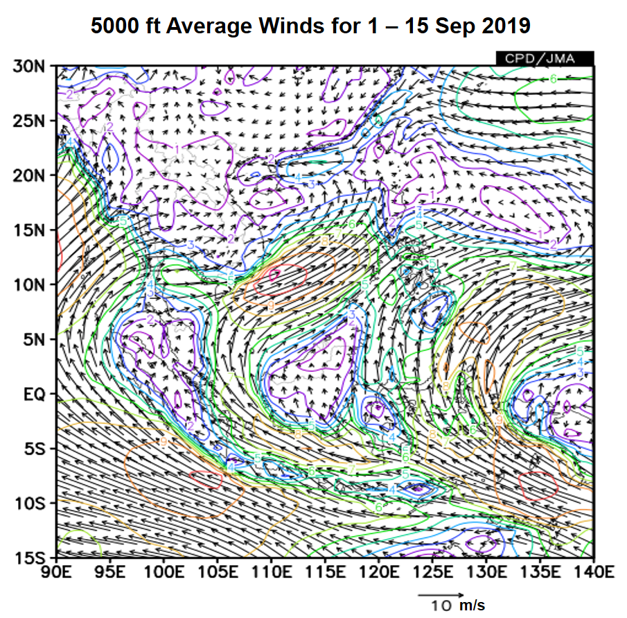
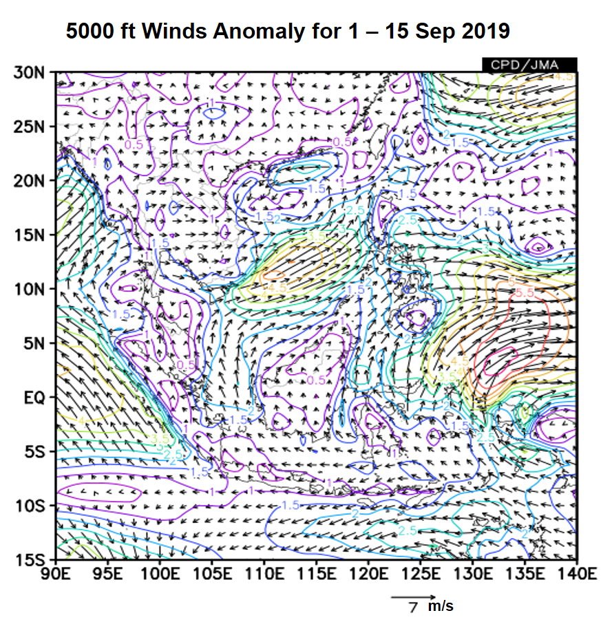
Figure 1: 5000 ft average winds (left) and anomalies (right) for 1 – 15 September 2019 (Source: JMA)
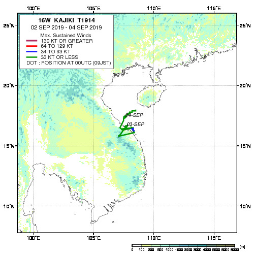
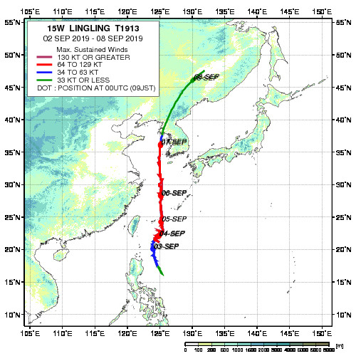
Figure 2: Historical track of Tropical Storm Kajiki (left) and Typhoon Lingling (right). (Source: JAXA)
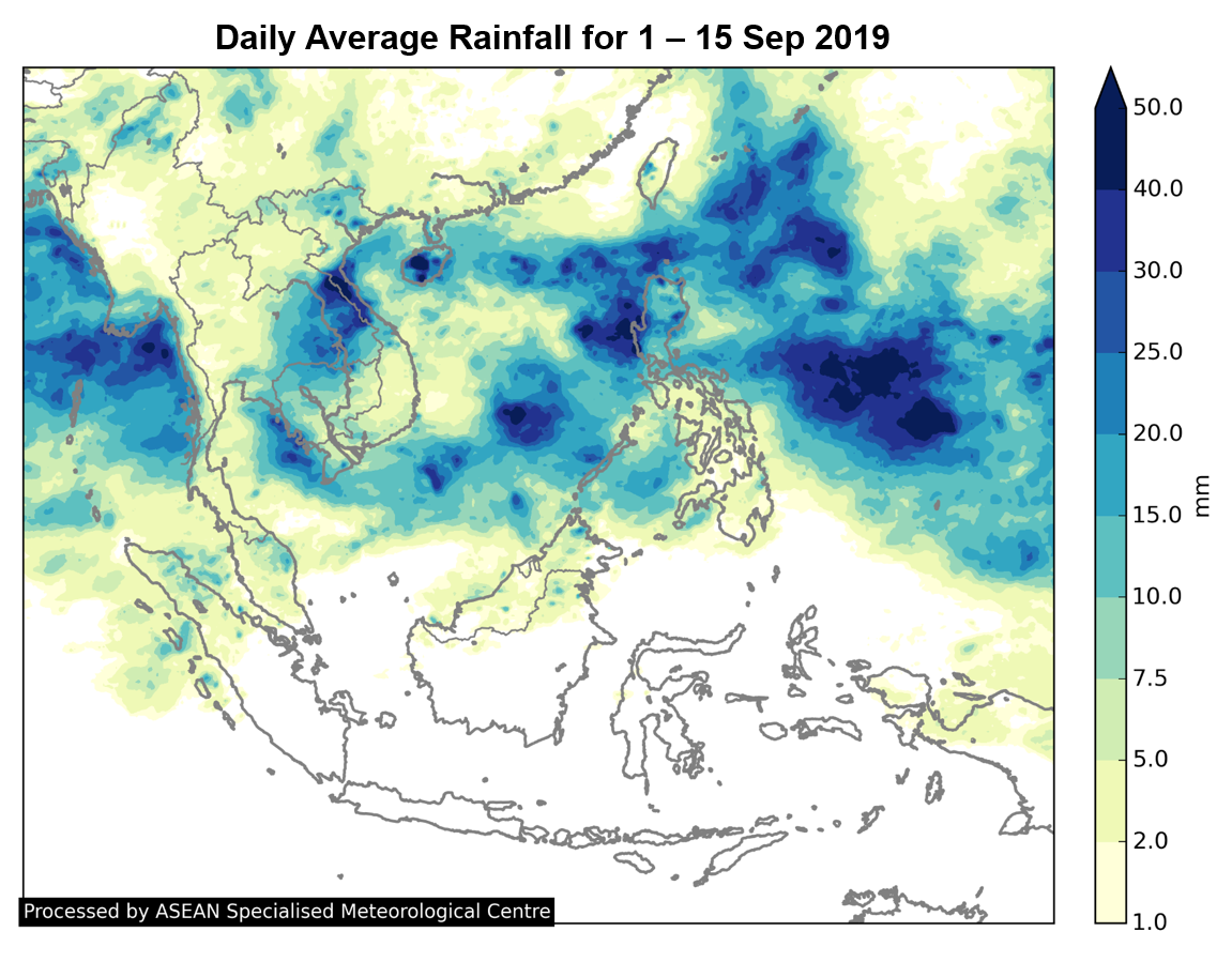
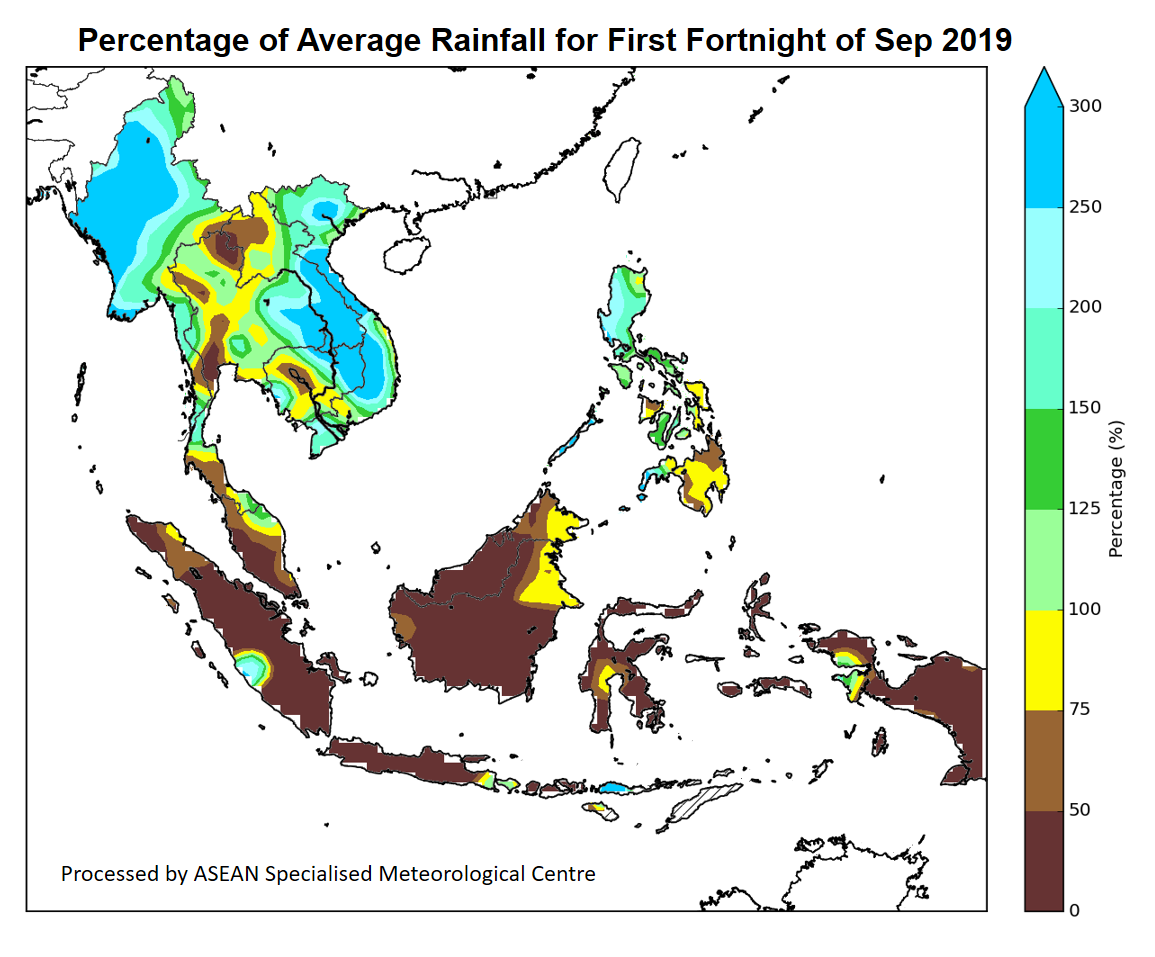
1.2 Southwest Monsoon conditions prevailed in the first half of September 2019. Much of the northern ASEAN region received above-average rainfall except for some areas in Cambodia and Thailand. In the southern ASEAN region, below-average rainfall was observed over many areas (Figures 3 and 4).
1.3 Throughout the first fortnight of September 2019, the Madden-Julian Oscillation (MJO) remained weak based on the RMM index and did not significantly influence the weather over the ASEAN region (Figure 5).
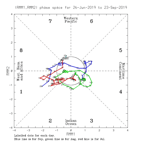
Figure 5: The MJO phase diagram for Sep 2019 (blue). The diagram illustrates the movement of the MJO through different phases, which correspond to different locations along the equator. The distance of the index from the centre of the diagram is correlated with the strength of MJO. When the index falls within the circle, the MJO is considered weak or indiscernible. (Source: Bureau of Meteorology)
1.4 The state of the El Niño-Southern Oscillation (ENSO) is currently neutral (neither El Niño nor La Niña), and the sea-surface temperatures (SST) over the tropical Pacific Ocean continue to show a cooling trend. An Indian Ocean-related index, known as the Indian Ocean Dipole (IOD), is observed to be in the positive phase, as colder-than-average sea surface temperatures continue to be present over the eastern Indian Ocean. The positive IOD has contributed to the drier conditions over the southern ASEAN region during the first fortnight of September 2019.
September 20, 2019
Review of Regional Weather Conditions for Second Fortnight of August 2019
Review of Regional Weather Conditions for Second Fortnight of August 2019
1. Review of Regional Weather Conditions for Second Fortnight of August 2019
1.1 Southwest Monsoon conditions prevailed. There were anomalously strong southwesterly winds over the northern ASEAN region in the second fortnight of August 2019. In the southern ASEAN region, winds were blowing mainly from the southeast.


Figure 1: 5000 ft average winds (left) and anomalies (right) for 16 – 31 August 2019 (Source: JMA)
1.2 In the second half of August 2019, rainfall was generally above average, except in Cambodia, and the southern parts of Thailand and Viet Nam. Tropical Storm Podul, which formed over the Western Pacific Ocean, made landfall in Luzon, the Philippines on 28 August 2019 before tracking westward across the South China Sea. Tropical Storm Podul weakened rapidly after making landfall at northern Viet Nam on 30 August 2019, and the storm contributed to stronger monsoon winds and above-average rainfall over the Mekong sub-region and the Philippines.

Figure 2: Historical track of Tropical Storm Podul. (Source: JAXA)
1.3 In the southern ASEAN region, drier-than-average conditions were observed over many parts of Sumatra, west coast of Peninsular Malaysia, eastern Borneo and Java. The drier-than-average conditions could be partly attributed to the presence of Indian Ocean Dipole in the positive phase.


1.4 During the review period, the Madden-Julian Oscillation (MJO) propagated through the Indian Ocean and Western Maritime Continent. Although the signal was not strong (Figure 5), it might have influenced rainfall over parts of the northern ASEAN region.

Figure 5: The MJO phase diagram (green for August 2019). The diagram illustrates the movement of the MJO through different phases, which correspond to different locations along the equator. The distance of the index from the centre of the diagram is correlated with the strength of MJO. When the index falls within the circle, the MJO is considered weak or indiscernible. (Source: Bureau of Meteorology)
August 27, 2019
Review of Regional Weather Conditions for First Fortnight of August 2019
Review of Regional Weather Conditions for First Fortnight of August 2019
1. Review of Regional Weather Conditions for First Fortnight of August 2019
1.1 Southwest Monsoon conditions prevailed in the first half of August 2019. In the northern ASEAN region, the prevailing winds were blowing mostly from the southwest or west. During the fortnight, the westerly winds were anomalously strong and stronger-than-usual winds were also observed over the Philippines. The stronger winds could have been due to the presence of Tropical Storm Wipha over the South China Sea in early August 2019 and Typhoon Lekima over the western Pacific Ocean from 4 August till 12 August 2019. Wipha made landfall in northern Viet Nam on 3 August, bringing heavy rain and flash floods to the area. The rainband associated with the storms contributed to the well above-average rainfall recorded over northern Philippines and many parts of the Mekong sub-region.
1.2 In the southern ASEAN region, winds were blowing mainly from the southeast or southwest. The dry conditions observed since July 2019 persisted into the first half of August 2019. Well below-average rainfall was observed over many areas. The dry conditions could be attributed partly to the presence of the Indian Ocean Dipole (IOD) in the positive phase.

Figure 1: 5000 ft average winds (left) and anomalies (right) for 1 – 15 August 2019 (Source: JMA)


1.3 There were signs of the Madden-Julian Oscillation (MJO) appearing briefly in Phases 3 and 4 (6th – 11th August), although MJO activity was insignificant by the end of the fortnight. The enhanced shower activities in the northern ASEAN region were consistent with the typical rainfall response from MJO in Phases 3 and 4 during this period.

Figure 4: The MJO phase diagram (blue for August 2019). The diagram illustrates the movement of the MJO through different phases, which correspond to different locations along the equator. The distance of the index from the centre of the diagram is correlated with the strength of MJO. When the index falls within the circle, the MJO is considered weak or indiscernible. (Source: Bureau of Meteorology)
1.4 In the first fortnight of August 2019, the El Niño – Southern Oscillation (ENSO) remained neutral (i.e neither El Niño nor La Niña conditions).
August 10, 2019
Review of Regional Weather Conditions for Second Fortnight of July 2019
Review of Regional Weather Conditions for Second Fortnight of July 2019
1. Review of Regional Weather Conditions for Second Fortnight of July 2019
1.1 Southwest Monsoon conditions continued to prevail in the second half of July 2019. The prevailing winds over the ASEAN region were blowing mainly from the southeast or southwest. During this period, rain bands associated with Tropical Storm Danas and Tropical Storm Wipha, which developed over the Philippine Sea and the South China Sea respectively, brought rainy weather to the northern ASEAN region. Above average rainfall was recorded in some parts of the northern ASEAN region.
1.2 In the southern ASEAN region, drier-than-normal conditions persisted over Peninsular Malaysia, Sumatra, Java and parts of Kalimantan. These conditions could be partly attributed to the presence of the Indian Ocean Dipole (IOD) which is currently in its positive phase.


Figure 1: 5000 ft average winds (left) and anomalies (right) for 16 – 31 July 2019 (Source: JMA)

Figure 2: Tracks of Tropical Storm Danas and Tropical Storm Wipha


1.3 The Madden-Julian Oscillation (MJO) was in Phase 1 and became insignificant towards the last week of the month. The MJO did not have a significant impact on the weather over the region during the past fortnight.

Figure 5: The MJO phase diagram (green for July 2019). The diagram illustrates the movement of the MJO through different phases, which correspond to different locations along the equator. The distance of the index from the centre of the diagram is correlated with the strength of MJO. When the index falls within the circle, the MJO is considered weak or indiscernible. (Source: Bureau of Meteorology)
1.4 In the tropical Pacific Ocean, there was further cooling of the surface and there was no significant atmospheric coupling. The El Niño – Southern Oscillation (ENSO) remained neutral in the second half of July 2019.