

Review of Regional Weather for June 2026
1. Overview
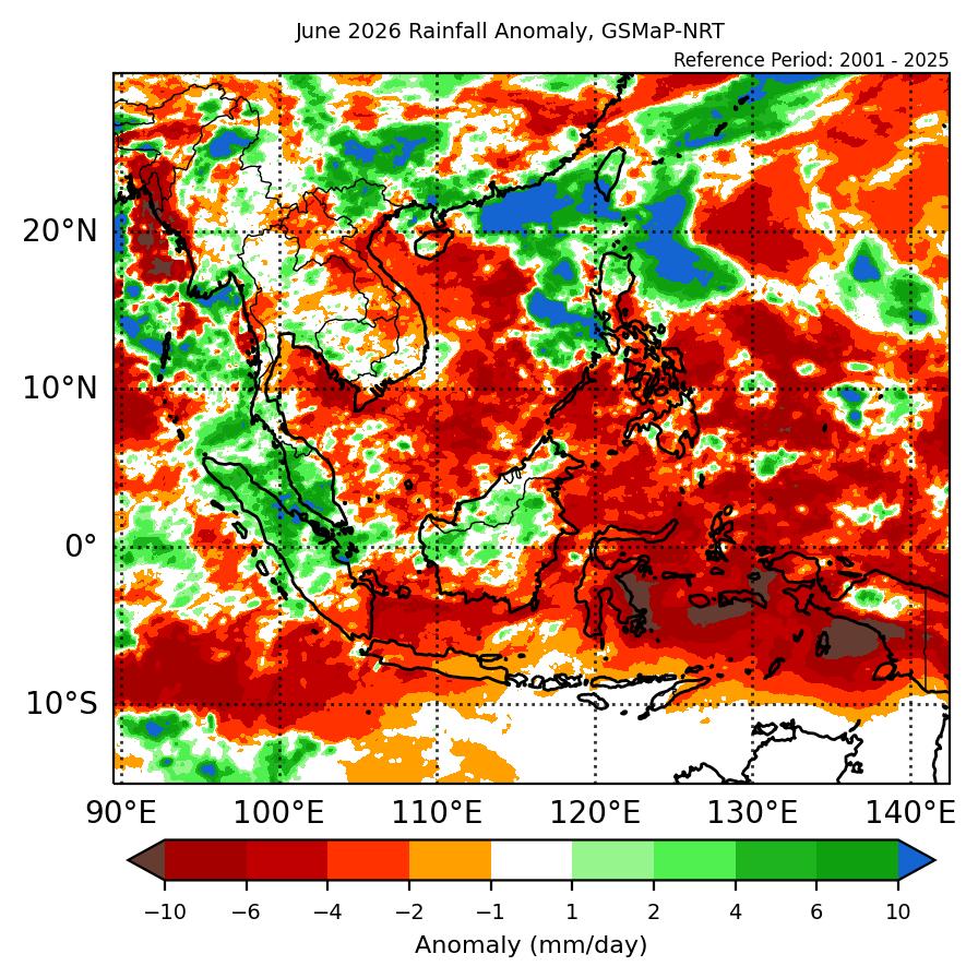
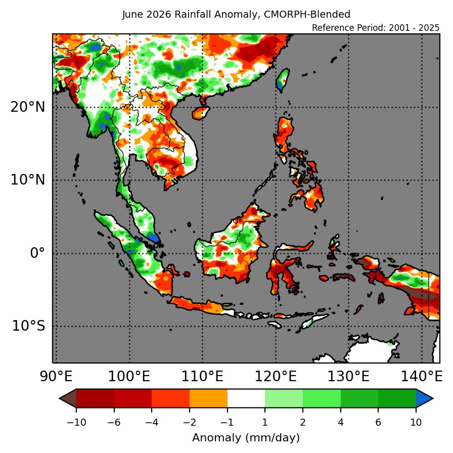
1.1 During June 2026, a mix of near- to above-average rainfall was recorded over the ASEAN region (Figure 1). Parts of southwestern Mainland Southeast Asia recorded above-average rainfall while eastern parts of Mainland Southeast Asia recorded below-average rainfall based on the two datasets (GSMaP-NRT and CMORPH-Blended). The western Maritime Continent recorded mostly above-average rainfall, with most of the southern and eastern region recording below-average rainfall, with a mix of below- to above-average rainfall over the central Maritime Continent. The largest positive (wetter) anomalies were recorded over the southern Malay Peninsula and southern and northern Myanmar, with the largest negative (drier) anomalies over Sulawesi and the Maluku Islands.
1.2 The observed rainfall anomaly pattern of above-average rainfall over southwestern Mainland Southeast Asia and the below-average rainfall over the southern and eastern Maritime Continent are consistent with the predictions from the subseasonal weather outlooks for June 2026 (25 May – 7 June 2026, 8 – 21 June 2026 and 22 June – 5 July 2026). The wet anomalies over southwestern Mainland Southeast Asia and the dry anomalies over the southern and eastern Maritime Continent are consistent with the seasonal outlook for June 2026. However, the seasonal outlook predicted below-normal rainfall as the dominant tercile for the western Maritime Continent for June 2026.
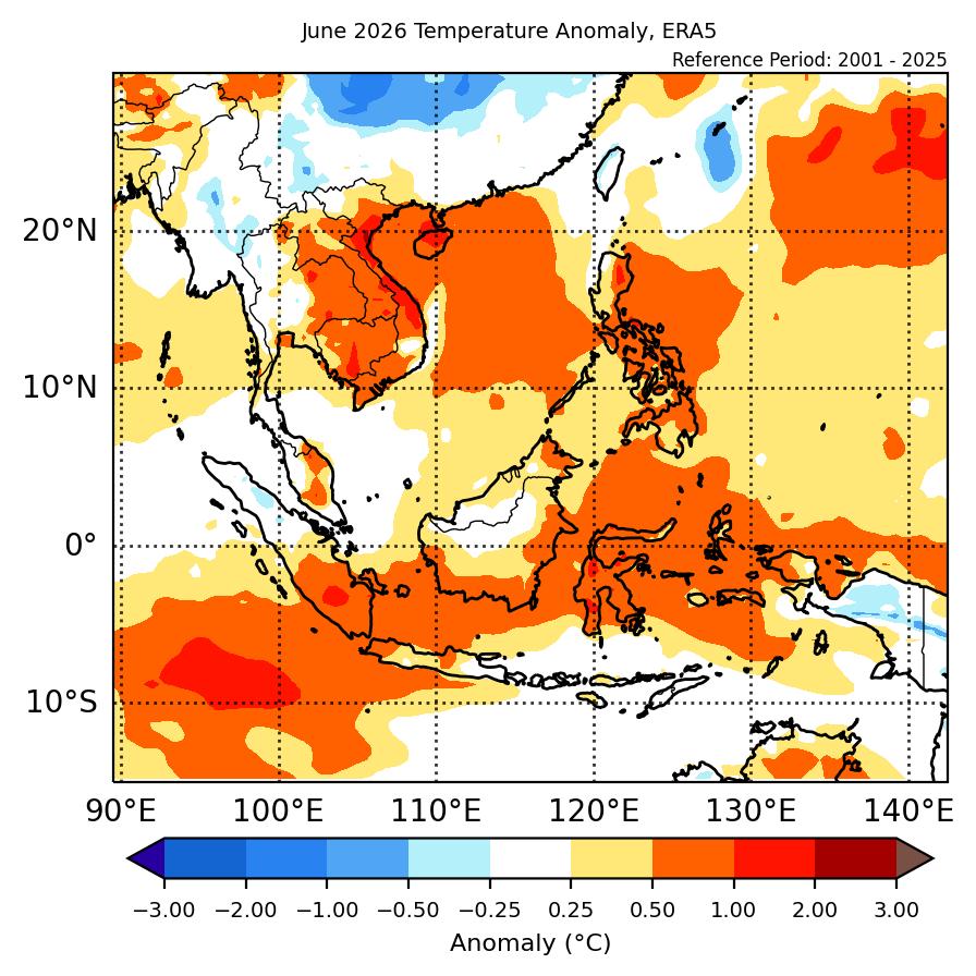
1.3 Above-average temperature was recorded over the eastern half of Mainland Southeast Asia, with near-average temperature elsewhere (Figure 2). Above-average temperature was recorded for much of the Maritime Continent. The warmest anomalies (1°C – 2°C above average) were recorded over parts of central Viet Nam. The coolest anomalies (-0.25°C – -0.5°C below average) were recorded over parts of central Myanmar and Papua.
2. Climate Drivers
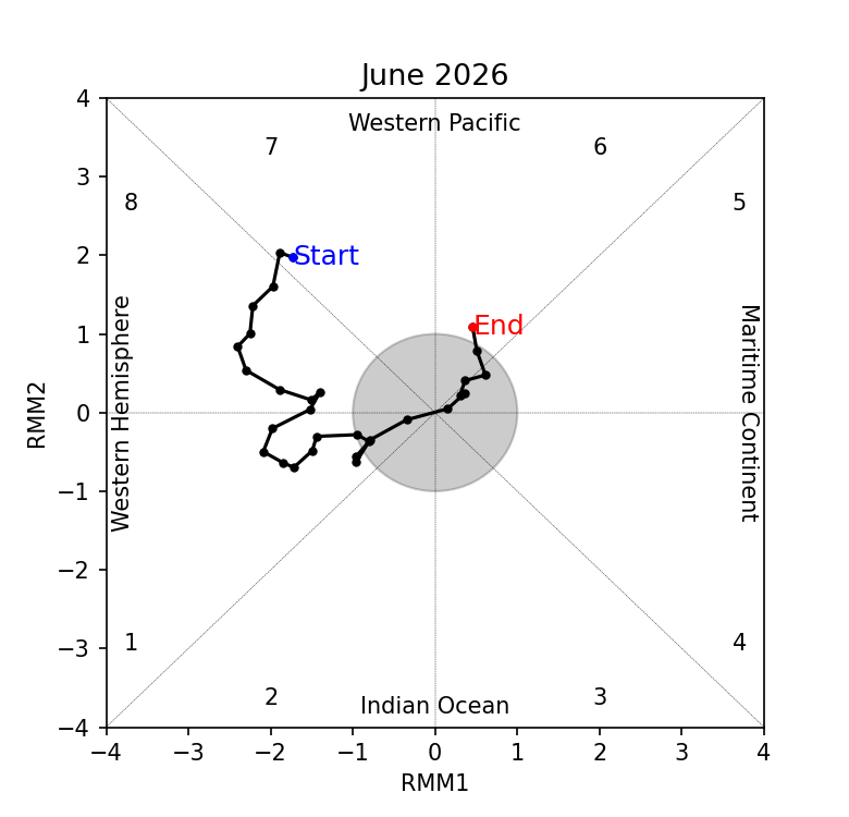
2.1 The Madden-Julian Oscillation (MJO) was active over the Western Hemisphere during much of June 2026. In Week 1, an MJO signal propagated eastwards from the Western Pacific (Phase 7) to the Western Hemisphere (Phase 8). The MJO signal continued propagating eastwards in the western Hemisphere (Phases 8 and 1) in Week 2, before decaying in Week 3 and becoming inactive by the end of the third week of the month. An MJO signal then emerged over the Western Pacific (Phase 6) at the end of June. Phase 8 tends to bring drier conditions to much of the ASEAN region, with Phase 1 can increase rainfall over parts of the western and central equatorial region, while reducing the likelihood of rainfall over much of the rest of the ASEAN region. This is somewhat in drier conditions over the eastern Maritime Continent and wetter conditions in western Maritime Continent in Figure 1.
2.2 The El Niño conditions are now present in June 2026, with the Indian Ocean Dipole (IOD) in the neutral state. El Niño conditions can bring drier conditions to the Maritime Continent at this time of the year.