

Review of Regional Weather for September 2026
1. Overview
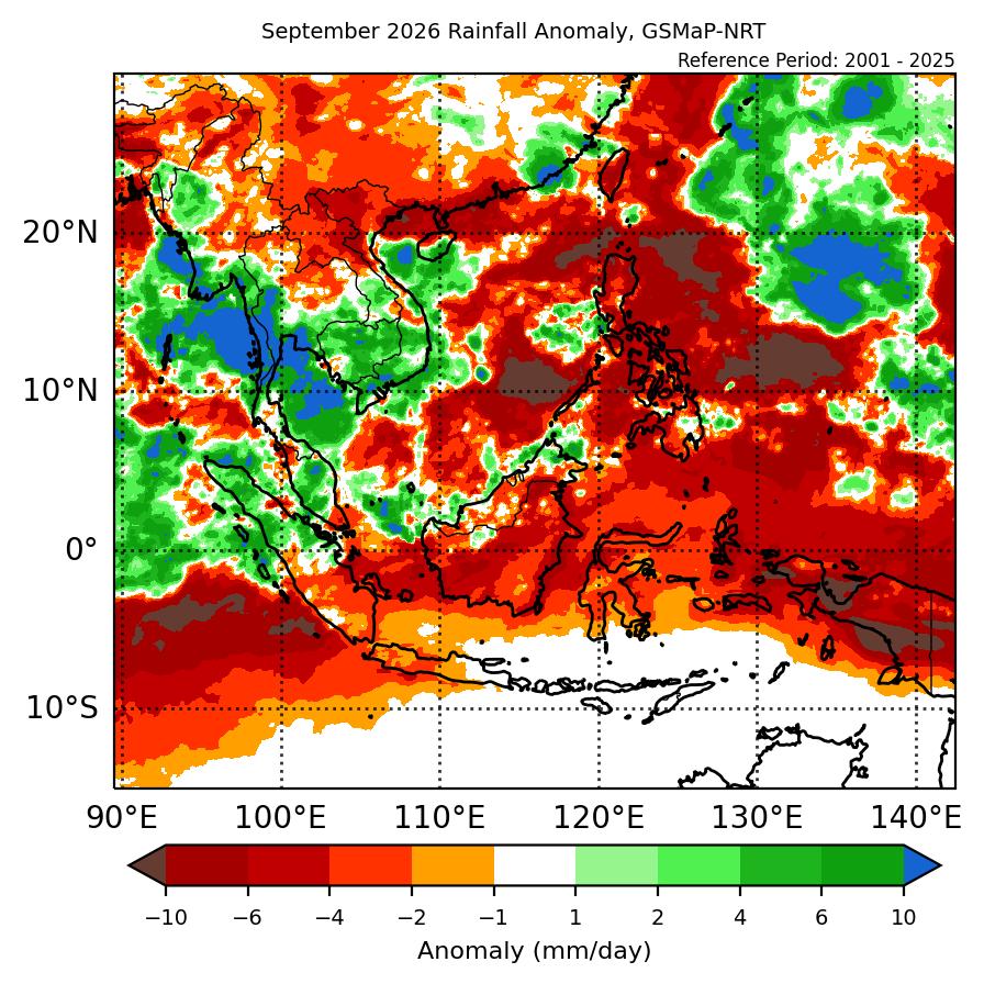
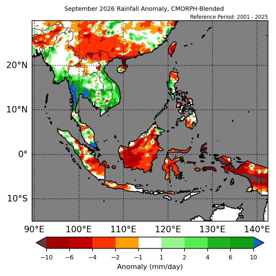
1.1 During September 2026, the Maritime Continent recorded generally below-average rainfall, while Mainland Southeast Asia recorded a mix of below- and above-average rainfall (Figure 1). The largest positive (wettest) anomalies were recorded over southern Thailand and southern Myanmar (both in GSMaP-NRT and CMORPH-Blended datasets). The largest negative (drier) anomalies were recorded over southern Borneo and southern Papua. For Mainland Southeast Asia, the southern and central part recorded predominantly above-normal rainfall, with below-normal rainfall over northern parts. However, there were some differences between the datasets, particularly over the northern parts where GSMaP-NRT recorded drier conditions over most of the region, while CMORPH-Blended recorded drier conditions mostly over northern Viet Nam.
1.2 The observed rainfall anomaly pattern of above-average rainfall over parts of Mainland Southeast Asia and below-average rainfall over most of the Maritime Continent is consistent with the predictions from the subseasonal weather outlooks for September 2026 (31 August – 13 September 2026 and 14 – 27 September 2026). The observations are also partly consistent with the seasonal outlook for September 2026, which predicted below normal rainfall over most of the Maritime Continent, but did not predict wetter conditions for southern Mainland Southeast Asia.
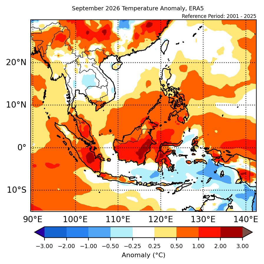
1.3 Most of the southern ASEAN region experienced above-average temperature, while much of the northern ASEAN region experienced near-average temperature (Figure 2). The warmest anomalies (2°C – 3°C above average) occurred over parts of southeastern Borneo, Sulawesi and southern Sumatra. Small negative (cool) anomalies were only recorded in isolated areas in Mainland Southeast Asia.
2. Climate Drivers
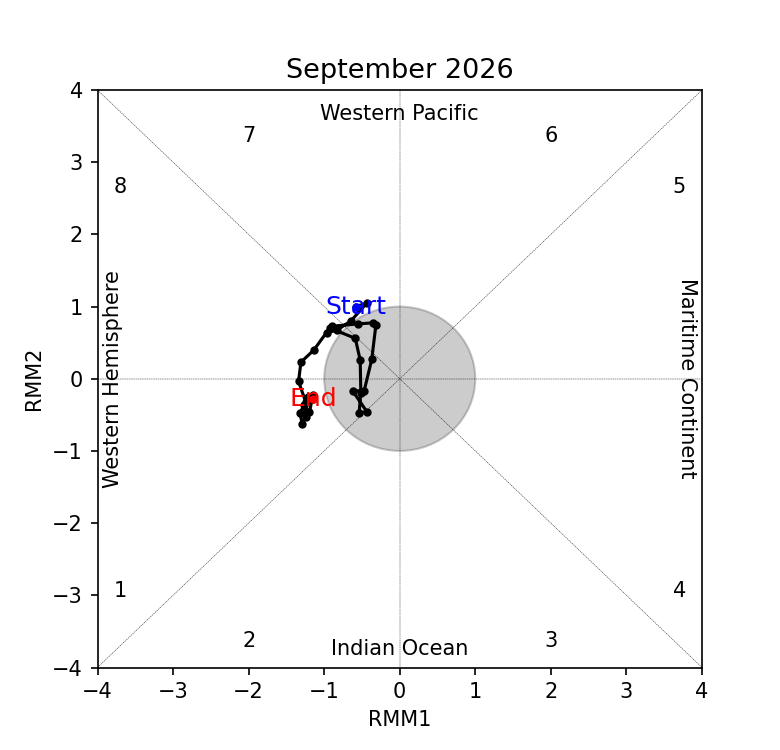
2.1 The Madden-Julian Oscillation (MJO) signal was present over the Western Pacific (Phase 7) in the beginning of September 2026 based on the RMM, this signal briefly propagated eastwards before becoming inactive by the end of the week. Another MJO signal emerged during the third week of September over the Western Hemisphere (Phase 8) and then propagated eastward to Phase 1, before stalling in the last week of the month without further coherent eastward propagation. Phases 7 and 8 typically bring drier conditions to most of the Maritime Continent and parts of Mainland Southeast Asia, while Phase 1 brings drier conditions to central Maritime Continent, Mainland Southeast Asia and the Philippines. This is in line with drier conditions over most of the Maritime Continent, although not the wetter conditions over parts of Mainland Southeast Asia. The ongoing El Niño also likely played a more dominant role.
2.2 The El Niño conditions were present in September 2026, with the Relative Nino3.4 index supporting the strength of the El Niño to be strong. El Niño conditions typically bring drier conditions to most of the Maritime Continent at this time of the year, in line with the drier conditions observed in Figure 1.