Monthly Archives: October 2021

October 29, 2021

Subseasonal Weather Outlook (1 – 14 November 2021)

Subseasonal Weather Outlook (1 – 14 November 2021)

Issued 29 October 2021
First forecast week: 1 November – 7 November
Second forecast week: 8 November – 14 November

figure1

Figure 1: Rainfall Outlook

figure2

Figure 2: Temperature Outlook


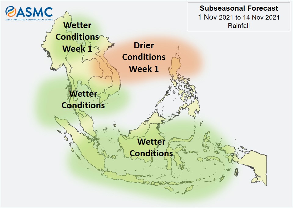
Over most of the southern ASEAN region, wetter conditions are predicted in the next fortnight (1 – 14 November). There is also an increased chance of wetter conditions in the region around 10°N (southern parts of Thailand, Cambodia, and Viet Nam), although with a lower likelihood than for the southern ASEAN region.

In Week 1 (1 – 7 November), wetter conditions are predicted over parts of northern Mainland Southeast Asia (parts of Myanmar and northern Lao PDR). Also in Week 1, drier conditions are predicted over eastern Mainland Southeast Asia and northern Philippines.

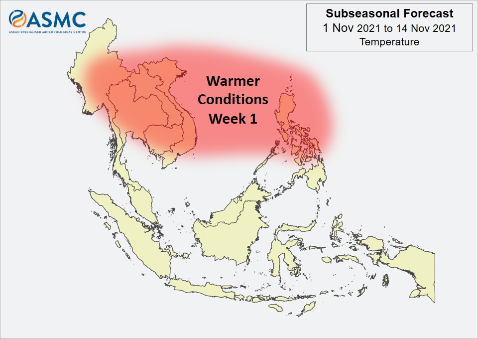
Warmer than usual temperature is predicted over much of the northern ASEAN region in Week 1 (1 – 7 November). These warmer conditions are expected to ease in Week 2 (8 – 14 November), apart from over Myanmar and northern Philippines.

No clear MJO signal was present at the end of October based on the RMM Index.
Most models predict no clear MJO signal for the start of the forecast period, although some models suggest an MJO signal to develop over the Indian Ocean (Phases 2 and 3) in Week 1 and then propagate eastwards over the Maritime Continent (Phases 4 and 5) in Week 2.

 
The outlook is assessed for the region in general, where conditions are relative to the average conditions for the corresponding time of year. For specific updates on the national scale, the relevant ASEAN National Meteorological and Hydrological Services should be consulted.

October 18, 2021

Alert20211018 – End of Dry Season for the Southern ASEAN Region

End of Dry Season for the Southern ASEAN Region

In the past week, shower activities have increased over the southern ASEAN region. Based on surveillance by NOAA-20 satellite, a total of 32 and 3 hotspots were detected in Sumatra, while 10 and 0 hotspots were detected in Kalimantan on 16 and 17 Oct 2021 respectively.

In the coming days, the winds are forecast to be light and variable, signalling the onset of inter-monsoon conditions. Increased shower activities are also expected. With some chance of La Niña conditions developing over the next few months, above-normal rainfall is expected for most parts of the southern ASEAN region for the rest of the year which would help subdue the hotspot activities. Isolated hotspots and localised smoke plumes may however still occur during brief periods of dry weather.

October 15, 2021

Subseasonal Weather Outlook (18 – 31 October 2021)

Subseasonal Weather Outlook (18 – 31 October 2021)

Issued 15 October 2021
First forecast week: 18 October – 24 October
Second forecast week: 25 October – 31 October

figure1

Figure 1: Rainfall Outlook

figure2

Figure 2: Temperature Outlook


Over most of the Maritime Continent, wetter conditions are predicted in the next fortnight (18 – 31 October). The highest likelihood for wetter conditions is for the equatorial region in Week 1 (18 – 24 October), while the highest likelihood is over central and eastern parts of the Maritime Continent in Week 2 (25 – 31 October).

Over Mainland Southeast Asia in Week 1 (18 – 24 October), wetter conditions are predicted apart from over western Mainland Southeast Asia. In Week 2 (25 – 31 October), these wetter conditions are generally expected to ease, although a small increase in wetter conditions remains over southern Mainland Southeast Asia.

No significant regional temperature anomalies are expected in the next fortnight (18 – 31 October).

A Madden-Julian Oscillation (MJO) signal propagated eastward from the Maritime Continent (Phases 4 and 5) towards the Western Pacific (Phase 6) in the first two weeks of October. However, most models predict this signal to decay, with no significant MJO activity during the outlook period.
 
The outlook is assessed for the region in general, where conditions are relative to the average conditions for the corresponding time of year. For specific updates on the national scale, the relevant ASEAN National Meteorological and Hydrological Services should be consulted.

October 13, 2021

Review of Regional Weather for September 2021

Review of Regional Weather for September 2021

1. Overview

1.1 During September 2021, there was above-average rainfall recorded over much of the ASEAN region (Figure 1). The exceptions were northern Sumatra and northern Philippines, and also parts of northern Myanmar, Peninsular Malaysia, Borneo, and Papua, which received a mix of below- to near-average rainfall. The largest positive anomalies (wetter conditions) were recorded over eastern Mainland Southeast Asia (due to Tropical Storm Conson and Tropical Storm Dianmu which made landfall in early-September and late-September respectively) and southern Myanmar for both satellite-derived rainfall estimates datasets (GSMaP-NRT and CMORPH-Blended), with GSMaP-NRT also recording larger anomalies over eastern Borneo, northern and eastern Sulawesi, and Maluku Islands.

1.2 The observed rainfall anomaly pattern of above-average rainfall for much of the ASEAN region is broadly consistent with the predictions from the subseasonal weather outlooks for September 2021 (23 August – 5 September, 6 – 19 September and 20 September – 3 October).

era5_rainfall_anomalies
cmorph_bld_rainfall_anomalies
Figure 1: Rainfall anomalies for the month of September 2021 based on GSMaP-NRT data (left) and CMORPH-Blended data (right). The climatological reference period is 2001-2020. Green colour denotes above-average rainfall (wetter), while orange denotes below-average rainfall (drier).


1.3 Most of the ASEAN region experienced below to near-average temperatures during September 2021 (Figure 2), in line with the wetter conditions recorded. The exceptions were warmer-than-average temperatures recorded over the southeastern Maritime Continent and northern Myanmar.

era5_temperature_anomalies


Figure 2: Temperature anomalies for the month of September 2021 based on ERA-5 reanalysis. The climatological reference period is 2001-2020. Red colour denotes above-average temperature (warmer), while blue denotes below-average temperature (colder).


2. Climate Drivers

2.1 The Madden-Julian Oscillation (MJO, Figure 3) signal over the Indian Ocean (Phase 3) appeared incoherent for most of September 2021 due to interference with other tropical waves. In the last week of September, an MJO signal emerged over the Maritime Continent (Phase 4). Phase 3 tends to bring wetter conditions to western Maritime Continent while Phase 4 tends to bring wetter conditions to much of the region at this time of the year.

mjo_phase_diagram


Figure 3: The MJO phase diagram. The diagram illustrates the movement of the MJO through different phases, which correspond to different locations along the equator (denoted in the text with the first day of the month in blue and the last day of the month in red). The distance of the index from the centre of the diagram is related to the strength of the MJO. Values within the grey circle are considered weak or indiscernible (data from the Bureau of Meteorology, Australia).


2.2 In September, there have been some signs of La Niña-like conditions developing in the tropical Pacific. However, atmospheric indicators (OLR and wind anomalies) have not shown consistent La Niña-like conditions yet. A weak negative Indian Ocean Dipole (IOD) was present and at the seasonal timescale, negative IOD events tend to bring wetter conditions to the southern Maritime Continent.

October 7, 2021

Review of Regional Haze Situation for September 2021

Review of Regional Haze Situation for September 2021

1.1 In September 2021, Southwest Monsoon conditions persisted over the ASEAN region as the prevailing winds blew mainly from the southeast or southwest (Figure 1). In particular, there were three tropical cyclones that affected the northern ASEAN region during the review period. In the first half of September 2021, Typhoon Chanthu and Tropical Storm Conson contributed to the increased rainfall over northern parts of the Philippines. In the last week of the review period, Tropical Storm Dianmu made landfall over Viet Nam, and widespread showers with gusty winds caused floods and landslides in Viet Nam, Lao PDR and Thailand. For the southern ASEAN region, rainy weather was observed over many areas despite this period of the year being its traditional dry season. Average daily rainfall was highest in Sabah, western Kalimantan, and central Sumatra, while relatively drier conditions were observed over the Java Sea region.

Figure 1: Average Daily Rainfall and Mean Wind for September 2021. (Source: JAXA GsMaP and GFS respectively)


1.2 For the September 2021 review period, hotspot activity in the ASEAN region was generally subdued due to wet weather. Most hotspots in the southern ASEAN region were detected in Kalimantan. Overall, the number of hotspots for the southern ASEAN region were lower or comparable to previous years’ counts (Figure 2). For the northern ASEAN region, a majority of the hotspots were detected in Viet Nam. The hotspot counts in Viet Nam, Lao PDR and Myanmar were slightly elevated compared to the same review period in previous years, while the hotspot counts elsewhere in the northern ASEAN region were lower compared to the same review period in previous years (Figure 3).

Figure 2: Hotspot counts for the southern ASEAN region for the month of September (2017 – 2021). [Note: The hotspot counts from 2019 onwards are based on the NOAA-20 satellite, while those from 2017 – 2018 are based on the Suomi-NPP satellite.]


Figure 3: Hotspot counts for the northern ASEAN region for the month of September (2017 – 2021). [Note: The hotspot counts from 2019 onwards are based on the NOAA-20 satellite, while those from 2017 – 2018 are based on the Suomi-NPP satellite.]


1.3 In September 2021, isolated to scattered hotspots were detected mainly in Viet Nam, Borneo, and southern Sumatra (Figure 4 and 5). On a few days in the month, localized smoke haze was observed to emanate from persistent hotspot clusters in western Kalimantan. Slight smoke plumes were occasionally detected from some of the isolated hotspots in eastern Kalimantan and southern Sumatra. Otherwise, no significant transboundary smoke haze was observed over the ASEAN region during the review period.

Figure 4: Distribution of hotspots detected in September 2021 based on NOAA-20 satellite surveillance.


Figure 5: Maximum fire intensity in September 2021 based on NOAA-20 satellite surveillance.


October 1, 2021

Subseasonal Weather Outlook (4 – 17 October 2021)

Subseasonal Weather Outlook (4 – 17 October 2021)

Issued 1 October 2021
First forecast week: 4 October – 10 October
Second forecast week: 11 October – 17 October

figure1

Figure 1: Rainfall Outlook

figure2

Figure 2: Temperature Outlook


Wetter conditions are expected over much of the northern ASEAN region in the next fortnight (4 – 17 October). In Week 1 (4 – 10 October), wetter conditions are predicted over the Philippines, as well as southern and eastern Mainland Southeast Asia. These wetter conditions are likely to become more widespread in Week 2 (11 – 17 October), covering the Philippines and most of Mainland Southeast Asia, apart from northern Myanmar.

Drier conditions are expected over the western Maritime Continent and parts of Borneo in the next fortnight (4 – 17 October).

Warmer than usual temperatures are predicted over much of the equatorial region in the next fortnight (4 – 17 October), including the region where drier conditions are predicted.

A Madden-Julian Oscillation (MJO) signal appeared to be developing over the Maritime Continent (Phase 4) at the end of September based on the RMM Index. Models predict this signal to propagate eastwards for Week 1 of the forecast period. Some models predict this signal to continue propagating through the Western Pacific (Phases 6 and 7) in Week 2, while others predict the signal to decay in Phase 5.
 
The outlook is assessed for the region in general, where conditions are relative to the average conditions for the corresponding time of year. For specific updates on the national scale, the relevant ASEAN National Meteorological and Hydrological Services should be consulted.