Monthly Archives: December 2021

December 24, 2021

Subseasonal Weather Outlook (27 December 2021 – 9 January 2022)

Subseasonal Weather Outlook (27 December 2021 – 9 January 2022)

 
Issued: 24 December 2021
First forecast week: 27 December – 2 January
Second forecast week: 3 January – 9 January

figure1

Figure 1: Rainfall Outlook

figure2

Figure 2: Temperature Outlook


In Week 1 (27 December – 2 January), wetter conditions are expected over much of the Philippines, northern Borneo and northern Sulawesi. However, these wetter conditions are highly dependent on the tropical cyclone development. Also in Week 1, an increased chance of wetter conditions is predicted over parts of Viet Nam and the Malay Peninsula.

Cooler than usual temperature is expected over much of central and eastern Mainland Southeast Asia in Week 1 (27 December – 2 January) associated with a strengthening of the northeasterly winds, bringing cooler air from the northern Asian landmass. In Week 2 (3 – 9 January), these cooler conditions are expected to ease for much of this area.

Warmer than usual temperature is expected over southeastern parts of the Maritime Continent in Week 1 (27 December – 2 January).

Based on the RMM index, a Madden-Julian Oscillation (MJO) signal was present over the Western Pacific (Phases 6 and 7) in December. Some models predict this signal to continue propagating slowly through the Western Pacific, while others predict the signal to decay in Phase 7.
 
The outlook is assessed for the region in general, where conditions are relative to the average conditions for the corresponding time of year. For specific updates on the national scale, the relevant ASEAN National Meteorological and Hydrological Services should be consulted.

December 16, 2021

Review of Regional Haze Situation for November 2021

Review of Regional Haze Situation for November 2021

1.1 In November 2021, the inter-monsoon conditions gradually made way for the Northeast Monsoon over the ASEAN region. The prevailing low-level winds over the northern ASEAN region blew mostly from the northeast or east while the winds over most parts of the southern ASEAN region were light and variable in direction. Wet weather conditions were observed over most parts of the ASEAN region, except for the northern parts of the Philippines as well as the northern, western and central parts of the Mekong sub-region where conditions were persistently drier. Overall, the observed rainfall amount was higher over the coastal areas of central Viet Nam, the southern parts of Thailand and the coastal areas of northern Peninsular Malaysia (Figure 1). Due to the heavy rainfall, floods affected several southern Thailand and central Viet Nam provinces in November 2021.

Figure 1: Average Daily Rainfall and Mean Wind for November 2021. (Source: JAXA GsMaP and GFS respectively)


1.2 For the November review period, overall hotspot activities were mostly subdued due to the wet conditions over the ASEAN region. The hotspot counts over the region for 2021 were mostly lower or comparable to those in previous years (Figures 2 and 3).

Figure 2: Hotspot counts for the northern ASEAN region for the month of November (2017 – 2021). [Note: The hotspot counts from 2019 onwards are based on the NOAA-20 satellite, while those from 2017 – 2018 are based on the Suomi-NPP satellite.]


Figure 3: Hotspot counts for the southern ASEAN region for the month of November (2017 – 2021). [Note: The hotspot counts from 2019 onwards are based on the NOAA-20 satellite, while those from 2017 – 2018 are based on the Suomi-NPP satellite.]


1.3 During the review period, isolated to scattered hotspots were detected mainly in the Mekong sub-region and central Sumatra. While these hotspots were mostly short-lived, hotspots were relatively more persistent in the southern parts of Myanmar, northern Viet Nam and central Thailand. On most days, no smoke plumes were discernable.

Figure 4: Distribution of hotspots detected in November 2021 based on NOAA-20 satellite surveillance.


Figure 5: Maximum fire intensity in November 2021 based on NOAA-20 satellite surveillance.


December 14, 2021

Review of Regional Weather for November 2021

Review of Regional Weather for November 2021


1. Overview

1.1 During November 2021, a mix of below- to above-average rainfall was recorded over the Maritime Continent, while near-average rainfall was recorded over much of Mainland Southeast Asia, except for above-average rainfall recorded over southern Mainland Southeast Asia (Figure 1). The largest positive anomalies (wetter conditions) were recorded over southern Mainland Southeast Asia for both satellite-derived rainfall estimates datasets (GSMaP-NRT and CMORPH-Blended). The largest negative anomalies (drier conditions) were recorded over central Sumatra and the Philippines, with larger negative anomalies based on CMORPH-Blended data compared to GSMaP-NRT.

1.2 The observed rainfall anomaly pattern of a mix of below- to above-average rainfall for the Maritime Continent and the above-average rainfall for southern Mainland Southeast Asia are broadly consistent with the predictions from the subseasonal weather outlooks for November 2021 (1 – 14 November and 15 – 28 November).

era5_rainfall_anomalies
cmorph_bld_rainfall_anomalies
Figure 1: Rainfall anomalies for the month of November 2021 based on GSMaP-NRT data (left) and CMORPH-Blended data (right). The climatological reference period is 2001-2020. Green colour denotes above-average rainfall (wetter), while orange denotes below-average rainfall (drier).


1.3 Above average temperature was recorded over western Mainland Southeast Asia, the western Maritime Continent, as well as the northern Philippines and eastern Indonesia. Below-average temperature was recorded over northeastern Mainland southeast Asia and southern Indonesia (Figure 2). Elsewhere, near-average temperature was recorded. The largest positive anomalies (warmer temperatures) were over western Myanmar, and largest negative anomalies (cooler temperatures) were over northern Viet Nam and eastern Java.

era5_temperature_anomalies


Figure 2: Temperature anomalies for the month of November 2021 based on ERA-5 reanalysis. The climatological reference period is 2001-2020. Red colour denotes above-average temperature (warmer), while blue denotes below-average temperature (colder).


2. Climate Drivers

2.1 There was no Madden-Julian Oscillation (MJO, Figure 3) present at the start of November 2021, based on the MJO phase diagram below. From second week of November onwards, there were signs of a MJO signal over the Maritime Continent (Phases 4 and 5). However, this signal was not very coherent and likely influenced by the background La Niña conditions. Phases 4 and 5 tend to bring wetter conditions to parts of the ASEAN region around 10°N, while Phase 5 tends to bring drier conditions to the western Maritime Continent.

mjo_phase_diagram


Figure 3: The MJO phase diagram. The diagram illustrates the movement of the MJO through different phases, which correspond to different locations along the equator (denoted in the text with the first day of the month in blue and the last day of the month in red). The distance of the index from the centre of the diagram is related to the strength of the MJO. Values within the grey circle are considered weak or indiscernible (data from the Bureau of Meteorology, Australia).


2.2 La Niña conditions were present over the tropical Pacific. Sea surface temperatures in the Nino3.4 region (used to monitor ENSO) and the atmospheric indicators over the tropical Pacific Ocean were consistent with La Niña conditions. La Niña events tend to bring wetter-than-average conditions to much of Southeast Asia during the September to November period.

December 10, 2021

Subseasonal Weather Outlook (13 – 26 December 2021)

Subseasonal Weather Outlook (13 – 26 December 2021)

Issued 10 December 2021
First forecast week: 13 December – 19 December
Second forecast week: 20 December – 26 December

figure1

Figure 1: Rainfall Outlook

figure2

Figure 2: Temperature Outlook


In Week 1 (13 – 19 December), wetter conditions are expected over central parts of the Philippines and the eastern coastal regions of Mainland Southeast Asia. However, these wetter conditions are highly dependent on the tropical cyclone development. Also in Week 1, wetter conditions are expected over both western and eastern parts of the equatorial region.

Drier conditions are expected over the central equatorial region in Week 2 (20 – 26 December).

Warmer than usual temperature is expected over the southeastern parts of the Maritime Continent in Week 1 (13 – 19 December).

A Madden-Julian Oscillation (MJO) signal propagated eastward from the eastern Maritime Continent (Phase 5) to the Western Pacific (Phases 6 and 7) in the first fortnight of December. However, most models predict this signal to decay in the second week of the forecast period as it propagates eastwards towards Western Hemisphere and Africa (Phase 8).
 
The outlook is assessed for the region in general, where conditions are relative to the average conditions for the corresponding time of year. For specific updates on the national scale, the relevant ASEAN National Meteorological and Hydrological Services should be consulted.


MEDIA RELEASE

START OF DRY SEASON IN THE NORTHERN ASEAN REGION

Singapore, 9 December 2021 – The traditional dry season in the northern ASEAN region has started and is expected to extend into May 2022. The dry season usually sets-in following the Northeast Monsoon, which has become established over the ASEAN region in the past few weeks.

2          The equatorial Pacific Ocean is currently in a La Niña phase, which typically brings more rainfall to parts of the region. For the December 2021 to March 2022 period, near-to-above average rainfall is predicted for many parts of the northern ASEAN region, except for northern parts of Lao PDR, Myanmar and Viet Nam.

3          While this traditional dry season is predicted to experience near-to-above average rainfall over most of the region, fire hotspots and smoke haze could still develop during extended periods of dry and warm weather. During the Northeast Monsoon, the low-level winds in the region typically blow from the northeast or east. Transboundary haze may occur if the winds blow any smoke haze from fires to neighbouring countries. Early precautionary and mitigation measures are advised to prevent the occurrence of transboundary haze in the region.

4          For regular and ad-hoc updates of the regional weather and smoke haze situation and early warnings, please visit the ASMC website at https://asmc.asean.org.

[1] The northern ASEAN region comprises of Cambodia, Lao PDR, Myanmar, the Philippines, Thailand and Viet Nam.

December 7, 2021

Alert20211207 – Start of Dry Season for the Northern ASEAN Region

Start of Dry Season for the Northern ASEAN Region

Dry weather conditions associated with the Northeast Monsoon have prevailed over much of the northern ASEAN region in the past several days, contributing to an increase in hotspot activities. Based on surveillance by the NOAA-20 satellite, a total of 86, 156 and 115 hotspots were detected in Myanmar, Thailand, and Viet Nam, respectively, between 1 and 6 Dec 2021.

The Northeast Monsoon conditions are expected to persist until March 2022, during which extended periods of dry weather may lead to further increases in hotspots activities.

ASMC Media Release – Start of northern ASEAN dry season

December 1, 2021

17th ASEAN COF (Nov 2021, Online)

Seventeenth Session of the ASEAN Climate Outlook Forum (ASEANCOF-17)

image_gallery

22, 23, 24, 26 November 2021, ASEAN Specialised Meteorological Centre
 

Consensus Bulletin for December-January-February (DJF) 2021/2022 Season

The ASEAN Climate Outlook Forum (ASEANCOF) is an avenue to collaboratively develop consensus-based seasonal climate outlooks and related information on a regional scale. The forum’s outlook and its activities contribute significantly to one of the key roles of the ASEAN Specialised Meteorological Centre (ASMC), which is to conduct climate and seasonal prediction for the ASEAN region through pooling the expertise of ASEAN National Meteorological and Hydrological Services (NMHSs). In 2021, the ASEANCOF Working Group was established with the goal to guide and support the long-term development of ASEANCOF, in particular with regard to the implementation of objective outlooks.

The seventeenth session of ASEANCOF (ASEANCOF-17) was organised by the ASEAN Specialised Meteorological Centre (ASMC) in conjunction with the ASEANCOF Working Group. Representatives from the NMHSs of ASEAN Member States created a consensus forecast for the boreal winter monsoon 2021/2022 in the ASEAN region. The consensus for December-January-February (DJF) 2021/2022 outlooks was achieved through an online session, which included presentations from NMHSs and Global Producing Centres (GPCs) of seasonal outlooks, questionnaires and discussions regarding the current conditions and predictions for the Southeast Asia region. In particular, the forum considered the possible influence of the El Niño Southern Oscillation (ENSO) and the Indian Ocean Dipole (IOD) on the climate system over Southeast Asia.

image_gallery


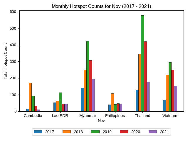
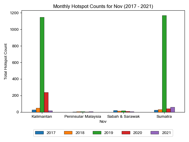
Conditions and Outlook

Recent analyses of sea surface temperature (SST) anomalies over the equatorial Pacific indicated below-average SSTs across most of the central and eastern tropical Pacific Ocean. Most ENSO indicators are now in line with La Niña conditions. The international climate outlooks predict that La Niña conditions are likely to prevail during DJF 2021/2022. The La Niña conditions are expected to be weak to moderate during this time. Conditions are predicted to weaken in boreal spring 2022.

The current Indian Ocean Dipole (IOD) state is neutral and is expected to remain neutral for DJF 2021/2022.

The onset of the Northeast Monsoon season is expected to be or has been near-normal for much of the region, although the onset was earlier than normal for Viet Nam. Over much of Southeast Asia, the strength of the Northeast monsoon is expected to be near normal or stronger than normal, based on model predictions and supported by the current La Niña conditions.

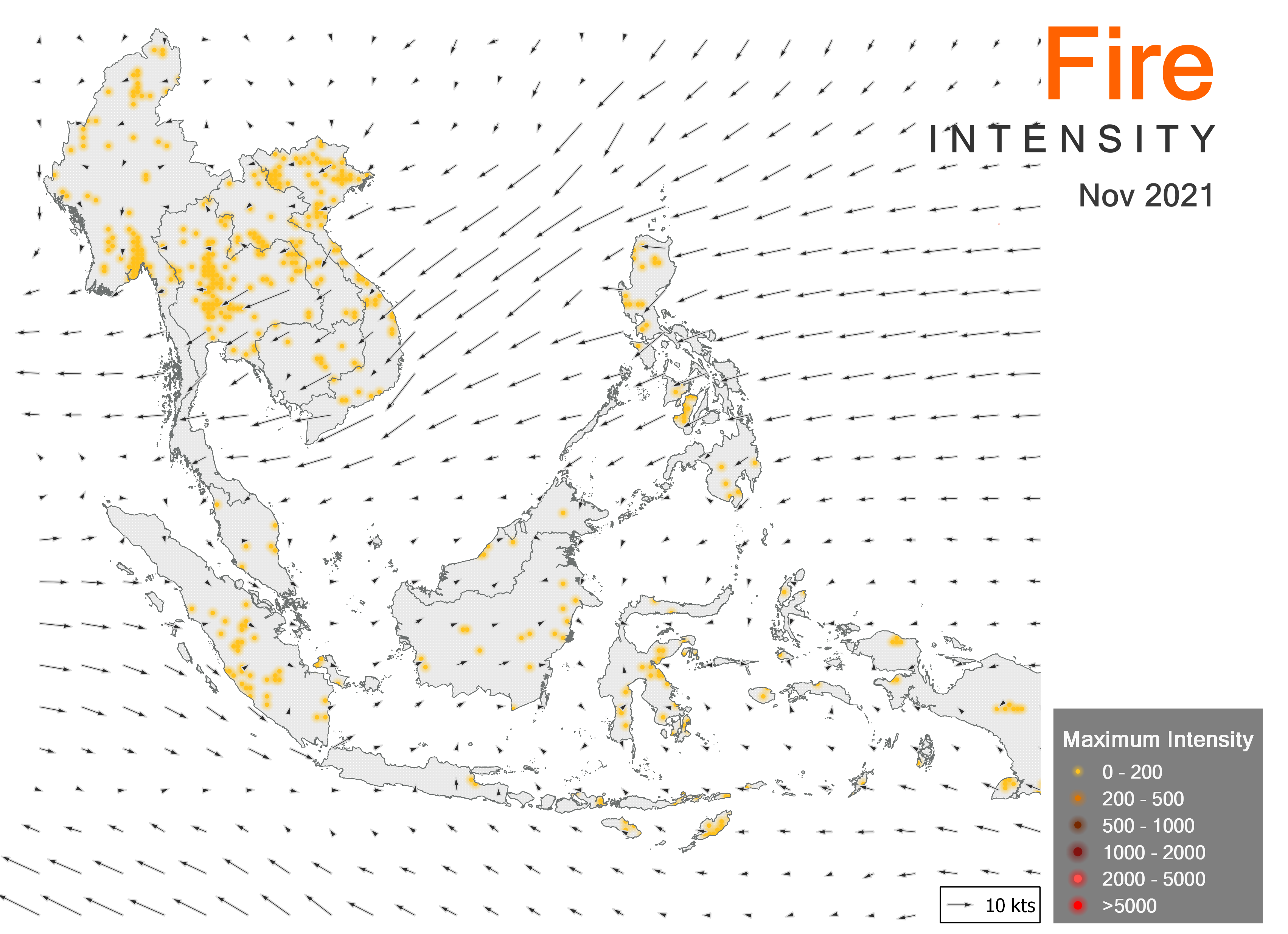
Overall, the tropical cyclone frequency is expected to be above-average for the Bay of Bengal, while near-average around the West Philippine Sea/South China Sea and the Western North Pacific (WNP). This is based on model predictions. During La Niña events, there tends to be more tropical cyclones than average, however, the late onset of the La Niña event as well as its predicted strength means that the increase is not expected to be significant in DJF 2021/2022 for much of the region.

Taking into consideration the national level forecasts, the present state of the climate, and the forecasts available from the GPCs and other global centres, the forum agreed on the following consensus-based outlook for DJF 2021/2022 for the Southeast Asia region:


RAINFALL

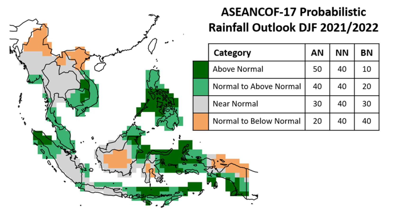
Over much of the Maritime Continent, near- to above-normal rainfall is expected. In particular, above-normal rainfall is predicted for central parts of the Philippines, while near- to above-normal rainfall is predicted over Malaysia, Singapore, and Brunei Darussalam.

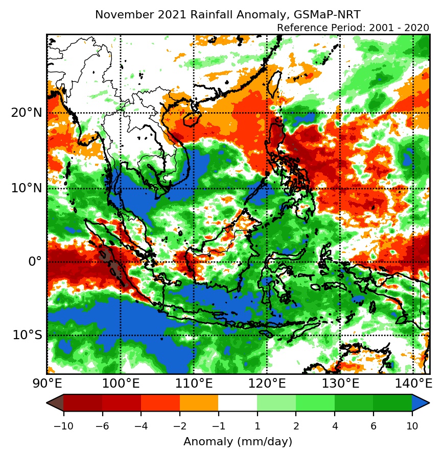
Over Mainland Southeast Asia, a mix of below- to above- normal rainfall is predicted. Below- to near- normal rainfall is predicted over northern Myanmar, northern Lao PDR, and northern Viet Nam. Above-normal rainfall is predicted over southern Lao PDR, while near- to above-normal rainfall is predicted over parts of southern Myanmar, southern Thailand, parts of Cambodia, and southern Viet Nam. Elsewhere in Mainland Southeast Asia rainfall is predicted to be near-normal.

TEMPERATURE

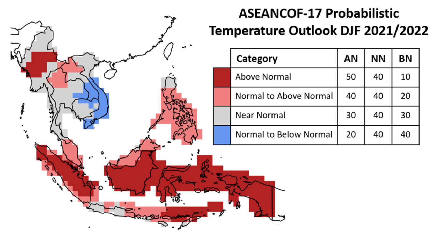
Over much of the Maritime Continent, near- to above-normal temperature is predicted. Near-normal temperature is predicted for Brunei Darussalam and northern Philippines, with near- to above-normal and above-normal temperature predicted elsewhere.

For Mainland Southeast Asia, a mix of below- to above-normal temperatures are predicted. The highest likelihood of below-normal temperature is over southern Lao PDR and southern Viet Nam. The highest likelihood of above-normal temperature is over central Myanmar, followed by northern Thailand and northern Lao PDR.

Refer to Annex A for reference on what is meant by “above, near, or below normal” in the outlook. For more information on the boreal (Northern Hemisphere) winter monsoon outlook and further updates on the national scale, the relevant NMHSs should be consulted (see Annex B).
 

Consensus Maps for DJF 2021/2022 Season

The following maps provide the probabilistic outlooks for DJF 2021/2022 season in terms of tercile categories of “Above Normal” (AN: upper tercile), “Near Normal (NN: middle tercile) and “Below Normal” (BN: lower tercile).
 

PROBABILISTIC RAINFALL OUTLOOK

image007

PROBABILISTIC TEMPERATURE OUTLOOK

image008
 

Meeting Documents

ASEANCOF-17 Outlook Bulletin
 

Acknowledgements

The Forum would like to convey its appreciation to the National Meteorological Services of the ASEAN Member States for sharing their national-level forecasts, the Global Producing Centres, the Southeast Asia Regional Climate Centre – Network, and other partners of ASEANCOF for sharing their products and expertise, and WMO for their continued support of ASEANCOF.