Monthly Archives: May 2025

May 21, 2025

Subseasonal Weather Outlook (26 May – 8 June 2025)

Subseasonal Weather Outlook (26 May– 8 June 2025)

Issued: 21 May 2025
First forecast week: 26 May – 1 June 2025
Second forecast week: 2 – 8 June 2025

figure1

Figure 1: Rainfall Outlook

figure2

Figure 2: Temperature Outlook

For western and central Mainland Southeast Asia, wetter conditions are predicted in Week 1 (26 May – 1 June). For the same region in Week 2 (2 – 8 June), drier than usual conditions for this time of the year are predicted.

For the Maritime Continent, drier conditions are predicted over the western and central equatorial region in Week 1 (26 May – 1 June). Wetter conditions are predicted over parts of the southern Maritime Continent in the next fortnight (26 May – 8 June).

Warmer than usual temperatures are predicted over much of the equatorial region in the next fortnight (26 May – 8 June). Warmer than usual temperatures are also predicted over the northeastern parts of Mainland Southeast Asia in Week 2 (2 – 8 June).

There has been no discernible Madden-Julian Oscillation (MJO) signal so far this month. Most models predict no MJO activity during the forecast period.

The outlook is assessed for the region in general, where conditions are relative to the average conditions for the corresponding time of year. For specific updates on the national scale, the relevant ASEAN National Meteorological and Hydrological Services should be consulted.

Alert20250521 – End of Dry Season for the Mekong sub-region

End of Dry Season for the Mekong sub-region

The persistent wet weather over the Mekong sub-region in recent days has continued to suppress the overall hotspots and smoke haze situation in the sub-region. Based on the NOAA-20 satellite surveillance, a total of 7 and 27 hotspots were detected in the Mekong sub-region on 19 and 20 May 2025 respectively.

In the coming months, shower activities are forecast to continue, which should keep the hotspot and smoke haze situation subdued over the Mekong sub-region.

May 16, 2025

Review of Regional Weather for April 2025

Review of Regional Weather for April 2025


1. Overview

1.1 During April 2025, much of the western Maritime Continent and western Mainland Southeast Asia experienced above-average rainfall, while much of the southern and northeastern Maritime Continent experienced below-average rainfall (Figure 1). The largest positive (wetter) anomalies were recorded over the Malay Peninsula. Outside of the regions mentioned above, there was either disagreements between GSMaP-NRT and CMORPH-Blended datasets or no notable anomalies. For much of the central and eastern equatorial region CMORPH-Blended recorded below-average rainfall, while GSMaP-NRT recorded above-average rainfall. CMORH-Blended also recorded below-average rainfall for Cambodia, while GSMaP-NRT was near-average.

1.2 The observed rainfall anomaly pattern of above-average rainfall over much of western Mainland Southeast Asia and the western Maritime Continent and drier conditions over the northeastern Maritime continent is consistent with the predictions from the subseasonal weather outlooks for April 2025 (31 March – 13 April 2025, and 14 – 27 April 2025). The observed pattern is also partly consistent with the April 2025 seasonal outlook of above-normal rainfall over western Mainland Southeast Asia, although the northwestern Maritime Continent was predicted to have a higher chance of above-normal rainfall.

era5_rainfall_anomalies
cmorph_bld_rainfall_anomalies
Figure 1: Rainfall anomalies for April 2025 based on GSMaP-NRT data (left) and CMORPH-Blended data (right). The climatological reference period is 2001-2024. Green colour denotes above-average rainfall (wetter), while orange denotes below-average rainfall (drier).


1.3 Below-average and near-average temperatures were recorded over most of Southeast Asia in April 2025, apart from over northern Myanmar and the Philippines (Figure 2). The coldest anomalies (-1°C – -2°C below average) were recorded over parts of western and southern Myanmar, associated with regions of above-average rainfall. The warmest anomalies (1°C – 2°C above average) were recorded over northern Myanmar.

era5_temperature_anomalies
Figure 2: Temperature anomalies for April 2025 based on ERA-5 reanalysis. The climatological reference period is 2001-2024. Red colour denotes above-average temperature (warmer), while blue denotes below-average temperature (colder).


2. Climate Drivers

2.1 There was no discernible Madden-Julian Oscillation (MJO) signal for most of April based on the RMM diagram (Figure 3). During the last week of April, there were signs of an MJO signal over the Western Pacific (Phases 6 and 7) and the Western Hemisphere (Phase 8). Phases 6 and 8 tend to bring drier conditions to parts of the Maritime Continent at this time of the year, although this is not noticeable in the April rainfall anomalies, particularly for GSMaP-NRT.

mjo_phase_diagram


Figure 3: The MJO phase diagram. The diagram illustrates the movement of the MJO through different phases, which correspond to different locations along the equator (denoted in the text with the first day of the month in blue and the last day of the month in red). The distance of the index from the centre of the diagram is related to the strength of the MJO. Values within the grey circle are considered weak or indiscernible (data from the Bureau of Meteorology, Australia).


2.2 ENSO-neutral conditions were present in April 2025. Sea surface temperatures in the Nino3.4 region (used to monitor ENSO) indicated a return to ENSO-neutral. Key atmospheric indicators of La Niña (reduced cloudiness and stronger trade winds in the central Pacific) were present earlier in March, but have since shown signs of weakening, in line with a transition to ENSO-neutral conditions.


May 13, 2025

Alert20250513 – Downgrade to Alert Level 1 for the Mekong sub-region

Downgrade to Alert Level 1 for the Mekong sub-region

In recent days, there has been an increase in shower activities in the Mekong sub-region, which led to reduced hotspot counts and haze occurrence. With wet weather conditions expected over most areas of the sub-region in the coming days, the chance of transboundary haze has been reduced significantly. Isolated hotspots and localised smoke plumes may still occur over drier areas.

Based on surveillance using the NOAA-20 satellite, a total of 24 and 9 hotspots were detected in the Mekong sub-region on 11 May 2025 and 12 May 2025 respectively. The overall hotspot and smoke haze situation over the sub-region is likely to improve with an expected increase in rainfall.

ASMC Annual Report 2024/2025

ASMC Annual Report 2024/2025

May 9, 2025

24th ASEAN COF (April 2025)

Twenty Fourth Session of the ASEAN Climate Outlook Forum (ASEANCOF-24)

image_gallery

22 – 25 April 2025, MOWRAM Cambodia

Consensus Bulletin for June-July-August (JJA) 2025 Season

The ASEAN Climate Outlook Forum (ASEANCOF) is an avenue to collaboratively develop consensus-based seasonal climate outlooks and related information on a regional scale. The forum’s outlook and its activities contribute significantly to one of the key roles of the ASEAN Specialised Meteorological Centre (ASMC), which is to conduct climate and seasonal prediction for the Association of Southeast Asian Nations (ASEAN) region through pooling the expertise of ASEAN National Meteorological and Hydrological Services (NMHSs). In 2021, the ASEANCOF Working Group was established with the goal to guide and support the long-term development of ASEANCOF, in particular with regard to the implementation of objective outlooks.

The Twenty-Fourth session of ASEANCOF (ASEANCOF-24) was organised by the Ministry of Water Resources and Meteorology, Cambodia (MOWRAM), RIMES, ASMC, the ASEANCOF Working Group, and WMO. A two-day training workshop occurred prior to the COF proper, with training by the UK Met Office, ASMC, and University of Southern Queensland (22 – 23 April).

During the COF proper, participants from the NMHSs of ASEAN Member States created a consensus forecast for the boreal summer monsoon 2025 in the ASEAN region. The consensus for the June-July-August (JJA) 2025 outlook was achieved through a hybrid session, which included presentations from NMHSs, questionnaires, and discussions regarding the current climate conditions and predictions for Southeast Asia. The theme of ASEANCOF-24 was Climate Services and Heat Health. On the last day of ASEANCOF-24, a sharing session was held by the Global Heat Health Information Network (GHHIN) Southeast Asia Hub, followed by a general sharing session by various sector representatives and producers, including UN ESCAP, FAO, and agricultural and health representatives from Lao PDR and Cambodia. A recording of the COF proper is available at https://community.wmo.int/en/meetings/24th-association-southeast-asian-nations-asean-climate-outlook-forum-aseancof-24.

image_gallery


Conditions and Outlook

Recent analysis of sea surface temperature (SST) anomalies over the equatorial Pacific shows average to slightly below-average SSTs across the equatorial Pacific Ocean, and along with atmospheric indicators such as trade wind strength and cloudiness, indicate ENSO-neutral conditions. In the Indian Ocean, the Indian Ocean Dipole (IOD) is neutral.
The international climate outlook predicts that ENSO-neutral conditions will continue into JJA 2025. After JJA 2025, most models predict ENSO-neutral conditions, although there is still a high amount of uncertainty for ENSO predictions issued in April.

The Indian Ocean Dipole (IOD) is also predicted to be neutral during JJA 2025.

The onset of the Southwest monsoon season is predicted to be near average for most of Southeast Asia in 2025, starting from May. The strength of the Southwest monsoon is predicted to be near-average over most of Southeast Asia, based on model predictions.

During JJA 2025, tropical cyclone frequency is predicted to be near average around the Philippine Sea and the South China Sea and above average over the Bay of Bengal.
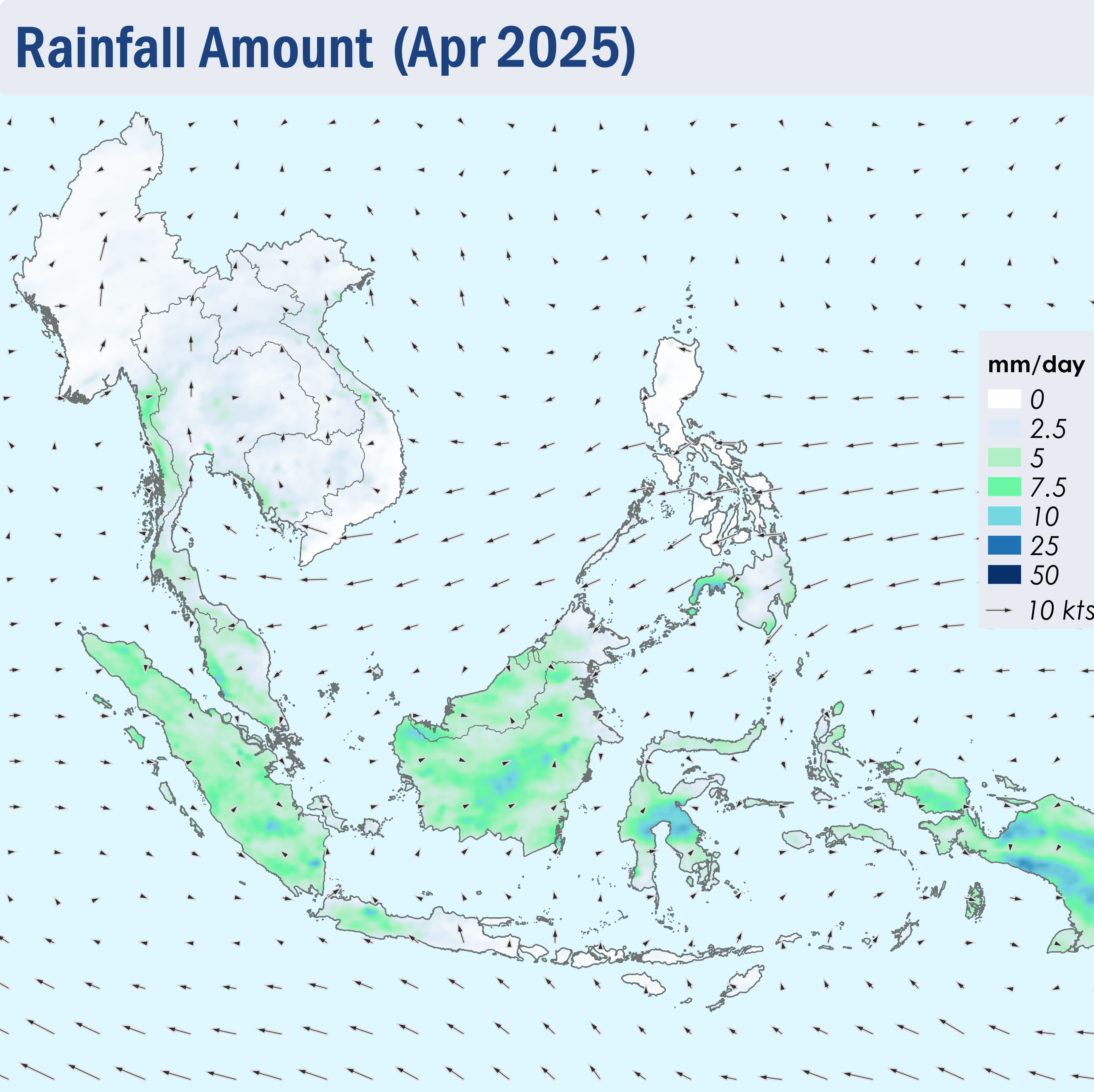
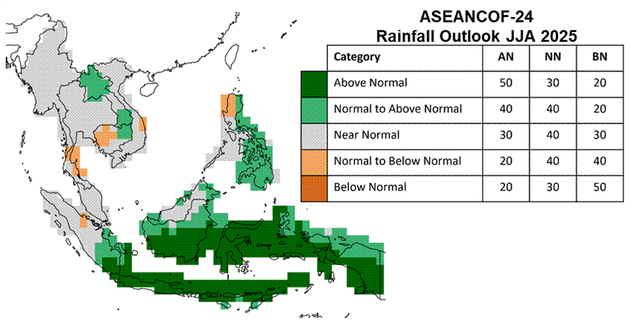
RAINFALL

For the upcoming boreal (Northern Hemisphere) summer season (JJA 2025):
Above-normal rainfall is predicted over parts of the southern ASEAN region. Near- to above-normal rainfall is predicted over eastern and southern Philippines, parts of east Malaysia, Brunei Darussalam, northeastern Cambodia, and northern and southern Lao PDR.

Below- to near-normal rainfall is predicted over parts of southern Thailand, northwestern Cambodia, coastal central Vietnam and northwestern Philippines.

Elsewhere, near-normal rainfall is predicted.
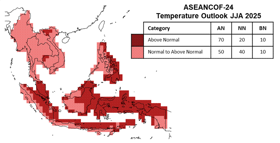
TEMPERATURE

For the upcoming boreal (Northern Hemisphere) summer season (JJA 2025):
Above-normal temperature is predicted over much of the equatorial region, as well as over eastern and southern Philippines and parts of northern Viet Nam and northwestern Cambodia.

Elsewhere, near- to above-normal1 temperature is predicted.

1For this outlook, near-to above-normal temperature corresponds to 50% probability of above-normal temperature, 40% near-normal, and 10% below-normal. Further information is in the consensus maps.

Refer to Annex A for reference on what is meant by “above, near, or below normal” in the outlook. For more information on the boreal (Northern Hemisphere) summer monsoon outlook and further updates on the national scale, the relevant NMHSs should be consulted (see Annex B).

CONSENSUS MAPS FOR JJA 2025

The following maps provide the probabilistic outlooks for JJA 2025 season in terms of tercile categories of “Above Normal” (AN: upper tercile), “Near Normal (NN: middle tercile) and “Below Normal” (BN: lower tercile).

PROBABILISTIC RAINFALL OUTLOOK

image007

PROBABILISTIC TEMPERATURE OUTLOOK

image008

Meeting Documents

ASEANCOF-24 Outlook Bulletin

Acknowledgements

ASEANCOF would like to convey its appreciation to the NMHSs of the ASEAN Member States for sharing their national level forecasts, the Global Producing Centres, the Southeast Asia Regional Climate Centre – Network, RIMES, UN ESCAP, FAO, USQ, GHHIN Southeast Asia Hub and other partners of ASEANCOF for sharing their products and expertise, and the World Meteorological Organization Regional Office in Asia and the Southwest Pacific (WMO-RAP) for their continued support of ASEANCOF. The Forum would also like to thank MOWRAM Cambodia for hosting the forum, with support from RIMES, CREWS and WISER Asia Pacific for the funding support provided for the meeting.

Review of Regional Haze Situation for April 2025

Review of Regional Haze Situation for April 2025

1.1 During April 2025, the Northeast Monsoon transitioned into the Inter-monsoon conditions as the monsoon band shifted northwards towards the Equator. The period was characterized by the light and variable winds across most of the ASEAN region, except over the Philippines where the prevailing winds blew mostly from the northeast or east (Figure 1).

1.2 Despite increased rainfall over the Mekong sub-region compared to the previous month, drier weather persisted over much of the Mekong sub-region and the northern parts of the Philippines (Figure 1). Given the increased in showers which can improve the hotspot and smoke haze situation, the Alert level for the Mekong sub-region was downgraded to Alert level 2 on 15 April 2025. While showers continued to prevail over the southern ASEAN region, drier conditions were observed over parts of Java towards the end of April 2025 (Figure 1).

Figure 1: Average Daily Rainfall and Mean Winds for April 2025. (Source: JAXA GsMaP and GFS, respectively)


1.3 The hotspot counts for the ASEAN region in April 2025 were lower than or comparable to those of previous years (Figure 2, 3).


Figure 2: Hotspot counts for the northern ASEAN region for April (2021-2025) based on NOAA-20 satellite surveillance.


Figure 3: Hotspot counts for the southern ASEAN region for April (2021-2025) based on NOAA-20 satellite surveillance.


1.4 Over the Mekong sub-region, scattered to widespread hotspots were detected, especially over the northern parts of the sub-region and the other parts of Lao PDR, where the hotspot clusters were more persistent and intense (Figures 4, 5). Persistent moderate to dense transboundary smoke haze were observed over the northern parts of the Mekong sub-region, as well as the other parts of Lao PDR (Figure 6, 7). In contrast, the southern ASEAN region and the Philippines, experienced low hotspot activity (Figure 6), though slight localised smoke plumes were observed emanating from hotspots detected in the central parts of Sumatra and the eastern parts of Kalimantan (Figure 8).


Figure 4: Distribution of hotspots detected in April 2025 based on NOAA-20 satellite surveillance.


Figure 5: Maximum fire intensity in April 2025 based on NOAA-20 satellite surveillance.


Figure 6: Number of days with moderate to dense smoke haze observed in April 2025 based on satellite imagery, ground observations, and air quality reports.


Figure 7: Moderate to dense transboundary smoke haze observed over many areas of Myanmar, as well as the northern parts of Thailand, Lao PDR and Viet Nam on 4 April 2025. (Source: Himawari-9 satellite surveillance)


Figure 8: A slight localised smoke plume observed emanating from a hotspot in the eastern parts of Kalimantan on 27 April 2025. (Source: Himawari-9 satellite surveillance)


May 7, 2025

Subseasonal Weather Outlook (12 – 25 May 2025)

Subseasonal Weather Outlook (12 – 25 May 2025)

Issued: 7 May 2025
First forecast week: 12 – 18 May 2025
Second forecast week: 19 – 25 May 2025

figure1

Figure 1: Rainfall Outlook

figure2

Figure 2: Temperature Outlook

Wetter conditions are predicted over much of Mainland Southeast Asia in Week 1 (12 – 18 May). Wetter conditions are also predicted over parts of the southern Maritime Continent in Week 1.

Warmer than usual temperatures are predicted over parts of the central and western Maritime Continent in the next fortnight (12 – 25 May).

There was no discernible Madden-Julian Oscillation (MJO) signal by the end of the first week of May. Most models predict no MJO activity during the forecast period.

The outlook is assessed for the region in general, where conditions are relative to the average conditions for the corresponding time of year. For specific updates on the national scale, the relevant ASEAN National Meteorological and Hydrological Services should be consulted.