Category Archives: Regional Weather Outlook for Year 2021

August 6, 2021

Subseasonal Weather Outlook (9 – 22 August 2021)

Subseasonal Weather Outlook (9 – 22 August 2021)

Issued 6 August 2021
First forecast week: 9 August – 15 August
Second forecast week: 16 August – 22 August

figure1

Figure 1: Rainfall Outlook

figure2

Figure 2: Temperature Outlook


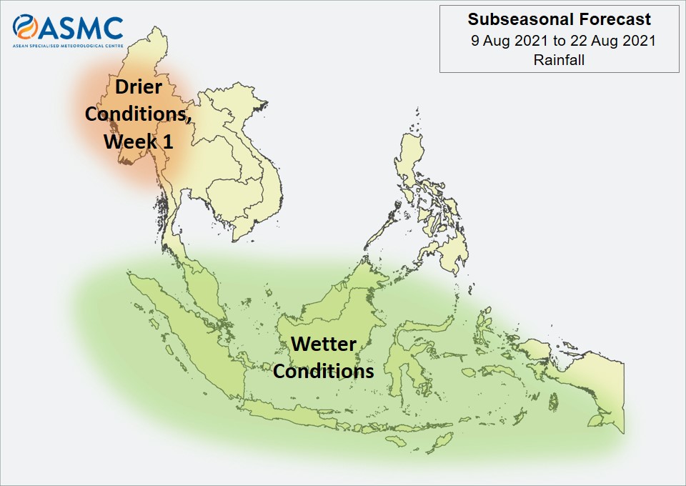
Wetter conditions are expected in Week 1 (9 – 15 August) over most of the southern ASEAN region. These wetter conditions are expected to persist in Week 2 (16 – 22 August) except for parts of the western Maritime Continent.

Drier conditions are expected in Week 1 (9 – 15 August) over western parts of Mainland Southeast Asia.

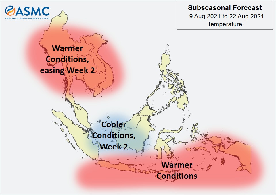
Warmer temperatures than usual are expected in Week 1 (9 – 15 August) over most of Mainland Southeast Asia, easing in Week 2 (16 – 22 August). Elsewhere, warmer temperatures are also expected over southern parts of the Maritime Continent in the next fortnight (9 – 22 August).

Cooler temperatures than usual are expected in Week 2 (16 – 22 August) over parts of the central Maritime Continent.

An MJO signal was present over the Western Hemisphere and Africa (Phase 8) at the beginning of August, although the signal was no longer discernible based on the RMM Index by the start of the forecast period. Some models predict the MJO to reemerge in Week 1 (either in Phase 1 or Phase 2) and continue propagating eastwards over the Indian Ocean (Phases 2 and 3).
 
The outlook is assessed for the region in general, where conditions are relative to the average conditions for the corresponding time of year. For specific updates on the national scale, the relevant ASEAN National Meteorological and Hydrological Services should be consulted.

July 23, 2021

Subseasonal Weather Outlook (26 July – 8 August 2021)

Subseasonal Weather Outlook (26 July – 8 August 2021)

Issued 23 July 2021
First forecast week: 26 July – 1 August
Second forecast week: 2 August – 8 August

figure1

Figure 1: Rainfall Outlook

figure2

Figure 2: Temperature Outlook


Drier conditions are expected in the next fortnight (26 July – 8 August) over much of the northern ASEAN region. While the outlook is for generally drier than average conditions for the area outlined, there still may be isolated regions of wetter than average rainfall, particularly for Mainland Southeast Asia.

Wetter conditions are expected in Week 2 (2 – 8 August) over much of the southern and western Maritime Continent.

Warmer temperatures than usual are expected over much of the ASEAN region during the next fortnight (26 July – 8 August), apart from northwestern Mainland Southeast Asia.

An MJO signal was present over the Maritime Continent (Phases 4 and 5) in the middle of July. Most models predict the MJO to weaken as it moves over the Western Pacific (Phase 6) at the start of Week 1 (26 July – 1 August).

The outlook is assessed for the region in general, where conditions are relative to the average conditions for the corresponding time of year. For specific updates on the national scale, the relevant ASEAN National Meteorological and Hydrological Services should be consulted.

July 9, 2021

Subseasonal Weather Outlook (12 – 25 July 2021)

Subseasonal Weather Outlook (12 – 25 July 2021)

Issued 9 July 2021
First forecast week: 12 July – 18 July
Second forecast week: 19 July – 25 July

figure1

Figure 1: Rainfall Outlook

figure2

Figure 2: Temperature Outlook


Wetter conditions are expected in Week 1 (12 – 18 July) over much of the central and eastern Maritime Continent, as well as the southeastern part of Mainland Southeast Asia. In Week 2 (19 – 25 July), these wetter conditions are expected to ease, apart from over the southeastern part of the Maritime Continent.

Drier conditions are expected in the next fortnight (12 – 25 July) over parts of the western Maritime Continent. These drier conditions may extend eastwards in Week 2 (19 – 25 July) to cover western parts of Borneo.

Warmer temperatures than usual are expected over the southern part of the Maritime Continent in Week 1 (12 – 18 July). These warmer conditions are expected to extend to most of the Maritime Continent and southern parts of Mainland Southeast Asia in Week 2 (19 – 25 July).

An MJO signal was present over the Indian Ocean (Phases 2 and 3) at the beginning of July. Some models predict the MJO to continue propagating eastwards over the Maritime Continent (Phases 4 and 5).

The outlook is assessed for the region in general, where conditions are relative to the average conditions for the corresponding time of year. For specific updates on the national scale, the relevant ASEAN National Meteorological and Hydrological Services should be consulted.

June 25, 2021

Subseasonal Weather Outlook (28 June – 11 July 2021)

Subseasonal Weather Outlook (28 June – 11 July 2021)

Issued 25 June 2021
First forecast week: 28 June – 4 July
Second forecast week: 5 July – 11 July

figure1

Figure 1: Rainfall Outlook

figure2

Figure 2: Temperature Outlook


Wetter conditions are expected over the southern parts of the Maritime Continent in Week 1 (28 June – 4 July). In Week 2 (5 – 11 July), there is an increased chance of wetter conditions continuing, particularly over the southeastern parts of the Maritime Continent.

In Week 1 (28 June – 4 July), drier conditions are expected over much of the northern ASEAN region. Most of this region is expected to transition to wetter conditions in Week 2 (5 – 11 July) except for coastal regions of Myanmar where the drier conditions are expected to persist.

Warmer temperatures than usual are expected over much of Mainland Southeast Asia in the next fortnight (28 June – 11 July), although these warmer conditions may ease over its eastern parts in Week 2 (5 – 11 July), coinciding with the wetter conditions.

A less coherent MJO signal was present over the Western Hemisphere and Africa (Phase 1) towards the end of June. There is disagreement between the models regarding the MJO’s development. Some models predict the MJO to continue propagating eastwards and strengthen over the Maritime Continent (Phases 4 and 5).
 
The outlook is assessed for the region in general, where conditions are relative to the average conditions for the corresponding time of year. For specific updates on the national scale, the relevant ASEAN National Meteorological and Hydrological Services should be consulted.

June 11, 2021

Subseasonal Weather Outlook (14 – 27 June 2021)

Subseasonal Weather Outlook (14 – 27 June 2021)

Issued 11 June 2021
First forecast week: 14 June – 20 June
Second forecast week: 21 June – 27 June

figure1

Figure 1: Rainfall Outlook

figure2

Figure 2: Temperature Outlook


In Week 1 (14 – 20 June), wetter conditions are expected to develop over the western coastal region of Myanmar before transiting to drier conditions in Week 2 (21 – 27 June).

Over much of the rest of the northern ASEAN region, there is an increased chance of drier conditions than usual during the next fortnight (14 – 27 June).

Warmer temperatures than usual are expected over much of the southern parts of the Maritime Continent in the next fortnight (14 – 27 June). Warmer conditions may also develop over much of Mainland Southeast Asia, particularly inland areas, in Week 2 (21 – 27 June).

The MJO signal was no longer discernable based on the RMM Index. Some models predict an MJO signal to emerge either in the Western Hemisphere and Africa (Phases 8 and 1) or the Indian Ocean (Phases 2 and 3) during the forecast period.
 
The outlook is assessed for the region in general, where conditions are relative to the average conditions for the corresponding time of year. For specific updates on the national scale, the relevant ASEAN National Meteorological and Hydrological Services should be consulted.

May 28, 2021

Subseasonal Weather Outlook (31 May – 13 June 2021)

Subseasonal Weather Outlook (31 May – 13 June 2021)

Issued 28 May 2021
First forecast week: 31 May – 6 June
Second forecast week: 7 June – 13 June

figure1

Figure 1: Rainfall Outlook

figure2

Figure 2: Temperature Outlook


For Mainland Southeast Asia, an increased chance of drier conditions is predicted over much of the region in Week 1 (31 May – 6 June). In Week 2 (7 – 13 June), wetter conditions may develop over the western coastal region.

Elsewhere in the next fortnight (31 May – 13 June), an increased chance of drier conditions is predicted over much of the southern ASEAN region, particularly over the central equatorial region. Wetter conditions than usual are expected over central and southern Philippines in the next fortnight.

Warmer temperatures than usual are expected over much of the ASEAN region in Week 1 (31 May – 6 June), in particular over Mainland Southeast Asia, northern Philippines and parts of the southern Maritime Continent.

Towards the end of May, an MJO signal was present over the Western Pacific (Phase 6). However, this MJO signal is no longer discernible based on the RMM Index and the models are uncertain as to how the MJO will evolve over the forecast period.

The outlook is assessed for the region in general, where conditions are relative to the average conditions for the corresponding time of year. For specific updates on the national scale, the relevant ASEAN National Meteorological and Hydrological Services should be consulted.

May 14, 2021

Subseasonal Weather Outlook (17 – 30 May 2021)

Subseasonal Weather Outlook (17 – 30 May 2021)

Issued 14 May 2021
First forecast week: 17 May – 23 May
Second forecast week: 24 May – 30 May

figure1

Figure 1: Rainfall Outlook

figure2

Figure 2: Temperature Outlook


An increased chance of wetter conditions is expected over parts of the eastern Maritime Continent in Week 1 (17 – 23 May). Models are also predicting wetter conditions over southern Viet Nam and Cambodia, although with a lower confidence compared to the eastern Maritime Continent.

Drier conditions than usual are expected over much of northwestern Mainland Southeast Asia in Week 1 (17 – 23 May).

Warmer temperatures than usual are expected over much of northwestern Mainland Southeast Asia in Week 1 (17 – 23 May). These warmer temperatures are expected to ease and become confined mainly to northern parts of Myanmar and Lao PDR in Week 2 (24 – 30 May).

A weak Madden-Julian Oscillation (MJO) signal was present over the Indian Ocean (Phases 2 and 3). While the MJO signal is expected to be less coherent at the start of the forecast period, most models forecast the MJO to propagate eastwards and move into the Maritime Continent (Phase 4) by middle of Week 1. By end of May, some models predict the MJO to reach the Western Pacific (Phases 6 and 7).

The outlook is assessed for the region in general, where conditions are relative to the average conditions for the corresponding time of year. For specific updates on the national scale, the relevant ASEAN National Meteorological and Hydrological Services should be consulted.

April 30, 2021

Subseasonal Weather Outlook (3 – 16 May 2021)

Subseasonal Weather Outlook (3 – 16 May 2021)

Issued 30 April 2021
First forecast week: 3 May – 9 May
Second forecast week: 10 May – 16 May

figure1

Figure 1: Rainfall Outlook

figure2

Figure 2: Temperature Outlook


Wetter conditions are expected over parts of the western and central Maritime Continent in Week 1 (3 – 9 May) and may extend northward to coastal regions of southern Viet Nam. These wetter conditions are expected to ease in Week 2 (10 – 16 May) and be confined mainly to northern Sumatra and Peninsular Malaysia.

Drier conditions than usual are expected over much of the southern parts of the Maritime Continent in the next fortnight (3 – 16 May).

Cooler temperatures than usual are expected over parts of the western and central Maritime Continent in the next fortnight (3 – 16 May).

A strong Madden-Julian Oscillation (MJO) signal was present over the Western Hemisphere and Africa (Phase 8) at the end of April. Most models forecast the MJO to weaken in May as it propagates eastwards, decaying over the Indian Ocean towards the end of Week 1.
 
The outlook is assessed for the region in general, where conditions are relative to the average conditions for the corresponding time of year. For specific updates on the national scale, the relevant ASEAN National Meteorological and Hydrological Services should be consulted.

April 16, 2021

Subseasonal Weather Outlook (19 April – 2 May 2021)

Subseasonal Weather Outlook (19 April – 2 May 2021)

Issued 16 April 2021
First forecast week: 19 April – 25 April
Second forecast week: 26 April – 2 May

figure1

Figure 1: Rainfall Outlook

figure2

Figure 2: Temperature Outlook


Wetter conditions are expected over northern and central Philippines in Week 1 (19 – 25 April) associated with tropical cyclone activity. There is also a chance of wetter conditions over southern Myanmar, southern Thailand, southern Cambodia, and central and southern Viet Nam in Week 1.

Drier conditions than usual are expected over much of the southern ASEAN region in Week 1 (19 – 25 April). The drier conditions are expected to ease in Week 2 (26 April – 2 May).

Cooler temperatures than usual are expected over central and southeastern Mainland Southeast Asia, as well as northern and central Philippines, in the next fortnight (19 April – 2 May).

A strong Madden-Julian Oscillation (MJO) signal was present over the Western Pacific (Phase 7) in the middle of April. Most models predict this signal to continue propagating eastwards during the next fortnight, entering the Western Hemisphere and Africa (Phase 8) by Week 2.
 
The outlook is assessed for the region in general, where conditions are relative to the average conditions for the corresponding time of year. For specific updates on the national scale, the relevant ASEAN National Meteorological and Hydrological Services should be consulted.

April 1, 2021

Subseasonal Weather Outlook (5 – 18 April 2021)

Subseasonal Weather Outlook (5 – 18 April 2021)

Issued 1 April 2021
First forecast week: 5 April – 11 April
Second forecast week: 12 April – 18 April

figure1

Figure 1: Rainfall Outlook

figure2

Figure 2: Temperature Outlook


Wetter conditions are expected over much of the northern ASEAN region as well as northern Borneo, northern Sulawesi, and Maluku Islands in the next fortnight (5 – 18 April). In particular, for Week 1 (5 – 11 April) the highest probability of wetter conditions is over northern Lao PDR and much of Thailand. For Week 2 (12 – 18 April), the highest probability for wetter conditions is over southern Thailand, Cambodia, southern Viet Nam, and the Philippines.

Conversely, slightly drier conditions than usual are expected over much of the southern ASEAN region in Week 1 (5 – 11 April). There is a chance that these drier conditions may continue into Week 2 (12 – 18 April), although the confidence is low.

Cooler temperatures than usual are expected over much of Mainland Southeast Asia in the next fortnight (5 – 18 April), in line with the wetter conditions predicted. Warmer conditions than usual are expected over most of the equatorial region in Week 1 (5 – 11 April) and are expected to return to near-normal in Week 2 (12 – 18 April).

A moderate Madden-Julian Oscillation (MJO) signal was present over the Maritime Continent at the start of April. Models predict this MJO signal to continue propagating eastwards reaching the Western Pacific (Phase 6) at the start of Week 1, before weakening in Phase 7.
 
The outlook is assessed for the region in general, where conditions are relative to the average conditions for the corresponding time of year. For specific updates on the national scale, the relevant ASEAN National Meteorological and Hydrological Services should be consulted.