Category Archives: Regional Weather Outlook for Year 2025

March 12, 2025

Subseasonal Weather Outlook (17 – 30 March 2025)

Subseasonal Weather Outlook (17 – 30 March 2025)

Issued: 12 March 2025
First forecast week: 17 – 23 March 2025
Second forecast week: 24 – 30 March 2025

figure1

Figure 1: Rainfall Outlook

figure2

Figure 2: Temperature Outlook

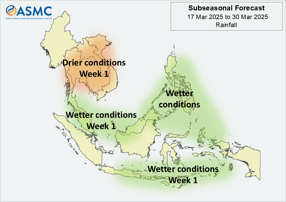
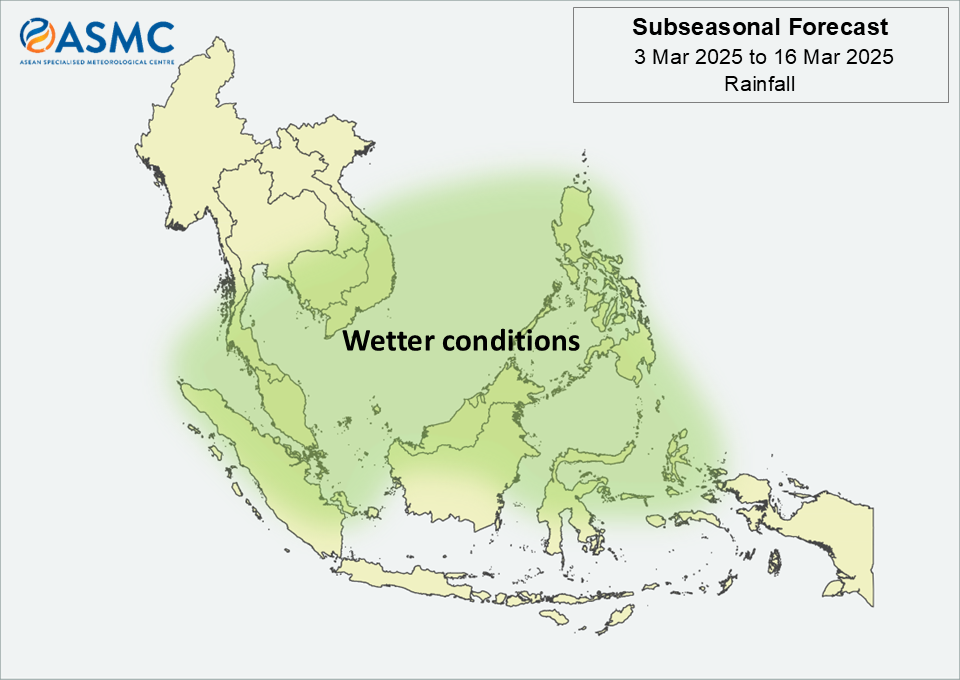
Wetter conditions are predicted over much of the Maritime Continent in Week 1 (17 – 23 March). The wetter conditions are predicted to persist over the northeastern Maritime Continent in Week 2 (24 – 30 March).

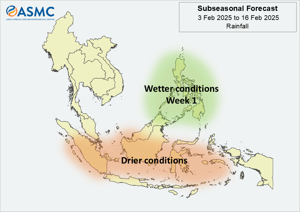
Drier conditions are predicted over central and eastern Mainland Southeast Asia in Week 1 (17 – 23 March).

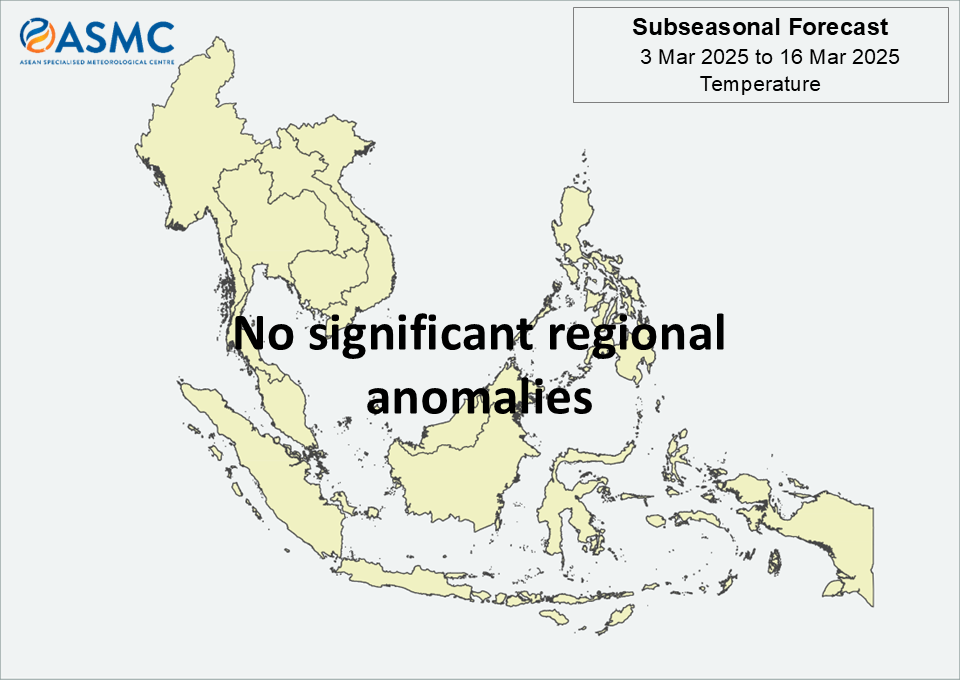
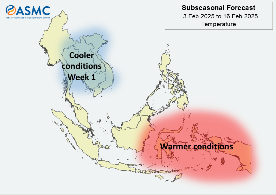
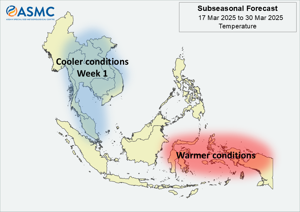
Cooler than usual temperature is predicted over central and eastern Mainland Southeast Asia and much of the Malay Peninsula in Week 1 (17 – 23 March). Warmer conditions are predicted over parts of the eastern equatorial region in the next fortnight (17 – 30 March).

A Madden-Julian Oscillation (MJO) signal was present over the Western Hemisphere and Africa (Phase 1) during the first week of March, based on the RMM Index. Most models predict the signal to weaken and become indiscernible around the start of the forecast period. Some models predict an MJO signal to emerge and then strengthen over the Western Pacific (Phases 6 and 7) during Week 2.

The outlook is assessed for the region in general, where conditions are relative to the average conditions for the corresponding time of year. For specific updates on the national scale, the relevant ASEAN National Meteorological and Hydrological Services should be consulted.

February 26, 2025

Subseasonal Weather Outlook (3 – 16 March 2025)

Subseasonal Weather Outlook (3 – 16 March 2025)

Issued: 26 February 2025
First forecast week: 3 March – 9 March 2025
Second forecast week: 10 March – 16 March 2025

figure1

Figure 1: Rainfall Outlook

figure2

Figure 2: Temperature Outlook

Wetter conditions are predicted over much of the Maritime Continent (except for the southern and southeastern parts) and southeastern Mainland Southeast Asia in the next fortnight (3 – 16 March).

No significant regional temperature anomalies are predicted in the next fortnight (3 – 16 March).

A weak Madden-Julian Oscillation (MJO) signal was present over the Western Hemisphere and Africa (Phases 8 and 1) towards the end of February, based on the RMM Index. Most models do not indicate coherent MJO activity during the forecast period. However, some models predict an MJO signal to briefly propagate over the Indian Ocean (Phases 2 and 3) before decaying in Week 1 (3 – 9 March).

The outlook is assessed for the region in general, where conditions are relative to the average conditions for the corresponding time of year. For specific updates on the national scale, the relevant ASEAN National Meteorological and Hydrological Services should be consulted.

February 12, 2025

Subseasonal Weather Outlook (17 February – 2 March 2025)

Subseasonal Weather Outlook (17 February – 2 March 2025)

Issued: 12 February 2025
First forecast week: 17 – 23 February 2025
Second forecast week: 24 February – 2 March 2025

figure1

Figure 1: Rainfall Outlook

figure2

Figure 2: Temperature Outlook

Wetter conditions are predicted over much of the Maritime Continent in the next fortnight (17 February – 2 March).

No significant regional temperature anomalies are predicted in the next fortnight (17 February – 2 March).

A Madden-Julian Oscillation (MJO) signal was present over the Western Pacific (Phases 6 and 7) in the second week of February. Models predict this MJO signal to propagate eastwards, reaching the Western Hemisphere and Africa (Phase 8) by the start of the forecast period. Most models predict the MJO to remain in Phase 8 throughout Week 1 (17 – 23 February), with some models indicating a weakening of the signal in Week 2 (24 February – 2 March).

The outlook is assessed for the region in general, where conditions are relative to the average conditions for the corresponding time of year. For specific updates on the national scale, the relevant ASEAN National Meteorological and Hydrological Services should be consulted.

January 28, 2025

Subseasonal Weather Outlook (3 – 16 February 2025)

Subseasonal Weather Outlook (3 – 19 February 2025)

Issued: 28 January 2025
First forecast week: 3 – 9 February 2025
Second forecast week: 10 – 16 February 2025

figure1

Figure 1: Rainfall Outlook

figure2

Figure 2: Temperature Outlook

Wetter conditions are predicted over the northeastern Maritime Continent in Week 1 (3 – 9 February).

Drier conditions are predicted over parts of the equatorial region in the next fortnight (3 – 16 February).

For temperature, cooler than normal conditions are predicted over central and eastern Mainland Southeast Asia in Week 1 (3 – 9 February). Warmer than normal temperature is predicted over the southeastern Maritime Continent in the next fortnight (3 – 16 February).

Towards the end of January, an MJO signal was present over the Maritime Continent (Phase 4), based on the RMM index. Models are split between the signal becoming inactive around the start of the forecast period and the signal continuing to propagate eastwards reaching the Western Pacific (Phases 6 and 7) during Week 1.

The outlook is assessed for the region in general, where conditions are relative to the average conditions for the corresponding time of year. For specific updates on the national scale, the relevant ASEAN National Meteorological and Hydrological Services should be consulted.

January 15, 2025

Subseasonal Weather Outlook (20 January – 2 February 2025)

Subseasonal Weather Outlook (20 January – 2 February 2025)

Issued: 15 January 2025
First forecast week: 20 – 26 January 2025
Second forecast week: 27 January – 2 February 2025

figure1

Figure 1: Rainfall Outlook

figure2

Figure 2: Temperature Outlook

Wetter conditions are predicted over much of the Maritime Continent in Week 1 (20 – 26 January).

Drier conditions are predicted over parts of southern and eastern Mainland Southeast Asia in Week 1 (20 – 26 January).

No significant regional temperature anomalies are predicted in the next fortnight (20 January – 2 February).

A Madden-Julian Oscillation (MJO) signal was present over the Western Hemisphere and Africa (Phases 8 and 1) in the second week of January based on the RMM index. Models predict this MJO signal to continue propagating eastwards over the Indian Ocean (Phase 3) during Week 1. In Week 2, most models predict the signal to weaken as it moves through the Maritime Continent (Phases 4 and 5).

The outlook is assessed for the region in general, where conditions are relative to the average conditions for the corresponding time of year. For specific updates on the national scale, the relevant ASEAN National Meteorological and Hydrological Services should be consulted.

January 2, 2025

Subseasonal Weather Outlook (6 – 19 January 2025)

Subseasonal Weather Outlook (6 – 19 January 2025)

Issued: 2 January 2025
First forecast week: 6 – 12 January 2025
Second forecast week: 13 – 19 January 2025

figure1

Figure 1: Rainfall Outlook

figure2

Figure 2: Temperature Outlook

Wetter conditions are predicted over much of the central and western Maritime Continent in the next fortnight (6 – 19 January).

Cooler than usual temperature is expected over much of the northern ASEAN region in Week 1 (6 – 12 January). These cooler conditions may persist over Mainland Southeast Asia in Week 2 (13 – 19 January).

A Madden-Julian Oscillation (MJO) signal was present over the Western Pacific (Phase 7) at the start of the year. Models predict this MJO signal to become inactive during the first week of January, then re-emerge over the Western Hemisphere (Phases 8 and 1) in Week 1. Most models predict the signal to continue propagating eastwards through the Indian Ocean (Phases 2 and 3) during Week 2.

The outlook is assessed for the region in general, where conditions are relative to the average conditions for the corresponding time of year. For specific updates on the national scale, the relevant ASEAN National Meteorological and Hydrological Services should be consulted.