Category Archives: Haze Review

CR58

July 18, 2024

Review of Regional Haze Situation for June 2024

Review of Regional Haze Situation for June 2024

1.1 Southwest Monsoon conditions were fully established over the ASEAN region in June 2024. Over the Philippines and much of the southern ASEAN region, the prevailing winds blew mainly from the southeast. The prevailing winds over the Mekong sub-region were mostly southwesterly or westerly while the regions close to the Equator experienced winds that were mostly light and variable in direction (Figure 1).

1.2 During the review period, rainy weather prevailed over most parts of the ASEAN region. In particular, moderate to heavy showers fell on several days over the Philippines, southern Myanmar and northern Viet Nam. Drier conditions were observed over Java and the Lesser Sunda Islands (Figure 1).

Figure 1: Average Daily Rainfall and Mean Winds for June 2024. (Source: JAXA GsMaP and GFS, respectively)


1.3 Hotspot activity in the ASEAN region was mostly subdued in June 2024 due to the prevailing wet weather conditions. The total number of hotspots were lower or comparable to previous years of the same period (Figure 2 and 3).


Figure 2: Hotspot counts for the northern ASEAN region for June (2020-2024) based on NOAA-20 satellite surveillance.


Figure 3: Hotspot counts for the southern ASEAN region for June (2020-2024) based on NOAA-20 satellite surveillance.


1.4 In June 2024, a few to isolated hotspots were detected in the ASEAN region, particularly in the southern and central parts of Viet Nam where the fires were more persistent and intense(Figure 4 and 5). There was no significant smoke haze observed via satellite imagery and ground reports.


Figure 4: Distribution of hotspots detected in June 2024 based on NOAA-20 satellite surveillance.


Figure 5: Maximum fire intensity in June 2024 based on NOAA-20 satellite surveillance.


June 14, 2024

Review of Regional Haze Situation for May 2024

Review of Regional Haze Situation for May 2024

1.1 In early May 2024, the prevailing winds, especially over the Mekong sub-region and the South China Sea, were light and variable as inter-monsoon conditions continued. Prevailing winds for areas located south of the Equator then transitioned into southeasterlies from mid-May onwards, indicating the development of the Southwest Monsoon. Winds located to the east of the Philippines continue to be easterly in May 2024. (Figure 1).

1.2 Rainfall was observed over most of the ASEAN region except for Java and the Lesser Sunda Islands, where conditions were drier. The increase in precipitation in the Mekong sub-region compared to April 2024 resulted in the reduction of hotspots in the sub-region. (Figure 1) The Alert level was downgraded to Level 2 on 6 May, Level 1 on 13 May and subsequently Level 0 on 23 May, signaling the end of the dry season for the Mekong sub-region.

Figure 1: Average Daily Rainfall and Mean Winds for May 2024. (Source: JAXA GsMaP and GFS, respectively)


1.3 The hotspot count in May 2024 for Peninsular Malaysia, Sabah and Sarawak were higher when compared to previous years. However, for Kalimantan and Sumatra, the hotspot counts for May 2024 were lower. (Figure 3). Elsewhere in the ASEAN region, especially in the Mekong sub-region, the number of hotspots remain comparable with previous years.


Figure 2: Hotspot counts for the northern ASEAN region for May (2020-2024) based on NOAA-20 satellite surveillance.


Figure 3: Hotspot counts for the southern ASEAN region for May (2020-2024) based on NOAA-20 satellite surveillance.


1.4 In May 2024, isolated to scattered hotspots were detected mainly in the Mekong sub-region and the Philippines, especially in the northern parts of Lao PDR and the southern parts of Myanmar where fire intensity and hotspot persistency were more pronounced. (Figure 4 and 5) During early May, moderate to dense transboundary smoke haze was observed over the northern parts of Lao PDR, the northern parts of Thailand, as well as the eastern and southern parts of Myanmar. The transboundary smoke haze was shown to drift in the north-east direction into the northern parts of Viet Nam and Lao PDR (Figure 6 and 7).

1.5 Hotspot activity remained mostly subdued in the southern ASEAN region except for a few persistent hotspots in the eastern parts of Peninsular Malaysia (Figure 4). Localised smoke plumes were observed to emanate from these hotspots on some days. (Figure 8)


Figure 4: Distribution of hotspots detected in May 2024 based on NOAA-20 satellite surveillance.


Figure 5: Maximum fire intensity in May 2024 based on NOAA-20 satellite surveillance.


Figure 6: Number of days with moderate to dense smoke haze observed in May 2024 based on satellite imagery, ground observations, and air quality reports.


Figure 7: Widespread moderate transboundary smoke haze covering the northern parts of Lao PDR and Thailand on 1 May 2024. (Source: NOAA-20 satellite surveillance)


Figure 8: On 15 May 2024, localised smoke plumes were observed to emanate from hotspots in the eastern parts of Peninsular Malaysia and the southern parts of Thailand. (Source: NOAA-20 satellite surveillance)

May 13, 2024

Review of Regional Haze Situation for April 2024

Review of Regional Haze Situation for April 2024

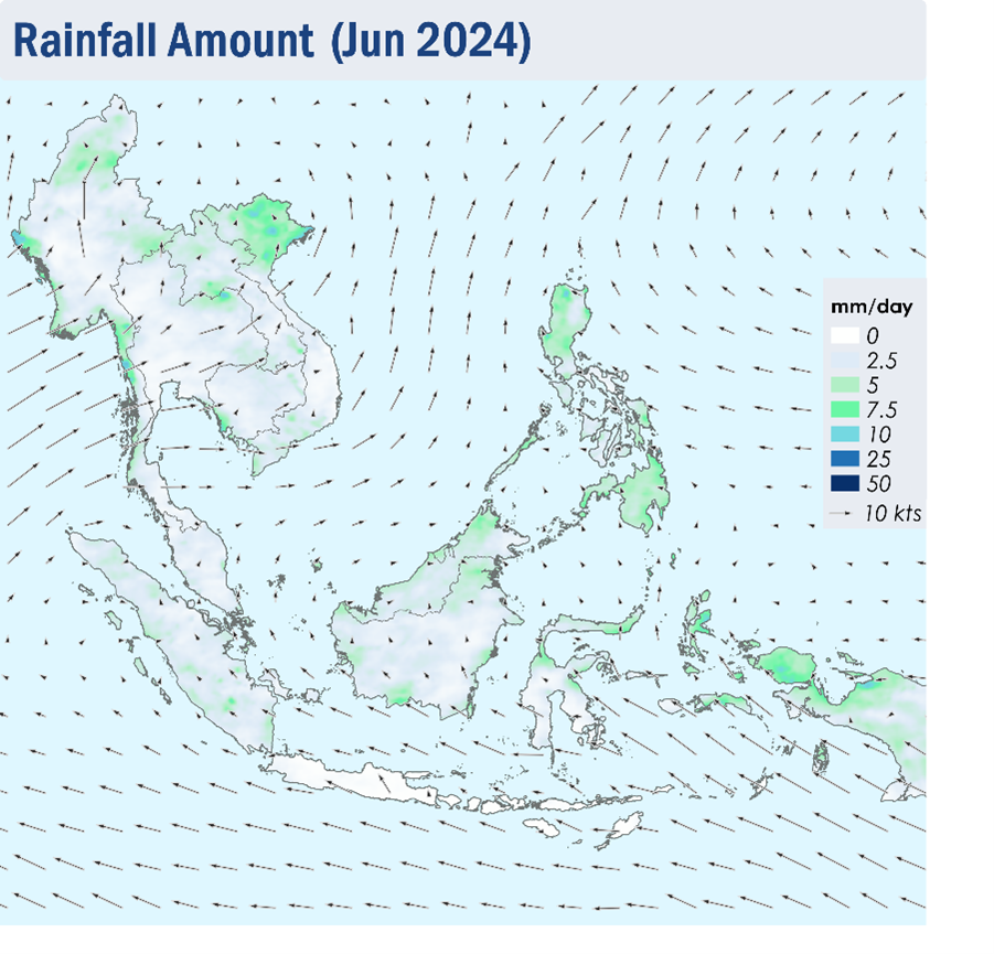
1.1 In April 2024, the prevailing winds over areas near the Equator turned light and variable in direction as the monsoon rainband shifted northwards towards the Equator. This is characterised with the transition of the Northeast Monsoon to the inter-monsoon conditions. Over the northern ASEAN region, the prevailing winds over the Philippines blew mostly from the northeast or east. While the prevailing winds over the northern parts of the Mekong sub-region were light and variable in direction, the prevailing winds over the rest of the sub-region blew mostly from the south or southwest (Figure 1).

1.2 Although some rainfall was observed over the northern, southeastern and central parts of the Mekong sub-region as well as the southern parts of the Philippines on a few days, dry conditions persisted over the northern ASEAN region on most days of the review period. The southern ASEAN region experienced wet weather on most days of the outlook period, except for the eastern parts of Borneo and the northern parts of Peninsular Malaysia and Sumatra where conditions were drier (Figure 1).

Figure 1: Average Daily Rainfall and Mean Winds for April 2024. (Source: JAXA GsMaP and GFS, respectively)


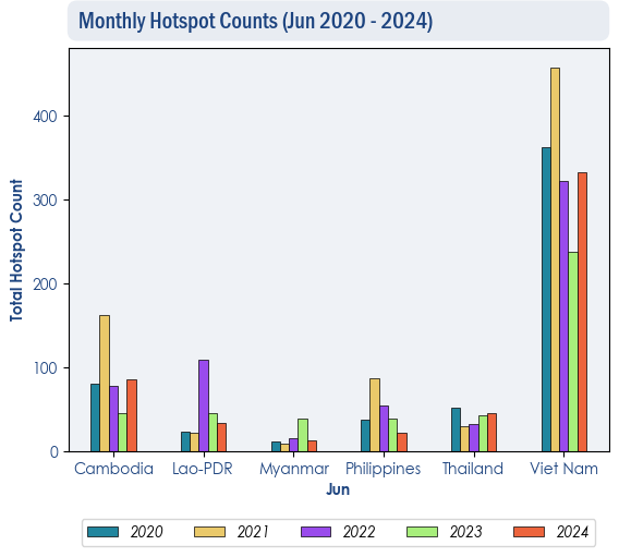
1.3 During the review period, the hotspot counts over the Mekong sub-region in April 2024 were largely higher or comparable to recent years (Figure 2). Over the southern ASEAN region, hotspot counts for Kalimantan and Malaysia in April 2024 were higher compared to previous years, but still relatively low compared to during the dry season. Elsewhere in the region, the hotspot counts were comparable to previous years (Figure 3).


Figure 2: Hotspot counts for the northern ASEAN region for April (2020-2024) based on NOAA-20 satellite surveillance.


Figure 3: Hotspot counts for the southern ASEAN region for April (2020-2024) based on NOAA-20 satellite surveillance.


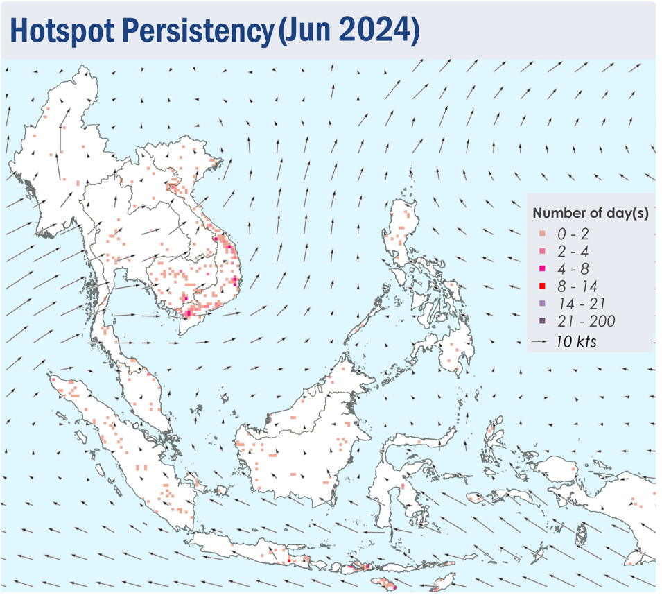
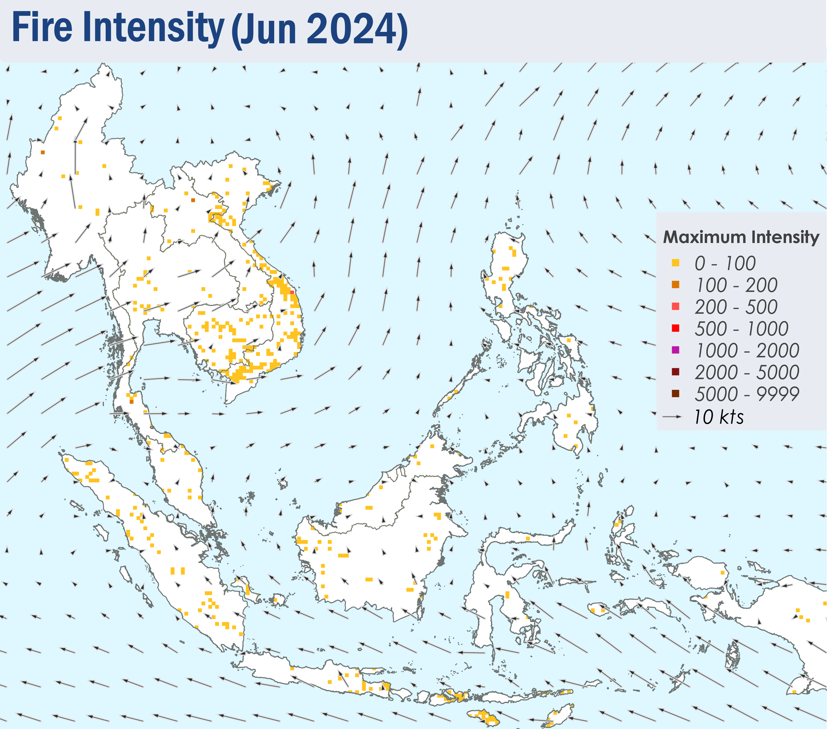
1.4 In April 2024, scattered to widespread hotspots continued to be detected in the Mekong sub-region, with more intense and persistent clusters of hotspots in Lao PDR, various parts of Myanmar, northern Thailand and the northeastern parts of Cambodia (Figure 4 and 5). During most days of the review period, widespread moderate to dense transboundary smoke haze was observed to cover the eastern parts of Myanmar, northern and central parts of Thailand, and the northern parts of Lao PDR and Viet Nam (Figure 6 and 7). Moderate to dense smoke haze was also observed over other parts of Myanmar, Cambodia, and the eastern parts of Thailand (Figure 6). Moderate smoke plumes emanating from the hotspot clusters detected in the southern and central parts of Lao PDR were observed to drift northeastwards into the central parts of Viet Nam on a few days (Figure 6 and 8).

1.5 While the hotspot activity over the southern ASEAN region remained low, there were a few more intense and persistent hotspots detected in the eastern coastal areas of Peninsular Malaysia and the eastern parts of Kalimantan (Figure 4 and 5). Localised moderate smoke plumes (Figure 6, 9 and 10) were observed to emanate from these hotspots on some days.


Figure 4: Distribution of hotspots detected in April 2024 based on NOAA-20 satellite surveillance.


Figure 5: Maximum fire intensity in April 2024 based on NOAA-20 satellite surveillance.


Figure 6: Number of days with moderate to dense smoke haze observed in April 2024 based on satellite imagery, ground observations, and air quality reports.


Figure 7: Widespread moderate to dense transboundary smoke haze covering the eastern parts of Myanmar, northern and central parts of Thailand, and the northern parts of Lao PDR and Viet Nam on the 5 April 2024. (Source: NOAA-20 satellite surveillance)


Figure 8: Moderate smoke plumes emanating from the hotspot clusters detected in the southern and central parts of Lao PDR were observed to drift northeastwards into the central parts of Viet Nam on the 30 April 2024. (Source: NOAA-20 satellite surveillance)


Figure 9: Localised smoke plumes observed to emanate from the hotspots detected in the eastern coastal areas of Peninsular Malaysia on 29 April 2024. (Source: NOAA-20 satellite surveillance)


Figure 10: Localised smoke plumes observed in the eastern parts of Kalimantan on 18 April 2024. (Source: Himawari-9 satellite surveillance)


April 5, 2024

Review of Regional Haze Situation for March 2024

Review of Regional Haze Situation for March 2024

1.1 The Northeast Monsoon conditions continued over the ASEAN region in March 2024. Over areas north of the equator, the prevailing winds blew mainly from the east to northeast although light and variable winds prevailed over most parts of the Mekong sub-region. The prevailing winds over areas south of the Equator blew mostly from the west or northwest. As the Northeast monsoon conditions gradually weakened in the last week of the month, the prevailing winds over most of the ASEAN region started to turn light and variable on several days during the review period. (Figure 1).

1.2 The Mekong sub-region remained dry throughout the review period of March 2024, except for isolated shower activities in some parts of the sub-region on a few days. Elsewhere in the ASEAN region, generally wet conditions were observed in many areas, except for parts of Peninsular Malaysia, northeastern Borneo and the Philippines where there were brief periods of drier weather (Figure 1).

Figure 1: Average Daily Rainfall and Mean Winds for March 2024. (Source: JAXA GsMaP and GFS, respectively)


1.3 Over the Mekong sub-region, the hotspot counts in March 2024 were either lower or comparable to previous years (Figure 2). Over the southern ASEAN region, the hotspot counts were higher or comparable to the past few years, with an increase in Kalimantan, Peninsular Malaysia as well as Sabah and Sarawak. Kalimantan, Sabah and Sarawak recorded the highest hotspot count over 5 years (Figure 3), although the hotspot count for the southern ASEAN region during the review period remained relatively low.


Figure 2: Hotspot counts for the northern ASEAN region for March (2020-2024) based on NOAA-20 satellite surveillance.


Figure 3: Hotspot counts for the southern ASEAN region for March (2020-2024) based on NOAA-20 satellite surveillance.


1.4 Scattered to widespread hotspots were detected over many areas of the Mekong sub-region in March, with more intense and persistent clusters of hotspots in eastern Myanmar, Lao PDR, northern Thailand, and northeastern Cambodia. (Figure 4 and 5). Widespread transboundary moderate to dense smoke haze was observed mainly in the vicinity of the hotspot clusters in eastern Myanmar, northern and central Thailand, Lao PDR, as well as northern Cambodia and northern Viet Nam (Figure 6 and 7) on many days. With the deteriorating hotspots and haze situation, Alert Level 3 was issued for the Mekong sub-region on 6 Mar 2024. For the southern ASEAN region, localised moderate smoke plumes were also observed emanating from a few hotspots in eastern Peninsular Malaysia on some days during brief dry periods.


Figure 4: Distribution of hotspots detected in March 2024 based on NOAA-20 satellite surveillance.


Figure 5: Maximum fire intensity in March 2024 based on NOAA-20 satellite surveillance.


Figure 6: Number of days with moderate to dense smoke haze observed in March 2024 based on satellite imagery, ground observations, and air quality reports.


Figure 7: Moderate to dense transboundary smoke plumes were observed drifting in an easterly direction across eastern and southern Myanmar, the northern parts of Lao PDF, as well as northern and western Thailand on 31st March 2024. (Source: NOAA 20 satellite surveillance)


March 8, 2024

Review of Regional Haze Situation for February 2024

Review of Regional Haze Situation for February 2024

1.1 1.1 The ASEAN region continued to experience Northeast Monsoon conditions in February 2024. Over areas north of the Equator, the prevailing winds blew mainly from the northeast except over the Mekong sub-region where the winds were mostly light and variable in direction. Over areas south of the Equator, the prevailing winds blew mostly from the northwest or north (Figure 1).

1.2 1.2 The Mekong sub-region remained dry throughout the review period of February 2024, with moderate to dense haze observed over many parts of the sub-region (Figure 6) on several days. On 7 February 2024, the Alert Level 2 for the Mekong sub-region was activated in view of the increasing hotspots and risk of transboundary haze in the Mekong sub-region. Showers were observed elsewhere in the ASEAN region, except for parts of Peninsular Malaysia and the Philippines where there were brief periods of drier weather. The overall hotspot and haze situation in the southern ASEAN region and the Philippines stayed subdued (Figure 1).

Figure 1: Average Daily Rainfall and Mean Winds for February 2024. (Source: JAXA GsMaP and GFS, respectively)


1.3 1.3 Over the Mekong sub-region, the hotspot counts in February 2024 were comparable to previous years (Figure 2). Over the southern ASEAN region, the hotspot counts were higher or comparable, with a rise in Kalimantan, Peninsular Malaysia as well as Sabah and Sarawak compared to the past few years. Sabah and Sarawak recorded the highest hotspot count over 5 years (Figure 3), although the hotspot count for the southern ASEAN region during the review period remained relatively low.


Figure 2: Hotspot counts for the northern ASEAN region for February (2020-2024) based on NOAA-20 satellite surveillance.


Figure 3: Hotspot counts for the southern ASEAN region for February (2020-2024) based on NOAA-20 satellite surveillance.


1.4 1.4 Hotspot activities were persistent over many areas of the Mekong sub-region in February, with fires of higher intensity observed mainly over parts of Lao PDR and northeastern Cambodia (Figure 4 and 5). Moderate to dense smoke haze was observed mostly in the northern, western, and central parts of the sub-region (Figures 6, 7 and 8).


Figure 4: Distribution of hotspots detected in February 2024 based on NOAA-20 satellite surveillance.


Figure 5: Maximum fire intensity in February 2024 based on NOAA-20 satellite surveillance.


Figure 6: Number of days with moderate to dense smoke haze observed in February 2024 based on satellite imagery, ground observations, and air quality reports.


Figure 7: Moderate to dense transboundary smoke plumes were observed drifting from northeastern Cambodia into the southern parts of Lao PDF and eastern Thailand on 17 February 2024. (Source: Himawari-9 satellite surveillance)


Figure 8: Moderate to dense smoke haze was observed over the eastern, central and southern parts of Myanmar on 24 February 2024. (Source: Himawari-9 satellite surveillance)


February 13, 2024

Review of Regional Haze Situation for January 2024

Review of Regional Haze Situation for January 2024

1.1 Northeast monsoon conditions continued in January 2024, as suggested by the prevailing low-level winds. Winds over areas north of the Equator in the ASEAN region blew predominantly from the northeast or east while the winds over areas south of the Equator blew mostly from the northwest to west (Figure 1). On occasion, the northeasterly winds strengthened over the South China Sea, and brought periods of cloudiness and widespread rainfall associated with the monsoon surge to parts of eastern Peninsular Malaysia and Singapore.

1.2 Dry conditions persisted over the Mekong sub-region (Figure 1) under Alert Level 1. For the rest of the ASEAN region, increased rainfall was recorded except for the northern parts of the Philippines where conditions were relatively drier. Rainfall was much higher over the Mindanao region of the Philippines due to the presence of the Northeast Monsoon (Figure 1). The presence of monsoon surges continued in January which affected eastern areas in Peninsular Malaysia, causing fatalities and displacement of people, including damages to infrastructure and agriculture. (Figure 1)

Figure 1: Average Daily Rainfall and Mean Winds for January 2024. (Source: JAXA GsMaP and GFS, respectively)


1.3 The overall hotspot counts for the northern ASEAN region was generally lower in January 2024 compared to hotspots recorded for the same period in previous years, although hotspot counts in Cambodia were higher compared to the last three years. In the southern ASEAN region, the hotspot counts were generally lower or comparable to previous years (Figure 2 and 3).


Figure 2: Hotspot counts for the southern ASEAN region for January (2020-2024) based on NOAA-20 satellite surveillance.


Figure 3: Hotspot counts for the northern ASEAN region for January (2020-2024) based on NOAA-20 satellite surveillance.


1.4 Isolated to scattered hotspots were detected in the Mekong sub-region (Figure 4) and also the Philippines. Persistent clusters of moderate intensity hotspots, some with smoke plumes were observed consistently in the northeastern and eastern parts of Cambodia (Figure 4, 5 and 7).


Figure 4: Distribution of hotspots detected in January 2024 based on NOAA-20 satellite surveillance.


Figure 5: Maximum fire intensity in January 2024 based on NOAA-20 satellite surveillance.


Figure 6: Number of days with moderate to dense smoke haze observed in January 2024 based on satellite imagery, ground observations, and air quality reports.


Figure 7: Moderate haze was observed in the northeastern and eastern parts of Cambodia from January 2024 (Source: NOAA-20 satellite surveillance.)


January 8, 2024

Review of Regional Haze Situation for December 2023

Review of Regional Haze Situation for December 2023

1.1 In December 2023, the prevailing winds over areas north of the Equator in the ASEAN region blew mostly from the northeast or east while the prevailing winds over areas south of the Equator were predominantly light and variable in direction (Figure 1). This signalled the establishment of Northeast Monsoon conditions over the ASEAN region. At times during the month, the northeasterly winds strengthened over parts of the Mekong sub-region and the South China Sea as well as over Peninsular Malaysia and Singapore, and brought periods of widespread rainfall associated with the monsoon surge.

1.2 Dry conditions were observed over the Mekong sub-region except for the coastal areas in the southern parts of Viet Nam where some showers occurred (Figure 1). The Alert Level 1 for the onset of the dry season for the northern ASEAN region was issued on the 14 December 2023. Rainfall was recorded over the rest of the ASEAN region except for the northern and the central parts of the Philippines where conditions were dry. Rainfall was noticeably higher over the eastern coastal areas of Peninsular Malaysia, southern parts of Thailand and the northern parts of Sabah, East Malaysia partly due to the occurrence of the monsoon surge (Figure 1). During the monsoon surge that occurred towards the end of the month, floods and landslides were reported which resulted in fatalities, displacement of people from homes and infrastructure damages in Peninsular Malaysia and the southern parts of Thailand. Higher rainfall amounts were also observed over Mindanao region, Philippines (Figure 1) partly due to the influence of Tropical Storm Jelawat which passed through the island between 17 and 19 December 2023, causing floods in the region.

Figure 1: Average Daily Rainfall and Mean Winds for December 2023. (Source: JAXA GsMaP and GFS, respectively)


1.3 The overall hotspot counts for the southern ASEAN region were mostly higher in December 2023 compared to previous years, particularly in Kalimantan and Sumatra as well as Sabah and Sarawak (Figure 2). In the northern ASEAN region, the hotspot counts were comparable to previous years (Figure 3).


Figure 2: Hotspot counts for the southern ASEAN region for December (2019-2023) based on NOAA-20 satellite surveillance.


Figure 3: Hotspot counts for the northern ASEAN region for December (2019-2023) based on NOAA-20 satellite surveillance.


1.4 Isolated to scattered hotspots were detected in the Mekong sub-region (Figure 4). While most of the hotspots were short-lived, some were persistent and intense. Clusters of hotspots were observed in the southern parts of Myanmar as well as the southwestern and eastern parts of Cambodia (Figure 4 and 5). A few persistent hotspots were also detected in parts of Thailand (Figure 4). A localised moderate smoke plume was observed to emanate from the hotspots detected in the southwestern parts of Cambodia on a few days (Figure 6 and 7)


Figure 4: Distribution of hotspots detected in December 2023 based on NOAA-20 satellite surveillance.


Figure 5: Maximum fire intensity in December 2023 based on NOAA-20 satellite surveillance.


Figure 6: Number of days with moderate to dense smoke haze observed in December 2023 based on satellite imagery, ground observations, and air quality reports.


Figure 7: A moderate smoke plume was observed in the southwestern parts of Cambodia on 20 December 2023. (Source: NOAA-20 satellite surveillance)


December 5, 2023

Review of Regional Haze Situation for November 2023

Review of Regional Haze Situation for November 2023

1.1 The inter-monsoon conditions prevailed over the ASEAN region in November 2023. The prevailing low-level winds over the northern ASEAN region blew from the northeast to east while the winds over most parts of the southern ASEAN region were generally light and variable in direction (Figure 1).

1.2 Most of the ASEAN region experienced wet weather during November 2023, except for the northeastern and central parts of the Mekong sub-region where the conditions were relatively drier. Over the northern ASEAN region, rainfall amount was higher over the coastal areas of Viet Nam, Philippines and the southern parts of the Mekong sub-region. Widespread rainfall fell over much of the southern ASEAN region with the heaviest rainfall observed over the northern and eastern parts of Peninsular Malaysia (Figure 1). The ASMC Alert Level 0 was issued on the 14 November 2023, signalling the end of the dry season for the region.

Figure 1: Average Daily Rainfall and Mean Winds for November 2023. (Source: JAXA GsMaP and GFS, respectively)


1.3 For the southern ASEAN region, the overall hotspot activity in November 2023 was generally higher than previous years, except for November 2019 (Figure 2). Over the Mekong sub-region, the overall hotspot counts in November 2023 were mostly comparable to previous years. (Figure 3).


Figure 2: Hotspot counts for the southern ASEAN region for November (2019-2023) based on NOAA-20 satellite surveillance.


Figure 3: Hotspot counts for the northern ASEAN region for November (2019-2023) based on NOAA-20 satellite surveillance.


1.4 Throughout the review period, few to isolated hotspots were detected in the ASEAN region. While most of these hotspots were short-lived, hotspots were relatively more persistent in the central parts of Thailand and the southern parts of Myanmar and Sumatra (Figure 4). The overall fire intensity in the ASEAN region was generally low, except for the southern parts of Sumatra where relatively higher fire intensity was observed (Figure 5). Moderate smoke haze was mainly observed in the southern parts of Sumatra during the beginning of the month (Figures 6 and 7).


Figure 4: Distribution of hotspots detected in November 2023 based on NOAA-20 satellite surveillance.


Figure 5: Maximum fire intensity in November 2023 based on NOAA-20 satellite surveillance.


Figure 6: Number of days with moderate to dense smoke haze observed in November 2023 based on satellite imagery, ground observations, and air quality reports.


Figure 7: Moderate smoke haze was observed in the southern parts of Sumatra on 3 November 2023. (Source: NOAA-20 satellite surveillance)


November 3, 2023

Review of Regional Haze Situation for October 2023

Review of Regional Haze Situation for October 2023

1.1 The Southwest Monsoon gradually transitioned into inter-monsoon conditions from the end of October 2023. As the monsoon rainband moved towards the Equator, the prevailing winds weakened and turned light and variable over the equatorial regions (Figure 1). During the first week of October, Typhoon Koinu (Figure 9) brought about heavy rainfall and strong winds over parts of the northern Philippines.

1.2 Dry weather persisted over much of the southern ASEAN region for the first half of October, with moderate to dense haze observed mainly over southern and central Sumatra, as well as southern and central Kalimantan (Figure 6). Towards the end of October, there was an increase in showers over parts of southern Kalimantan and southern Sumatra, which helped to improve the hotpot and haze situation (Figure 1). On 24 October 2023, the ASMC Alert Level for the southern ASEAN region was downgraded to Alert Level 1 as the risk of transboundary haze subsided. Over the northern ASEAN region, wet weather prevailed, and the overall haze situation was subdued in the region (Figure 1).

Figure 1: Average Daily Rainfall and Mean Winds for October 2023. (Source: JAXA GsMaP and GFS, respectively)


1.3 Over the southern ASEAN region, the hotspot counts in October 2023 were mostly higher compared to previous years, especially over Sumatra and Kalimantan where there was a significant rise in hotspot activity with the highest count recorded in five years (Figure 2). Over the Mekong sub-region, the overall hotspot count in October 2023 was mostly comparable to or lower than in previous years (Figure 3).


Figure 2: Hotspot counts for the southern ASEAN region for October (2019-2023) based on NOAA-20 satellite surveillance.


Figure 3: Hotspot counts for the northern ASEAN region for October (2019-2023) based on NOAA-20 satellite surveillance.


1.4 In October, hotspot activities were persistent in parts of central and southern Sumatra, southern and central Kalimantan, as well as parts of the Lesser Sunda Islands and Sulawesi (Figure 4). The fire intensity was highest for parts of southern Sumatra and Kalimantan (Figure 5). Moderate to dense smoke haze was observed in central and southern Sumatra, as well as southern and eastern Kalimantan on many days this month (Figures 6, 7 and 8). Lighter smoke haze drifted under prevailing winds to affect parts of Peninsular Malaysia and Singapore in early October 2023.


Figure 4: Distribution of hotspots detected in October 2023 based on NOAA-20 satellite surveillance.


Figure 5: Maximum fire intensity in October 2023 based on NOAA-20 satellite surveillance.


Figure 6: Number of days with moderate to dense smoke haze observed in October 2023 based on satellite imagery, ground observations, and air quality reports.


Figure 7: Moderate to dense smoke haze was observed in southern and eastern Kalimantan on 3 October 2023. (Source: Himawari-9 satellite surveillance)


Figure 8: Moderate to dense smoke haze was observed in parts of central and southern Sumatra on 16 October 2023. (Source: Himawari-9 satellite surveillance)


Figure 9: Typhoon Koinu over the western Pacific Ocean on 4 October 2023. (Source: MODIS satellite surveillance)


October 5, 2023

Review of Regional Haze Situation for September 2023

Review of Regional Haze Situation for September 2023

1.1 Southwest monsoon conditions persisted over the ASEAN region in September 2023. The prevailing low-level winds blew mainly from the southeast over areas south of the Equator and turned to blow from the southwest or west over areas north of the Equator (Figure 1). There were two notable tropical cyclones during the review period, namely Typhoon Saola and Typhoon Haikui, which developed one after another from late August to early September 2023 (Figure 2). Heavy rains and strong winds brought by the storms had affected many areas in northern parts of the ASEAN region, particularly the Philippines, where significant events of floods and landslides were reported.

1.2 The southern ASEAN region remained under its traditional dry season throughout September 2023. Dry conditions prevailed over many parts of the region while there were isolated shower activities over parts of northern Sumatra, Malaysia, and northeastern Kalimantan (Figure 1). Over the fire-prone areas in Sumatra and Kalimantan, hotspot activity gradually escalated from middle of the month and the overall hotspot count for the month of September 2023 was the highest since 2019 (Figure 3). Most of the hotspots with high fire intensity were detected in southern Sumatra and southern Kalimantan while isolated hotspots were also detected in central Sumatra and western Kalimantan on some days (Figure 4 and 5). During the first three weeks of September 2023, slight to moderate smoke plumes were observed mainly in the Indonesian provinces of South Sumatra, South Kalimantan, Central Kalimantan, and West Kalimantan. On some days, transboundary smoke haze was observed to drift northwards from West Kalimantan into western Sarawak (Figure 8). Towards the last week of the month, the smoke haze emanating from persistent hotspot clusters in southern Sumatra and southern Kalimantan became denser and more widespread and was observed to drift towards the northwest and north (Figure 6, 7, and 8). On 29 Sep 2023, ASMC activated Alert Level 2 for Sumatra, indicating a risk of transboundary haze for the region.

1.3 The weather was generally wet over the northern ASEAN region in September 2023 as its traditional wet season prevailed. Hotspot activity was subdued by widespread rains and the overall hotspot count in September 2023 was comparable to the count in previous years (Figure 9). While there were isolated hotspots detected in parts of central Thailand and Viet Nam, these hotspots were mostly short-lived and with low fire intensity (Figure 4 and 5). No significant smoke haze was observed over the region during the review period (Figure 6).


Figure 1: Average Daily Rainfall and Mean Winds for September 2023. (Source: JAXA GsMaP and GFS, respectively)


Figure 2: Typhoon Saola and Typhoon Haikui which affected many parts of the northern ASEAN region during late August and early September 2023. (Source: Himawari-9 satellite surveillance)


Figure 3: Hotspot counts for the southern ASEAN region for September (2019-2023) based on NOAA-20 satellite surveillance.


Figure 4: Distribution of hotspots detected in September 2023 based on NOAA-20 satellite surveillance.


Figure 5: Maximum fire intensity in September 2023 based on NOAA-20 satellite surveillance.


Figure 6: Number of days with moderate to dense smoke haze observed in September 2023 based on satellite imagery, ground observations, and air quality reports.


Figure 7: Haze situation over Sumatra in September 2023. (Source: Himawari-9 satellite surveillance)


Figure 8: Haze situation over Kalimantan in September 2023. (Source: Himawari-9 satellite surveillance)


Figure 9: Hotspot counts for the northern ASEAN region for September (2019-2023) based on NOAA-20 satellite surveillance.