Category Archives: Fortnightly Weather Review

CR58

June 8, 2016

Review of Regional Weather and Smoke Haze for May 2016

Review of Regional Weather and Smoke Haze for May 2016

Print Version

1.   Review of Regional Weather Conditions in May 2016

1.1    Inter Monsoon conditions prevailed in May 2016 and shower activities returned to most parts of the ASEAN region as El Niño conditions in the equatorial Pacific Ocean continued to further weaken in May 2016.

1.2    Diurnal shower activities and light wind conditions prevailed on most days in both the southern and northern ASEAN regions. Around the end of May 2016, the Inter Monsoon conditions gradually transitioned to the Southwest Monsoon conditions, and a strengthening of winds over the South China Sea was observed. Shower in the region were gradually becoming less active over the Java Sea as the monsoon rain belt migrated further north.

1.3    For May 2016, most parts of the southern ASEAN region received near-normal rainfall except in parts of Kalimantan and Java Island where above-normal rainfall was received. In the northern ASEAN region, less than 100% of the normal rainfall was received mainly in Thailand, Cambodia and Lao PDR. The regional rainfall distribution for May 2016 is shown in Figure Fig. 1A.


Fig. 1A: Percentage of Normal Rainfall for May 2016


2.   Review of Land/Forest Fires and Smoke Haze Situation

2.1    Isolated hotspot activities with localised smoke haze were observed in the northern parts of Mekong sub-region and in parts of Peninsular Malaysia, in particular in early-May. An increase in the occurrence of showers in the rest of May 2016 helped to subdue hotspot activities in the ASEAN region. There was no significant transboundary haze situation.

Fig. 2A: NOAA-19 satellite image on 1 May 2016 shows isolated hotspots with localised smoke haze in central Pahang, Malaysia.

Fig. 2B: NOAA-19 satellite image on 5 May 2016 shows localised hotspot activities in the northern parts of Mekong sub-region.


Figure 2C: NOAA-19 satellite image on 18 May 2016 shows widespread shower activities over the Strait of Malacca, the eastern coastal areas of central Sumatra and southern half of Peninsular Malaysia.

Fig. 2D: NOAA-19 satellite image on 21 May 2016 shows hotspot activities mostly subdued due to wet weather conditions.

Fig. 2E: NOAA-19 satellite image on 29 May 2016 shows shower activities in the northern ASEAN region.


2.3    The hotspot charts for May 2016 for

  1. Cambodia, Myanmar, Thailand, Lao PDR and Vietnam;
  2. Sumatra, Borneo and Peninsular Malaysia;

are shown in Figs. 2F to 2G respectively


Fig. 2F: Hotspot Counts in Cambodia, Lao PDR, Thailand, Vietnam, Myanmar for May 2016.


Fig 2G: Hotspot Counts in Sumatra, Borneo and Peninsular Malaysia for May 2016.


3.   Status of El Niño/La Niña

3.1    The prevailing El Niño weakened further in May 2016, approaching neutral levels based on Niño3.4 sea-surface temperature (SST) readings. The large-scale atmospheric patterns, such as the trade winds near the equatorial Pacific Ocean returning to near average conditions and the cloud patterns showing less of the typical El Niño characteristics, continue to respond to the weakening of the El Niño conditions.

3.2    International climate models and expert assessment predict the end of El Niño by mid-2016. While there has yet to be consensus among experts if La Niña or neutral conditions are to occur in the second half of 2016, model outlook increasingly suggest that La Niña conditions are favored more than neutral conditions, but the possibility of neutral conditions prevailing for the rest of the year cannot be ruled out.

3.3    The ASEAN region is currently in the Southwest Monsoon season (June-September/early October), where the La-Niña is known to have considerable impact (wetness) on the western part of the Maritime Continent.

May 16, 2016

Review of Regional Weather and Smoke Haze for Apr 2016

Review of Regional Weather and Smoke Haze for Apr 2016

Print Version

1.   Review of Regional Weather Conditions in April 2016

1.1    Inter Monsoon conditions characterised by light winds afternoon shower activities, particularly in the near-equatorial region prevailed in April 2016. In the northern ASEAN region, dry weather conditions persisted in the first half of April but there was a gradual increase of shower activities by late April 2016. Similar conditions were experienced in Peninsular Malaysia, Sabah and East Kalimantan. For parts of Sumatra and West Kalimantan, it was generally wet weather on most days of the month.

1.2    The drier and warmer than usual weather conditions which started since March 2016 continued in April 2016. Prolonged dry weather conditions affected many parts of the ASEAN region including Peninsular Malaysia, Philippines and countries in the Mekong Sub-region. High temperatures were also experienced in Thailand and Peninsular Malaysia where the maximum temperatures were reported to have exceeded 40 degrees Celsius in parts of Thailand. On 28 April 2016, the maximum temperature in Maehongsorn reached 44.3 degrees Celsius while in Peninsular Malaysia, maximum temperatures of between 35 to 39.2 degrees Celsius were reported in parts of the Malaysian States of Selangor, Perlis and Pahang.

1.3    1.3 For April 2016, most of the areas north of the equator including the northern ASEAN region, Peninsular Malaysia and Sabah received less than 100% of normal rainfall. Normal to above-normal rainfall were recorded in Sumatra, Kalimantan and the islands of Java. The regional rainfall distribution for April 2016 is shown in Figure Fig. 1A.


Fig. 1A: Percentage of Normal Rainfall for April 2016


2.   Review of Land/Forest Fires and Smoke Haze Situation

2.1    The fire-prone provinces of Sumatra and Kalimantan experienced wet weather conditions on most days in April 2016, and the showers helped to subdue the hotspot activities there. On the contrary, in parts of Peninsular Malaysia and Sabah, the drier than usual weather conditions contributed to the occurrence of localised hotspots and smoke haze on several days. In Beaufort, Sabah, for example, localized burning led to a deterioration of air quality where the Air Pollution Index (API) reached a high of 308 on 4 April 2016. On a few days around 22 April 2016, smoke haze from localized peat fires in Kuala Langat and Sepang in Selangor, Peninsular Malaysia affected the parts of Selangor including Shah Alam and Cheras where API readings were in the Unhealthy range for a few hours.

2.2    In the northern ASEAN region, with dry weather conditions persisting in the first half of April 2016, the hotspot activities continued to be high. Scattered hotspots and smoke haze were observed in the northern parts of Thailand, Lao PDR, as well as over the ranges west of Nakhon Sawan province and in parts of Cambodia. PM10 concentration levels in Chiang Mai, Chiangrai and Maehongsorn exceeded 120ug/m3 on several days in April 2016.

2.3    An increase in shower activities in the northern ASEAN region in the latter half of April 2016 helped to ease the haze situation in the Mekong Sub-region, which also brought a reduction to the number of hotspots detected.


Fig. 2A: AQUA satellite image on 3 April 2016 shows localised smoke plumes emanating from hotspots detected in Beaufort, Sabah.

Fig. 2B: AQUA satellite image on 5 April 2016 shows scattered hotspots and smoke haze in the northern parts of Mekong Sub-region.


Figure 2C: AQUA satellite image on 15 April 2016 shows scattered hotspots in the northern parts of Mekong Sub-region. Smoke haze was observed to spread over the northern border areas of Vietnam.

Fig. 2D: AQUA satellite image on 19 April 2016 shows localised smoke plumes emanating from isolated hotspots in central Pahang, Malaysia.

Fig. 2E: AQUA satellite image on 25 April 2016 shows shower activities over parts of Peninsular Malaysia and Sumatra.


2.3    The hotspot charts for April 2016 for

  1. Cambodia, Myanmar, Thailand, Lao PDR and Vietnam;
  2. Sumatra, Borneo and Peninsular Malaysia;

are shown in Figs. 2F to 2G respectively


Fig. 2F: Hotspot Counts in Cambodia, Lao PDR, Thailand, Vietnam, Myanmar for April 2016.


Fig 2G: Hotspot Counts in Sumatra, Borneo and Peninsular Malaysia for April 2016.


3.   Status of El Niño/La Niña

3.1    The El Niño has been gradually weakening over the past few months and based on the latest assessment, is at a moderate-to-weak level. The trade winds over the tropical Pacific Ocean are near normal, and cloudiness near the dateline is less typical of El Niño conditions.

3.2    Large-scale rainfall response to the El Niño in terms of widespread, drier-than-normal conditions was observed over many parts of the Southeast Asia region for April 2016. International climate models and expert assessment suggests that the current El Niño is likely to weaken by the mid-2016, and there is a chance of La Niña developing in the third quarter of 2016. However, there is still a possibility of Neutral conditions persisting for the second half of 2016.

3.3    The region is currently in the Inter-Monsoon period (Apr – May), and the impact of El Niño (La Niña) is usually less pronounced as compared to the Southwest Monsoon season (Jun – Sep). Typically, El Niño (La Niña) will bring drier (wetter) than average rainfall conditions over to the southern and eastern parts of the region but less significant impact to the northern and western parts of the region during this period. More locally-specific impact differs from place to place and for different seasons.

April 11, 2016

Review of Regional Weather and Smoke Haze for Mar 2016

Review of Regional Weather and Smoke Haze for Mar 2016

Print Version

1.   Review of Regional Weather Conditions in March 2016

1.1    Weak Northeast Monsoon conditions prevailed in March 2016 with winds that were light and from the northeaster on most days in March 2016. The monsoon rain belt continued to lie south of the equator. Most of the shower activities fell mostly over areas south of the equator while warm and dry weather conditions persisted over areas in the southern ASEAN region north of the equator, in particular over Peninsular Malaysia and Singapore.

1.2    Drought conditions affected several parts of the northern ASEAN region, and were particularly severe in northern Thailand, central and south Vietnam. Persistent warmer than usual temperatures were experienced in countries such as Thailand, Malaysia and Singapore. The northern states of Peninsular Malaysia, such as Chu Ping, Alor Star and Ipoh experienced very high temperatures on several consecutive days where the highest daily maximum temperatures ranged between 37 and 39 degrees Celsius.

1.3    Large scale drier than usual weather conditions were observed across many parts of ASEAN region in March 2016. In particular, significantly below-normal rainfall, i.e. less than 50% of normal rainfall, was received over areas north of the equator including northern ASEAN, Malaysia, Singapore, northern Sumatra and eastern Kalimantan. An exception was in the western coastal areas of Kalimantan where near-normal rainfall was received. The regional rainfall distribution for March 2016 is shown in Figure Fig. 1A.


Fig. 1A: Percentage of Normal Rainfall for March 2016


2.   Review of Land/Forest Fires and Smoke Haze Situation

2.1    Hotspot activities in Sumatra and Kalimantan were generally subdued by shower activities in March 2016. However, isolated hotspots with localised smoke plumes were detected in some parts of Peninsular Malaysia and Sabah such as central Pahang and Beaufort, Sabah due to drier than usual weather conditions there.

2.2    In the northern ASEAN region, hotspot activities remained elevated in March 2016 due to the prevailing dry weather conditions. The fires were particularly active along the borders between Myanmar and Thailand near Maehongsorn and Kanchanaburi provinces, as well as in northern Lao PDR and eastern Cambodia. Visible smoke plumes were seen emanating from these hotspot regions on a number of days. Hazy conditions and elevated PM10 readings exceeding 150ug/m3 were reported in Maehongsorn, Thailand.


Fig. 2A: AQUA satellite image on 4 March 2016 shows scattered hotspots detected in Thailand and Cambodia.

Fig. 2B: AQUA satellite image on 20 March 2016 shows widespread shower activities around Sumatra.


Figure 2C: AQUA satellite image on 22 March 2016 shows localised smoke plumes emanating from hotspots detected in Miri, Sarawak and Sabah.

Fig. 2D: AQUA satellite image on 23 March 2016 shows isolated hotspots detected in central Sumatra.

Fig. 2E: AQUA satellite picture on 27 March 2016 shows scattered hotspots mostly in Cambodia.


2.3    The hotspot charts for March 2016 for

  1. Cambodia, Myanmar, Thailand, Lao PDR and Vietnam;
  2. Sumatra, Borneo and Peninsular Malaysia;

are shown in Figs. 2F to 2G respectively


Fig. 2F: Hotspot Counts in Cambodia, Lao PDR, Thailand, Vietnam, Myanmar for February 2016.


Fig 2G: Hotspot Counts in Sumatra, Borneo and Peninsular Malaysia for March 2016.


3.   Status of El Niño/La Niña

3.1    The tropical Pacific Ocean continued to show declining but still strong El Niño conditions in March 2016. The El Niño has passed its peak strength, and will continue a slow and steady decline.

3.2    Large-scale rainfall response to the El Niño in terms of widespread drier-than-normal conditions was observed over mosst areas of the Southeast Asia region for March 2016. The consensus forecast based on assessments from international climate models and experts assessment project that the current El Niño conditions to continue through the first quarter of 2016 before transiting to Neutral (neither El Niño nor La Niña) by mid-2016 and persisting for a few months. There is a chance of La Niña development by the third quarter of 2016.

3.3    The region is transitioning from the Northeast Monsoon season (late Nov – Mar) to the Inter-Monsoon period (Apr – May), and the impact of El Niño is usually less pronounced as compared to the Southwest Monsoon season (Jun – Sep). Typically, El Niño will bring drier than average rainfall conditions over to the southern and eastern parts of the region but less significant impact to the northern and western parts of the region during this period. More locally-specific impact differs from place to place and for different seasons.

March 16, 2016

Review of Regional Weather and Smoke Haze for Feb 2016

Review of Regional Weather and Smoke Haze for Feb 2016

Print Version

1. Review of Regional Weather Conditions in February 2016

1.1    The Northeast Monsoon conditions continued to prevail in the region in February 2016. The monsoon rain belt hovered between the Equator and 10 S during the period and brought shower activities mostly to areas in the Java Sea and western parts of Kalimantan and Sarawak. The northern ASEAN region is currently in the traditional dry season and in February 2016, the region has been experiencing dry and warm weather conditions interspersed with a few brief periods of shower activities.

1.2    The ASEAN region experienced several occurrences of monsoon surges in February 2016 such as those on 6 – 10 Feb, 16 – 20 Feb, 24 – 29 February 2016. Most of the heavy rain associated with the monsoon surge fell over the sea areas between South China Sea and Java Sea, and over the southern districts of Sarawak. Kuching were affected by floods due to the heavy rainfall from first two monsoon surges in February 2016.

1.3    The prevailing El Niño conditions continue to bring drier than usual weather conditions over the eastern parts of the ASEAN region. Near-normal to above-normal rainfall was received in the equatorial region including Peninsular Malaysia, Sarawak, islands of Java, and West and Central Kalimantan. Large parts of the northern ASEAN region received below-normal rainfall, including the southern parts of Philippines. The regional rainfall distribution for February 2016 is shown in Figure Fig. 1A.


Fig. 1A: Percentage of Normal Rainfall for February 2016


2.   Review of Land/Forest Fires and Smoke Haze Situation

2.1    In the southern ASEAN region, shower in the region generally helped to subdue hotspot activities. Nonetheless, during brief periods of drier weather, localised burning activities were observed in Miri, Sarawak on 21 and 22 February 2016.

2.2    The northern ASEAN region is at the peak of its traditional dry season. Increased hotspot activities were observed particularly over Thailand, Myanmar and Cambodia in February 2016. The clusters of hotspots were mostly detected in Nakhon Sawan, Thailand, the southern parts of Arakan ranges in Myanmar, and the eastern parts of Cambodia. Hazy conditions were also reported in the northern provinces of Thailand such as Chiang Rai, Lampang, Lamphun in mid-February 2016.


Fig. 2A: AQUA satellite image on 4 February 2016 shows scattered hotspots detected in Thailand and Cambodia.

Fig. 2B: AQUA satellite image on 20 February 2016 shows widespread shower activities around Sumatra.


Figure 2C: AQUA satellite image on 22 February 2016 shows localised smoke plumes emanating from hotspots detected in Miri, Sarawak and Sabah.

Fig. 2D: AQUA satellite image on 23 February 2016 shows isolated hotspots detected in central Sumatra.

Fig. 2E: AQUA satellite picture on 27 February 2016 shows scattered hotspots mostly in Cambodia.


2.3    The hotspot charts for February 2016 for

  1. Cambodia, Myanmar, Thailand, Lao PDR and Vietnam;
  2. Sumatra, Borneo and Peninsular Malaysia;

are shown in Figs. 2F to 2G respectively


Fig. 2F: Hotspot Counts in Cambodia, Lao PDR, Thailand, Vietnam, Myanmar for February 2016.


Fig 2G: Hotspot Counts in Sumatra, Borneo and Peninsular Malaysia for February 2016.


3.   Status of El Niño/La Niña

3.1    The tropical Pacific Ocean continued to show strong El Niño conditions in February 2016.

3.2    The rainfall in the eastern parts of Southeast Asia region and western Pacific Ocean has been showing a clear response to the El Niño conditions, with observed large-scale drier-than-normal conditions. The consensus forecast based on assessments from international climate models and expert opinion suggests that the current El Niño conditions to continue through the first quarter of 2016 before transiting to Neutral (neither El Niño nor La Niña) by mid-2016 and persisting for a few months. There is a chance of La Niña development by the third quarter of 2016.

3.3    The region is currently in the Northeast Monsoon season (late Nov – Mar),and the impact of El Niño is usually less pronounced as compared to the Southwest Monsoon season (Jun – Sep). Typically, El Niño will bring drier than average rainfall conditions over to the southern and eastern parts of the region but less significant impact to the northern and western parts of the region during November to March. More locally-specific impact differs from place to place and for different seasons.

February 12, 2016

Review of Regional Weather and Smoke Haze for Jan 2016

Review of Regional Weather and Smoke Haze for Jan 2016

Print Version

1.   Review of Regional Weather Conditions in January 2016

1.1    The Northeast Monsoon conditions prevailed in the region in January 2016. With the monsoon rain belt located between the Equator and 10 S, areas such as western Kalimantan, southern Sumatra and the Java Islands have been experiencing shower activities on most days in January 2016.

1.2    In the third week of January 2016, the northern ASEAN region experienced very cold weather conditions due to a surge of cold air from the Arctic that pushed south over East Asia and the northern ASEAN region. The very cold air outbreak brought record low temperatures to places in Vietnam and Thailand. Cities such as Hanoi and Bangkok recording recorded low of 6 degrees Celsius and 17.5 degrees Celsius respectively, which are well below the respective long-term climatological mean minimum temperatures of 15.4 and 23.9 degrees Celsius. Sa Pa, a city in the northern Vietnamese province of Lao Cai, received snowfall on 24 January 2016. In addition, the surge of cold air brought rough sea conditions in the Gulf of Thailand and Gulf of Tonkin.

1.3    Under the prevailing strong El Niño conditions, drier than usual conditions were observed in the eastern parts of ASEAN region. In near-equatorial region, including parts of Peninsular Malaysia, Sabah and Sarawak received below-normal rainfall. Most parts of Philippines also experienced drier than usual conditions. For the Mekong sub-region, near-normal to above-normal rainfall was received. The regional rainfall distribution for January 2016 is shown in Figure Fig. 1A.


Fig. 1A: Percentage of Normal Rainfall for January 2016


2.   Review of Land/Forest Fires and Smoke Haze Situation

2.1    In the southern ASEAN region, hotspot activities remained subdued under the prevailing wet weather conditions. However, some localised smoke haze was observed to emanate from East Kalimantan around end-January 2016.

2.2    The northern ASEAN region has entered its traditional dry season. As compared to December 2015, further escalations of hotspot activities were observed, in particular in Myanmar, Thailand, Cambodia and Vietnam. In addition, high number of hotspots was detected in Nakhon Sawan and Uthaithani in the central Thai province of Kamphaeng-Phet, and in the eastern Cambodian provinces of Ratanakiri and Mondulkiri. While these hotspots were mostly related to localised burning activities, the persistent dry weather conditions during the second half of January had led to gradual accumulation of smoke haze near the hotspot areas.


Fig. 2A: AQUA satellite image on 1 January 2016 shows isolated hotspots detected mostly near the borders between Cambodia and Vietnam.

Fig. 2B: AQUA satellite picture on 10 January 2016 shows localised hotspots in central Sumatra.


Figure 2C: AQUA satellite image on 21 January 2016 shows isolated hotspots in the central provinces of Thailand, and scattered hotspots in Cambodia.

Fig. 2D: AQUA satellite image on 26 January 2016 shows increased hotspot activities over Cambodia as compared to that observed in early-January (see Figure 2A).

Fig. 2E: AQUA satellite picture on 27 January 2016 shows localised hotspot activities in East Kalimantan.


2.3    The hotspot charts for January 2016 for

  1. Cambodia, Myanmar, Thailand, Lao PDR and Vietnam;
  2. Sumatra, Borneo and Peninsular Malaysia;

are shown in Figs. 2F to 2G respectively


Fig. 2F: Hotspot Counts in Cambodia, Lao PDR, Thailand, Vietnam, Myanmar for January 2016.


Fig 2G: Hotspot Counts in Sumatra, Borneo and Peninsular Malaysia for January 2016.

3.   Status of El Niño/La Niña

3.1    The tropical Pacific Ocean is at strong El Niño conditions in January 2016, with the sea-surface temperatures closely similar to that of the 1982-83 and 1997-98 strong El Niño events.3.2    Large-scale rainfall response to the El Niño in terms of widespread drier than usual conditions were still observed over the Southeast Asia region in January 2016. The consensus forecast based on assessments from international climate models and expert opinion suggests that the current El Niño conditions to continue through the first quarter of 2016, and is likely to weaken to Neutral conditions by around mid-2016.

3.3    The region is currently in the Northeast Monsoon season (late Nov – Mar),and the impact of El Niño is usually less pronounced as compared to the Southwest Monsoon season (Jun – Sep). Typically, El Niño will bring drier than average rainfall conditions over to the southern and eastern parts of the region but less significant impact to the northern and western parts of the region during November to March. More locally-specific impact differs from place to place and for different seasons.

January 18, 2016

Review of Regional Weather and Smoke Haze for Dec 2015

Review of Regional Weather and Smoke Haze for Dec 2015

Print Version

1.   Review of Regional Weather Conditions in December 2015

1.1    The Northeast Monsoon season prevailed in December 2015 with the monsoon rain in the equatorial region between 5 N and 5 S. In the northern ASEAN region, the dry season onset in mid-December 2015 while scattered shower activities and north-easterly winds affected most parts of the southern ASEAN region including Malaysia, Singapore and Indonesia.

1.2    Typhoon Melor, which developed over the western Pacific Ocean in the second week of December 2015 made landfall over Bulusan in southern Luzon on 14 December 2015. It brought strong winds and heavy rain to the affected areas. Typhoon Melor continued to track westward over the South China Sea before weakening into a tropical depression two days later.

1.3    Likely to be associated with the strong El Niño condition which peaked in December 2015, most of the region experienced drier than usual weather conditions. Above-normal rainfall was received in northern parts of Philippines due to Typhoon Melor, and near-normal rainfall was received in the near-equatorial region, in particularly over Peninsular Malaysia, Singapore, southern Sumatra and western Borneo Island. The regional rainfall distribution for December 2015 is shown in Figure Fig. 1A.


Fig. 1A: Percentage of Normal Rainfall for December 2015


2.   Review of Land/Forest Fires and Smoke Haze Situation

2.1    In the southern ASEAN region, hotspot activities continued to be subdued by shower activities. There were some isolated hotspots detected in Kalimantan in end December 2015.

2.2    There was a gradual escalation of hotspot activities over the northern ASEAN region towards the end of December 2015. In particular, isolated hotspot activities were observed in Thailand and Cambodia. Localised smoke plumes were observed to emanate from some of these hotspots.


Fig. 2A: AQUA satellite image on 12 December 2015 shows isolated hotspots observed in Thailand.

Fig. 2B: AQUA satellite picture on 27 December 2015 shows scattered hotspots and localised smoke plumes detected in Cambodia.


Figure 2C: AQUA satellite image on 25 December 2015 hotspot activities in Sumatra subdued by shower activities in the area.

Fig. 2D: AQUA satellite image on 28 December 2015 shows widespread shower activities over the east coast of Peninsular Malaysia.

Fig. 2E: AQUA satellite picture on 31 December 2015 shows hotspot activities in Kalimantan subdued by scattered shower activities.


2.3    The hotspot charts for December 2015 for

  1. Cambodia, Myanmar, Thailand, Lao PDR and Vietnam;
  2. Sumatra, Borneo and Peninsular Malaysia;

are shown in Figs. 2F to 2G respectively


Fig. 2F: Hotspot Counts in Cambodia, Lao PDR, Thailand, Vietnam, Myanmar for December 2015.


Fig 2G: Hotspot Counts in Sumatra, Borneo and Peninsular Malaysia for December 2015.


3.   Status of El Niño/La Niña

3.1    The El Niño in the tropical Pacific Ocean is at mature levels in December 2015, with the sea-surface temperatures similar to the 1982-83 and 1997-98 strong El Niño events.

3.2    The consensus forecast based on assessments from international climate models and expert opinion suggests that the strong El Niño conditions to continue through the first quarter of 2016, and is expected to gradually weaken in the next few months, and is likely to return to Neutral conditions by around mid-2016.

3.3    The region is currently in the Northeast Monsoon season (late Nov – Mar),and the the impact of El Niño is usually less pronounced as compared to the Southwest Monsoon season (Jun – Sep). Typically, El Niño will bring drier than average rainfall conditions over Southeast Asia region, especially for the southern parts of the ASEAN region during June to October. More locally-specific impact differs from place to place and for different seasons.

December 9, 2015

Review of Regional Weather and Smoke Haze for Nov 2015

Review of Regional Weather and Smoke Haze for Nov 2015

Print Version

1.   Review of Regional Weather Conditions in November 2015

1.1    The Inter-monsoon season, which is characterised by winds that are light and variable in direction and diurnal shower activities, prevailed in November 2015 before transiting into the Northeast Monsoon towards the end of the month. Both the northern and southern ASEAN regions experienced increased shower activities and wet weather conditions prevailed for most parts of the month.

1.2    The El Niño strengthened further in November 2015. However, as the impact of El Niño was usually less significant during the boreal winter season, drier than usual weather conditions were experienced mainly in the Philippines. Near-normal rainfall was received mainly over the northern ASEAN region. Above-normal rainfall was also received in the near-equatorial region especially in parts of Peninsular Malaysia, Sumatra and parts of Borneo island. The regional rainfall distribution for November 2015 is shown in Figure Fig. 1A.


Fig. 1A: Percentage of Normal Rainfall for November 2015


2.   Review of Land/Forest Fires and Smoke Haze Situation

2.1    In the northern ASEAN region, hotspot activities continued to be subdued by shower activities. There were some isolated hotspots detected towards the end of the November 2015 as dry weather conditions in the region started to set in.

2.2    The hotspot activities in the southern ASEAN region eased gradually in November 2015 as increased shower activities over most parts of the region helped to subdue the fires. In particular, the smoke haze in Kalimantan dissipated rapidly in early November 2015 after days of persistent heavy showers over hotspot areas.

2.3    Smoke haze in Sumatra however persisted slightly longer as the showers fell mostly away from the hotspot areas. Moderate smoke haze and scattered hotspots were observed in South Sumatra and these persisted into the second week of November 2015. The haze situation improved rapidly in the second half of November with the occurrence of more showers over the southern ASEAN region. This brought an end to the Southeast Asia smoke haze event that started in late August 2015. Satellite images depicting some of the hotspot activities over the ASEAN region in October 2015 are shown in Figs. 2A to 2E.


Fig. 2A: AQUA satellite image on 1 November 2015 shows some smoke haze observed in central Kalimantan following the increase in shower activities in late October 2015.

Fig. 2B: AQUA satellite picture on 3 November 2015 shows moderate smoke haze observed in parts of central and southern Sumatra.


Figure 2C: AQUA satellite image on 14 November 2015 shows smoke haze in Sumatra subdued with the increase in shower activities.

Fig. 2D: AQUA satellite image on 23 November 2015 shows the dry weather conditions over the Mekong-sub region.

Fig. 2E: AQUA satellite picture on 24 November 2015 shows widespread shower activities over the Borneo island.


2.3    The hotspot charts for November 2015 for

  1. Cambodia, Myanmar, Thailand, Lao PDR and Vietnam;
  2. Sumatra, Borneo and Peninsular Malaysia;

are shown in Figs. 2F to 2G respectively


Fig. 2F: Hotspot Counts in Cambodia, Lao PDR, Thailand, Vietnam, Myanmar for November 2015.


Fig 2G: Hotspot Counts in Sumatra, Borneo and Peninsular Malaysia for November 2015.


3.   Status of El Niño/La Niña

3.1    The mature El Niño in the tropical Pacific Ocean continues to be at a strong level. The sea-surface temperatures are similar to the 1982-83 and 1997-98 strong El Niño events.

3.2    Atmospheric conditions in the ASEAN region continue to show a clear response to the strong El Niño conditions. Large-scale drier-than-normal conditions have been observed particularly in the southern and eastern parts of the ASEAN region. The consensus forecast based on assessments from international climate models and expert opinion suggests that El Niño conditions to continue through the first quarter of 2016. The strength of El Niño conditions is likely to peak in December 2015 and is expected to gradually decay in 1Q 2016.

3.3    Typically the impact of El Niño for the Southeast Asia region is drier than average rainfall conditions, especially for the southern parts of the ASEAN region during June to October. More locally-specific impact differs from place to place and for different seasons.

3.4    The region is currently in the Northeast Monsoon season (late Nov – Mar). The impact of El Niño is usually less pronounced during the Northeast Monsoon season as compared to the Southwest Monsoon season (Jun – Sep).

November 15, 2015

Review of Regional Weather and Smoke Haze for Oct 2015

Review of Regional Weather and Smoke Haze for Oct 2015

Print Version

1.   Review of Regional Weather Conditions in October 2015

1.1    The Southwest Monsoon conditions continued to prevail for most of October 2015 before giving way to Inter-Monsoon conditions in late-October 2015. In the later part of the month, the monsoon trough migrated southward from northern ASEAN region to the near-equatorial region, of Malaysia, Singapore, Brunei and parts of Indonesia including Sumatra and Kalimantan by end-October.

1.2    Two tropical cyclones affected the ASEAN region in October 2015. Tropical Storm Mujigae, which developed as a weak tropical disturbance near Palau in late September 2015 intensified over the next few days into a Tropical Storm. It made landfall over central Luzon Island in the Philippines on 1O ctober 2015 bringing heavy rainfall and strong winds to the Luzon region before moving over the South China Sea. Tropical Storm Mujigae intensified into a Typhoon on 3 October 2015 and made a second landfall near Hainan Island on 4 October 2015.

1.3    In mid-October 2015, a much more intense tropical cyclone – Tropical Storm Koppu which formed in the western Pacific Ocean intensified into a Super Typhoon as it tracked westwards over the warm waters of the Philippines Sea towards the Philippines. Super Typhoon Koppu made landfall in Aurora province, the Philippines on 17 October 2015. The slow movement of the Typhoon under a weak steering environment resulted in prolonged heavy rain and widespread flooding in Baguio, the Philippines.

1.4    The prevailing strong El Niño conditions continued to suppress rainfall activity over the ASEAN region. Significant drier than usual weather conditions were experienced over large parts of the southern ASEAN region. Near-normal to slightly below-normal rainfall was received in Philippines. Below normal rainfall was also experienced in most parts of the northern ASEAN region. The regional rainfall distribution for October 2015 is shown in Figure Fig. 1A.


Fig. 1A: Percentage of Normal Rainfall for October 2015


2.   Review of Land/Forest Fires and Smoke Haze Situation

2.1    In October 2015, hotspot activities over the northern ASEAN region were subdued by the prevailing wet weather conditions. In the southern ASEAN region, the prolonged dry weather conditions further contributed to the prevailing severe haze situation in Sumatra and Kalimantan. Smoke haze from fires in Sumatra and Kalimantan continued to spread over sea areas by the prevailing winds to affect areas southern ASEAN region as well as southern Philippines, southern Thailand, and Vietnam.

2.2    The fires in South Sumatra and central Kalimantan continued to burn in October 2015 emitting dense smoke haze and reducing visibility to below 1km on many days. In addition, Very Unhealthy/Hazardous air quality readings were reported in Pekan Baru, Jambi and Palembang in Sumatra and Palangkaraya in Kalimantan on most days.

2.3    In the first week of October 2015, smoke haze from Sumatra affected many states along the west coast of Peninsular Malaysia and Singapore while the smoke haze from Kalimantan affected the southern parts of Kuching, Sarawak. During this period, the air quality in these areas deteriorated to Unhealthy levels with several places in Selangor such as Shah Alam, Banting, Port Klang and Putrajaya recorded Very Unhealthy/Hazardous air quality readings on some days.

2.4    An increase of shower activities and a shift of prevailing winds in the region to blow from the east or northeast in the second week of October 2015 brought some temporary respite to the haze situation affecting Peninsular Malaysia, Sarawak and Singapore. The shower activities however were short-lived and fell mostly away from the hostpot areas in Sumatra and Kalimantan. The peatland fires and smoke haze in South Sumatra and Central Kalimantan continued to persist.

2.5    In the second half of October 2015, in particular between 18 and 26 October 2015, the indirect influence of Typhoon Koppu over the Philippines resulted in a shift of the prevailing winds to blow from the southeast or south over the southern ASEAN region. This brought the dry weather conditions back to the region which fuelled the fires that were still raging in the southern parts of Sumatra and Kalimantan.

2.6    The prevailing southeasterly or southerly winds carried moderate to dense smoke haze from Sumatra to many parts of Peninsular Malaysia and Singapore, where API readings in central, southern Peninsular Malaysia and PSI readings in Singapore were mostly in the Unhealthy range between 18-23 October 2015. The smoke haze from Sumatra spread further north as well and affected the northern parts of Sumatra and Malaysia, and southern Thailand. The air quality in the affected areas deteriorated to Unhealthy/Very Unhealthy levels between 21 and 23 October 2015. The 24-hr PM10 concentrations in Penang, Peninsular Malaysia and Songkhla, Thailand reached 383 and 360 ug/m3 respectively on 22 October 2015.

2.7    The smoke haze in Kalimantan continued to thicken as land fires persisted, and on 19 October 2015, widespread thick smoke haze blanketed the southern parts of Kalimantan. PM10 concentrations at Palangkaraya exceeded 1500 ug/m3 on most days during the second half of the month, above the Hazardous level of 420 ug/m3 . Smoke haze from Kalimantan had also spread to the South China Sea and the east coast of Sabah. Some flights to Kota Kinabalu were disrupted or cancelled on 18 October 2015.

2.8    From 27 October 2015 to the rest of the month, a shift in the prevailing winds to blow from the northeast or east and increased shower activities over the areas where the fires were raging brought an improvement to the haze situation in Sumatra and Kalimantan. The showers helped to subdue the hotspot activities in the region and brought a significant improvement to the smoke haze situation in the region. Satellite images depicting some of the hotspot activities over the ASEAN region in October 2015 are shown in Figs. 2A to 2E.


Fig. 2A: TERRA satellite image on 3 October 2015 shows smoke haze from Sumatra affecting Peninsular Malaysia and Singapore. Dense haze was observed mainly over South Sumatra and Central Kalimantan.

Fig. 2B: AQUA satellite picture on 19 October 2015 shows a large area of Kalimantan shrouded in very dense smoke haze. Some haze has spread out to the Cerebus Sea under the prevailing south or south-westerly winds.


Figure 2C: AQUA satellite image on 20 October 2015 shows smoke haze from Sumatra affecting parts of the Peninsular Malaysia.

Fig. 2D: NOAA 18 satellite image on 29 October shows the return of widespread shower activities in Kalimantan that helped to subdue the hotspot activities.

Fig. 2E: TERRA satellite picture on 31 October 2015 shows a significant improvement to the haze situation in Sumatra due to increased shower activities in the region in late-October 2015 in late-October.


2.3    The hotspot charts for October 2015 for

  1. Cambodia, Myanmar, Thailand, Lao PDR and Vietnam;
  2. Sumatra, Borneo and Peninsular Malaysia; and

are shown in Figs. 2F to 2G respectively


Fig. 2F: Hotspot Counts in Cambodia, Lao PDR, Thailand, Vietnam, Myanmar for October 2015.


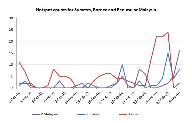
Fig 2G: Hotspot Counts in Sumatra, Borneo and Peninsular Malaysia for October 2015.

3.   Status of El Niño/La Niña

3.1    A strong El Niño prevails in the tropical Pacific Ocean. In October 2015, the sea surface temperatures (SSTs) in the tropical Pacific Ocean (SST) have increased further although the rate of warming has slowed.

3.2    Atmospheric conditions in the ASEAN region are showing a clear response to the strong El Niño conditions. Large-scale drier-than-normal conditions have been observed particularly in the southern and eastern parts of the ASEAN region. A consensus forecast based on international climate models and expert opinion suggests continuation of strong El Niño conditions into early-2016, with the strength of El Niño likely to peak in coming months before decaying.

3.3    Typically the impact of El Niño for the Southeast Asia region is drier than average rainfall conditions, especially in the southern parts of the ASEAN region during June to October. More locally-specific impact differs from place to place and for different seasons.

3.4    The region is now gradually transitioning from the Inter-Monsoon season (Oct – Nov) into the Northeast Monsoon (Dec – Mar). The impact of El Niño is usually less pronounced during the Northeast Monsoon as compared to the Southwest Monsoon (Jun – Sep).

October 16, 2015

Review of Regional Weather and Smoke Haze for Sep 2015

Review of Regional Weather and Smoke Haze for Sep 2015

Print Version

1.   Review of Regional Weather Conditions in September 2015

1.1    The Southwest Monsoon season prevailed in September 2015, with low level winds mainly blowing from the southeast or southwest. The monsoon rain band located close to the northern ASEAN region brought shower activities on most days to parts of the region. In contrast, dry weather conditions in the southern ASEAN region prevailed throughout September 2015.

1.2    Tropical Storm Vamco, which developed on 13 September 2015 over the South China Sea, made landfall south of Danang, Vietnam the next day. Vamco caused flooding and damages particularly to the agriculture and fisheries sectors in Vietnam. The Tropical Storm Vamco continued on its westward track and triggered floods across some provinces in Thailand before gradually dissipating on 18 September.

1.3    The prevailing El Niño conditions continued to have an impact on rainfall activities in the ASEAN region. Below-average rainfall was recorded across most parts of the southern ASEAN region. In the northern ASEAN region, near-average to below-average rainfall was received in the Mekong sub-region. The southern part of Philippines recorded above-average rainfall while below-average rainfall was received in the northern part of Philippines. The regional rainfall distribution for September 2015 is shown in Figure Fig. 1A.


Fig. 1A: Percentage of Normal Rainfall for September 2015


2.   Review of Land/Forest Fires and Smoke Haze Situation

2.1    In September, hotspot activities over the northern ASEAN region were generally subdued by the prevailing wet weather conditions. In contrast, the southern ASEAN region was affected by a prolonged transboundary haze situation in recent years. Persistent hotspot activities were observed especially in the fire-prone provinces of central and southern Sumatra, as well as in Kalimantan throughout the month.

2.2    In September 2015, moderate to dense smoke haze blanketed most parts of the central and southern Sumatra, and West and Central Kalimantan. On most days, the air quality readings in many parts of Sumatra including Jambi were in the hazardous range. Hazardous air quality readings were also reported in Palangkaraya in central Kalimantan and Pontianak in western Kalimantan on a number of days. Visibility was reduced to less than 1 km on most days in Jambi, Pekan Baru and Rengat in Sumatra and in Pontianiak and as the haze situation worsened.

2.3    The moderate to dense smoke haze from the fire-prone provinces in Sumatra and Kalimantan were carried by the prevailing winds to affect the region including Brunei Darussalam, Peninsular Malaysia, Sarawak, Singapore and southern Thailand. Some haze had also spread to the South China Sea and was blown by the prevailing winds to affect some islands in southern Philippines.

2.4    Parts of Peninsular Malaysia, East Malaysia and Singapore were affected by transboundary smoke haze since early September 2015. Air quality was in the Unhealthy and/or Very Unhealthy ranges on most days, and on a few days, the air quality entered into the Hazardous range which resulted in school closures, flight diversions or delayed flights amid poor visibility. On 25 September, the 24-hr PSI in Singapore hit a high of 322. On 26 September, visibility at the Subang Airport deteriorated to below 500 m and the airport was closed for several hours. Air quality readings in Port Klang, Shah Alam and Batu Muda also worsened to Very Unhealthy levels of 224-243 the next day morning.

2.3    In Kuching, Samarahan and Sri Aman, the Air Quality Index (AQI) ranged from ~68-~205, with most days in the Unhealthy to Very Unhealthy range between 9 and 28 September 2015. On 10 September, visibility at the Kuching International Airport deteriorated to below 800m and caused disruptions to flight operations and schedules. Satellite images depicting some of the hotspot activities over the ASEAN region in September 2015 are shown in Figs. 2A to 2E.


Fig. 2A: NOAA-18 satellite image on 2 September shows the central and southern part of Sumatra shrouded in widespread smoke haze. Some smoke haze had spread to the Strait of Malacca and affected the western part of Peninsular Malaysia.

Fig. 2B: AQUA satellite picture on 10 September 2015 shows parts of Kalimantan and Sarawak shrouded in widespread smoke haze. The dense smoke haze was observed mainly over western and central Kalimantan.


Figure 2C: TERRA satellite picture on 13 September 2015 shows widespread moderate to dense smoke haze from Sumatra spreading into the Strait of Malacca and the Peninsular Malaysia.

Fig. 2D: TERRA satellite picture on 24 September 2015 shows central and southern Sumatra covered in widespread dense haze. The dense haze was blown in to the southern part of Peninsular Malaysia by the prevailing southwesterly winds.

Fig. 2E: TERRA satellite picture on 26 September 2015 shows smoke haze from Kalimantan spreads to the South China Sea.


2.3    The hotspot charts for September 2015 for

  1. Cambodia, Myanmar, Thailand, Lao PDR and Vietnam;
  2. Sumatra, Borneo and Peninsular Malaysia; and

are shown in Figs. 2F to 2G respectively


Fig. 2F: Hotspot Counts in Cambodia, Lao PDR, Thailand, Vietnam, Myanmar for September 2015.


Fig 2G: Hotspot Counts in Sumatra, Borneo and Peninsular Malaysia for September 2015.


3.   Status of El Niño/La Niña

3.1    The sea surface temperatures (SSTs) in the tropical Pacific Ocean (SST) have increased further in September 2015. A strong El Niño currently prevails in the tropical Pacific Ocean.

3.2    Atmospheric conditions in the ASEAN region have been showing a clear response to the strong El Niño conditions. Large-scale drier-than-normal conditions have been observed particularly in the southern and eastern parts of the ASEAN region. A consensus forecast based on international climate models and expert opinions suggest the continuation of strong El Niño conditions into early-2016, with the possibility of further strengthening in the coming months.

3.3    Typically the impact of El Niño for the Southeast Asia region is drier than average rainfall conditions, especially in the southern parts of the ASEAN region during June to October. More locally-specific impact differs from place to place and for different seasons.

3.4    The region is now gradually transitioning from the Southwest Monsoon season (Jun-Sep/Oct) into the inter-monsoon period (Oct Nov). El Niño can still have a significant impact on the weather conditions (dryness) over the southern part of ASEAN region, in particular, the western part of the Maritime Continent. With the current El Niño conditions, there is still a risk that the prevailing Aug-Sep-Oct (ASO) season could experience extended periods of drier and warmer conditions in this part of Southeast Asia.

September 8, 2015

Review of Regional Weather and Smoke Haze for Aug 2015

Review of Regional Weather and Smoke Haze for Aug 2015

Print Version

1.   Review of Regional Weather Conditions in August 2015

1.1    The Southwest Monsoon conditions in the region continued to persist in August 2015. In the northern ASEAN region, shower activities prevailed on most days in August 2015. In the southern ASEAN region, the first half of August 2015 experienced wetter than usual weather conditions, in particular around Sumatra, Peninsular Malaysia and Singapore, due to the indirect effects of Super Typhoon Souledor in the northern South China Sea. In the second half of August 2015, dry weather conditions persisted through the period.

1.2    Typhoon Goni, which formed over the western Pacific Ocean near Guam on 14 August, was steered westward towards the Philippines and eventually affected the northern islands of Cagayan province in Luzon Island on 21 August 2015. Typhoon Goni brought strong winds and heavy rains to northern Philippines destroying many homes and displacing many lives along its path. The typhoon clipped through the Philippines and continued on its track northwards before making landfall in the eastern parts of Taiwan on 23 August 2015.

1.3    The prevailing El-Nino conditions continue to bring drier than usual weather conditions over the southern ASEAN region, except in central Sumatra and Peninsular Malaysia where wetter than usual weather conditions were experienced. In the northern ASEAN region, near-average to below-average rainfall was received in the Mekong sub-region. The regional rainfall distribution for August 2015 is shown in Fig. 1A.


Fig. 1A: Percentage of Normal Rainfall for August 2015


2.   Review of Land/Forest Fires and Smoke Haze Situation

2.1    During the review period, hotspot activities in the northern ASEAN region continued to be subdued by shower activities. In contrast, in the southern ASEAN region, following the wet conditions in the first half of the month, a period of extended drier weather contributed to an escalation of hotspot activities for the rest of August 2015. Persistent land and forest fires were observed in central and southern Sumatra, in particular in Jambi and South Sumatra, which lead to widespread moderate to dense smoke haze over many parts of Sumatra.

2.2    Ground observations in Pekan Baru, Jambi and Rengat reported visibility of less than 1 km on several days. In addition, some moderate smoke haze from central Sumatra was observed to spread across the Strait of Malacca to affect Peninsular Malaysia. Several cities along the west coast of Peninsular Malaysia such as Penang and Kuala Lumpur reported low visibilities due to haze and the Air Pollution Index (API) readings were in the high-end of Moderate range.

2.3    In Kalimantan, it was dry with few occurrences of shower activities throughout August 2015. The increased hotspot activities in Kalimantan led to an accumulation of moderate to dense smoke haze especially over western and central Kalimantan. Prevailing southeasterly winds carried the smoke haze towards the northwest to affect Sarawak. On 24 August 2015, there was a deterioration in the air quality in several cities of Sarawak such as Sri Aman and Kuching with the API readings in these cities registering unhealthy levels. In the next few days, the occurrence of showers in Sarawak brought an improvement to the hazy conditions there. Satellite images depicting some of the hotspot activities over the ASEAN region in August 2015 are shown in Figs. 2A to 2E.


Fig. 2A: NOAA-18 satellite image on 11 August shows scattered hotspot activities with moderate to dense smoke haze over many parts of Kalimantan.


Fig. 2B: NOAA-18 satellite picture on 17 August 2015 shows active hotspot activities in Riau and Jambi. Moderate smoke haze was seen to emanate from the hotspots.

Figure 2C: NOAA-18 satellite picture on 17 August 2015 shows widespread moderate to dense smoke haze mainly over central Kalimantan.


Fig. 2D: NOAA-18 satellite picture on 29 August 2015 shows further deterioration of smoke haze situation in Kalimantan as compared to Fig 2A and 2C. New cluster of hotspots with smoke haze also emerged in eastern Kalimantan.

Fig. 2E: NOAA-18 satellite picture on 31 Augusts 2015 shows widespread smoke haze from Sumatra spreading into the Strait of Malacca. The cluster of hotspots in Jambi has been persisting since mid-August.


2.3    The hotspot charts for August 2015 for

  1. Cambodia, Myanmar, Thailand, Lao PDR and Vietnam;
  2. Sumatra, Borneo and Peninsular Malaysia; and

are shown in Figs. 2F to 2G respectively


Fig. 2F: Hotspot Counts in Cambodia, Lao PDR, Thailand, Vietnam, Myanmar for August 2015.


Fig 2G: Hotspot Counts in Sumatra, Borneo and Peninsular Malaysia for August 2015.


3.   Status of El Niño/La Niña

3.1    The sea surface temperatures (SSTs) in the tropical Pacific Ocean (SST) have continued to warm in August 2015. A strong El Niño currently prevails in the tropical Pacific Ocean.

3.2    The rainfall in the Southeast Asia region is showing a clear response to the El Niño development, with observed large-scale drier-than-normal conditions, in particular in the southern and eastern parts of the region. A consensus forecast based on international climate models and expert opinion suggests a high likelihood of the warming of the SST to continue. Further strengthening of El Niño conditions are likely in the coming months, and the El Nino is expected to prevail into early 2016.

3.3    Typically the impact of El Niño for the Southeast Asia region is drier than average rainfall conditions, especially for the southern parts of the ASEAN region during June to October. More locally-specific impact differs from place to place and for different seasons.

3.4    The ASEAN region is currently in the Southwest Monsoon season (June-September/early October), where the El Niño is known to have considerable impact (dryness) on the western part of the Maritime Continent. Thus with the current El Niño conditions, there is a high risk that the Sep-Oct-Nov season could experience extended periods of drier and warmer weather conditions in this part of Southeast Asia.