Monthly Archives: June 2026

June 30, 2026

Review of Regional Weather for May 2026

Review of Regional Weather for May 2026


1. Overview

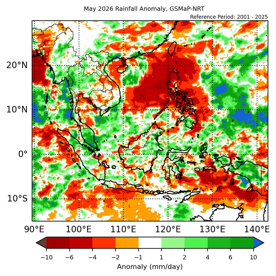
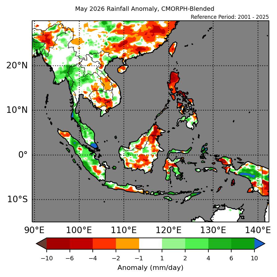
1.1 During May 2026, a mix of near- to above-average rainfall was recorded over most of Mainland Southeast Asia with a mix of below- to above-average rainfall for the Maritime Continent (Figure 1). Parts of southwestern and central Mainland Southeast Asia recorded above-average rainfall based on both datasets (GSMaP-NRT and CMORPH-CRT). The western and southeastern Maritime Continent recorded mostly above-average rainfall, with most of the northeastern part recording below-average rainfall and the central Maritime Continent a mix of below- to above-average rainfall. The largest positive (wetter) anomalies were recorded over the southern Malay Peninsula and Papua for both datasets, with the largest negative (drier) anomalies over the central and northern parts of the Philippines.

1.2 The observed rainfall anomaly pattern of above-average rainfall over southwestern Mainland Southeast Asia to a lesser extent over the southern Malay Peninsula is consistent with the predictions from the subseasonal weather outlooks for May 2026 (27 April – 10 May 2026, 11 – 24 May 2026 and 25 May – 7 June 2026). The wet anomalies over the western Maritime Continent and the dry anomalies over the Philippines are consistent with the seasonal outlook for May 2026, however, the seasonal outlook predicted below-normal rainfall as the dominant tercile for southwestern Mainland Southeast Asia.

era5_rainfall_anomalies
cmorph_bld_rainfall_anomalies
Figure 1: Rainfall anomalies for May 2026 based on GSMaP-NRT data (left) and CPC Global Unified Gauge-based Analysis data (right). The climatological reference period is 2001-2024. Green colour denotes above-average rainfall (wetter), while orange denotes below-average rainfall (drier).


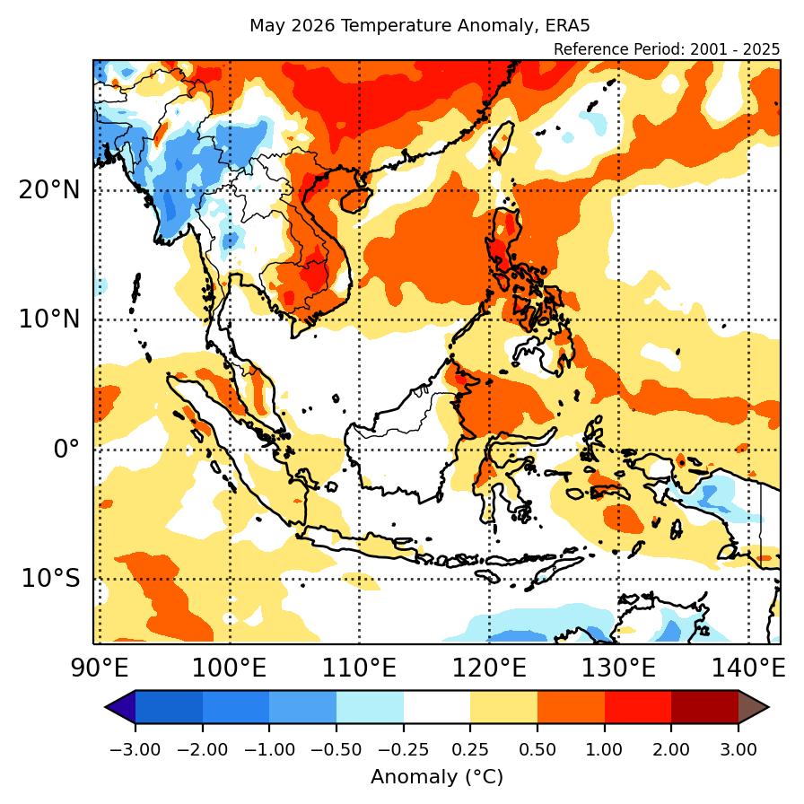
1.3 Above-average temperature was recorded eastern Mainland Southeast Asia, with below- to near-average temperature for northwestern Mainland Southeast Asia (Figure 2). Near-to above-average temperature was recorded for much of the Maritime Continent. The warmest anomalies (1°C – 2°C above average) were recorded over parts of northern Cambodia, southern Lao PDR and northern Philippines. The coolest anomalies (-1°C – -2°C below average) were recorded over parts of central and northern Myanmar. Cooler anomalies (-0.5°C – -1°C below average) were also recoded over central Thailand and Papua.

era5_temperature_anomalies
Figure 2: Temperature anomalies for May 2026 based on ERA-5 reanalysis. The climatological reference period is 2001-2024. Red colour denotes above-average temperature (warmer), while blue denotes below-average temperature (colder).


2. Climate Drivers

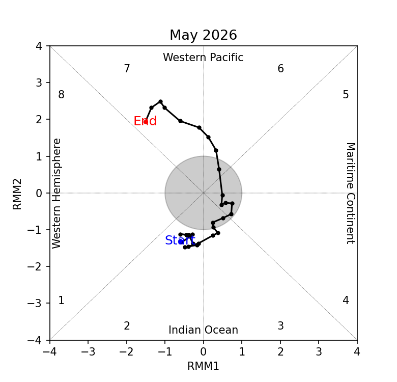
2.1 The Madden-Julian Oscillation (MJO) was active over the Indian Ocean and Western Pacific during much of May. During the first two weeks of May, an MJO signal was present over the Indian Ocean (Phases 2 and 3), before decaying and becoming inactive during the third week of the month. An MJO signal then emerged over the Western Pacific (Phases 6 and 7) in the last week of May. At this time of the year, Phases 2 and 3 tend to bring wetter conditions to the western and central Maritime Continent, with Phases 6 and 7 tending to bring drier conditions to the eastern and central Maritime Continent. This is somewhat in line with wetter conditions over parts of the western Maritime Continent and drier conditions over the northwestern Maritime Continent in Figure 1.

mjo_phase_diagram


Figure 3: The MJO phase diagram. The diagram illustrates the movement of the MJO through different phases, which correspond to different locations along the equator (denoted in the text with the first day of the month in blue and the last day of the month in red). The distance of the index from the centre of the diagram is related to the strength of the MJO. Values within the grey circle are considered weak or indiscernible (data from the Bureau of Meteorology, Australia).


2.2 The El Niño – Southern Oscillation (ENSO) was neutral in April, with the Indian Ocean Dipole (IOD) also in the neutral state.


June 17, 2026

Subseasonal Weather Outlook (22 June – 5 July 2026)

Subseasonal Weather Outlook (22 June – 5 July 2026)

Issued: 17 June 2026
First forecast week: 22 – 28 June 2026
Second forecast week: 29 June – 5 July 2026

figure1

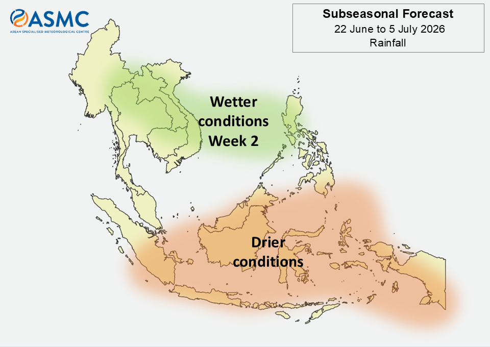
Figure 1: Rainfall Outlook

figure2

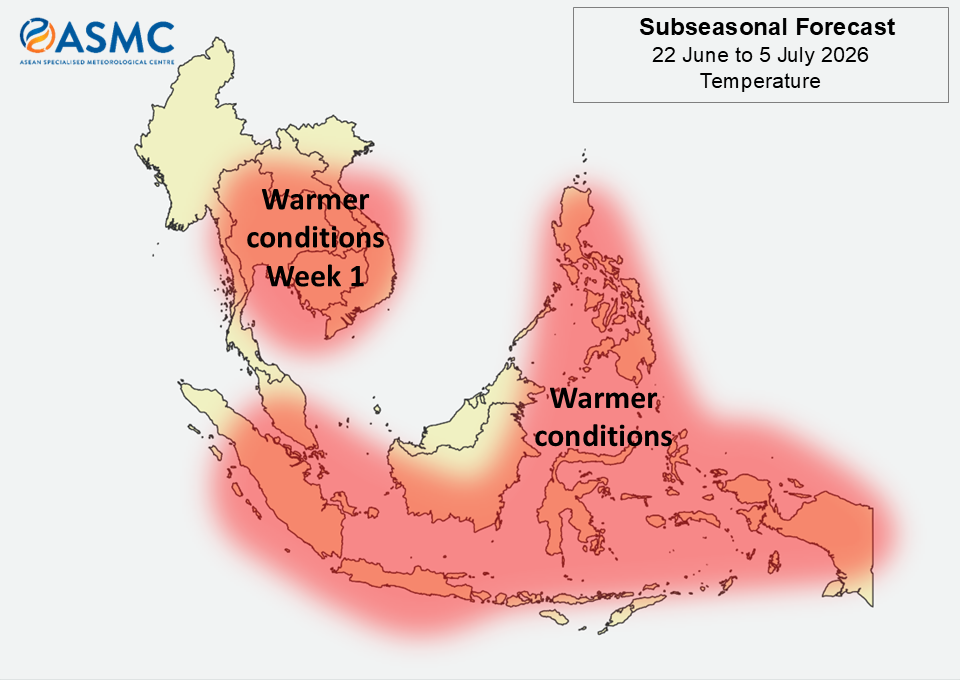
Figure 2: Temperature Outlook

Drier conditions are predicted over most of the equatorial region in the next fortnight (22 June – 5 July). The highest chance of drier conditions is over the central and eastern equatorial region in Week 1 (22 – 28 June), and over the eastern equatorial region in Week 2 (29 June – 5 July).

Wetter conditions are predicted over parts of the northeastern Maritime Continent and much of central and eastern Mainland Southeast Asia in Week 2 (29 June – 5 July).

Warmer than usual temperatures are predicted over most of the Maritime Continent in the next fortnight (22 June – 5 July). Warmer than usual temperatures are also predicted over most of central and eastern Mainland Southeast Asia in Week 1 (22 – 28 June).

A Madden-Julian Oscillation (MJO) signal was present over the Western Hemisphere and Africa (Phase 1) in the middle of June 2026, based on the RMM Index. Most models predict the MJO signal to decay and become indiscernible by the start of the forecast period. Most of these models also predict an emergence of an MJO signal over the Maritime Continent (Phase 5) or the Western Pacific (Phase 6) during the forecast period (22 June – 5 July), with uncertainty in the timing.

The outlook is assessed for the region in general, where conditions are relative to the average conditions for the corresponding time of year. For specific updates on the national scale, the relevant ASEAN National Meteorological and Hydrological Services should be consulted.

June 9, 2026

26th ASEAN COF (May 2026)

Twenty Sixth Session of the ASEAN Climate Outlook Forum (ASEANCOF-26)

image_gallery

19 – 22 May 2026, Online

Consensus Bulletin for June-July-August (JJA) 2026 Season

The ASEAN Climate Outlook Forum (ASEANCOF) is an avenue to collaboratively develop consensus-based seasonal climate outlooks and related information on a regional scale. The forum’s outlook and its activities contribute significantly to one of the key roles of the ASEAN Specialised Meteorological Centre (ASMC), which is to conduct climate and seasonal prediction for the Association of Southeast Asian Nations (ASEAN) region through pooling the expertise of ASEAN National Meteorological and Hydrological Services (NMHSs). In 2021, the ASEANCOF Working Group was established with the goal to guide and support the long-term development of ASEANCOF, in particular regarding the implementation of objective outlooks.

The twenty-sixth session of ASEANCOF (ASEANCOF-26) was organized by the Philippine Atmospheric, Geophysical, and Astronomical Services Administration (PAGASA), Regional Multi-Hazard Early Warning System for Africa and Asia (RIMES), ASMC, the ASEANCOF Working Group, and WMO. This included two prior training sessions: firstly, an introduction to the Seasonal Fundamentals eLearning (pilot version for ASEANCOF) by the UK Met Office; secondly, training and discussion on the Relative Oceanic Niño Index (RONI), by NOAA, Bureau of Meteorology (BoM) Australia, ASMC, and the Meteorological Service Singapore (MSS). During the second training session, participants agreed to adopt RONI alongside other Niño indices for monitoring ENSO in the region.

image_gallery


Conditions and Outlook

Recent sea surface temperature anomalies over the equatorial Pacific Ocean during April-May 2026 overall indicated El Niño–Southern Oscillation (ENSO) neutral conditions were present. However, persistent warming over most of the Niño regions, together with atmospheric indicators such as decreased cloudiness over most parts of Southeast Asia and anomalous low-level westerlies east of the Philippines, supports the development of El Niño-like conditions. Meanwhile, the Indian Ocean remains in a neutral Indian Ocean Dipole (IOD) phase.
International climate outlooks predict a moderate El Niño is likely to develop during June to August (JJA) 2026. After JJA, most models predict continued strengthening into a strong to very strong El Niño, while the rest predict only moderate El Niño conditions to persist through the remainder of the year. If a very strong El Niño occurs, this does not necessarily indicate bigger impacts on Southeast Asia’s climate but rather that typical impacts from El Niño events are more likely to occur. The IOD is also predicted to transition to positive IOD conditions through the latter part of 2026, although with less confidence than the predicted El Niño.
The onset of the 2026 Southwest Monsoon season has been or is expected to be near-average across much of the ASEAN region, except over Viet Nam and the Lao People’s Democratic Republic (PDR), where a later-than-average onset occurred. Overall, the strength of the Southwest Monsoon is predicted to be near or stronger than average over most parts of Southeast Asia.

For JJA 2026, tropical cyclone frequency is predicted to be below- to near-average across the region.

RAINFALL

For the upcoming boreal (Northern Hemisphere) summer season (JJA 2026):

Below-normal rainfall conditions are likely over much of the Maritime Continent, including the southern Philippines, Brunei Darussalam, and Singapore. The exception is over Malaysia, where below- to near-normal or near-normal rainfall is predicted for much of the country, and the central and northern Philippines, where a mix of near- to above-normal rainfall is predicted.
A mix of below- to above-normal rainfall is predicted over mainland Southeast Asia. Below- to near-normal rainfall is predicted over central Thailand, parts of southern Thailand, central Cambodia, and southern Viet Nam. Near-normal rainfall is predicted over the northern half of Myanmar, southern Lao PDR, and mountainous regions of northern Viet Nam and southern Viet Nam. Above-normal rainfall is predicted over coastal and southern Myanmar and parts of northern Lao PDR, with near- to above-normal rainfall over parts of northern Thailand, Cambodia, and Viet Nam.

TEMPERATURE

For the upcoming boreal (Northern Hemisphere) summer season (JJA 2026):

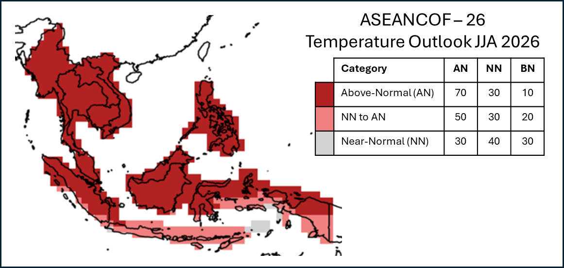
Above-normal temperatures are expected across most parts of Southeast Asia. The exception is over the southern Maritime Continent and parts of northern Viet Nam and northern, southern, and coastal Myanmar, where near- to above-normal temperatures are predicted.

1For this outlook, near-to above-normal temperature corresponds to 50% probability of above-normal temperature, 40% near-normal, and 10% below-normal. Further information is in the consensus maps.

Refer to Annex A for reference on what is meant by “above, near, or below normal” in the outlook. For more information on the boreal (Northern Hemisphere) summer monsoon outlook and further updates on the national scale, the relevant NMHSs should be consulted (see Annex B).

CONSENSUS MAPS FOR JJA 2026

The following maps provide the probabilistic outlooks for the JJA 2026 season in terms of tercile categories of “Above Normal” (AN: upper tercile), “Near Normal” (NN: middle tercile), and “Below Normal” (BN: lower tercile).

PROBABILISTIC RAINFALL OUTLOOK
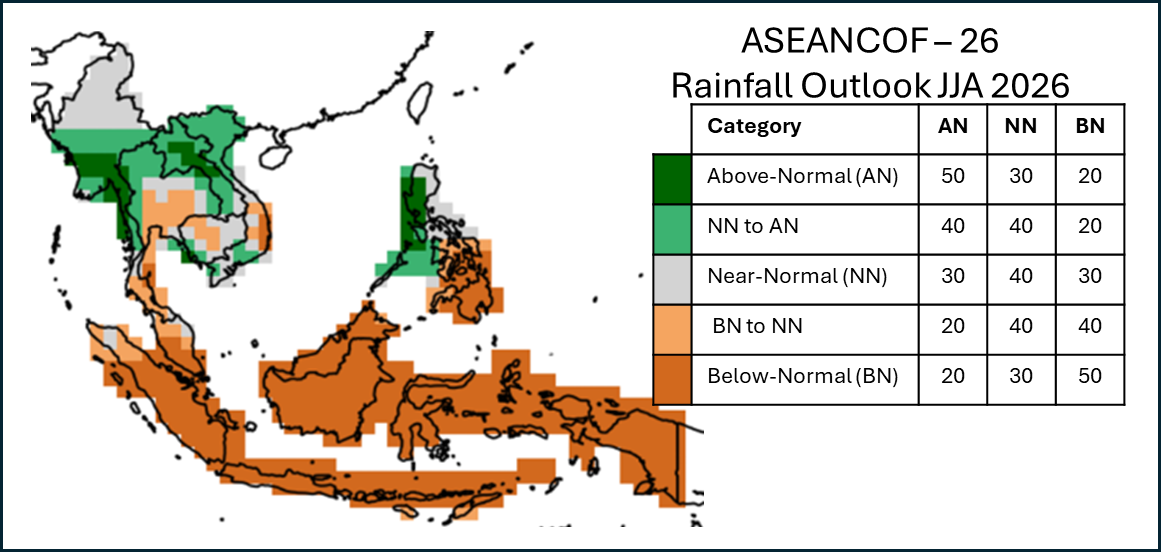
image007

PROBABILISTIC TEMPERATURE OUTLOOK

image008

Meeting Documents

ASEANCOF-26 Outlook Bulletin

Acknowledgements

ASEANCOF-26 would like to express appreciation to the NMHSs of the ASEAN Member States for sharing their national level forecasts, the Global Producing Centres (GPCs: Japan Meteorological Administration (JMA), NOAA, BoM, China Meteorological Administration (CMA), European Centre for Medium-range Weather Forecasts (ECMWF), UK Met Office, APEC Climate Centre (APCC)), the Southeast Asia Regional Climate Centre (SEA-RCC)-Network, RIMES, UN ESCAP, FAO, and other partners of ASEANCOF for sharing their products and expertise, and the WMO Regional Office in Asia and the Pacific (RAP) for their continued support of ASEANCOF. The forum would also like to thank PAGASA for hosting and facilitating the online forum.
June 8, 2026

ASMC Annual Report 2025/2026

ASMC Annual Report 2025/2026

Review of Regional Haze Situation for May 2026

Review of Regional Haze Situation for May 2026

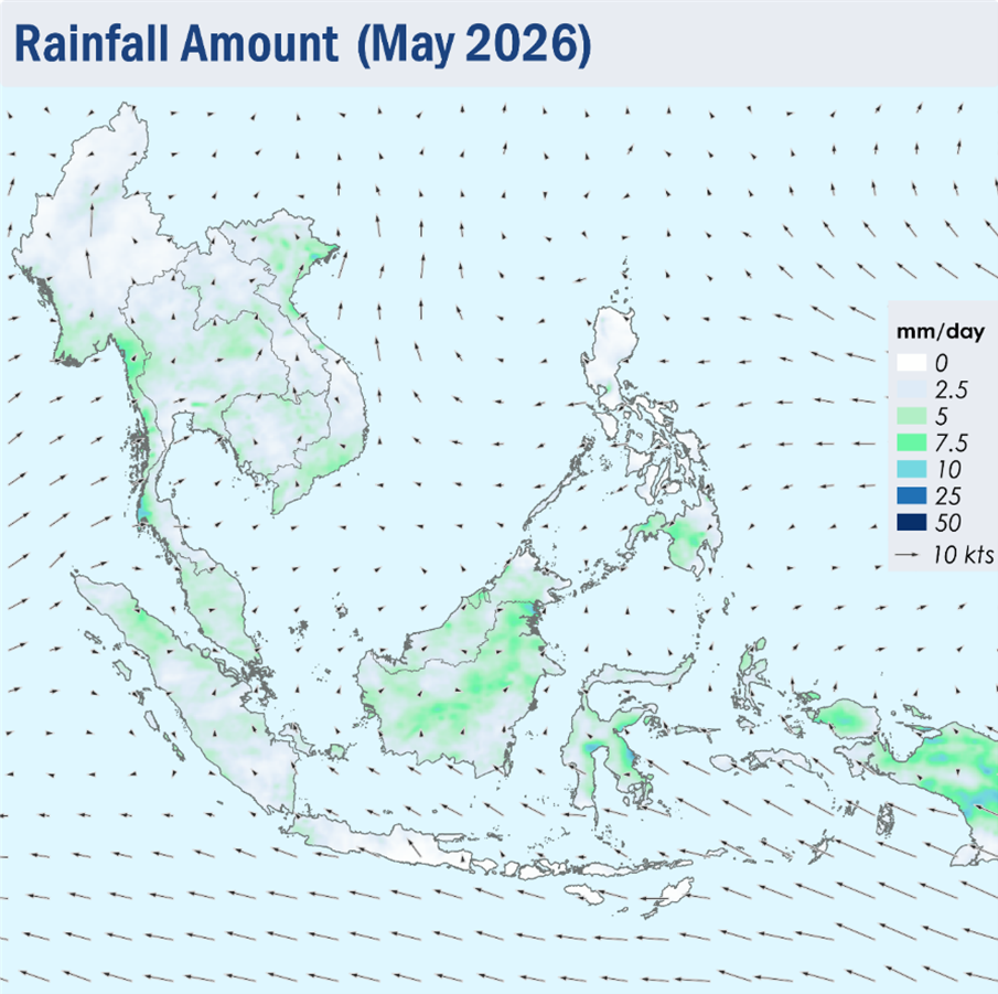
1.1 Light and variable winds were observed over many parts of the ASEAN region during the review period of May 2026 (Figure 1). Over the Mekong sub-region, the prevailing winds were mostly light and southerly, while southeasterly winds continued to dominate over Java, Sulawesi and the Lesser Sunda Islands.

1.2 Overall, the ASEAN region experienced wet weather during the review period as the monsoon rainband shifted northwards and was situated over the area near the Equator. The Alert Level for the Mekong sub-region was downgraded to Level 0 on 14 May 2026 following the increase in showers and the expected persistent rainfall over the sub-region. The southern ASEAN region continued to experience wet weather, except for drier conditions over Java and the Lesser Sunda Islands.

Figure 1: Average Daily Rainfall and Mean Winds for May 2026. (Source: JAXA GsMaP and GFS, respectively)

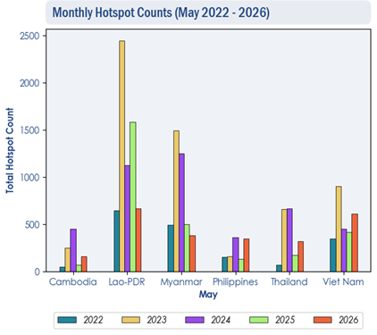
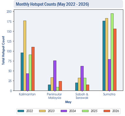
1.3 Hotspot counts in the ASEAN region were generally comparable to the previous years.

Figure 2: Hotspot counts for the northern ASEAN region for May (2022-2026) based on NOAA-20 satellite surveillance.

Figure 3: Hotspot counts for the southern ASEAN region for May (2022-2026) based on NOAA-20 satellite surveillance.

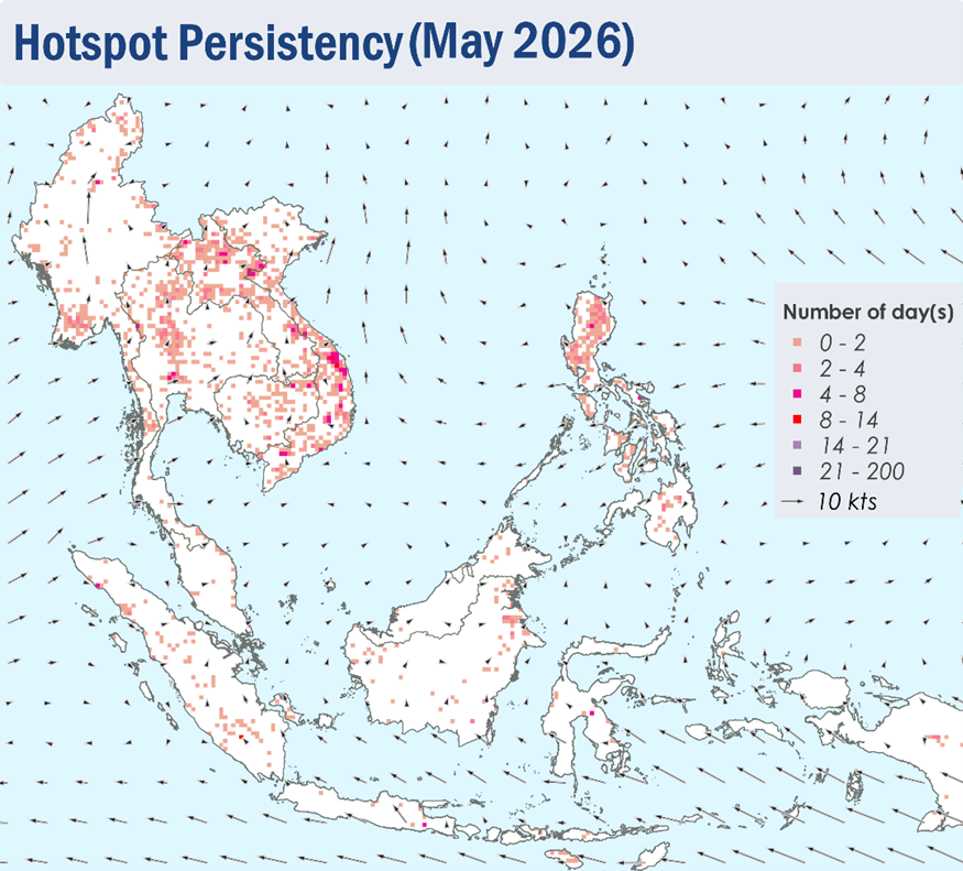
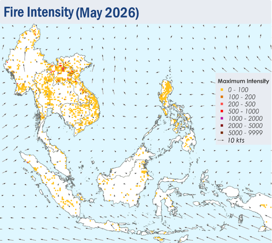
1.4 Isolated hotspots were detected in the northern ASEAN region, particularly in the northern parts of Lao PDR and the central parts of Viet Nam where hotspots are more intense and persistent.

1.5 For the southern ASEAN region, a few to isolated hotspots were mostly detected in parts of Sumatra, Borneo and Peninsular Malaysia.

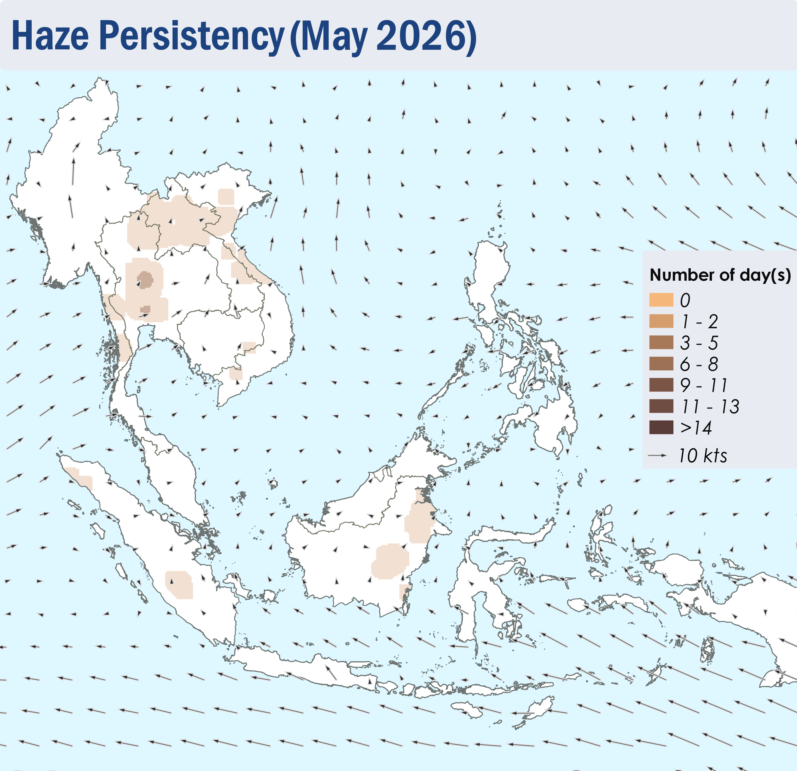
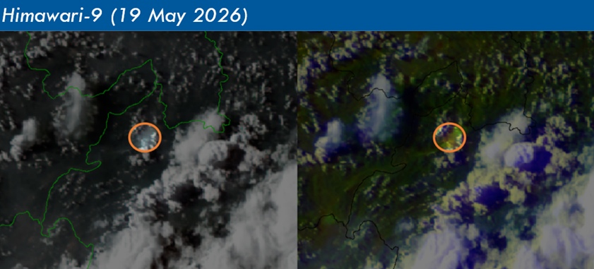
1.6 During the first half of May 2026, slight to moderate smoke haze was observed over the southern parts of Myanmar and the northern and central parts of Thailand. Localised smoke plumes were also occasionally observed over the parts of Kalimantan in mid-May, as well as parts of Sumatra and the northern parts of Lao PDR and Viet Nam in the later half of the review period.

Figure 4: Distribution of hotspots detected in May 2026 based on NOAA-20 satellite surveillance.

Figure 5: Maximum fire intensity in May 2026 based on NOAA-20 satellite surveillance.

Figure 6: Number of days with moderate to dense smoke haze observed in May 2026 based on satellite imagery, ground observations, and air quality reports.

Figure 7: Slight to moderate localised smoke plumes observed over northern Lao PDR on 19 May 2026. (Source: Himawari-9 satellite surveillance)

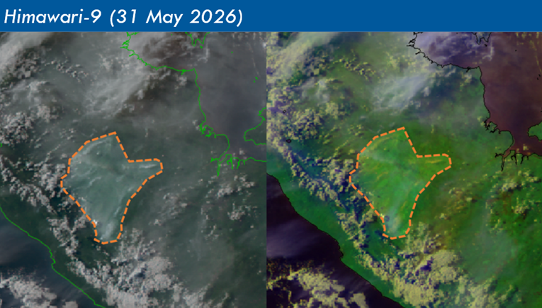
Figure 8: Slight and localised smoke plumes observed over the southern parts of Sumatra on 31 May 2026. (Source: Himawari-9 satellite surveillance)

June 4, 2026

Subseasonal Weather Outlook (8 – 21 June 2026)

Subseasonal Weather Outlook (8 – 21 June 2026)

Issued: 3 June 2026
First forecast week: 8 – 14 June 2026
Second forecast week: 15 – 21 June 2026

figure1

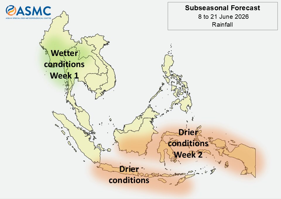
Figure 1: Rainfall Outlook

figure2

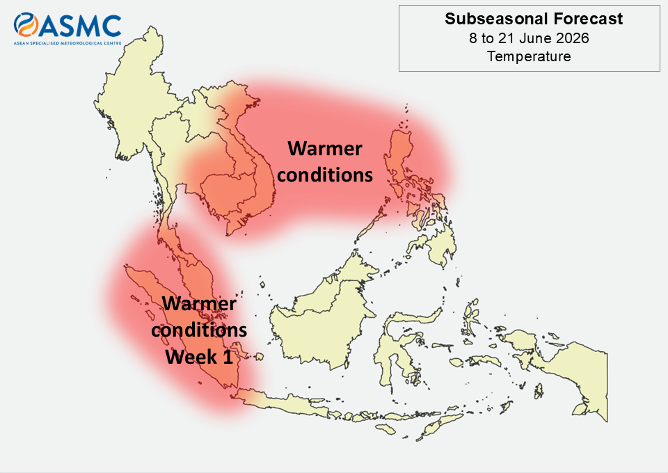
Figure 2: Temperature Outlook

Wetter conditions are predicted over much of western and northern Mainland Southeast Asia in Week 1 (8 – 14 June).

Drier conditions are predicted over the southern Maritime Continent during the next fortnight (8 – 21 June). Drier conditions are also predicted over much of the central and eastern equatorial region in Week 2 (15 – 21 June).

Warmer than usual temperatures are predicted over the western Maritime Continent in Week 1 (8 – 14 June). Warmer than usual temperatures are also predicted over eastern Mainland Southeast Asia and parts of the northeastern Maritime Continent during the next fortnight (8 – 21 June).

A Madden-Julian Oscillation (MJO) signal was present over the Western Pacific (Phase 7) at the start of June 2026, based on the RMM Index. Most models predict the MJO signal to propagate to the Western Hemisphere and Africa (Phase 8) and weaken, becoming indiscernible either by the start of the forecast period or in Week 1 (8 – 14 June). No significant MJO activity is predicted for Week 2 (15 – 21 June).

The outlook is assessed for the region in general, where conditions are relative to the average conditions for the corresponding time of year. For specific updates on the national scale, the relevant ASEAN National Meteorological and Hydrological Services should be consulted.