Category Archives: Fortnightly Weather Review

CR58

May 23, 2019

Review of Regional Weather Conditions for First Fortnight of May 2019

Review of Regional Weather Conditions for First Fortnight of May 2019

Print Version

1. Review of Regional Weather Conditions for First Fortnight of May 2019

1.1 Under inter-monsoon conditions, the prevailing winds over the equatorial region were mostly light and variable in direction over the past fortnight. Over the northern ASEAN region, there were anomalous westerly winds (Figure 1).

fig1a_fn1
fig1b_fn1
Figure 1 5000 ft average winds (left) and anomalies (right) for 1 – 15 May 2019 (Source: JMA)
fig1_fn1

Figure 2: Daily average rainfall for the ASEAN region in the first fortnight of May 2019. (Source: JAXA Global Satellite Mapping of Precipitation)
fig1_fn1

Figure 3: Percentage of average rainfall for 1 – 15 May 2019. The rainfall data may be less representative for areas with a less dense rainfall network. (Source: IRI NOAA/NCEP CPC Unified Precipitation Analyses)

1.2 There were scattered showers over the region in the first half of May (Figure 2), with the exception of Myanmar where generally dry weather prevailed. Myanmar and the northern parts of Lao PDR and Thailand received below-average rainfall, which could have been due to dry air from the Bay of Bengal that persisted over these areas early in the month. Many areas along the equatorial region (including southern parts of Peninsular Malaysia, Sumatra, and Borneo) received below-normal rainfall (Figure 3), and this could in part be attributed to the Madden-Julian Oscillation (MJO) activities from Phase 5 to Phase 8 during the fortnight.

Figure 4: The MJO phase diagram for March 2019-May 2019 (green for April). The diagram illustrates the movement of the MJO through different phases, which correspond to different locations along the equator. The distance of the index from the centre of the diagram is correlated with the strength of MJO. When the index falls within the circle, the MJO is considered weak or indiscernible. (Source: Bureau of Meteorology)

1.3 In the first half of May, although there was a slight cooling of the sea surface, the sea surface temperatures of the equatorial Pacific Ocean remained warmer than average. There was no consistent coupling between the sea surface temperatures and the atmosphere, indicating that full-fledged El Niño conditions have not developed.

April 24, 2019

Review of Regional Weather Conditions for First Fortnight of April 2019

Review of Regional Weather Conditions for First Fortnight of April 2019

Print Version

1. Review of Regional Weather Conditions for First Fortnight of April 2019

1.1 The ASEAN region is under the influence of inter-monsoon conditions. Southwesterly or westerly winds prevailed over the Mekong sub-region, with Myanmar experiencing stronger-than-usual westerly winds along the coast. Winds were generally weak in the southern ASEAN region, except for the area around Papua and south of Kalimantan where there were stronger-than-usual westerly or northwesterly winds due to Typhoon Wallace and a developing low pressure system in the Timor Sea.

figure1b_aprfn1

Figure 1: 5000 ft average winds (left) and anomalies (right) for 1 – 15 April 2019. (Source: JMA)

1.2 Inter-monsoon conditions contributed to an increase in showers compared to March 2019 over the northern ASEAN region. However, dry weather continued to persist over many areas in Myanmar, northern Thailand and northern Lao PDR.

1.3 In the southern ASEAN region, showers fell over many parts of the region. Drier-than-average conditions were observed over northern Sumatra, east coast of Peninsular Malaysia, Sabah, Sarawak, and West Kalimantan.

figure1_aprfn1

Figure 2: Daily average rainfall for the ASEAN region in the First Fortnight of April 2019. (Source: JAXA Global Satellite Mapping of Precipitation)

Figure 3: Percent of average rainfall for 1 – 15 April 2019. The rainfall data may be less representative for areas with a less dense rainfall network. Hatched areas indicate climatology dry mask (average daily rainfall below 1 mm). (Source: IRI NOAA/NCEP CPC Unified Precipitation Analyses)

1.4 The Madden-Julian Oscillation (MJO) signal remained weak during the first fortnight of April 2019 and had no significant influence on the weather over the ASEAN region (Figure 4).

Figure 4: The MJO phase diagram (blue for April 2019). The diagram illustrates the movement of the MJO through different phases, which correspond to different locations along the equator. The distance of the index from the centre of the diagram is correlated with the strength of MJO. When the index falls within the circle, the MJO is considered weak or indiscernible. (Source: Bureau of Meteorology)

1.5 The sea surface temperatures over the tropical Pacific Ocean Nino 3.4 region remained warm and close to El Niño thresholds. However, other indicators of El Niño Southern Oscillation such as the strength of trade winds and sea level pressure difference between the eastern and western tropical Pacific Ocean were close to normal.

April 13, 2019

Review of Regional Weather Conditions for Second Fortnight of March 2019

Review of Regional Weather Conditions for Second Fortnight of March 2019

Print Version

1. Review of Regional Weather Conditions for Second Fortnight of March 2019

1.1 The Northeast Monsoon season gradually weakened and transitioned to inter-monsoon conditions in the second fortnight of March 2019. The prevailing winds over the Mekong sub-region were generally weak and variable in direction, while that in the southern ASEAN region, were blowing from the southwest and northwest. Over Java, there were westerly and southwesterly anomalies due to low pressure systems that developed south of Java during the fortnight. Figure 1 shows the average and anomalous winds at 5000 feet.

figure3b_febfn1

Figure 1: 5000 ft average winds (left) and anomalies (right) for 16 – 31 March 2019. (Source: JMA)

1.2 The transition to inter-monsoon conditions during the latter part of the fortnight brought an increase in rainfall over southern parts of the Mekong sub-region. However, dry conditions prevailed over Myanmar, and the northern parts of Lao PDR and Thailand (Figure 2). In the southern ASEAN region, areas along the equatorial region, including southern Thailand, Peninsular Malaysia, Sarawak, northern and central Sumatra and West Kalimantan received below-average rainfall under the influence of a persistent dry air mass extending from the Pacific Ocean over the Southeast Asia region (Figure 3).

figure1_febfn1

Figure 2: Daily average rainfall for the ASEAN region in the second fortnight of March 2019. (Source: JAXA Global Satellite Mapping of Precipitation)

Figure 3: Percent of average rainfall for 16 – 31 March 2019. The rainfall data may be less representative for areas with a less dense rainfall network. Hatched areas indicate climatology dry mask (average daily rainfall below 1 mm). (Source: IRI NOAA/NCEP CPC Unified Precipitation Analyses)

1.3 The Madden-Julian Oscillation (MJO) signal remained weak during the second fortnight of March 2019 and had no significant influence on the weather over the ASEAN region (Figure 4).

Figure 4: The MJO phase diagram (green for March 2019). The diagram illustrates the movement of the MJO through different phases, which correspond to different locations along the equator. The distance of the index from the centre of the diagram is correlated with the strength of MJO. When the index falls within the circle, the MJO is considered weak or indiscernible. (Source: Bureau of Meteorology)

1.4 The sea surface temperatures over the tropical Pacific Ocean Nino 3.4 region were warm and close to the El Niño thresholds. However, there was little atmospheric response observed, such as the lack of consistent weaker-than-average trade winds and large-scale rainfall patterns over the tropical Pacific.

March 26, 2019

Review of Regional Weather Conditions for First Fortnight of March 2019

Review of Regional Weather Conditions for First Fortnight of March 2019

Print Version

1. Review of Regional Weather Conditions for First Fortnight of March 2019

1.1 In the first fortnight of March 2019, northeasterly winds prevailed over the Philippines and the southern ASEAN region, while winds over the Mekong sub-region were light and blew mainly from the southwest. No significant wind anomalies were observed over the ASEAN region during this period. There was a gradual weakening of the northeasterly monsoonal winds during the first fortnight of the month.

figure3b_febfn1

Figure 1: 5000 ft average winds (left) and anomalies (right) for 1 – 15 March 2019. (Source: JMA)

1.2 The dry air mass that has been extending from the Pacific Ocean to the Southeast Asia region since late-January continued to bring persistent dry weather over the northern ASEAN region, as well as over parts of Peninsular Malaysia, northern and central Sumatra, and northern Borneo in the first half of March 2019. Rainfall was below-average for these areas.

1.3 In the first fortnight of March 2019, most of the rainfall fell over areas south of the equator (Figure 2). Rainfall was near-average to above-average for areas including southern Sumatra, Kalimantan, Java and the eastern archipelago of Indonesia (Figure 3).

figure1_febfn1

Figure 2: Daily average rainfall for the ASEAN region in the first fortnight of March 2019. (Source: JAXA Global Satellite Mapping of Precipitation)

Figure 3: Percent of average rainfall for 1 – 15 March 2019. The rainfall data may be less representative for areas with a less dense rainfall network. Hatched areas indicate climatology dry mask (average daily rainfall below 1 mm). (Source: IRI NOAA/NCEP CPC Unified Precipitation Analyses)

1.4 The Madden-Julian Oscillation (MJO) propagated through Phase 2 – 3 and contributed to increased rainfall activities observed over areas south of the equator, including southern Sumatra, Java and the eastern archipelago of Indonesia. Towards the end of the fortnight, the MJO reached Phase 4, where it rapidly weakened.

Figure 4: The MJO phase diagram (green for March 2019). The diagram illustrates the movement of the MJO through different phases, which correspond to different locations along the equator. The distance of the index from the centre of the diagram is correlated with the strength of MJO. When the index falls within the circle, the MJO is considered weak or indiscernible. (Source: Bureau of Meteorology)

1.5 Slightly warm sea surface temperature anomalies over the Pacific Ocean are nearing El Niño levels. Sub-surface waters have become warmer than average. Nonetheless, there remained a lack of atmosphere-ocean coupling as atmospheric conditions remained largely neutral and inconsistent with El Nino conditions.

March 8, 2019

Review of Regional Weather Conditions for Second Fortnight of February 2019

Review of Regional Weather Conditions for Second Fortnight of February 2019

Print Version

1. Review of Regional Weather Conditions for Second Fortnight of February 2019

1.1 Northeast Monsoon conditions persisted over the ASEAN region in the second half of February 2019. Northeasterly or easterly winds prevailed over the Philippines, southern Thailand and most parts of the southern ASEAN region. Over the Mekong sub-region, prevailing winds were generally blowing from the southeast or southwest, with confluence of winds over parts of the Mekong sub-region.

figure3b_febfn1

Figure 1: 5000 ft average winds (left) and anomalies (right) for 16 – 28 February 2019. (Source: JMA)

1.2 A confluence of winds typically favours shower activity development, but weather over the Mekong sub-region remained dry mainly due to the presence of dry air mass that has extended from the Pacific Ocean over the Southeast Asia region. Elsewhere in the ASEAN region, rainfall distribution over the fortnight was also likely associated with the Madden – Julian Oscillation (MJO) which transitioned from phase 8 to phase 2 . Well below-average rainfall was recorded in the Philippines, Peninsular Malaysia, Sabah, western Kalimantan and parts of Java, while above-average rainfall was received in other parts of the southern ASEAN region.

figure1_febfn1

Figure 2: Daily average rainfall for the ASEAN region in the second fortnight of February 2019. (Source: JAXA Global Satellite Mapping of Precipitation)

Figure 3: Percent of average rainfall for 16 – 28 February 2019. The rainfall data may be less representative for areas with a less dense rainfall network. Hatched areas indicate climatology dry mask (average daily rainfall below 1 mm). (Source: IRI NOAA/NCEP CPC Unified Precipitation Analyses)

Figure 4: The MJO phase diagram (green for February 2019). The diagram illustrates the movement of the MJO through different phases, which correspond to different locations along the equator. The distance of the index from the centre of the diagram is correlated with the strength of MJO. When the index falls within the circle, the MJO is considered weak or indiscernible. (Source: Bureau of Meteorology)

February 23, 2019

Review of Regional Weather Conditions for First Fortnight of February 2019

Review of Regional Weather Conditions for First Fortnight of February 2019

Print Version

1. Review of Regional Weather Conditions for First Fortnight of February 2019

1.1 Northeast Monsoon conditions prevailed over the ASEAN region during the first fortnight of February 2019.

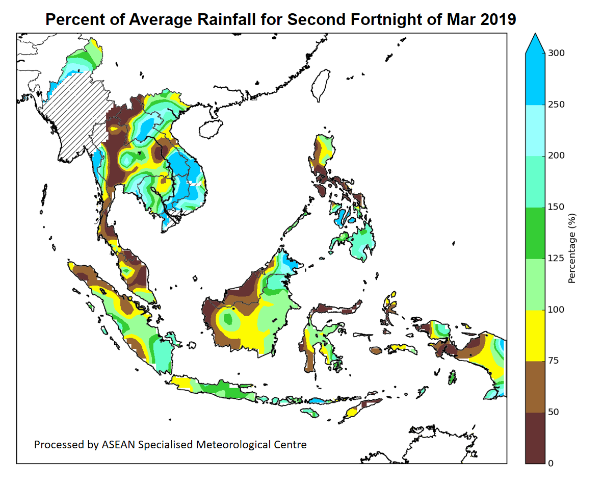
1.2 The Mekong sub-region continued to experience dry conditions, which is typical over the region during this period. The dry conditions were exacerbated by the influence of an extensive dry air mass over the northern ASEAN region. Pockets of drier than usual conditions were observed mainly over parts of Viet Nam, and the eastern and southern parts of Thailand. The Philippines also observed below-average rainfall due to the influence of the dry air mass.

1.3 In the southern ASEAN region, scattered showers fell over most parts of the region. However, well below-average rainfall was recorded around the equatorial region over northern Sumatra, East Kalimantan, Singapore and most parts of Malaysia. This drier than normal conditions were partly due to the southward extension of the dry air mass from the northern ASEAN region. Elsewhere in the southern ASEAN region, above-average rainfall was observed.

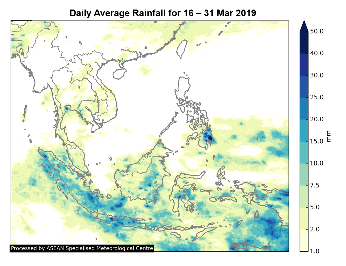
1.4 The rainfall distribution and the percent of average rainfall for the first fortnight of February 2019 are shown in Figure 1 and 2.

figure1_febfn1

Figure 1: Daily average rainfall for the ASEAN region in the first fortnight of February 2019. (Source: JAXA Global Satellite Mapping of Precipitation)

Figure 2: Percent of average rainfall for 1 – 15 February 2019. The rainfall data may be less representative for areas with a less dense rainfall network. Hatched areas indicate climatology dry mask (average daily rainfall below 1 mm). (Source: IRI NOAA/NCEP CPC Unified Precipitation Analyses)

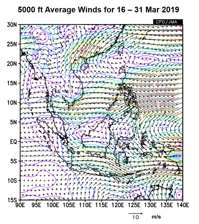
1.5 During the fortnight, prevailing winds in the northern ASEAN region were generally blowing from the northeast or east, except for Myanmar where the winds were from the southwest or west. In the southern ASEAN region, westerly or northwesterly winds prevailed, except for the region west of southern Sumatra where southeasterly anomalies were observed.

figure3a_febfn1

figure3b_febfn1

Figure 3: 5000 ft average winds (left) and anomalies (right) for 1 – 15 February 2019. (Source: JMA)

1.6 The El Niño Southern Oscillation (ENSO) continued to remain neutral (neither El Niño nor La Niña). However, the sea surface temperatures (SSTs) over the tropical Pacific Ocean was observed to have warmed slightly during the fortnight, aided by the westerly wind anomalies in the presence of the MJO. Consequently, trade winds in the western Pacific Ocean were also observed to have weaken.

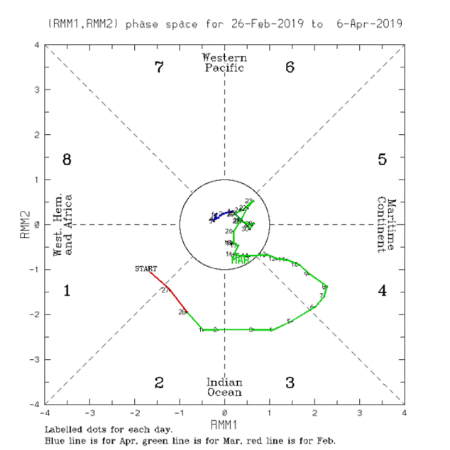
1.7 During the fortnight, the MJO propagated through Phase 7 – 8. The MJO in Phases 7 and 8 usually brings drier conditions over most parts of the southern ASEAN region and equatorial South China Sea. During this period, the MJO might have contributed to the drier conditions over the equatorial region.

Figure 4: The MJO phase diagram for Feb 2019 (blue). The diagram illustrates the movement of the MJO through different phases, which correspond to different locations along the equator. The distance of the index from the centre of the diagram is correlated with the strength of MJO. When the index falls within the circle, the MJO is considered weak or indiscernible. (Source: Bureau of Meteorology)

January 30, 2019

Review of Regional Weather Conditions for First Fortnight of January 2019

Review of Regional Weather Conditions for First Fortnight of January 2019

Print Version

1. Review of Regional Weather Conditions for First Fortnight of January 2019

1.1 Northeast Monsoon conditions prevailed over the ASEAN region. In the Mekong sub-region, dry weather persisted over most parts of the region, except for some isolated showers that fell over coastal Viet Nam on a few days due to the strengthening of northeasterly and easterly winds over the South China Sea. Rainy conditions were also experienced in southern Thailand and northern Peninsular Malaysia due to the passage of Typhoon Pabuk during the first week of the month. This resulted in above-average rainfall over southern Thailand and northern Peninsular Malaysia.

1.2 There were scattered shower activities over the southern ASEAN region, and most parts of the region received average to above-average rainfall. However, there were some areas where below-average rainfall was received, namely parts of Malaysia, northern Sumatra, and Java.

1.3 The rainfall distribution and the percent of average rainfall for the first fortnight of January 2019 are shown in Figure 1 and 2.

figure1_JanFN1

Figure 1: Daily average rainfall for the ASEAN region in the first fortnight of January 2019. (Source: JAXA Global Satellite Mapping of Precipitation)

Figure 2: Percent of average rainfall for 1 – 15 January 2019. The rainfall data may be less representative for areas with a less dense rainfall network. Hatched areas indicate climatology dry mask (average daily rainfall below 1 mm). (Source: IRI NOAA/NCEP CPC Unified Precipitation Analyses)

1.4 In the northern ASEAN region, moderate to strong easterly winds prevailed over the South China Sea area. There were also anomalously southwesterly winds under the influence of the Typhoon Pabuk. In the southern ASEAN region, anomalous westerly winds were recorded.

figure3a_Janfn1

figure3b_Janfn1

Figure 3: 5000 ft average winds (left) and anomalies (right) for 1 – 15 January 2019. (Source: JMA)

figure3_fn2

Figure 4: Track of Typhoon Pabuk between 1 and 6 January 2019.

1.5 The sea surface temperature (SST) over the tropical Pacific Ocean is warmer than average, but temperatures remained in weak El Nino conditions and have weakened further. Prevailing atmospheric response, viz the cloudiness and trade winds over the tropical Pacific Ocean have remained neutral.
1.6 During the fortnight, moderate to strong Madden Julian Oscillation (MJO) signals propagated through Phase 6 – 8. The signal weakened towards the end of the second week of the fortnight. Although MJO signals in Phase 6 – 8 typically brought dry weather to the region, the MJO did not significantly influenced the weather in Southeast Asia during this period.

Figure 5: The MJO phase diagram for Jan 2019 (blue). The diagram illustrates the movement of the MJO through different phases, which correspond to different locations along the equator. The distance of the index from the centre of the diagram is correlated with the strength of MJO. When the index falls within the circle, the MJO is considered weak or indiscernible. (Source: Bureau of Meteorology)

January 18, 2019

Review of Regional Weather Conditions for Second Fortnight of December 2018

Review of Regional Weather Conditions for Second Fortnight of December 2018

Print Version

1. Review of Regional Weather Conditions for Second Fortnight of December 2018

1.1 Northeast Monsoon conditions prevailed over the ASEAN region in the second fortnight of December 2018. Dry weather persisted over the Mekong sub-region, and there were occasional dry periods in parts of Sumatra and Peninsular Malaysia. Rainfall was above-average over the Philippines, and below- to near-average in the southern ASEAN region.

1.2 The rainfall distribution and the percent of average rainfall for the second fortnight of December 2018 are shown in Figure 1 and 2.

figure1_OctFN2

Figure 1: Daily average rainfall for the ASEAN region in the second fortnight of December 2018. (Source: JAXA Global Satellite Mapping of Precipitation)

Figure 2: Percent of average rainfall for 16 – 31 December 2018. The rainfall data may be less representative for areas with a less dense rainfall network. Hatched areas indicate climatology dry mask (average daily rainfall below 1 mm). (Source: IRI NOAA/NCEP CPC Unified Precipitation Analyses)

1.3 Moderate to strong north-easterly winds prevailed over the northern ASEAN region while in the southern ASEAN region, winds were generally blowing from the west or north-west. During the period, there were westerly wind anomalies over the equatorial ASEAN region.

figure3_fn2

figure3_fn2

Figure 4: 5000 ft average winds (left) and anomalies (right) for 16 – 31 December 2018. (Source: JMA)

1.4 The tropical Pacific Ocean’s sea surface temperature (SST) anomalies over the Nino3.4 region continue to be above El Niño threshold. However, most of the atmospheric indicators of El Niño/La Niña over the tropical Pacific remained neutral. Without the atmosphere-ocean coupling, El Niño has yet to be fully establish.

Figure 5: The MJO phase diagram for Nov – Dec 2018 (blue for December). The diagram illustrates the movement of the MJO through different phases, which correspond to different locations along the equator. The distance of the index from the centre of the diagram is correlated with the strength of MJO. When the index falls within the circle, the MJO is considered weak or indiscernible. (Source: Bureau of Meteorology)

1.5 There were moderate to strong Madden Julian Oscillation (MJO) signals, which propagated through Phase 4 – 5 during the review period. The MJO signals were consistent with the eastward shift of the rainfall pattern and the westerly wind anomalies observed in the region.

December 21, 2018

Review of Regional Weather Conditions for First Fortnight of December 2018

Review of Regional Weather Conditions for First Fortnight of December 2018

Print Version

1. Review of Regional Weather Conditions for First Fortnight of December 2018

1.1 Northeast Monsoon conditions prevailed over the ASEAN region in the first half of December 2018. In the northern ASEAN region, weather was generally dry. Prevailing winds blew mainly from the northeast or east in general except in Myanmar, where winds were more variable. In the southern ASEAN region, winds were generally light and variable except for the moderate to strong northeasterly winds over parts of Malaysia. Confluence of winds along the equatorial region gave rise to rainy weather and above-average rainfall in many areas.

1.2 The daily average rainfall and the percentage of average rainfall for the first fortnight of December 2018 are shown in Figures 1 and 2 respectively. The 5000ft average winds and wind anomalies in the first half of December 2018 are shown in Figures 3 and 4 respectively.

figure1_OctFN2

Figure 1: Daily average rainfall for the ASEAN region in the first fortnight of December 2018. (Source: JAXA Global Satellite Mapping of Precipitation)

Figure 2: Percentage of Average Rainfall for 1 – 15 December 2018. The rainfall data may be less representative for areas with a less dense rainfall network. (Source: IRI NOAA/NCEP CPC Unified Precipitation Analyses)

figure3_fn2

figure3_fn2

Figure 4: 5000 ft average winds (left) and anomalies (right) for 1 – 15 December 2018. (Source: JMA)

1.3 The Madden – Julian Oscillation (MJO) transitioned from Phase 8 to Phase 4 in the first half of December 2018, with slightly stronger amplitude of signals registered in Phase 2 to Phase 4. The stronger MJO activities in Phase 2 to Phase 4 are also associated with the rainy conditions experienced in the Indian Ocean and many parts of the southern ASEAN region.

Figure 5: The MJO phase diagram for Nov – Dec 2018 (blue for December). The diagram illustrates the movement of the MJO through different phases, which correspond to different locations along the equator. The distance of the index from the centre of the diagram is correlated with the strength of MJO. When the index falls within the circle, the MJO is considered weak or indiscernible. (Source: Bureau of Meteorology)

1.6 Although above-average sea surface temperatures persisted across the equatorial Pacific Ocean, the atmospheric indicators of El Niño – Southern Oscillation (ENSO) remained close to average. Sustained El-Niño conditions have yet been established.

December 13, 2018

Review of Regional Weather Conditions for Second Fortnight of November 2018

Review of Regional Weather Conditions for Second Fortnight of November 2018

Print Version

1. Review of Regional Weather Conditions for Second Fortnight of November 2018

1.1 Under prevailing Northeast Monsoon conditions, dry conditions set in over the northern ASEAN region. Rainfall was generally below-average for the northern ASEAN region, except in central Philippines and southern Viet Nam where tropical storms brought heavy rains, and the northern parts of Lao PDR and Viet Nam. Most parts of the southern ASEAN region received near-average to above-average rainfall.

1.2 The rainfall distribution and the percent of average rainfall for the second fortnight of November 2018 are shown in Figure 1 and 2.

figure1_OctFN2

Figure 1: Daily average rainfall for the ASEAN region in the second fortnight of November 2018. (Source: JAXA Global Satellite Mapping of Precipitation)

Figure 2: Percent of Average Rainfall for 16 – 30 November 2018. The rainfall data may be less representative for areas with a less dense rainfall network. (Source: IRI NOAA/NCEP CPC Unified Precipitation Analyses)

1.3 Tropical Storm Toraji developed off the east coast Viet Nam on 18 November and made landfall in southern Viet Nam on the same day. The tropical storm was short-lived and quickly dissipated thereafter. Typhoon Usagi first developed over the western Pacific Ocean on 18 November before tracking westward across the South China Sea. Typhoon Usagi made landfall on 25 November and brought heavy rains and strong winds to southern Viet Nam and Cambodia.

Figure 3: Storm tracks for Tropical Storm Toraji (left) and Typhoon Usagi (right). (Source: JAXA)

1.4 North-easterly and easterly winds prevailed over the northern ASEAN region under the Northeast Monsoon. However, there were south-westerly wind anomalies over the South China Sea due to the intensification of Typhoon Usagi over the area in the last week of November.

figure4_fn2

figure4_fn2

Figure 4: 5000 ft average winds (left) and winds anomaly (right) for 16 – 30 November 2018. (Source: JMA)

1.5 The tropical Pacific Ocean’s Nino 3.4 region sea surface temperature (SST) anomalies have crossed the El Niño threshold by a small margin and are at weak El Niño levels. However, most of the atmospheric indicators of El Niño/La Niña over the tropical Pacific have yet to show sustained El Niño characteristics.

Figure 5: The MJO phase diagram for Nov 2018 (green for November). The diagram illustrates the movement of the MJO through different phases, which correspond to different locations along the equator. The distance of the index from the centre of the diagram is correlated with the strength of MJO. When the index falls within the circle, the MJO is considered weak or indiscernible. (Source: Bureau of Meteorology)

1.6 The Madden Julian Oscillation (MJO) weakened slightly but continued to propagate eastward through Phase 5 – 8 during this period. The progression of MJO through Phase 7 – 8 could have contributed to the drier-than-usual weather over some parts of the region.