Monthly Archives: July 2026

July 29, 2026

Subseasonal Weather Outlook (3 – 16 August 2026)

Subseasonal Weather Outlook (3 – 16 August 2026)

Issued: 29 July 2026
First forecast week: 3 – 9 August 2026
Second forecast week: 10 – 16 August 2026
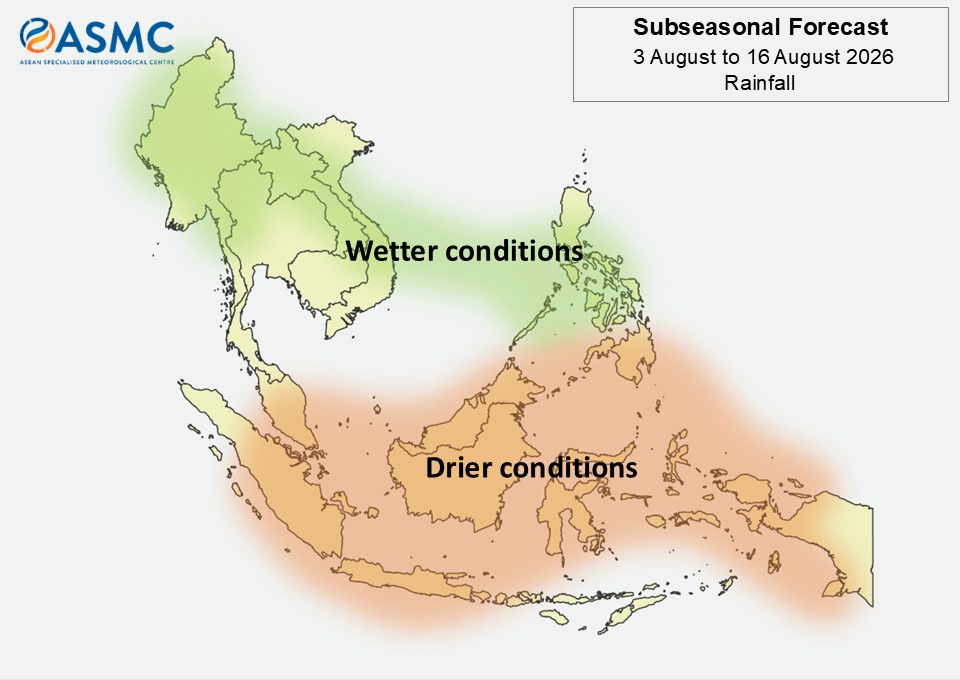
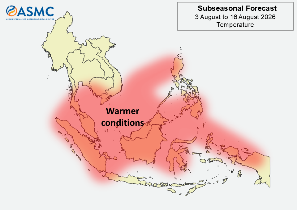
figure1

Figure 1: Rainfall Outlook

figure2

Figure 2: Temperature Outlook

Over much of the northern ASEAN region, wetter conditions are predicted in the next fortnight (3 – 16 August). The highest likelihood of wetter conditions is over the northwestern parts in Week 1 (3 – 9 August), and over the southern and eastern parts in Week 2 (10 – 16 August).

Over much of the southern ASEAN region, drier conditions are predicted in the next fortnight (3 – 16 August).

Warmer than usual temperatures are predicted over much of the ASEAN region in the next fortnight (3 – 16 August), except for most of Mainland Southeast Asia and the southern Maritime Continent.

A weakening Madden-Julian Oscillation (MJO) signal was present over the Western Hemisphere (Phase 8) in late July 2026, based on the RMM index. Most models predict an MJO signal to develop over the Western Pacific (Phase 6) during Week 1 (3 – 9 August), although models disagree whether the signal will continue to propagate or weaken during Week 2 (10 – 16 August).

The outlook is assessed for the region in general, where conditions are relative to the average conditions for the corresponding time of year. For specific updates on the national scale, the relevant ASEAN National Meteorological and Hydrological Services should be consulted.
July 16, 2026

Subseasonal Weather Outlook (20 July – 2 August 2026)

Subseasonal Weather Outlook (20 July – 2 August 2026)

Issued: 16 July 2026
First forecast week: 20 – 26 July 2026
Second forecast week: 27 July – 2 August 2026

figure1

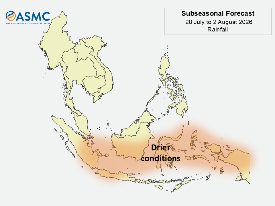
Figure 1: Rainfall Outlook

figure2

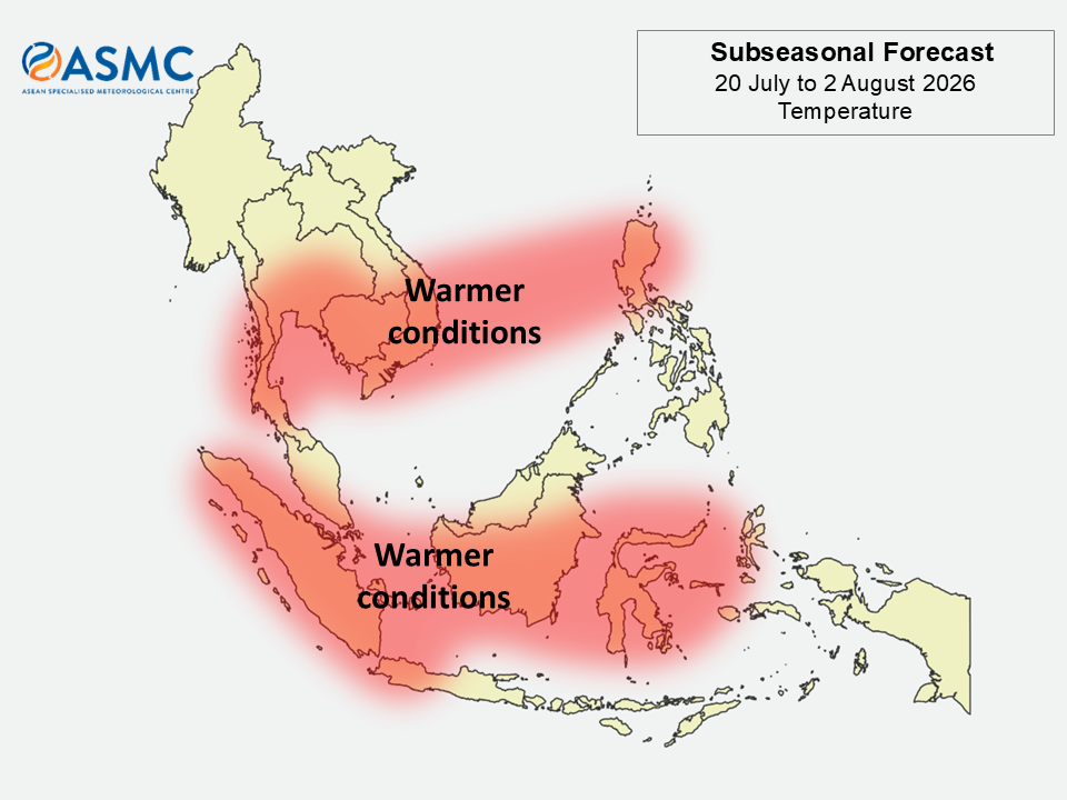
Figure 2: Temperature Outlook

Drier conditions are predicted over the equatorial region and parts of the southwestern Maritime Continent in the next fortnight (20 July – 2 August).

Warmer than usual temperatures are predicted over much of the western and central Maritime Continent as well as over most of southern Mainland Southeast Asia and parts of northeastern Maritime Continent in the next fortnight (20 July – 2 August).

A Madden-Julian Oscillation (MJO) signal was present over the Western Pacific (Phase 7) in the first half of July 2026, based on the RMM index. Most models predict the MJO signal to be over the Western Pacific (Phase 7) or the Western Hemisphere (Phase 8) at the start of Week 1 (20 – 26 July) and then weaken and become indiscernible by the start of Week 2 (27 July – 2 August).

The outlook is assessed for the region in general, where conditions are relative to the average conditions for the corresponding time of year. For specific updates on the national scale, the relevant ASEAN National Meteorological and Hydrological Services should be consulted.
July 14, 2026

Review of Regional Weather for June 2026

Review of Regional Weather for June 2026


1. Overview

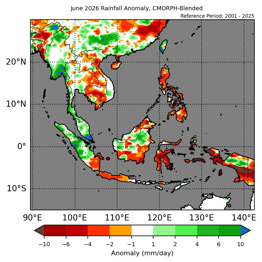
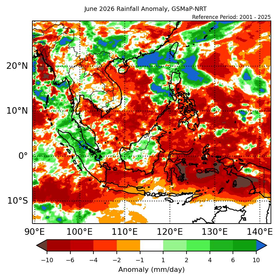
1.1 During June 2026, a mix of near- to above-average rainfall was recorded over the ASEAN region (Figure 1). Parts of southwestern Mainland Southeast Asia recorded above-average rainfall while eastern parts of Mainland Southeast Asia recorded below-average rainfall based on the two datasets (GSMaP-NRT and CMORPH-Blended). The western Maritime Continent recorded mostly above-average rainfall, with most of the southern and eastern region recording below-average rainfall, with a mix of below- to above-average rainfall over the central Maritime Continent. The largest positive (wetter) anomalies were recorded over the southern Malay Peninsula and southern and northern Myanmar, with the largest negative (drier) anomalies over Sulawesi and the Maluku Islands.

1.2 The observed rainfall anomaly pattern of above-average rainfall over southwestern Mainland Southeast Asia and the below-average rainfall over the southern and eastern Maritime Continent are consistent with the predictions from the subseasonal weather outlooks for June 2026 (25 May – 7 June 2026, 8 – 21 June 2026 and 22 June – 5 July 2026). The wet anomalies over southwestern Mainland Southeast Asia and the dry anomalies over the southern and eastern Maritime Continent are consistent with the seasonal outlook for June 2026. However, the seasonal outlook predicted below-normal rainfall as the dominant tercile for the western Maritime Continent for June 2026.

era5_rainfall_anomalies
cmorph_bld_rainfall_anomalies
Figure 1: Rainfall anomalies for June 2026 based on GSMaP-NRT data (left) and CPC Global Unified Gauge-based Analysis data (right). The climatological reference period is 2001-2024. Green colour denotes above-average rainfall (wetter), while orange denotes below-average rainfall (drier).


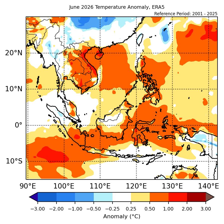
1.3 Above-average temperature was recorded over the eastern half of Mainland Southeast Asia, with near-average temperature elsewhere (Figure 2). Above-average temperature was recorded for much of the Maritime Continent. The warmest anomalies (1°C – 2°C above average) were recorded over parts of central Viet Nam. The coolest anomalies (-0.25°C – -0.5°C below average) were recorded over parts of central Myanmar and Papua.

era5_temperature_anomalies
Figure 2: Temperature anomalies for June 2026 based on ERA-5 reanalysis. The climatological reference period is 2001-2024. Red colour denotes above-average temperature (warmer), while blue denotes below-average temperature (colder).


2. Climate Drivers

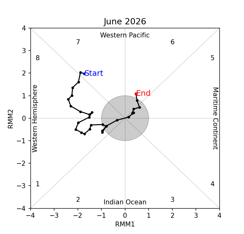
2.1 The Madden-Julian Oscillation (MJO) was active over the Western Hemisphere during much of June 2026. In Week 1, an MJO signal propagated eastwards from the Western Pacific (Phase 7) to the Western Hemisphere (Phase 8). The MJO signal continued propagating eastwards in the western Hemisphere (Phases 8 and 1) in Week 2, before decaying in Week 3 and becoming inactive by the end of the third week of the month. An MJO signal then emerged over the Western Pacific (Phase 6) at the end of June. Phase 8 tends to bring drier conditions to much of the ASEAN region, with Phase 1 can increase rainfall over parts of the western and central equatorial region, while reducing the likelihood of rainfall over much of the rest of the ASEAN region. This is somewhat in drier conditions over the eastern Maritime Continent and wetter conditions in western Maritime Continent in Figure 1.

mjo_phase_diagram


Figure 3: The MJO phase diagram. The diagram illustrates the movement of the MJO through different phases, which correspond to different locations along the equator (denoted in the text with the first day of the month in blue and the last day of the month in red). The distance of the index from the centre of the diagram is related to the strength of the MJO. Values within the grey circle are considered weak or indiscernible (data from the Bureau of Meteorology, Australia).


2.2 The El Niño conditions are now present in June 2026, with the Indian Ocean Dipole (IOD) in the neutral state. El Niño conditions can bring drier conditions to the Maritime Continent at this time of the year.


July 13, 2026

Review of Regional Haze Situation for June 2026

Review of Regional Haze Situation for June 2026

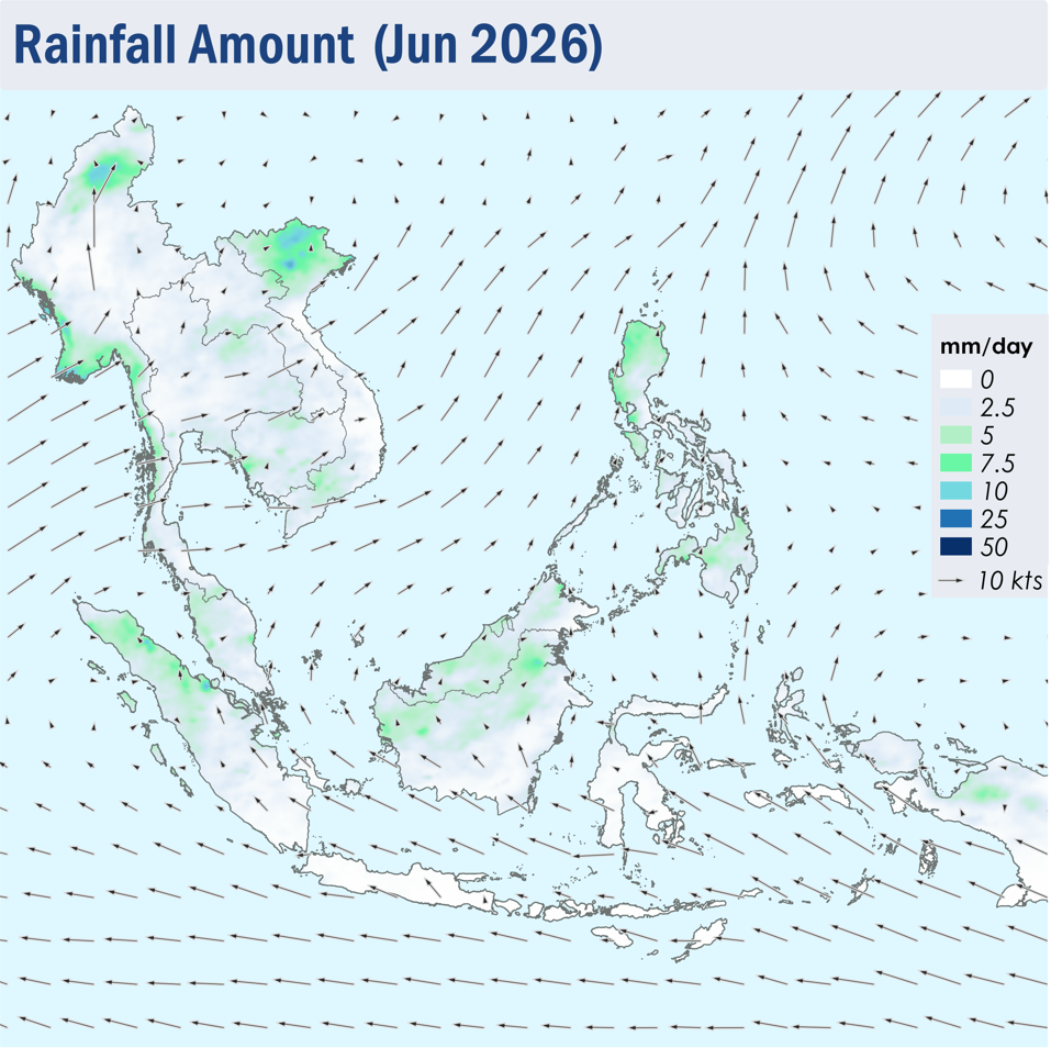
1.1 Southwest Monsoon conditions became fully established in early June 2026. The prevailing winds across the southern ASEAN region blew mainly from the southeast to south, while the prevailing winds over the northern ASEAN region blew mostly from the south to west (Figure 1).

1.2 Rainfall prevailed over most parts of the ASEAN region during the review period, except over the southern parts of Sumatra and Borneo, as well as Java and the Lesser Sunda Islands where drier conditions were observed (Figure 1).

Figure 1: Average Daily Rainfall and Mean Winds for June 2026. (Source: JAXA GsMaP and GFS, respectively)


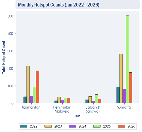
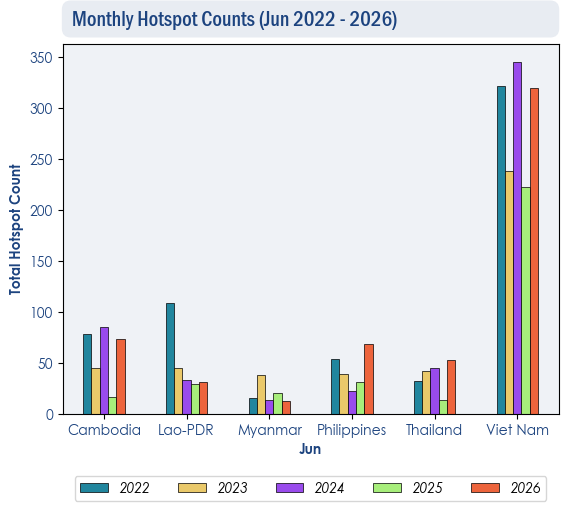
1.3 Over the southern ASEAN region, the hotspot counts for June 2026 were generally lower than or comparable to previous years (Figure 2). Over the northern ASEAN region, the hotspot counts for June 2026 were generally comparable to previous years, except in Thailand and the Philippines, where hotspot counts were slightly higher compared to the past 5 years (Figure 3).

Figure 2: Hotspot counts for the southern ASEAN region for June (2022-2026) based on NOAA-20 satellite surveillance.


Figure 3: Hotspot counts for the southern ASEAN region for June (2022-2026) based on NOAA-20 satellite surveillance.


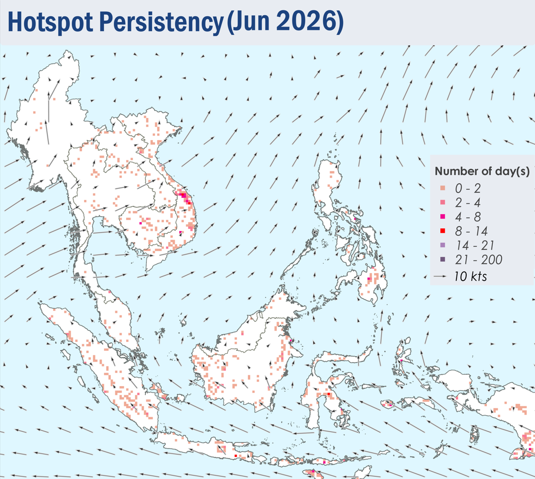
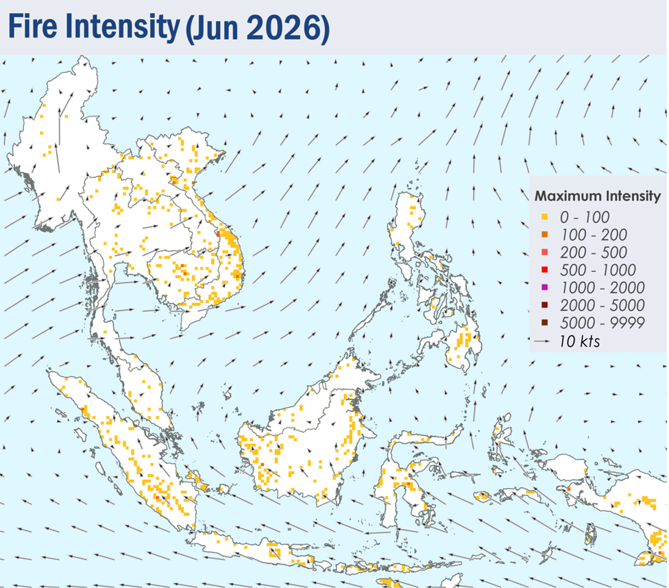
1.4 During the review period, few to isolated hotspots were detected in the ASEAN region, with more persistent and intense fires in the southern parts of Sumatra, West Kalimantan, Java and the Lesser Sunda Islands, as well as parts of Viet Nam (Figure 4). During periods of dry weather over the southern ASEAN region, slight to moderate smoke plumes were observed emitting from hotspots detected mainly in the northern and central parts of Sumatra, Java and parts of Borneo (Figures 6, 7, 8 and 9).


Figure 4: Distribution of hotspots detected in June 2026 based on NOAA-20 satellite surveillance.


Figure 5: Maximum fire intensity in June 2026 based on NOAA-20 satellite surveillance.


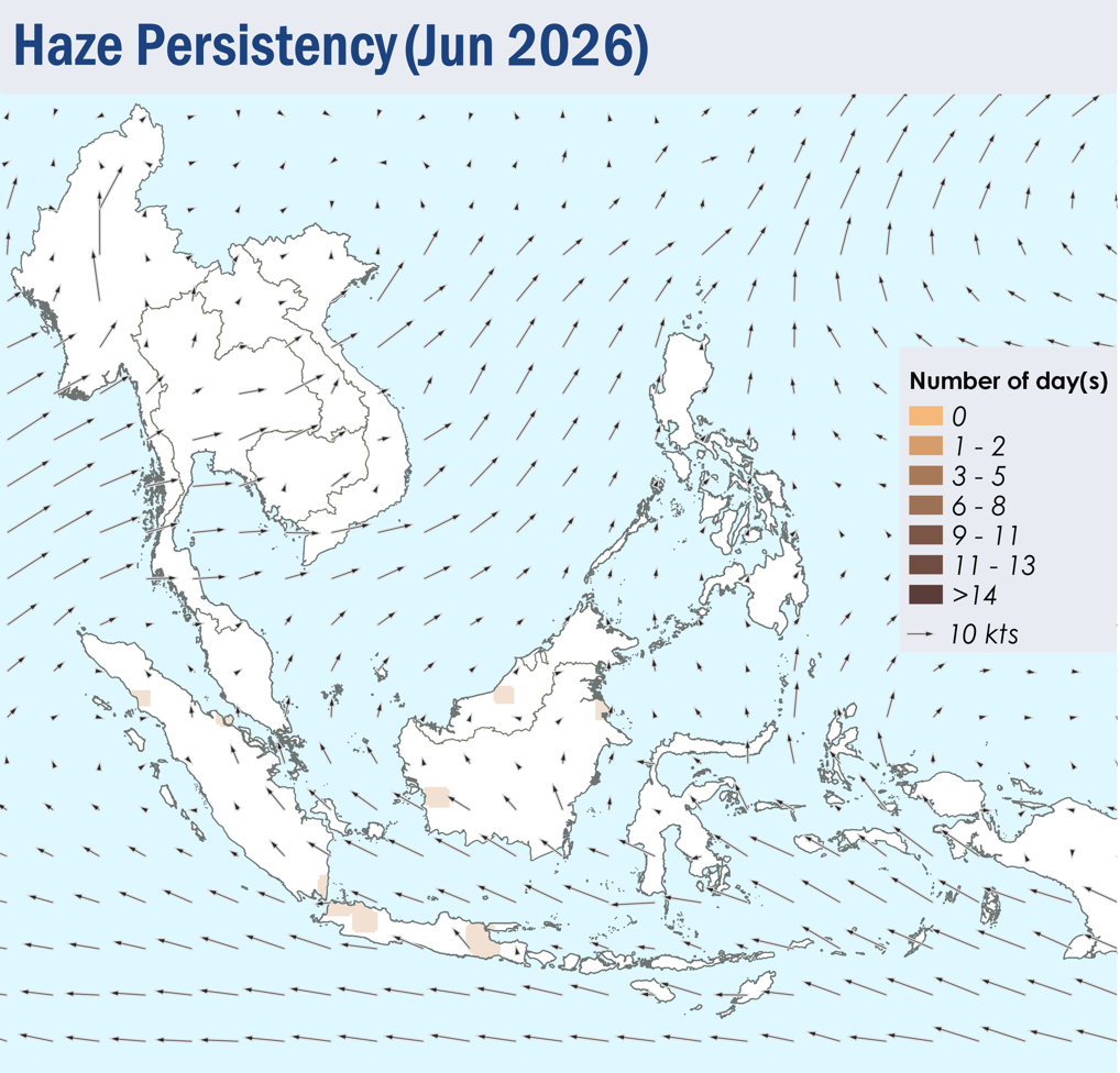
Figure 6: Number of days with moderate to dense smoke haze observed in June 2026 based on satellite imagery, ground observations, and air quality reports.


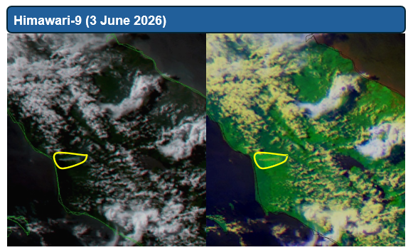
Figure 7: Moderate localised smoke plume observed over the northern parts of Sumatra on 3 June 2026. (Source: NOAA-20 satellite surveillance)


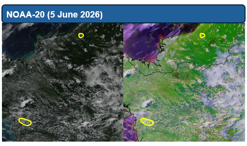
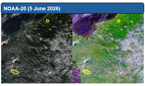
Figure 8: Moderate localised smoke plumes were observed over West Kalimantan and the central parts of Sarawak on 5 June 2026. (Source: Himawari-9 satellite surveillance)


Figure 9: Moderate localised smoke plume observed over the eastern parts of Java on 29 June 2026. (Source: Himawari-9 satellite surveillance)

July 10, 2026

Alert20260710 – Activation of Alert Level 1 for the Southern ASEAN Region

Start of Dry Season for the Southern ASEAN Region

Dry weather conditions were observed over most parts of the southern ASEAN region as Southwest Monsoon conditions became established, with prevailing winds blowing from the southeast or southwest. Isolated hotspots were detected mostly in Sumatra and Kalimantan, with a total of 48 and 45 hotspots detected on 8 July 2026 and 9 July 2026 in the southern ASEAN region respectively, based on NOAA-20 satellite surveillance. Localised smoke plumes were also observed in various parts of Sumatra, Kalimantan and Java.

The hotspot and smoke haze situation over the region may deteriorate as dry weather is expected to continue over the southern ASEAN region in the coming months.

July 1, 2026

Subseasonal Weather Outlook (6 – 19 July 2026)

Subseasonal Weather Outlook (6 – 19 July 2026)

Issued: 1 July 2026
First forecast week: 6 – 12 June 2026
Second forecast week: 13 – 19 July 2026

figure1

Figure 1: Rainfall Outlook

figure2

Figure 2: Temperature Outlook

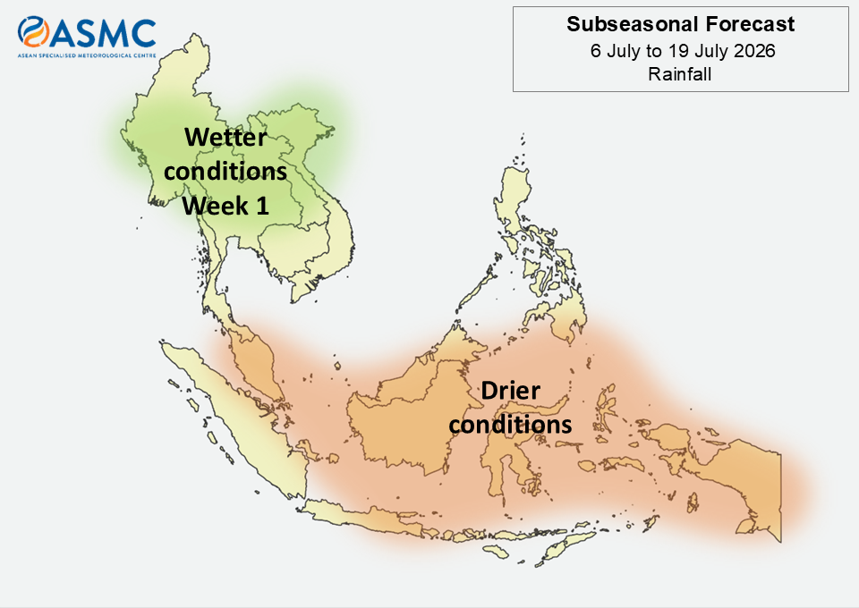
Wetter conditions are predicted over much of the northern half of Mainland Southeast Asia in Week 1 (6 – 12 July).

Drier conditions are predicted over much of the southern ASEAN region in the next fortnight (6 – 19 July). The highest chance of drier conditions is over the central and eastern equatorial region.

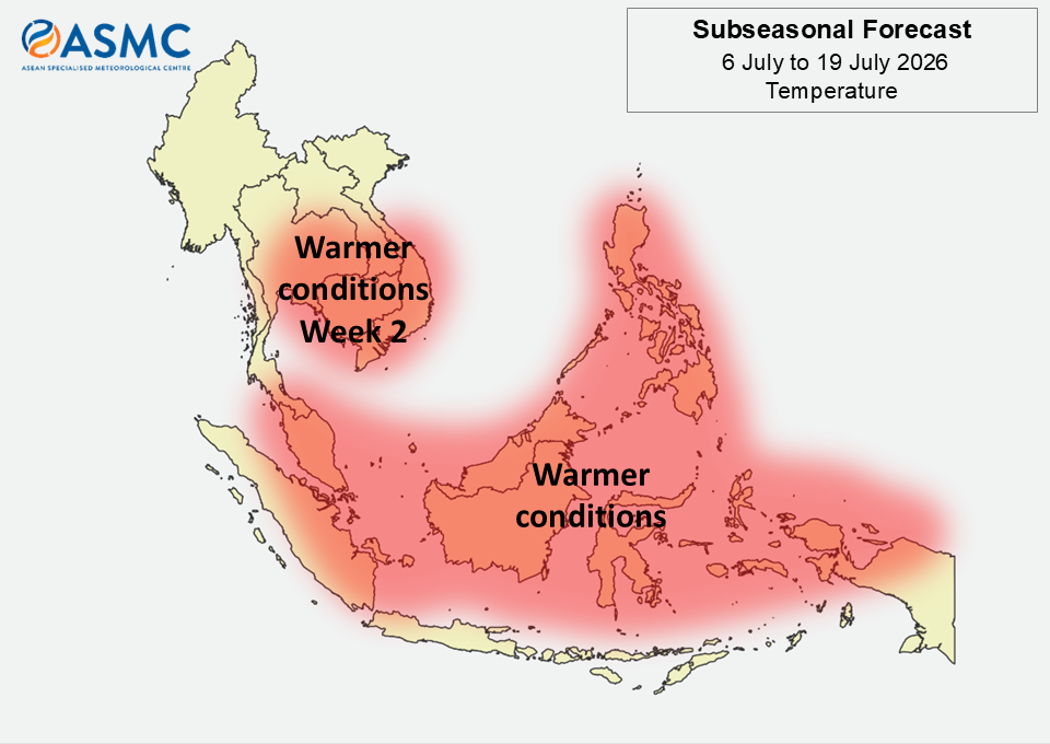
Warmer than usual temperatures are predicted over much of the Maritime Continent in the next fortnight (6 – 19 July). Warmer than usual temperatures are also predicted over most of central and southeastern Mainland Southeast Asia in Week 2 (13 – 19 July).

There were signs of a Madden-Julian Oscillation (MJO) signal developing towards the end of June 2026. Most models predict the MJO signal to propagate through the Western Pacific (Phase 6 to Phase 7) during Week 1 (6 – 12 July) and then weaken in Week 2 (13 – 19 July).

The outlook is assessed for the region in general, where conditions are relative to the average conditions for the corresponding time of year. For specific updates on the national scale, the relevant ASEAN National Meteorological and Hydrological Services should be consulted.